Group P - Collaborative Climate Adaption Project
| Area | Tegocigalpa's Downtown and Erodible Areas | |||||||||||
| Place | Tegucigalpa | |||||||||||
| Country | Honduras | |||||||||||
| Topic | Climate Change Adaptation and Mitigation Proposals for Tegucigalpa | |||||||||||
| Author(s) | Galina Rojević, Linus Clade, Mario Matamoros | |||||||||||

| ||||||||||||
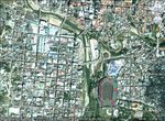
| {{#widget:GoogleMaps | width=300 | height=200 | lat=14.074144 | lng=-87.19471 | zoom=13 | centermarker=yes | maptypecontrol=yes | overviewmapcontrol=yes | largemapcontrol=yes | scalecontrol=yes
}} | ||
Rationale: Why have you selected this case study area?
Honduras is the second poorest country in Latin America and identified by the World Bank Organization as the third most vulnerable country in the World.[5] Despite of its great climate conditions, in 2011 Honduras’s Government had to call for State of Emergency every 38 days. [6] Most of its vulnerability is due to its poor infrastructure, high population growth rate, unemployment which results in criminality, its inexistent land and city planning, and its increasing annual precipitation. Tegucigalpa, itself is a mirror of poor planning. Most of the city’s neighborhoods are located on places where buildings were not plausible. Most of Tegucigalpa’s soil conditions are poor for construction purposes and often result in erosion. Tegucigalpa’s topography and poor drainage infrastructure often cause the city to be flooded and this is terrible considering that Honduras has a high annual precipitation.
Authors' perspectives
It is very diffcult to explain the complexity of Honduran reality. Honduras suffers what
most of 3rd world countries suffer: Considerable Social Wealth distribution differences, Political
crisis, high assassination rates and no future planning. The climate change problems will
affect primarily those with low economic incomes, which live in the areas that were
not planned or meant to be occupied. The social and security problems maintain the
average Honduran distracted from concerning on Climate change. Natural Disasters then
happen and thousands of people loose their homes, others suffer severe damage on their
working facilities and the aid never gets to them because it’s lost in bureaucratic stages
and the system’s corruption.
Little investigation has been done in Honduras regarding on Climate Change although
there has been an increase in annual precipitation during the last years in winter and
much more droughts during summer. To make this worse, Honduras has being absorbed
by the political crisis originated by the Coup d’état in 2009, the emergence of a socialist
political power, Venezuela’s political interference and plenty of assassinations to lawyers,
journalists, political leaders and policemen. All this social confict that is perceived more in
Tegucigalpa (political capital from Honduras), has obsessed Hondurans overshadowing
other important issues as natural disasters mitigation.
It’s also widely known that Latin-American culture and planning are like water and oil. The Honduran
carefree way of living has resulted on poor response to natural disasters, long-term
recuperation from hurricanes, earthquakes and floods.
Landscape and/or urban context
Tegucigalpa, Honduras’s capital has a population of over a million habitants. The Choluteca River crosses the city from north to south (which often floods the city’s downtown and poor residential areas). There is no landscape design related to Tegucigalpa’s rivers, surrounding mountains, historical center and statues. Few parks are found on the downtown with very little maintenance. The city has adopted the Consumerism-individualistic life-style in which cars are more important than pedestrians. No planning has been developed for Tegucigalpa’s rapid urban growth, which causes plenty of traffic. The public transportation system is very deficient and has no well structured circuits. Tegucigalpa hasn’t any main Bus station but many stations that are located on the most dangerous neighborhoods. Most of the houses built in Tegucigalpa must have a perimeter wall protecting the inhabitants from criminality. These walls often include security cameras, electrical wire and house alarms. Tegucigalpa’s topography is variable, its surrounded by mountains and hills and the lowest point is at the city’s downtown. All the water from precipitation and drainage ends up here. Tegucigalpa also suffers from constant erosion due to its poor soil conditions and the land-invasion to these areas were they build houses without any quality control.
-
![Land Use in Tegucigalpa Urban Area, chart made by Galina Rojevic[1]](/images/thumb/a/ac/Land_Use_Percent.jpg/150px-Land_Use_Percent.jpg) Land Use in Tegucigalpa Urban Area, chart made by Galina Rojevic[1]
Land Use in Tegucigalpa Urban Area, chart made by Galina Rojevic[1] -
 Land Use in Tegucigalpa Urban Area, chart made by Mario Matamoros
 -
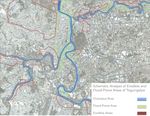 Erodible and Flood-Prone Areas, chart made by Mario Matamoros
![Land Use in Tegucigalpa Urban Area, chart made by Galina Rojevic[1]](/index.php?title=File:Land_Use_Percent.jpg)


Cultural/social/political context
As mentioned above, Honduras political crisis is a conversation subject for every Honduran. Two conservative parties have governed Honduras during the last 100 years, and military coups took place 30 years ago. However, during the presidential period between 2006 and 2010, Manuel Zelaya, the former president change the direction of its government from conservative to socialist due to his alliance with Hugo Chavez. This resulted in a considerate popular discontent in some social sectors as the religious groups, conservative groups and other financial groups. These groups eventually forced Zelaya to quit the presidency because he had plans to change the constitution and remain as president, which ended up as the 2009 coup d’etat. Since then, Zelaya was forced to leave the country and other social groups decided to create a socialist political party to change Honduras’s Status Quo. From 2009, many assassinations to journalists, lawyers, political and religious leaders have taken place. The criminality rate has increased converting Honduras in the country with the highest criminality rate all over the world. Poverty reaches 80% of Honduras' population[7], 1/3 of the working population is unemployed. Social differences are big and the poor often suffer more from natural disasters, as those conforming the middle-class and high-class.
Generally, the public services are defcient and Hondurans choose (when economically possible) to use private services such as education, transportation and health. Most of Honduran traditions are related to its past as a former Colony from Spain and to Roman Catholic traditions. Other traditions come from its different ethnical groups such as the Garifunas (slaves who where brought from Africa) and other native indian groups. Honduras is also famous for being part of the Mayan civilization and having plenty of mayan ruins on its occidental part.
-
 Traditional Rug Making For Easter Celebrations In Comayagua, Photo: Mario Matamoros
 -
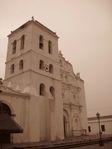 Comayagua's Cathedral, Photo: Mario Matamoros
 -
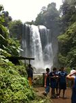 Puhlapanzak Waterfalls, Photo: Mario Matamoros
 -
 Bay Islands, Honduras, Photo: Mario Matamoros
 -
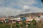
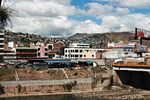
 View of Tegucigalpa, Photo: Eduardo Matamoros


Local Climate
Honduras is characterized by its tropical climate throughout the year, which is divided in two subcategories: in its coasts it’s rainy tropical and tropical dry in its central region. Nevertheless, Honduras’s annual precipitation varies from 1900mm to 2500mm. The average temperature is 23º C but in March and April it can get to 40ºC and 15ºC during December and January. There are only two seasons in Honduras; the dry season, which takes places between November and March and the rainy season from May to October.
Teguicigalpa features a more moderate form of a tropical wet and dry climate. Of the major Central American cities, Tegucigalpa's climate is among the most pleasant due to its high altitude. Like much of central Honduras, the city has a tropical climate, though tempered by the altitude—meaning less humid than the lower valleys and the coastal regions—with even temperatures averaging between 19 °C (66 °F) and 23 °C (73 °F) degrees.[[8]] The months of December and January are coolest, with an average min/ low temperature of 14 °C (57 °F); whereas March and April—popularly associated with Easter's holidays—are hottest and temperatures can reach up to 40 °C (104 °F) degrees on the hottest day.[9] The dry season lasts from November through April and the rainy season from May through October.[10] There is an average of 107 rainy days in the year, June and September usually the wettest months. The average sunshine hours per month during the year is 211.2 and the average rainy days per month is 8.9. The average sunshine hours during the dry season is 228 per month while 182.5 millimetres (7.19 in) is the average monthly precipitation during the wet season. The wettest months of the rainy season are May—June and September—October, averaging 16.2 rainy days during each of those periods. [11]
-
![Annual Average Temperature of Tegucigalpa, chart made by Galina Rojevic [2]](/images/thumb/3/38/TemperatureChart.jpg/250px-TemperatureChart.jpg) Annual Average Temperature of Tegucigalpa, chart made by Galina Rojevic [2]
Annual Average Temperature of Tegucigalpa, chart made by Galina Rojevic [2]
Analysis of vulnerability
Tegucigalpa’s vulnerability is due to these factors:
- Poor drainage infrastructure:Tegucigalpa's authorities have not done many changes to the drainage infrastructure in Tegucigalpa since the 1970's, nevertheless its population increased in more than a 200%.[12] This results on constant stagnant water, and difficulty to get the rainwater away from the streets and residential areas.
- Existing residential areas located in erodible and hard to reach places:Poor planning and supervision has permited low-income citizens to develop informal residential areas in dangerous parts of the city, which have poor soil conditions and no infrastructure.
- Constant ground invasion in dangerous topographical zones:The economical crisis and the uncontrolled birth rate had cause Honduran population to increase in a very rapid rate without any social and economical development to absorb it. This causes many hondurans to move to invade zones with no land values but put in risk their lives because of the constant natural disasters.
- No planning related to flood, evacuation and containment of landslides Tegucigalpa authorities as well as the local government have not yet developped sustainable strategies dealing with:
- Tegucigalpa's urban growth
- Mitigation and adaptation to Natural Disasters
- Improving the citizens living conditions and public spaces
-
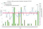 Correlation vs Rain annual number of Landslides, Tegucigalpa, 1979-2010, graphic made by Galina Rojevic .
 -
![Correlation number of landeslides vs Number Precipiation Monthly average and maximum, Tegucigalpa. Graphic made by Galina Rojevic [3]](/images/thumb/4/49/SAT_deslizamientos_TGU-7.jpg/150px-SAT_deslizamientos_TGU-7.jpg) Correlation number of landeslides vs Number Precipiation Monthly average and maximum, Tegucigalpa. Graphic made by Galina Rojevic [3]
Correlation number of landeslides vs Number Precipiation Monthly average and maximum, Tegucigalpa. Graphic made by Galina Rojevic [3] -
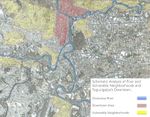
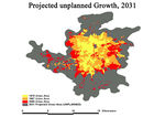 Projected Unplanned Growth, 2031. Graphic made by Galina Rojevic.
 -
![Project Planned Growth, 2031. Graphic made by Galina Rojevic [4]](/images/thumb/d/db/Projected_planned_growth.jpg/150px-Projected_planned_growth.jpg) Project Planned Growth, 2031. Graphic made by Galina Rojevic [4]
Project Planned Growth, 2031. Graphic made by Galina Rojevic [4]

![Correlation number of landeslides vs Number Precipiation Monthly average and maximum, Tegucigalpa. Graphic made by Galina Rojevic [3]](/index.php?title=File:SAT_deslizamientos_TGU-7.jpg)

![Project Planned Growth, 2031. Graphic made by Galina Rojevic [4]](/index.php?title=File:Projected_planned_growth.jpg)
Proposals for Climate Change Adaption
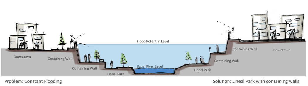
1. Development of linear parks in the proximities of Choluteca Riverbed The linear parks will serve two specific functions:
-The linear parks will delimitate the riverbed areas, the green areas and the city downtown as well as other vulnerable neighborhoods, improving the aesthetic and appearance of the City. This will also improve the living conditions of those people working and living in these areas since they will be open for everyone.
-The linear parks will be conformed of terraces and containing walls at different levels so that possible future floods won’t reach the city downtown and other nearby areas.
-The linear parks will also help decrease the deforestation that exists in the city by being buffer ecological areas.
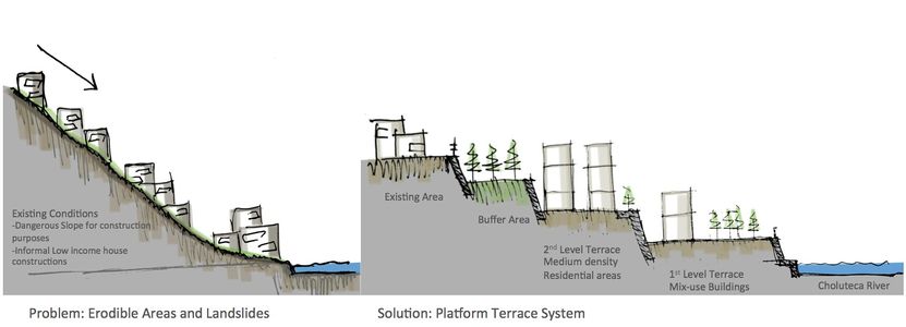
2. Development of Platforms and terraces in highly erodible areas. The construction of terraces and parallel platforms will help:
-Decrease the number of houses that collapse every year due to intense raining and erosion.
-Help organize the city infrastructure making it easy to develop public system circuits in parallel platforms.
-Improve the level of urbanization planning, making more area suitable for construction in a sustainable way.
-Development of ecological buffer areas
- Increase the percentage of green spaces in Tegucigalpa
-Decrease land degradation.
-
 Adaptation Sketch For Climate Change in Tegucigalpa. Sketch by Mario Matamoros and Linus Clade.
 -
 Adaptation Sketch For Climate Change in Tegucigalpa. Sketch by Mario Matamoros and Linus Clade.


Proposals for Climate Change Mitigation
How is a city like Tegucigalpa able to mitigate the climate change and its consequences? Apart from the general actions such as the proposals from the World Bank which relies on the United Nations Environment Programme (UNEP) and apart from the technical-scientific approach to reduce our CO2 emissions such as Geo- or Climate-Engineering we would like to point out what the city of Tegucigalpa can do in order to ameliorate the living conditions of its habitants for the future.
-Education. Teaching of climate change factors to raise awareness and understanding for climate and environmental issues. The Ministry of Education must compromise to implement climate change knowledge as a basic subject in the early school years and reinforce it through High school.
-Preparation of action plans to deal with hazards such as floods and land erosion. The offices in charged of natural disasters and civil construction shall compromise to prepare action plans before the rainy seasons begin so that local committees would be informed on how to prevent great losses and damages to their community.
-Relocation of destroyed informal settlements after natural disasters. The offices in charged of natural disasters and civil construction as well as the town hall should agree beforehand on the relocation of citizens who live in dangerous and vulnerable areas to reduce possible human casualties.
-Designate potential expansion areas for low-income families. The Town Hall and the Ministry of Environmental Protection shall agree beforehand in the destination of urban development areas for people with low incomes to stop the land invasion in vulnerable areas and the lost of human lives in natural disasters.
Scenario 2060 (or Tomorrow?)
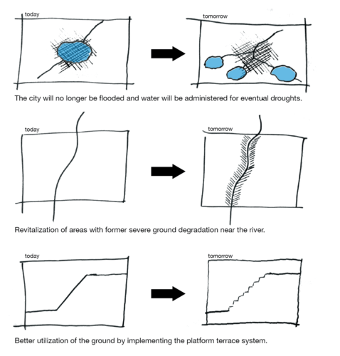
-The implementation of the platform terrace system solution improved the life quality of people who lived in the erodible areas by improving the appearance of their neighborhood and reducing the risks of devastating erosions and landslides.
-The green surface in the capital increased significantly because other parts of the city with similar erosion problems adopted this system.
-The platform terrace system became a significant element in Tegucigalpa’s identity landscape.
-The Buffer Areas located in the terrace platforms and the river lineal parks helped reduce the levels of CO2 emissions and Tegucigalpa’s air got to healthy levels.
-The lineal parks throughout the riverbed helped contain the constant flood during the rainy seasons in Tegucigalpa, diminishing the number of economical lost in the city’s downtown and the number of houses affected by rain water.
-The lineal parks promoted the interactions of citizens who were not used to have public open spaces in their city. -The lineal parks also improve the city’s image for touristic purposes. -Tegucigalpa became a much healthier and safer place to live, even for those with low incomes.
-
 Objectives of the Adaptation and Mitigation Proposals. Sketch by Linus Clade.

What can be generalized from this case study?
We can generalize that Climate change doesn’t affects by itself the population of a specific area. Climate Change is a result of bad practicing and living conditions of humans in a specific place. Climate change produces alterations in the normal climatic conditions affecting the already damaged natural environment. These alterations often conduce to natural disasters and meteorological phenomena that result in great human, natural and economical losses.
-The challenge of many professionals involved in land planning and urbanism has to deal with precarious urban existing situations that condition the sustainable development of a region.
-The bigger the population, the bigger the measure that must be taken. This means that when dealing with big urban centers with lots of problem of landslides, water supply, and flooding, radical measures must be taken to change the direction the problem has lead to.
-The natural disasters are the way Nature finds its equilibrium by counteracting the ecological impact the human has made in his environment. Our responsibility is to find the equilibrium in which we affect the least the original conditions of a place without limiting the future of a community.
-The last thing we conclude is that long term planning would have diminish the problems Tegucigalpa has today, it is important always to look ahead in the future because the uncontrolled population and urban growth can lead to severe environmental damages, both ecologically and human.
Presentation Slides
-
 Presentation slide 1
 -
 Presentation slide 2
 -
 Presentation slide 3


Image Gallery
-
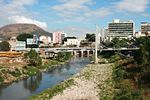
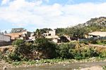
 Downtown of Tegucigalpa, As shown in the picture, there's no landscape design in the river area which divides the city's downtown and historical center.
 -
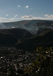
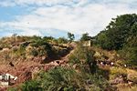
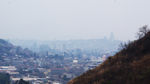 View of the topographical landscape of Tegucigalpa, deforestation on the hills and ground degradation, Photo by Fabricio Estrada
 -
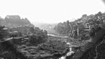 Panoramic View of River Area in Tegucigalpa, No landscape architecture involved in the River Area plus dangeorus proximity of houses in precarious state and no containing walls to protect from eventual floods or landslides, Photo by Fabricio Estrada
 -
 Riverbed of Choluteca River in Tegucigalpa, Photo by Eduardo Matamoros
 -
 No protective measures against flood in Comayaguela, Tegucigalpa's twin city, Photo by Eduardo Matamoros
 -
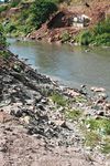 Great levels of pollution and poor quality soil in the riverbed, Photo by Eduardo Matamoros
 -
 Houses in precarious conditions in erodible areas around Choluteca River, Photo by Eduardo Matamoros
 -
 No parks or containing structures in the proximities of the river, Photo by Eduardo Matamoros
 -
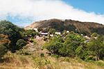
 Informal settlements in potential erodible areas around the Choluteca River, Photo by Eduardo Matamoros
 -
 Great levels of pollution, no landscape concept to improve the city's aesthetics, Photo by Eduardo Matamoros


References
Please add literature, documentations and weblinks
- https://openknowledge.worldbank.org/handle/10986/9477
- https://openknowledge.worldbank.org/handle/10986/9477
- https://www.wfp.org/countries/honduras/overview
- El Heraldo December 5 2011. https://www.elheraldo.hn/Secciones-Principales/Al-Frente/Cada-38-dias-el-gobierno-del-presidente-Porfirio-Lobo-emite-un-estado-de-emergencia
- La Prensa 26.10.2010 https://archivo.laprensa.hn/Pa%C3%ADs/Ediciones/2010/10/26/Noticias/130-000-familias-en-riesgo-por-clima-en-Tegucigalpa
- https://cambioclimatico.cridlac.org/honduras
- Rapid Urbanization in Tegucigalpa, Honduras, Shlomo Angel with Katherine Bartley, Mary Derr, Anshuman Malur, James Mejía, Pallavi Nuka, Micah Perlin, Sanjiv Sahai,
Michael Torrens, and Manett Vargas, Princeton University, February 2004
- https://www.wfp.org/countries/honduras/overview World Food Programme
- http://cambioclimatico.cridlac.org/honduras
- http://en.wikipedia.org/wiki/Tegucigalpa#cite_note-73
- "Spanish: Weather in Honduras". http://www.LosMejoresDestinos.com. 2007-06-10. Retrieved 2011-07-05.
- La Tribuna editor (2010-04-23). "Spanish: Next Tuesday will be hottest day of the year". LaTribuna.hn. Retrieved 2011-09-28.
- "Honduras, When to go and Weather". http://www.lonelyplanet.com. 2010-08-23. Retrieved 2011-07-05.
- http://pdf.usaid.gov/pdf_docs/PNACR106.pdf
- http://hydro.ou.edu/Publications/PDFs/2011/74.Dalia_2011_landslides_EES.pdf
- http://www.adaptationlearning.net/hon http://www.adaptationpartnership.org/sites/default/files/LAC%20%20Central%20America%20Country%20profiles%20%28Honduras%29.pdfduras/profile
- http://wws.princeton.edu/research/final_reports/wws591g_f03.pdf7
- http://cdiac.ornl.gov/trends/emis/hon.html
- http://hydro.ou.edu/Publications/PDFs/2011/74.Dalia_2011_landslides_EES.pdf
- http://www.unesco.org/new/fileadmin/MULTIMEDIA/FIELD/San%20Jose/pdf/Informe%20Final%20Honduras.pdf
About categories: You can add more categories with this tag: "", add your categories