Group P - Collaborative Climate Adaption Project
| Area | please enter the area name here | |
| Place | Tegucigalpa | |
| Country | Honduras | |
| Topic | please enter the topic here | |
| Author(s) | Please enter your name(s) | |

| ||
|
| ||
Rationale: Why have you selected this case study area?
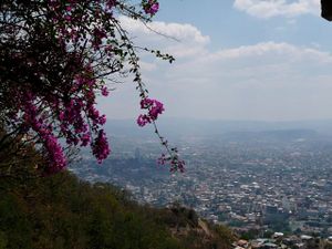
Honduras is the second poorest country in Latin America and nominated by the World Bank Organization as the third most vulnerable country in the World. Despite of its great climate conditions, in 2011 Honduras’s Government had to call for State of Emergency every 38 days. Most of its vulnerability is due to its poor infrastructure, high population growth rate, unemployment which results in criminality, its inexistent land and city planning, and its increasing annul precipitation (which is one of the world’s 20 most highest). Tegucigalpa, itself is a mirror of poor planning. Most of the city’s neighborhoods are located on places where buildings were not plausible. Most of Tegucigalpa’s soil conditions are poor for construction purposes and often result in erosion. Tegucigalpa’s topography and poor drainage infrastructure often cause the city to be fooded and this is terrible considering what that Honduras has a high annual precipitation.
Authors' perspectives
- What theoretical or professional perspective do you bring to the case study?
Landscape and/or urban context
- Biogeography, land use patterns, cultural features, overall character, history and dynamics
- ratio of green/blue and sealed/built-up areas
Illustration: Map; sketches; short descriptive analyses
Cultural/social/political context
- Brief explanation of culture, political economy, legal framework
Illustration: Bullet points, image, background notes
Local Climate
- What are the climatic conditions at present? Have there been extreme weather events in the near past?
- Which changes are expected? Is there any evidence?
Illustration: Table or time line
Analysis of vulnerability
- If you consider these potential changes - which aspects/functions of your case study would be affected?
Illustration: Map/diagram/sketches/photos/background notes
Proposals for Climate Change Adaption
- How could your case study area become more resilient to climate change?
- Which measures would need to be taken to adapt to the new situation?
- How could you assure sustainability of these measures?
- Please describe 2-3 measures
Proposals for Climate Change Mitigation
- Which measures would need to be taken to reduce greenhouse gas emissions and other drivers of climate change within your case study area?
- How could you assure sustainability of these measures?
- Please describe 2-3 measures
Your scenario
- How will this area look like in 2060?
- Please forecast one potential future development taking climate change into account
Illustration: Map/diagram/sketches photos and background notes
What can be generalized from this case study?
- Are there any important theoretical insights?
- Which research questions does it generate?
- Short statement plus background notes
Image Gallery
- Yourimage.jpg
your image text
- Yourimage.jpg
your image text
- Yourimage.jpg
your image text
- Yourimage.jpg
your image text
- Yourimage.jpg
your image text
- Yourimage.jpg
your image text
- Yourimage.jpg
your image text
- Yourimage.jpg
your image text
References
Please add literature, documentations and weblinks
About categories: You can add more categories with this tag: "", add your categories