Group P - Collaborative Climate Adaption Project
| Area | please enter the area name here | |||||||||||
| Place | Tegucigalpa | |||||||||||
| Country | Honduras | |||||||||||
| Topic | please enter the topic here | |||||||||||
| Author(s) | Please enter your name(s) | |||||||||||

| ||||||||||||
| {{#widget:GoogleMaps | width=300 | height=200 | lat=14.074144 | lng=-87.19471 | zoom=13 | centermarker=yes | maptypecontrol=yes | overviewmapcontrol=yes | largemapcontrol=yes | scalecontrol=yes
}} | ||
Rationale: Why have you selected this case study area?
Honduras is the second poorest country in Latin America and nominated by the World Bank Organization as the third most vulnerable country in the World.[4] Despite of its great climate conditions, in 2011 Honduras’s Government had to call for State of Emergency every 38 days. [5] Most of its vulnerability is due to its poor infrastructure, high population growth rate, unemployment which results in criminality, its inexistent land and city planning, and its increasing annual precipitation. Tegucigalpa, itself is a mirror of poor planning. Most of the city’s neighborhoods are located on places where buildings were not plausible. Most of Tegucigalpa’s soil conditions are poor for construction purposes and often result in erosion. Tegucigalpa’s topography and poor drainage infrastructure often cause the city to be flooded and this is terrible considering that Honduras has a high annual precipitation.
Authors' perspectives
It is very diffcult to explain the complexity of Honduran reality. Honduras suffers what
most of 3rd world countries suffer: Considerable Social Wealth distribution differences, Political
crisis, high assassination rates and no future planning. The climate change problems will
affect primarily those with poor economic incomes, which live in the areas, which were
not planned or meant to be occupied. The social and security problems maintain the
average Honduran distracted from concerning on Climate change. Natural Disasters then
happen and thousands of people loose their homes, others suffer severe damage on their
working facilities and the aid never gets to them because it’s lost in bureaucratic stages
and the system’s corruption.
Little investigation has been done in Honduras regarding on Climate Change although
there has been an increase in annual precipitation during the last years in winter and
much more droughts during summer. To make this worse, Honduras has being absorbed
by the political crisis originated by the Coup d’état in 2009, the emergence of a socialist
political power, Venezuela’s political interference and plenty of assassinations to lawyers,
journalists, political leaders and policemen. All this social confict that is perceived more in
Tegucigalpa (political capital from Honduras), has obsessed Hondurans overshadowing
other important issues as natural disasters mitigation.
It’s also widely known that Latin-American culture and planning are like water and oil. The Honduran
carefree way of living has resulted on poor response to natural disasters, long-term
recuperation from hurricanes, earthquakes and foods.
Landscape and/or urban context
Tegucigalpa, Honduras’s capital has a population of over a million habitants. The Choluteca River crosses the city from north to south (which often floods the city’s downtown and poor residential areas). There is no landscape design related to Tegucigalpa’s rivers, surrounding mountains, historical center and statues. Few parks are found on the downtown with very little maintenance. The city has adopted the Consumerism-individualistic life-style in which cars are more important than pedestrians. No planning has been developed for Tegucigalpa’s rapid urban growth, which causes plenty of traffc. The public transportation system is also very defcient and has no well structured circuits. Tegucigalpa hasn’t any main Bus station but many stations that are located on the most dangerous neighborhoods. Most of the houses built in Tegucigalpa must have a perimeter wall protecting the inhabitants from criminality. These walls often include security cameras, electrical wire and house alarms. Tegucigalpa’s topography is variable, its surrounded by mountains and hills and the lowest point is at the city’s downtown. All the water from precipitation and drainage ends up here. Tegucigalpa also suffers from constant erosion due to its poor soil conditions and the invasion of poor people to these areas were they build houses without any quality control.
-
![Land Use in Tegucigalpa Urban Area[1]](/images/thumb/a/ac/Land_Use_Percent.jpg/150px-Land_Use_Percent.jpg) Land Use in Tegucigalpa Urban Area[1]
Land Use in Tegucigalpa Urban Area[1]
![Land Use in Tegucigalpa Urban Area[1]](/index.php?title=File:Land_Use_Percent.jpg)
-
 Spatial Distribution of Vulnerable Neighborhoods in Tegucigalpa
 -
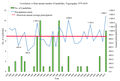 Correlation vs Rain annual number of Landslides, Tegucigalpa, 1979-2010.
 -
![Correlation number of landeslides vs Number Precipiation Monthly average and maximum, Tegucigalpa [2]](/images/thumb/4/49/SAT_deslizamientos_TGU-7.jpg/120px-SAT_deslizamientos_TGU-7.jpg) Correlation number of landeslides vs Number Precipiation Monthly average and maximum, Tegucigalpa [2]
Correlation number of landeslides vs Number Precipiation Monthly average and maximum, Tegucigalpa [2]


![Correlation number of landeslides vs Number Precipiation Monthly average and maximum, Tegucigalpa [2]](/index.php?title=File:SAT_deslizamientos_TGU-7.jpg)
-
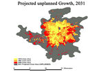 Projected Unplanned Growth, 2031
 -
![Project Planned Growth, 2031 [3]](/images/thumb/d/db/Projected_planned_growth.jpg/150px-Projected_planned_growth.jpg) Project Planned Growth, 2031 [3]
Project Planned Growth, 2031 [3]

![Project Planned Growth, 2031 [3]](/index.php?title=File:Projected_planned_growth.jpg)
Proposals for Climate Change Adaption
- How could your case study area become more resilient to climate change?
- Which measures would need to be taken to adapt to the new situation?
- How could you assure sustainability of these measures?
- Please describe 2-3 measures
Proposals for Climate Change Mitigation
- Which measures would need to be taken to reduce greenhouse gas emissions and other drivers of climate change within your case study area?
- How could you assure sustainability of these measures?
- Please describe 2-3 measures
Your scenario
- How will this area look like in 2060?
- Please forecast one potential future development taking climate change into account
Illustration: Map/diagram/sketches photos and background notes
What can be generalized from this case study?
- Are there any important theoretical insights?
- Which research questions does it generate?
- Short statement plus background notes
Image Gallery
-
 Downtown of Tegucigalpa, As shown in the picture, there's no landscape design in the river area which divides the city's downtown and historical center.
 -
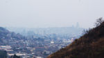 View of the topographical landscape of Tegucigalpa, deforestation on the hills and ground degradation, Photo by Fabricio Estrada
 -
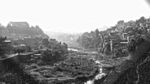 Panoramic View of River Area in Tegucigalpa, No landscape architecture involved in the River Area plus dangeorus proximity of houses in precarious state and no containing walls to protect from eventual floodings or landslides, Photo by Fabricio Estrada
 -
your image text
-
your image text
-
your image text
-
your image text
-
your image text


References
Please add literature, documentations and weblinks
- [6]
- [7]
- [8]
- [El Heraldo December 5 2011. https://www.elheraldo.hn/Secciones-Principales/Al-Frente/Cada-38-dias-el-gobierno-del-presidente-Porfirio-Lobo-emite-un-estado-de-emergencia]
- [La Prensa 26.10.2010 https://archivo.laprensa.hn/Pa%C3%ADs/Ediciones/2010/10/26/Noticias/130-000-familias-en-riesgo-por-clima-en-Tegucigalpa]
- [9]
- [Rapid Urbanization in Tegucigalpa, Honduras, Shlomo Angel with Katherine Bartley, Mary Derr, Anshuman Malur, James Mejía, Pallavi Nuka, Micah Perlin, Sanjiv Sahai,
Michael Torrens, and Manett Vargas, Princeton University, February 2004]
About categories: You can add more categories with this tag: "", add your categories