Group T - Collaborative Climate Adaption Project: Difference between revisions
| Line 298: | Line 298: | ||
[[File:CLIMATE_DATA.png]] | [[File:CLIMATE_DATA.png]] | ||
Image.34 General climate data | '''Image.34''' General climate data | ||
| Line 305: | Line 305: | ||
[[File:Climate_5.JPG]] | [[File:Climate_5.JPG]] | ||
Image.35 Daylight Graphic | Image.36 Daylight saving time | '''Image.35''' Daylight Graphic '''| Image.36''' Daylight saving time | ||
| Line 312: | Line 312: | ||
[[File:Climate_6.JPG]] | [[File:Climate_6.JPG]] | ||
Image.37 Sun Path | Image.38 Rainfall Data | '''Image.37''' Sun Path '''| Image.38''' Rainfall Data | ||
| Line 323: | Line 323: | ||
[[File:Cultural_features_5_copy_flood.JPG]] | [[File:Cultural_features_5_copy_flood.JPG]] | ||
Image.39 Flood I | Image.40 Furnitre turned to bridges I | Image.41 Furnitre turned to bridges II | '''Image.39''' Flood I '''| Image.40''' Furnitre turned to bridges I '''| Image.41''' Furnitre turned to bridges II | ||
| Line 330: | Line 330: | ||
[[File:Cultural_features_5_copy_flood2.jpg]] | [[File:Cultural_features_5_copy_flood2.jpg]] | ||
Image.42 Flood II | Image.43 Flood III | Image.44 Public response to flood | '''Image.42''' Flood II '''| Image.43''' Flood III '''| Image.44''' Public response to flood | ||
| Line 342: | Line 342: | ||
[[File:Cultural_features_5_copy_map.jpg]] | [[File:Cultural_features_5_copy_map.jpg]] | ||
Image.45 Current and future scenarios of Green-Blue ratio | '''Image.45''' Current and future scenarios of Green-Blue ratio | ||
=== Analysis of vulnerability === | === Analysis of vulnerability === | ||
Revision as of 23:13, 13 January 2013
| Area | Amman | |||||||||||
| Place | Amman | |||||||||||
| Country | Jordan | |||||||||||
| Topic | ' | |||||||||||
| Author(s) | Miguel Rasha and Azadeh | |||||||||||

| ||||||||||||
| {{#widget:GoogleMaps | width=300 | height=200 | lat=31.971095 | lng=35.908813 | zoom=12 | centermarker=yes | maptypecontrol=yes | overviewmapcontrol=yes | largemapcontrol=yes | scalecontrol=yes
}} | ||
Rationale: Why have you selected this case study area?
Back in 1920, Amman was a settlement that started on the edges of a water source RAS AL AIN stream. The lands surrounding the stream were rich with vegetation and trees. RAS AL AIN’s water source started from the current Downtown area, which spread towards the north east of Jordan. The stream aided the first settlers take on farming as means of sustenance. The city slowly expanded from the downtown area towards the hills, and with the expansion, the stream became a dumpsite, and slowly became a hazardous area. As the expansion continued, and the settlement was slowly turning into a city, more and more houses were built over the rich farming soil, instead of expanding the city towards the desert, and turning towards agriculture, and as a result, thousands of trees were cut down, to make way for buildings and streets, disregarding the need for open public spaces, and sustaining the existing vegetation. During the 1960s & the 1970s, Greater Amman Municipality embarked on implementing the first urban plan created for Amman, the capital city of Jordan, where various important decisions were made; the most important being, covering the stream by building a main street over it, and also, cutting down trees from various areas, such as the current site of Jordan University.
During the 1980s, the old quarter of Amman became an area highly congested with traffic, pollution, and demographic density. The area continued expanding, not by means of organized urban planning, but through urban sprawl, which affected the speed through which climate change hit the area even more. Within the past 20 years, the city’s climate changed rapidly, where instead of having four seasons in a year, there are currently only two: summer and winter. Desert storms became an annual event, whereas 30 years ago, it was a rare happening. Lands suffer from desertification and water resources, mainly rainfall levels are decreasing. However, Amman has great potentials in harvesting solar energy, as the area is sunny during ¾ of the year.
Our main focus will be identifying the major problems, realize the major opportunities in order to come up with strategies to improve the current situation, and adapt to or mitigate climate change effects on the city of Amman.
Authors' perspectives
In our point of view, Amman has too much potential to facing the future climate changes. During our research about the city we conclude that Amman is not very adapted at the moment and they need a deep reconfiguration of the city structure and the citizen habits too. There is a huge potential relating to sun energy. The city and the all country is heating exponential and concerning that, it can be a dangerous situation to deal with the global warming but at the same time, can also be a good factor that must be studied deeply. We feel that there is a massive lack of ecological features in the city. The vegetation is poor and in small amounts, the old river Ras al ain is completely buried, the city is growing in the direction of the farmlands and the concrete is getting more and more territory. One of ours concerning about Amman is the current social and economic situation. We believe that must be one of our tools along our study case. How can we take advantage of the climate in Jordan without big investments? How can we improve the energy consume with a lower budget? This topic is very sensible for the city of Amman and therefore it’ll certainly be a part of our work.
Landscape and/or urban context
| Biogeography |
The original site of the city occupied seven hills around the Wadi Amman, which flows north-east from the plateau towards the River Zarqa basin. The central part of the city is at an altitude of 725-800 meters. Expansion of the city in the past twenty-five years has resulted in the settlement of nineteen hills in total with an altitude of above 875 meters. The topography of the city consists of a series of steep hills and deep and sometimes narrow valleys. Most of the districts of Amman take their names from the hills on which they are situated. The initial development was principally on the upper slopes and crests and the lower slopes of this hill-valley system, the increase in urban development over the last sixty years has involved extensive development on the frequently steeper mid-slope locations.

Image1. General Location of the city of Amman
| Cultural Features |
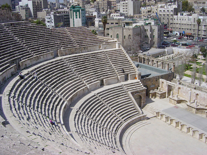
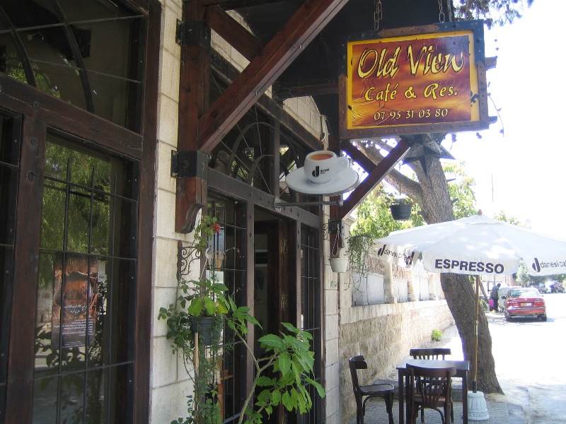
Amman is known of the national heritage, mainly consisting of ancient ruins from the Roman to the Abbasid times. The Roman theater, the Roman Nymphaeum, and Amman Citadel are the major national heritage and cultural symbols, as well as mosques constructed during within the first half of the 20th century. Certain structures, such as the royal court and the 10 bridges constructed also during the Roman reign remain the most important cultural symbols. The city of Amman has no opera houses, nor great museums or libraries, whilst within the second half of the 20th century, movie theaters were highly popular. Some of the older movie theaters still exist, however they have highly deteriorated and they're currently associated with taboo activities, such as illegal pornography screening, as well as prostitution locations. The current cultural reference of Amman could be described as underground, whereas street and cafe culture are the most prominent, which is usually parallel to the residential level. The cultural scene is mostly underground, and there is a boom in small businesses, where people tend to buy and renovate older structures and transform them into coffee houses or small galleries as well as smaller gatherings for the creative portion of the society.

Image.2 Roman Theater, location: downtown Amman | Image.3 Amman Citadel, Location: Jabal Al-Qala'a | Image.4 The Temple of Hercules, Location: Jabal Al-Qala'a

Image.5 The Raghadan Palace, Location: Downtown Amman | Image.6 Cafe culture, Location: Jabal Amman

Image.7 Cafe Culture, Location: Rainbow Street | Image.8 Street Culture, Location: Rainbow Street | Image.9 Cafe & Art culture, Location: Jabal Amman
| Planning |
The Greater Amman Municipality has recently initiated a new metropolitan growth master plan where developments would be finalized by the year 2025. "The metropolitan growth plan reflects the following planning and development principles:
- Encourage compact urban growth in order to make the best use of
existing services, promote increased transit use, improve pedestrian accessibility, and improve affordability for both the Greater Amman Municipality (GAM) and its residents.
- Direct growth to both existing built-up areas, in order to make the best
use of existing services, and to new designated expansion areas that are located close to the urban core.
- Promote mixed land use in general, and a mix of residential and
employment uses in particular, in order to foster a diverse economy and to limit commuting times.
- Promote clear distinctions between urban, suburban, and, traditional
communities in order to protect valuable environmental and agricultural lands and to support traditional lifestyles and culture.
- Focus GAM’s transportation policy on moving people and goods rather
than moving vehicles.
- Promote public transit and develop a transportation system that offers
choice.
- Provide for a safe and convenient pedestrian environment that is
integrated with other modes of transportation.
- Conserve the cultural heritage of the City, including modern and
ancient heritage.
- Create a connected Natural Heritage System that protects and
connects important environmental features - forests, wadis, highlands, deserts, and water aquifers - at the same time as it accommodates a network of public walking trails and urban parks throughout the City." (1)
The areas of the city included within the metropolitan growth plan include:
- Primary Growth Areas: Settlement Areas, Employment Areas, Metropolitan Corridors, and Metropolitan Growth centers. The Urban Envelope,which includes the existing core built-up areas of Amman and extends beyond them in designated areas to align with the Amman Development Corridor. This Urban Envelope will contain 85 percent of Amman’s new growth.
- Limited and No Growth Areas: Limited and No Growth Areas include Natural Heritage Areas, Cultural Heritage Areas, Agricultural Areas, and Mining and Quarry Areas where development is limited or prohibited. The natural heritage system includes features that are located on lands with difficult terrain and poor shallow soil.
In general, the quality of the City’s natural system is severely degraded and presents many opportunities for enhancement. The main goal is to protect environmentally sensitive areas such as including key watersheds, valleys,wildlife areas, and forest areas from development, incorporating the following: . Forests: including both natural forest areas and plantations. . Rehabilitated and\or Restored Sites: including quarries, other extraction sites, wadis, and steep slopes. . Major Wadis: including a 30 meter buffer surrounding the valley. . Significant Physical Features: including ridges and severe slopes . Mining and Quarry areas: Amman was fundamentally a mining town, built out of the stone quarried from the surrounding hills of the original settlement. Amman’s architectural character is defined by this relationship between the built environment and the skilled transformation of the sources of its urban fabric. In keeping with Amman’s distinctive urban form, quarrying and, to a lesser extent, mineral extraction will continue within the Metropolitan Planning Area, ensuring that Amman continues to be built out of local resources using local craftsmanship. With respect to mining and quarries, the MGP will:
Agriculture: The main goal is to Protect and conserve valuable agricultural resources, especially high quality rained agricultural land, and also to reduce agricultural water use and improve water quality for agriculture, as well as support and facilitate urban agriculture, increased water harvesting, and conservation, ensure compatible uses in areas adjacent to agricultural land and encourage high value-added economic and environmentally sustainable agricultural production such as organic farming.
 Image.10 Greater Amman Municipality boundary | Image.11 Built up areas and planned building expansion | Image.12 Natural Soil distribution
| Overall character |
Amman has become a more congested city in which it is increasingly difficult to drive, and through which it is almost impossible to walk. Reflecting its uncontrolled and uncoordinated growth, the city does not have an integrated public transport system. However, it is estimated that only 30 per cent of Jordanians use public transport, and these are generally the relatively poor. The dominance of the automobile is also reflected in the city’s network of major roads and tunnels, which grew phenomenally from the late 1960s into the 1980s, as the city expanded. Two new urban transport projects, the Abdoun Bridge and the Amman-Zarqa light railway project attest to the growing need to tackle the urban transport problem and at the same time support.
When thinking about water, Amman receives around 50 per cent of its water from the Jordan Valley. Water is pumped from –225 m in the Jordan Valley to a modern treatment plant at Zai to the north-west of the city at an altitude of 1035 m. The remaining water demands of Amman are met from the Al-Mafraq well, the Azraq aquifer (some 70 km east of Amman), as well as from Qatrana, Swaqa and Wala to the south of the city. Unlike many cities in the developing world, 98 per cent of households in Amman are connected to the water supply network.
Amman is well knows of it's local small businesses, where the government has no or limited input on the city's economic growth. The city's urban city-scape is known of it's mused use buildings, where street shops and cafes create the public sphere of the city, as major governmental and public institutions have a minor role in the city's economic growth.
| History & Dynamics |
Amman was named after the Ammonites who originally ruled the area which makes-up the present-day city. In 1200 BC, Amman was an urban settlement. A series of occupations followed, by the Assyrians, Babylonians, Persians, Greeks, Romans and Muslims. In the 1860s, under the rule of the Ottomans, Circassian tribes, Muslims escaping religious prosecution from Russia, settled on the ancient site of Amman, especially around the seasonal stream that flows in an east to west direction. Their livelihood depended on cultivation on both sides of the stream. The next major development came with the construction of the Hijaz Railway in 1902. This linked Amman directly with Damascus in the north and Medina in the south. The first Municipal Council of Amman was established in 1907, at which time the settlement consisted of little more than 300 families. In 1921, Prince Abdullah declared Amman the capital of the new state of Trans-Jordan and from then onwards, the city became the administrative and economic hub of the country. The development of the city was parallel to the political development of the country. Amman since 1907 has largely reflected wider political and geo-political circumstances. Thus, the area continued to attract migrants and its political stability led to successive waves of migrants joining the city from Syria, Palestine, Lebanon and the newly formed Iraq. Other religious and ethnic minorities, such as the Kurds and Armenians also came to live in the city. Throughout this period, Amman was also the focus of domestic migration. The main factor promoting migration to Amman city has been its status as the seat of government. People looking for a job in the public sector moved to Amman creating a “rent seeking mentality” which still dominates the behavior of the political economy of the country.

Image.13 Historic table
| Land-use patterns |
Plots designated as Category A have an area of at least 900 sq metres and the distance between the house and the boundary of the property must be at least 5m at the front, 7m at the back and 5 m from either side. The built-up area should be no more than 39 per cent of the plot, leaving space for ‘green’ areas. As shown in Figure 3, Category A residential land is almost exclusively located to the west of the Madeenah or city centre. The area forms a clear sectoral zone extending from around 1.5 km west of the city centre, out to the boundary of the Greater Amman Municipality (GAM). There is a secondary cluster to the north of the city and a few plots to the south of the city. The Hoytian-sectoral nature of this high-status residential zone is clearly revealed in Figure 3. Photograph 3 shows an opulent new build typical of the residential area of Abdoun to the west of the city centre.
Category B residential plots are between 750 and 900 sq m, with the house being more than 4m from the front, 6m from the back and 4 m from the sides. The built-up area of the plot can be up to 45 per cent. Although overall category B residential plots are more dispersed that category A plots, their remarkable concentration to the west of the city centre testifies to just how marked the divide is between the west and east of Amman.
Taken together, category A and B residential lands occupy the entire western and northern parts of the city, reflecting larger residential plot sizes, more substantial buildings and higher overall levels of wealth and social status. In category A and B lands, residential taxes are higher, and urban services such as street cleaning and water supply are more regular than elsewhere.
In contrast, category C land denotes plots of around 400 sq m, with residential buildings occupying up to 51 per cent of the plot. Houses must be no nearer than 4m of the front and back of the plot and 3m from the sides. It is noticeable that such residential plots are located throughout the city, including both the southern and eastern portion of the urban area (Figure 5). If the pattern is examined in detail, there is a broad zone of category C residential land encircling the Madeenah or central city, plus two broad sectoral wedges extending to the south and a cluster toward the western edge of the GAM.
Finally, category D describes smaller residential plots of up to 200 sq m, with a maximum permitted built-up area of 55 per cent. The residential building should be no nearer than 3m, 2.5m and 2.5m of the front, back and sides of the plot respectively. It is noticeable that category D residential lands characterise the inner city, extending in a broad belt around al-Madeenah (Figure 6). Particular concentrations are noticeable to the south and east of the downtown area, as shown in Figure 6. This also shows two large areas to the southeast of the city centre in the district of Al Qwaismeh, and these include the Palestinian camp of Al-Whedat just to the south-east of the urban core.
In terms of the intra-urban location of jobs within the city, a number of spatial nodes stand out. These include the combined Abdali area, plus the old bus and taxi depot and the western entrance to the city with 8,154 enterprises, Al-Qwaismeh (7258 enterprises), Wadi es Sir (7256), the downtown area (7095) and Tla’ Ali (7019) to the northwest. Once again a generalized west-east split emerges, with the western parts of the city housing the city’s most modern shopping centers, universities, hotels, sports stadia and other amenitites.

Image.14 Metropolitan Corridor distribution | Image.15 Mining query distribution | Image.16 National heritage network

Image.17 Open space network | Image.18 Natural Heritage Network

Image.19 Residential Landuse growth | Image.20 Past City Expansion plan

Image.21 Amman Metropolitan Growth Master Plan | Image.22 City expansion concepts | Image.23 City growth area designation
Cultural/social/political context
| Culture |
Eastern Amman (which includes Downtown) is home to the urbanized poor: it’s conservative, more Islamic in its sympathies, and has vast Palestinian refugee camps on its fringe. Western Amman is a world apart, with leafy residential districts, trendy cafes and bars, impressive art galleries, and young men and women walking openly arm in arm. The upmarket district of Shmeisani is referred to by locals as ‘Shiny Amman’ while the Abdoun area sometimes, is called Paris. This picture of two different realities in Amman reflects the concentration of relatively wealthy socio-economic groups to the west and also the north of the city. This pattern is associated with the early growth of Jabal Amman to the immediate west of the downtown as the wealthy quarter. With the growth of the city, the high-status sector has extended westwards from the city centre. Consequently, higher land prices have always characterized this sector of the city and the high-income districts of Amman are growing outwards to the north-west in a sectoral wedge-shaped pattern. Thus, today the western part of the city exhibits relatively low population densities. i
The residential land within Amman is divided into four categories. These categories are based on the criteria of minimum plot size, the maximum percentage of the plot that can be built upon, and the distance between residential buildings and the boundary of the plot.

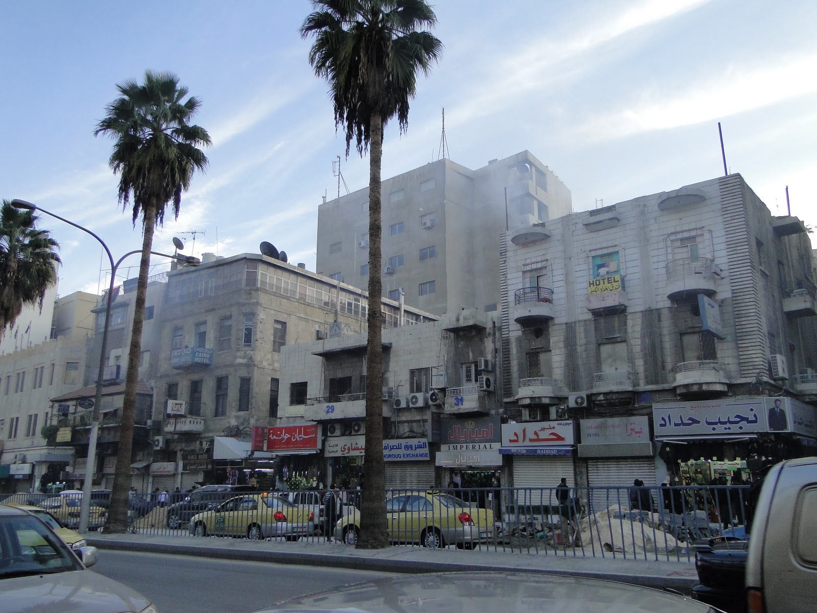
Image.23 Downtown Amman, Location: Saqf Al-Seil street | Image.24 A view on East Amman

Image.25 West Amman, location: Abdoun | Image.26 Downtown Amman, Location: Faisal street

Image.27 West Amman, Location: Shmeisani, Culture street | Image.28 West Amman, Location: Business district
| Political economy |
Amman is the main economic center of the Kingdom. More than 80 per cent of all industrial and service activities are located in Greater Amman together with the industrial suburbs and peri-urban zone toward Zarqa and the north-east. General levels of prosperity and incomes are higher in the capital than elsewhere in Jordan. The average income of Ammani households was 6533 JD per year, while the national figure was 5590 JD. In comparison, the average annual income for all urban households throughout Jordan is lower than 5590 JD.
The main employment categories in Amman are wholesale and retail trade plus the repair of vehicles and personal and household goods. Amman is dominant in terms of the national tourism sector, with 75.2 per cent of all direct employment in the sector being located in Amman. Likewise, over two-thirds of all hotel beds in Jordan are located in Amman.
| Legal framework |
The Greater Amman Municipality is responsible for giving agreements, as technical review of the detailed plans by GAM representatives is necessary before issuing a construction license, which leads to a development agreement that includes terms, conditions, requirements, obligations, and responsibilities of all parties in association with a Project. The content of a development agreement usually includes conditions of approval from the design review process, capital improvement charges for services, roads and transportation, storm water drainage, open space acquisition fee, purchase of development rights fee, off-site construction completion by both the developer and the municipality.
If a change in building and construction and also infrastructure regulations are needed, the approval needs to come from the Prime Minister of Jordan. One such example is the Abdali development, where various regulations were broken or changed, such as setbacks, building height, and access to infrastructure such as streets, water drainage system, and landuse. Where a massive central business core is designed in a residential area, causing future worries of traffic congestion, lack of liquid waste management causing sewer floods within the entire surrounding area, as well as lack of clean water provision, not to mention threats of increasing pollution rates.

Image.29 National Policies and Agenda table

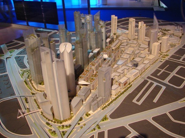
Image.30 Abdali Development Project 3D Model, Location: Abdali | Image.31 Abdali Development Project 3D Rendering, Location: Abdali

Image.32 Abdali Development Project 3D Rendering II, Location: Abdali
Local Climate
| Local Climate |
Amman has a relatively wet rainy season between November and April, while the rest of the year is usually dry, as Amman is located within the upland Jordan Plateau. Spring and autumn are of a relatively short duration, Summer, extending from late May through to much of September, is a rainless periodThe spring (parts of April and May) and autumn (parts of September and October) have temperatures ranging from 23 temperatures ranging from 28oC to 32 oC to 27 C. and characteristically low humidity and frequent breezes. The winter period (from November through to early April) has night-time temperatures close or below zero, and snow occurs on occasion, particularly in December and January. Day-time temperatures during this period average between 12 oC and 21 oC. Winter rainfall is in the region of 300mm annually, normally with the highest amounts in January and February. However, in the recent years, the amount of rainfall has gradually increased, and the chance of snowing increased annually from one time to two or three times a year.

Image.34 General climate data

Image.35 Daylight Graphic | Image.36 Daylight saving time

Image.37 Sun Path | Image.38 Rainfall Data
In January 2013, Amman suffered a massive storm, where the rainfall amounts exceeded the usual rates and caused major floods all over the city. The infrastructure deficiency came to surface as Jordan faced major rainfall and subsequently massive snowfall during a span of one week. During the latest storm, the government had no equipment to drain and excess water, which caused various problems within the street structure, paving, electricity poles, and the drainage and sewage system. The people of Amman responded to the government's reaction through humor, while may communities formed help groups to aid those in need.
Of course, linking this catastrophe with the current political structure, after this natural phenomenon, there was a satire movement criticizing politicians for their lack of interesting in environmental studies.

Image.39 Flood I | Image.40 Furnitre turned to bridges I | Image.41 Furnitre turned to bridges II

Image.42 Flood II | Image.43 Flood III | Image.44 Public response to flood
| Future Climate Changes |
Climate change will have a major impact on Amman as droughts and flooding are major natural hazards to be concerned of. Jordan has scarce water resources, and relies mainly on groundwater. This is not sustainable as almost 90% of the available water reserve is used. The quality of Amman’s air has not been systematically measured, and there are numerous sources of emissions within Amman, however little data exists, making it difficult to determine the key polluters, and where efforts should be directed to minimize pollution. The future predicts a general increase in temperatures all over Jordan reaching up to 4 oC, as well as reduced precipitation up to 20%, and unknown impacts on groundwater. Another issue facing Amman in the future is the threat of the increase of dry lands, and magnification of the effects of sandstorms coming from the east. However, there is no real evidence on the aforementioned future climate predictions, as there haven't been serious measures dedicated towards climate change issues.

Image.45 Current and future scenarios of Green-Blue ratio
Analysis of vulnerability
When considering the future climate changes, various aspects of the city should be considered. The most important aspect is the environmental and sustainable planning; a new master plan that would address the pollution rates in the congested areas of the city, where cleaning these areas from polluting agents must take a priority before addressing the building standards and land use within these areas. However, this process should also take even greater lengths through raising awareness for zero emission vehicles and transportation, pedestrian movement, and general street hygiene. Another measure that could be planned is the utilization of rooftops, in a manner that would generate profit to the building owners, as many of East and central Amman residents are impoverished, and in major need for improved livelihood. The current infrastructure is a major setback in any future project, as the current state of the infrastructure renders it as incapable of absorbing the current city load. One major aspect of the infrastructure is storm water drainage network, sewage system, and underground water reservoirs. A huge portion of the annual rainfall is lost, due to infrastructure deficiency, and this must be addressed. Planning greenbelts on the dry borders of the city is a must, as currently sandstorms create a major risk, not only in polluting the air, but also increasing the rates of desertification on the easters outskirts of the city. The slope should be addressed in a studied manner, so as to completely utilize it for directing the rain water flow.
The major threat for implementing any strategies are the current political and national policies, as the political status of the country is still unstable, due to political corruption, social segregation, and financial problems that the Greater Amman Municipality is facing, as within the past few months, it has declared it's bankruptcy, due to lawsuits raised against them for illegal land purchase.

Image.46 SWOT Analysis
Proposals for Climate Change Adaption
- How could your case study area become more resilient to climate change?
- Which measures would need to be taken to adapt to the new situation?
- How could you assure sustainability of these measures?
- Please describe 2-3 measures
Proposals for Climate Change Mitigation
- Which measures would need to be taken to reduce greenhouse gas emissions and other drivers of climate change within your case study area?
- How could you assure sustainability of these measures?
- Please describe 2-3 measures
Your scenario
- How will this area look like in 2060?
- Please forecast one potential future development taking climate change into account
Illustration: Map/diagram/sketches photos and background notes
What can be generalized from this case study?
- Are there any important theoretical insights?
- Which research questions does it generate?
- Short statement plus background notes
Presentation Slides
-
Slide One
-
Slide Two
-
Slide Three
Image Gallery
-
your image text
-
your image text
-
your image text
-
your image text
-
your image text
-
your image text
-
your image text
-
your image text
References
Literature:
Abu-Dayyeh, N (2004a): ‘Persistent vision: plans for a modern Arab capital, Amman, 1955-2002’, Planning Perspectives, 19, 79-110
Al-Asad, M (2004a): ‘Public transportation’, Jordan Times, 27 May 2005
Amman Municipality (1987): Greater Amman Comprehensive Development Plan 1985-2005, Amman. Jordan
Amman Municipality (2007): Metropolitan Growth Plan 1985-2005, Amman. Jordan
Razzaz, O M (1996): ‘Land conflicts, property rights and urbanization east of Amman’.
Rosenberg et al (2008) Water International. “Intermittent water supplies: challenges and opportunities for residential water users in Jordan.”
“Green City” Approach from Freiburg, Germany to Amman, Jordan. (11- 15 September). A brief on Amman Institute / Greater Amman Municipality Delegation To Freiburg, Germany
FOOD SECURITY AND CLIMATE CHANGE IN DRY AREAS. Presentation by The National Center for Agricultural Research and Extension (NCARE), the Ministry of Agriculture of Jordan and The International Center for Agricultural Research in the Dry Areas (ICARDA)
Ammar Gharaybeh. City Manager, Greater Amman Municipality. May 2009. Innovative Climate Change Initiatives in Amman, Jordan. Cities Climate Change and Finance & Carbon Expo. Barcelona, Spain.
The Evolving Arab City: Tradition, Modernity and Urban Development (Planning History and Environment). Edited by Yasser Elsheshtawy. 2011.
Robert B. Potter, Khadija Darmame, Nasim Barham, Stephen Nortcliff. 2007. An Introduction to the Urban Geography of Amman, Jordan.
Omar Maani, Mayor of Amman. 2007. High Rise Towers: An Integral Part of Amman’s Urban Landscape.
Greater Amman Municipality. 2007. Amman Master Plan PMU. Interim growth strategy. High density mixed use development manual.
Web:
http://jordantimes.com/hurricane-wadha-becomes-comedy-fodder-on-social-media
http://www.gaisma.com/en/location/amman.html
http://www.venture-mag.com/index.php/opinion/postscript/item/169-amman-a-tale-of-one-city.html
http://www.eco-web.com/reg/04441.html
http://ascelibrary.org/doi/abs/10.1061/%28ASCE%29WR.1943-5452.0000172
http://dapa.ciat.cgiar.org/climate-change-in-dry-areas-the-amman-declaration/
http://ascelibrary.org/doi/abs/10.1061/%28ASCE%29WR.1943-5452.0000172
http://ammanvoice.blogspot.com/2007/11/more-abdali-high-rise-buildings-more.html
http://en.wikipedia.org/wiki/Semi-arid_climate
http://www.ammancity.gov.jo/en/gam/index.asp
www.vista.sahafi.jo/art.php?id=5c192f82b0e48f7cf98ce818d14c76839c27d4cb
http://www.undp-jordan.org/index.php?page_type=projects&cat=3&page_id=387
http://www.weatheronline.co.uk/reports/climate/Jordan.htm
http://www.artterritories.net/designingcivicencounter/?page_id=78
http://www.ammancity100.jo/en/content/story-amman/1930s
Image gallery:
Robert B. Potter, Khadija Darmame, Nasim Barham, Stephen Nortcliff. 2007. An Introduction to the Urban Geography of Amman, Jordan.
Omar Maani, Mayor of Amman. 2007. High Rise Towers: An Integral Part of Amman’s Urban Landscape.
Amman Municipality (2007): Metropolitan Growth Plan 1985-2005, Amman. Jordan
http://3.bp.blogspot.com/_RUVV1mvn6wk/R0_qOmaPI1I/AAAAAAAAAY0/RlTGrSIVIC0/s1600-R/Abdali.jpg
http://www.gaisma.com/en/location/amman.html
http://en.wikipedia.org/wiki/Amman
http://wanderlustmuslimah.files.wordpress.com/2012/02/weibdeh.jpg
http://cache.virtualtourist.com/4/6318356-Al_Hashemi_St_Downtown_Amman_Dec_2010_Amman.jpg
http://4.bp.blogspot.com/_By3kCN3q21w/TRD5hv2msoI/AAAAAAAAAIw/MngfWg9jwx8/s1600/DSC01338.JPG
http://www.jordanienonline.de/img/pho/culture/shmeisani4_culturestreet.jpg
http://www.sit.edu/Images/ssa_images/phot_joi-SIT-Jordan-Center-from-roof.jpg
http://farm1.static.flickr.com/149/399918151_142935ef0f_o.jpg
http://a2.ec-images.myspacecdn.com/images02/114/364e466b7bf549cdac9bdd8e43d60d43/l.jpg
http://www.geographylists.com/jordan_amman_citadel_ruins.jpg
http://jordanamman.net/images/amman/Amman-The-Citadel.jpg
http://upload.wikimedia.org/wikipedia/commons/2/25/Amman_Roman_theatre.jpg
http://www.yourmiddleeast.com/media/news/images/2012/photo_1337190689025-1-0.jpg
http://thelevantpost.com/wp-content/uploads/2012/06/rainbow-street1.jpg
http://static.flickr.com/92/219700633_01d126744f_o.jpg
http://www.jordanjubilee.com/images/outdoors/xwildjordan_coffeeshop.jpg
https://fbcdn-sphotos-b-a.akamaihd.net/hphotos-ak-snc7/312334_396346723780809_624094729_n.jpg
https://fbcdn-sphotos-f-a.akamaihd.net/hphotos-ak-snc7/299685_317252465053788_1468877856_n.jpg
https://fbcdn-sphotos-d-a.akamaihd.net/hphotos-ak-ash3/734093_143774202445013_807430646_n.jpg
http://www.atlastours.net/jordan/amman_panorama.jpg
http://www.360east.com/wp-content/digital-city1.jpg
https://www.healthbase.com/hb/images/countries/Jordan/jordan_downtown_amman.jpg
http://www.khaberni.com/more.php?newsid=90431&catid=1
http://4.bp.blogspot.com/_By3kCN3q21w/TRD5hv2msoI/AAAAAAAAAIw/MngfWg9jwx8/s1600/DSC01338.JPG
http://www.architecturalpapers.ch/images/articles/69_6_w1000h600.jpg