Planting Design 2013 - Working Group 5: Difference between revisions
Amani.majid (talk | contribs) |
|||
| (8 intermediate revisions by 2 users not shown) | |||
| Line 26: | Line 26: | ||
<gallery caption=" " widths="150px" heights="150px" perrow="4"> | <gallery caption=" " widths="150px" heights="150px" perrow="4"> | ||
Image:Slide1 group 5.JPG|slide 1 | Image:Slide1 group 5.JPG|slide 1 | ||
Image:Slide2 group 5.JPG|slide 2 | Image:Slide2 group 5 Slide 3 group 5 Assignment 3.JPG|slide 2 | ||
Image: | Image:Slide 3 group 5 Assignment 3.JPG|slide 3 | ||
</gallery> | </gallery> | ||
| Line 40: | Line 40: | ||
<gallery caption=" " widths="150px" heights="150px" perrow="4"> | <gallery caption=" " widths="150px" heights="150px" perrow="4"> | ||
Image:Slide1.JPG| | Image:Slide1 group 5 analysis.JPG|Analytical drawings | ||
Image:Slide2 group 5 projective | Image:Slide2 group 5 projective.JPG|Projective drawings | ||
Image:Slide3 group 5 design synthesis.JPG|Design synthesis | Image:Slide3 group 5 design synthesis.JPG|Design synthesis | ||
</gallery> | </gallery> | ||
| Line 49: | Line 49: | ||
[[Category: Planting Design 2013 Working Group]] | [[Category: Planting Design 2013 Working Group]] | ||
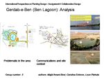
'''Analitical drawings''' | |||
Gerdab-e-Ben (Ben Lagoon) is a beautiful attraction of Iran and it gives the region where it is located a lots of potentials. | |||
Although Gerdab is an outstanding tourist region already (and was chosen for that in 2010), the area and it´s quality have a big potential for improvement, which would help to attract many more tourists as well. | |||
The main problems we found on the site after our analysis ware: | |||
-the heavy traffic around the lake (which make it seem more like a traffic turning point than an outstanding landscape and this can be nicely seen in the first picture on the slide where you have the yellow road surrounding Gerdab) | |||
-this can also be seen in the second picture which is an analysis of communications and site contex. The lines that are coloured yellow are the main communication directions within the town of Ben itself so they are left like they are whereas the red coloured lines represent the road directions by the Gerdab lake and are something that needs to be changed. There are far to many roads surrounding Gerdab and this is a thing that could potentially be solved a lot better | |||
-the discontinuous tree lines on the eastern side of the lagoon and the disconnection between the green spaces of the lagoon and the city can both be seen in the last analytical picture | |||
-the lack of evergreen species and the wasted potential in the implementation of new residential areas are also some problems that were analysed | |||
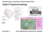
'''Projective drawings''' | |||
The main goals of our collaborative planting design of Gerdab-e Ben were: | |||
-to improve the overall condition and planting scheme of the site´s green areas | |||
-to move the position of the road surrounding Gerdab | |||
-to analyze the existing facilities on the site and rethink their meaning, position, actual funtion and contribution to Gerdab | |||
-to introduce new residential areas (with their additional elements) | |||
-to make this outstanding (and someone´s everyday) landscape more “natural“ and “people friendly“ and as pleasant as it can be thus more attractive, unique, interesting and representative for both Ben´s residents as well as Gerdab´ visitors | |||
First sketch on the left represents a conceptual zoning and in it the position of the main road has moved and smaller additional roads around Gerdab were cut out so as a side effect a big surface aveilable for planting and new residential areas was gained. Children´s playground, recreational zone, open air theatre next to a museum and an aromatic park are just some new features of Gerdab´s surroundings. | |||
The lower picture on the right shows another approach that kept a lot of existing aspects Gerdab has now, but also introduced new ones: pathways, a botanic garden, sports grounds, a museum and a modern game world. | |||
The last sketch on the upper right side shows how could a new solution function with an underground garage being a part of it. By putting parking underground more space would get green above the ground and that is an ideal concept of something that is both aesthetical and functional. | |||
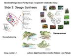
'''Design synthesis''' | |||
The main criteria for drawing this conclusion was really a fusion of everything that has been done previously. Through discussion the best parts of each idea were taken and thus the final proposal was made. | |||
First sketch on the right shows a new zoning that now has a second road in the cental part of the site due to the needs of facilities that are going to be intoduced (open air theatre, museum). This is also the road that leads visitors to the entrance of the undergound garage. The new residential areas are : New pedestrian and cycling pathways, Children´s playground, Museum, open air theatre, Sports grounds, aromatic garden, grill and leisure zone, artistic zone and informal residential areas. The one´s we kept are: sailing camp, supermarket, coffee shop and the gas station. | |||
On the upper left there is a concept of green structures visible along with its primary diagram and scheme in black and white. It is surrounded with pictures of plants that could potentially become a part of this site in the future and some of them are: Magnolia liliflora, Cercis siliquastrum, Picea pungens, Hedera helix, Juniperus horizontalis, Berberis thunbergii, Querqus brantii Lindl., Papaver spp... These were chosen with regards to the climate of the region. Their tolerance to cold winter and dry summer conditions was considered. The plants were chosen according to their type, growing form and flowering period. | |||
The last sketch on the slide shows perspective drawings of different residential areas on the site. The upper two sketches of the 4 included show future pederstian and cycling pathways along the woodlans area as well as the one beside the lake itself. The 2 lower sketches show a wooden deck on the water that can be used as a tool of a child´s play as well as an informal residential area on the left and a children´s playground on the right. The philosophy of the playground came out of Gerdab´s site context. As it is a lake that is situated between 2 mountains, the central part of the playground is consisted of 2 high mounds with slides and a treehouse that have a water feature (maybe a fountain) in between. In this way the playground is a conceptual duplicate of the site itself. | |||
Latest revision as of 10:16, 1 February 2014
--> Back to working group overview
Dear working group members. This is your group page and you will be completing the template gradually as we move through the seminar. Each member has an individual page for documenting his/her personal case. Good luck and enjoy your collaboration!
Assignment 2 - Lecture Concept Map
-
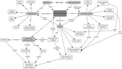 The group concept map of the lecture given by Paulo Ferinha Marques on November 27th 2013 - "The aesthetics of natural sucession"

Assignment 3 - Images of Nature in your Environment
- Assigned: Wednesday, October 30
- Due: Tuesday, December 3
An 'image of nature' can be any planting design or vegetation structure. It might be on a local scale in your direct vicinity or be a part of a wider landscape structure. Each group member finds an individual page here that links to a template. You can use this template for documenting your case.
Case Study A
Case Study B
Case Study C
Presentation Slides Assignment 3
-
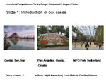 slide 1
 -
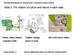 slide 2
 -
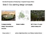 slide 3


Assignment 4 - Collaborative Planting Design
- Assigned: Wednesday, December 4
- Due: Tuesday, January 21
Collaborative Design Working Group 5
Presentation Slides Collaborative Design
-
 Analytical drawings
 -
 Projective drawings
 -
 Design synthesis


Analitical drawings
Gerdab-e-Ben (Ben Lagoon) is a beautiful attraction of Iran and it gives the region where it is located a lots of potentials. Although Gerdab is an outstanding tourist region already (and was chosen for that in 2010), the area and it´s quality have a big potential for improvement, which would help to attract many more tourists as well.
The main problems we found on the site after our analysis ware:
-the heavy traffic around the lake (which make it seem more like a traffic turning point than an outstanding landscape and this can be nicely seen in the first picture on the slide where you have the yellow road surrounding Gerdab)
-this can also be seen in the second picture which is an analysis of communications and site contex. The lines that are coloured yellow are the main communication directions within the town of Ben itself so they are left like they are whereas the red coloured lines represent the road directions by the Gerdab lake and are something that needs to be changed. There are far to many roads surrounding Gerdab and this is a thing that could potentially be solved a lot better
-the discontinuous tree lines on the eastern side of the lagoon and the disconnection between the green spaces of the lagoon and the city can both be seen in the last analytical picture
-the lack of evergreen species and the wasted potential in the implementation of new residential areas are also some problems that were analysed
Projective drawings
The main goals of our collaborative planting design of Gerdab-e Ben were:
-to improve the overall condition and planting scheme of the site´s green areas
-to move the position of the road surrounding Gerdab
-to analyze the existing facilities on the site and rethink their meaning, position, actual funtion and contribution to Gerdab
-to introduce new residential areas (with their additional elements)
-to make this outstanding (and someone´s everyday) landscape more “natural“ and “people friendly“ and as pleasant as it can be thus more attractive, unique, interesting and representative for both Ben´s residents as well as Gerdab´ visitors
First sketch on the left represents a conceptual zoning and in it the position of the main road has moved and smaller additional roads around Gerdab were cut out so as a side effect a big surface aveilable for planting and new residential areas was gained. Children´s playground, recreational zone, open air theatre next to a museum and an aromatic park are just some new features of Gerdab´s surroundings.
The lower picture on the right shows another approach that kept a lot of existing aspects Gerdab has now, but also introduced new ones: pathways, a botanic garden, sports grounds, a museum and a modern game world.
The last sketch on the upper right side shows how could a new solution function with an underground garage being a part of it. By putting parking underground more space would get green above the ground and that is an ideal concept of something that is both aesthetical and functional.
Design synthesis
The main criteria for drawing this conclusion was really a fusion of everything that has been done previously. Through discussion the best parts of each idea were taken and thus the final proposal was made.
First sketch on the right shows a new zoning that now has a second road in the cental part of the site due to the needs of facilities that are going to be intoduced (open air theatre, museum). This is also the road that leads visitors to the entrance of the undergound garage. The new residential areas are : New pedestrian and cycling pathways, Children´s playground, Museum, open air theatre, Sports grounds, aromatic garden, grill and leisure zone, artistic zone and informal residential areas. The one´s we kept are: sailing camp, supermarket, coffee shop and the gas station.
On the upper left there is a concept of green structures visible along with its primary diagram and scheme in black and white. It is surrounded with pictures of plants that could potentially become a part of this site in the future and some of them are: Magnolia liliflora, Cercis siliquastrum, Picea pungens, Hedera helix, Juniperus horizontalis, Berberis thunbergii, Querqus brantii Lindl., Papaver spp... These were chosen with regards to the climate of the region. Their tolerance to cold winter and dry summer conditions was considered. The plants were chosen according to their type, growing form and flowering period.
The last sketch on the slide shows perspective drawings of different residential areas on the site. The upper two sketches of the 4 included show future pederstian and cycling pathways along the woodlans area as well as the one beside the lake itself. The 2 lower sketches show a wooden deck on the water that can be used as a tool of a child´s play as well as an informal residential area on the left and a children´s playground on the right. The philosophy of the playground came out of Gerdab´s site context. As it is a lake that is situated between 2 mountains, the central part of the playground is consisted of 2 high mounds with slides and a treehouse that have a water feature (maybe a fountain) in between. In this way the playground is a conceptual duplicate of the site itself.