Transformation of the Meles Delta, Izmir, under the eco-city concept
| Name | Meeting at the Knot Point | |
| Place | Izmir | |
| Country | Turkey | |
| Author(s) | Isin Barut | |
| Project start | March, 2010 | |
| Completion | June 18, 2010 (student project) | |
| World Heritage | - | |
| Client | - | |
| Project costs | - | |
|
<googlemap version="0.9" lat="38.45211" lon="27.14756" zoom="13" width="400" height="300" controls="small"></googlemap> | ||

Rationale: Why is the case study interesting?
- Please summarise:- e.g. Design Innovation? Planning Exemplar? Theoretical Insights? Lessons from its failure?
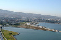
Meles delta is located in the heart of the Izmir gulf which has the second largest harbor of Turkey. The region of the delta is an industrial site of the city. The surroundings create a big economy but thereaten the delta ecosystem. So delta needs to be developped and survive itself. Furthermore becouse of being an entrance from the sea side it has to wellcome people with a quality design! All these kind of aspects lead to this project to transform the area to a better place for flora fauna and people. This project shows how the delta system meets with the city& dewellers and what are the ecological planning and design proposals to create a balance between utilization and preservation.
Author's perspective
- What theoretical or professional perspective do you bring to the case study? Please make a short note on your personal background
This project unities landscape planing, landscape design and urban planning . Landscape planning is the pioneer together with urban planning and later on landscape design solutions shapes the delta body and give hands to the inner city. The method is analysing the whole region and city in bigger scale, later on creating a stratey and concept. And after that detailing and visualising the landscape in smaller scale.
What makes this project different is showing how a special leftover delta landscape transform to a better place.
Cultural landscape context
- Biogeography, cultural features, overall landscape character, history and dynamics
Izmir city is a place where water meets the history and modernism. Its said that Izmir is the most modern face of Turkey. There are many clean beaches, many antique places and also many modern sites. People live in a peace here, its international that creates variety in culture.
İzmir is Turkey's third most populous city(3.868.308 people) and the country's second largest port city after Istanbul. It is located along the outlying waters of the Gulf of İzmir, by the Aegean Sea. It is the seat of the İzmir Province, which has an area of 7350 km2. The city of İzmir is composed of twelve metropolitan districts. all headed by the Mayor of İzmir. The central area of the city consisting of metropolitan districts has a total area of 855 km2.
The area was first settled by Ionian greeks in about the 11th century BC who established the city of Smyrna, now İzmir city. It was later conquered by the Persians, retaken by the Greeks, before being subsumed into the Roman Empire. After the split of the Roman Empire, the area became part of the Byzantine Empire until conquered by the Ottoman Turks in the 14th century.(Taşdemir, 1989).

Meles delta in 1950, Izmir

Meles delta in 1996, Izmir

Meles delta, 2010, Izmir


Map; sketches; short descriptive analyses
Socio-political context
- Brief explanation of political economy, legal framework
Bayraklı district where Meles delta belongs is a part of the harbour trade center. The delta is covered with a big trade zone which gives much importance to the area. Thats why it hosts architectural international competitions. Its obvious delta has a great potential since 2000's, but more than half of the delta is leftover...
There are some development projects of Izmir municipality. A big project called Izmir new city center reconstruction plan will be implemented in 10 years. Some social groups are rejecting this project becouse of the pressure on nature( for example the percentage of hard constructions is more than open green spaces). In addition the new plan is anticipating to create skyscrapers for mostly use of shopping centre in Bayraklı region. Development plan of the Izmir leaves some green open spaces around delta but the they are are not connected; further more high ways are creating huge barriers between greenery and city especially between Meles delta and Bayraklı district.
Discussions are still going on and prefessional groups are care about the delta ecosystem.
Illustration: Bullet points, image, background notes
Back to top
am
Spatial analysis of area/project
- What are the main structural features?
- How has it been shaped? Were there any critical decisions?
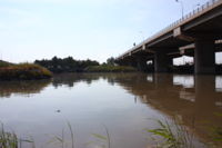
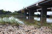
Famous historian and geographer Strabon((B.C. 63 – A.D. 23) had defined Meles delta: River Meles flows near by the city of Smyrna(mitological name of Izmir). Smyrna is great with many memorial and its harbour but it has a defection; the engenieers who furnished nice stones to the roads had forgotton to build sewage system... Becouse of this dirt cover to the roads especially on rainy days! (Ministry of Culture, 1993 Ankara)
For decent years Meles river has been have a function as a discharge canal for industrial and settlement contaminants becouse of missing infrastructure plan. Dirty sedimentation was covered approximetely 300.000 m2 triangle area in delta.(Ekinoğlu, 2001, İZSU 2001, 2003). This dirt pressure had coused a decrease of the oxygen in water systems and had made a poisoned swampy area in the whole gulf. The dirty mug, accumulated in Meles delta had producted methane gas which had threatened the natural habitat. Gas pollution creates bad smell in the whole region.
Izmir municipality and Goverment Water Works collobrated to create a sustainable solution for the whole gulfs rehabilitation. For Bayraklı region the dirty mug at the base of the river had removed and it was not completely successful. After that Izmir municipality implemented a rehabilitation project called Big Canal Project. The method of that project was embossing the dirty mug and let it meet with oxygen on the river surface. When its relaised that the mug is clear enough a geotekstil material was covered the delta to make the mug loose water. Big canal project used stones and clean soil on the top of geotekstil slab. And they growed grass at the top. For the gas protection gas chimneys were created to leave methan gas free to the atmosphere. Big canal project costs 4.5 million dollars, it successed a decrease of the smell pollution but it did not end! Meles delta is more liveable afer the Big Canal Project but it could not sustain the whole area. There is still bad smell problem in the Bayraklı district becouse of the dirty rivers.( Izmir meles deltası ıslah projesi, Türkay BARAN & Mehmet GÜLAY)
Analysis

Illustration: Map/diagram/sketches photos and background notes
Analysis of idea/program/function ("Planning Objective")
- What are the main functional characteristics?
- How have they been expressed or incorporated?
First of all we designated the critical areas of the region. And than realised the importance of the project. Later we overlayed main issues with critical points for the landscape assesment analysis. After that we created 3 strategies.
Planning Objectives are created with the responsibility of natural, historical and social aspects.
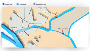
-Develop the natural resources( especially Meles, Arap, Manda rivers).
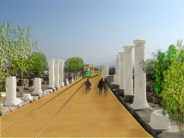
-Create access to the nearest hisrorical site located around Meles delta.
-Improve the pedestrian access with nature friendly transportation.
Main goal: Give power to the delta to survive itself! And create an identity!
Vision: Historical, social and ecological knot point.
Strategy: Create an ecological network, historical and social link at the Izmir harbour area.
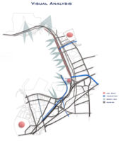
Connective elements: Open green spaces, bicycle roads, pedestrian roads, bridges, tram route, sea transportation, river transportation, communication network(descriptive maps, casts, signboards, advertisements).
Activities for network: Street festivals, art & ecology exhibitions, workshops and educational competitions.

New transportation system

Illustration: Map/diagram/sketches photos and background notes
Analysis of design/planning process ("Process Biography")
- How was the area/project formulated and implemented?
- Who initiated the project and why?
- Which stakeholders have been involved?
- Who made the major decisions and when?
- Were there any important consultations/collaborations?
This project concantrates on ecological network for scenarios and shows how we want to see the Meles river after 10 years and than we focus on Historical and social links for detailing and visualising.
Design objectives: Less damage to the nature, monolith design, simplicity forms, colorful landmarks, stress the knot motto.
The design solutions are created for both nature and city dewellers. After this project we suppose this area will be sub city center of Izmir. The design solutions mostly enhance the natural water system, but as and landscape architects to survive the ecological values is a professional principle. We tried to touch less the nature but did not completey created an untouchable area becouse of natural education especially for childs.

Design process
Redesigned river site


Illustration: Map/diagram/sketches phoalisingbackground notes
Analysis of use/users
- How is the area/project used and by whom?
- Is the use changing? Are there any issues?
This project did not end and implemented but we want Meles delta will adress for the every age group who should have the consciousness of ecology and metropolitan affects on it. Our strategies are not directly for tourism but for the economical input and maintance of the area we offer touristic uses either, ofcourse with some protection issues like closing the delta at the birds breeding periods.
The use of the delta is changing parallel with the landscape change, nowadays its mostly used for picnic by the Bayraklı region, generally people visit Meles delta at the weekends. The area is not a really hot spot to visit. There are some greenery, a lost wet land, pedestrian road, children playground, a small lake nowadays.
Slowy delta will be started to attract birdwatchers and naturalists too. We want to improve the identity more about natural wetland facilities. Nature always help people to relax if its an healty nature. So Meles Delta is heading to a relaxing place for everybody.
Illustration: Map/diagram/sketches photos and background notes
Future development directions
- How is the area/project evolving?
- Are there any future goals?
The project is evolving step by step one of the main goal is the connecting the city with whole delta system. It was reflected by creating transportation connections but also stressed by linking green open spaces and river transportation. The evoluation is more about wetland system which was enlarged.
After having the results of new design solutions the interest groups will directly be changed. The new quality landscape will increase the variety of interest groups. We want people to educate themselfs about natural habitat here and realise how they need this kind of natural places between metropolitan sites!
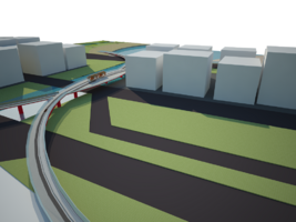
New pedestrian bridge and the new tram way

Illustration: Map/diagram/sketches photos and background notes
Peer reviews or critique
- Has the area/project been reviewed by academic or professional reviewers?
- What were their main evaluations?
Meles delta has been an interesting issue for academic people both in Izmir and in other cities. People pay attantion to this area becouse if its ironic landscape. May be it would not be as famous as todays even if it were not located in the hearth of the city. It is an ironic becouse its not completely natural its also manmade cultural landscape but people who generetad a project to make landfills in the delta could not achive a good performance to create a sustainable delta.
Landscape architects,architects, urban planners, biologists care for the area and the district it belongs. We had the critics of urban planners and landscape architects. Urban planners generally think there is no big problems in this region, they find New Izmir city development plan good enough, becouse of thinking on a bigger scale than landscape planners. But when we interviewed with landscape planners they really carry about the whole Izmir gulf...They think that Meles delta threaten it's environment with lost wetland system, bad smell pollution, weekness of the sewega infrastructure and lost identity.
The discussions are more about offered activities in the delta. Some professioals think we should leave the facilities at the lowest level, on the other side the region is transforming to a shopping place and entertaintment centre. So other part of the proffesonal reviews are more about creating a fun landscape in the Meles delta. The critic point is how to create a balance with nature and entertationtment activities.
Successes and limitations
- What do you see as the main successes and limitations of the area/project?
Main successes:
-Uniting different ideas.
-Enlarging the wetland.
-Combining different transportation systems.
-New identity of the design.
-Useing colors strenght especially red.
Historical line with new tram route

Emhesis of red color


Limitations:
-Politics and current projects for new city center.
-Missing stakeholders participation in this project.
Illustration: Summary table
What can be generalized from this case study?
- Are there any important theoretical insights?
This project evaluated by three architects, some of us more interested with landscape design and some of us with landscape planning. As the brainstorming times we asked ourselfs what are the limitations of functionality and aesthetics... We said that we dont want to paint the landscape but create a functional landmark which will give hand to the delta and wellcome people with its visuality and organism. Than we created a pedestrian bridge in red color both for landmark and functionality. It is reflecting our eco-concept with its green line and pedestrian usage.
What we created for protesting the current uses around delta like harbour activities: Personally i find containers aesthetic but the sea transportation with huge ships is threaten the Meles delta system especially to the bird habitat. We thought the harbour management should also have ecologicial policies. To show our ideas graphically but in reality. We thought to growe plants in containers and distribute them in inner city and may be near by the highway. It would be a landscape architect protest style. This idea could not be implemented, i am sure it will take peoples interest more on delta.
What research questions does it generate?
-What is the delta ecosystem, which resources does it inculude to sustain?
-How can we give identity to the leftover cultural landscapes?
-How should landscape architects transform ecologically, historically and socially together for the leftover landscapes?
Image Gallery
Meles delta within the city www.izsu.gov.tr/siteitems/images/melez

Meles river with highway www.izsu.gov.tr/siteitems/images/melez

Highway and pedestrian bridge on the road of Meles Delta/by Merve Özeren,2010

Bayraklı district/by Merve Özeren,2010

View to the commercial zone from delta/by Işın Barut,2010

Pedestrian bridge to the delta,by Merve Özeren,2010

View to the delta/by merve Özeren,2010

View from delta/by Merve Özeren,2010

Meles delta signs/by Merve Özeren,2010

Bird watching tower in the delta,field trip to the delta/by Merve Özeren,2010

Pedestrian route near by the meles river/
South of the delta, highway and meles river together/by Merve Özeren,2010
South of the delta, highway and dry delta/by Merve Özeren,2010

An eye to the city/by Merve Özeren,2010

Natural vegetation/by Merve Özeren,2010

North side of the delta/by Merve Özeren,2010

South side of the delta/by Merve Özeren,2010


References
- ORGANİZE SANAYİ BÖLGELERİ SU, ATIKSU VE ATIK İSTATİSTİKLERİ / TÜİK , 2008
(www.tüik.gov.tr)
- İZMİR MELES DELTA REHABILITATION PROJECT / Türkay BARAN , Mehmet GÜLAY, Unknown publishing date
- THE INTERACTION OF THE RIVERS WITH THE DIVERS LAND USES IN THE DEVELOPMENT – CONVERSION PROCESS OF THE URBAN AREAS STATED ON THE EXAMPLE OF İZMİR PROVINCE,
KILIÇASLAN Çiğdem, PhD Thesis in Landscape Architecture Supervisor: Prof. Dr. M. Bülent ÖZKAN August, 2004