Rhein-Main Regional Park
Regional parks as informal tool of spatial planning at the example of Frankfurt/Rhine-Main metropolitan area
| Name | Regional park Rhine-Main | |
| Place | Franfkurt/Rhine-Main metropolitan area | |
| Country | Germany | |
| Topic | landscape management,regional parks, agglomerations | |
| Author(s) | Nils Pudewills | |
| Completion | 1990 - undetermined | |
| Client | Agglomeration planning associaton Regional park Rhine-Main and subregional publicy owned companies | |
| Project costs | since 1996 approx.30 Million € | |

| ||
| <googlemap version="0.9" lat="50.147866" lon="8.605042" type="terrain" zoom="10" width="300" height="250">
</googlemap> | ||
Rationale: Why is this case study interesting?
"My baby came down from romania She was the queen of transylvania But now we live in suburbia Without any friends buzzing you" (Shantel, Disko Partizani)
Suburbia is well known and described as residential areas around cities. The growth of these faceless, arbitrary, convertible and replaceable settlements is a phenomena around the world due the ongoing urbanisation. The growth of suburbia is related with the growth of the worldwide population and the citizens' hope to find a better life within urban areas. The question how to handle, describe, understand and how to develop these areas in a more sustainable way keep planners busy all over the world .
Urban agglomerations are growing at the expense of the surrounding landscape. Ongoing fragmentation of the landscape and loss of biodiversity are some of the consequences. One way to protect the remaining open spaces and the ecologically valuable parts of the landscape is provided by the instruments nature protection legislation. This is a passive way to protect and save the remaining open spaces between the settlements.
If Landscape is understood as a combined work of nature and man, the conflict between landscape conservation and human needs can be solved.
The Regional-park concept as active management strategy was conceived to save the remaining open spaces in between the settlements in Rhine-Main agglomeration. Basic idea is to connect local highlights with a grid of foot- and cycle paths.
Regional park Rhine-Main is an example how highly attractive open spaces can be achieved by inter local collaboration.
Author's perspective
Rhine-Main as urban agglomeration provides a well established infrastructure such as public transport systems, shopping possibilities, universities and much more. For me, as an inhabitant of the Rhine-Main region the usage of all these facilities and possibilities is more or less self-evident. Due to the infrastructure its possible to overbear long distances to get to work, for recreation or visiting friends within less than an hour [1]</ref>. Outside of agglomerations it would take much longer to overbear comparable distances.
Though specialized in private garden design and garden construction surveillance my interests go beyond private garden design. First I got in contact with the idea of Regional parks during the studies of IMLA (International Master or Landscape Architecture) [2].
To gather information about the Regional park Rhine-Main and to understand the idea behind is my personal interest during the following case study. An additional question is: Why is the concept of Regional parks so innovative?
Landscape and/or urban context
Natural spatial classification
Main features of the landscape surrounding lowland Rhein Main are low mountain ranges and the biggest rivers Rhine and Main. North-west of Rhine-Main lowland is the northern edge of the upper Rhine valley, the Taunus. In the east the Vogelsberg and the Spessart. South of the river Main is the Odenwald. The western edge of the Rhine-Main region is formed by Hunsrück and south-west as intersection with the Rhine-Neckar region the Pfalz. [3]
The whole region is named by the rivers Rhine and Main. River Rhine crosses the Rhine-Main region from the south to the north. River Main flows from the east into the river Rhine.
-
 Main topographical features are the low mountain ranges and the lowlands. Graphic: Pudewills Basis: Googleearth
 -
 Main rivers in the region: the rivers Rhine and Main. Graphic: Pudewills Basis: Googleearth


Urban context
Embedded into the global network of economy the urban context needs to be seen on seperate correlating levels.
On the level of the Frankfurt/Rhine-Main Conurbation Planning Association the region is defined due a politically defined [4] by the conglomeration act. "The Frankfurt/Rhine-Main metropolitan area is defined as the area extending from Kreis (district) Gießen to Kreis Bergstraße (from North to South) and from Kreis Mainz-Bingen to Kreis Aschaffenburg (from West to East). Since 2008 the district of Fulda belongs to the region .... With its polycentric structure the region convers parts of three Bundesländer (German federal states): Hessen (Hesse), Rheinland-Pfalz (Rhineland-Palatinate) and Bayern (Bavaria)". (Frankfurt/Rhine-Main Conurbation Planning Association, Regional monitoring report 2008).
A short english summary of the regional monitoring report can be read at the homepage of the Frankfurt/Rhine-Main Conurbation Planning Association: [5] Following graphic illustrates the contour of Frankfurt/Rhine-Main Conurbation Planning Association: [6]
Core cities next Frankfurt are Offenbach, Wiesbaden, Darmstadt and Mainz.
On the planning level of State of Hesse Frankfurt/Rhine-Main is summarized into the planning area Hesse south. [7]
Frankfurt/Rhine-Main area is an economical location with national, international and intercontinental meaning. South of the region interacts with the region Rhine-Neckar. As region with a dynamic economy Frankfurt/Rhine-Main gets influenced by the globalisation processes. Frankfurt/Rhine-Main competes together with European metropolitan areas for investments.
Europe is growing together, in this respect the Frankfurt/Rhine-Main Conurbation Planning Association take part at a variety of levels to develop spatial development strategies. Such as the Interreg joint initiative, Network of European Metropolitan Regions and Areas (METREX), Airport Regions Conference (ARC), Periurban Regions Platform Europe (Purple). (Frankfurt/Rhine-Main Conurbation Planning Association, Tasks and Goals,2007)
-
 Rhine-Main area is located next to the metropolitan area Rhine-Neckar. Graphic: Pudewills Basis: Googleearth
 -
 Core Cities in the region. Graphic: Pudewills Basis: Googleearth


Cultural/social/political context
Structure of administration
Frankfurt Rhine/Main is a politically and administration fragmented space and shared between 3 federal states of Germany: Hesse, Bavaria and Rhineland-Palatinate. These three federal states have a different administration structure. The fragmentation is a result of historical processes. A map from 1929 [8] and from 1999 [9] illustrate the administration fragmentation of the region. On the area of the state of Hesse the Frankfurt/Rhine-Main Conurbation Planning Association combines the interests of the membership municipalities [10]. The Frankfurt/Rhine-Main Conurbation Planning Association consists of 75 Municipalities. Embedded into to regional institutions and organizations the Frankfurt/Rhine-Main Conurbation Planning Association is one intersection between counties and communities. [11]. The Frankfurt/Rhine-Main Conurbation Planning Association is on the same level as the Planning Association Frankfurt/ Rhine-Main Regional park.
Historical Layers of Rhine-Main
The historical development of Rhine-Main region is a combination of circumstances related to natural landscape elements, settlement history and transport development. Settlement development followed the line of the rivers. Trade routes connected these settlements, often they get along the rivers.
River Rhine is till today a major trade route from north to south. River Main is a trade route from west to east. Located at the intersection of the trade routes the conditions of settlement development were convenient [12]. Particularly the excellent geographical middle position in the traffic network boosted economical development during the era of industrialization. Historical traces in Rhine-Main area reach back to the Celts approx. 2700 years ago [13].
Historical developments are till today active. The political and administrational fragmentation is historical engrained.
Traces from past eras are readable in the Landscape of Rhine-Main-region such as Celtic cairns, Roman limes, trade routes, castles, historic parks, industrial sites. Historical elements and layers are one integrative part of the Regional-Park concept. Rediscovered and brought back into consciousness a grid of Regional-park routes connect them as destinations. Visible sites are made accessible and hidden traces are often designed by artist or explained via tables or guided tours.
Economy
8,3 % of Germany's G.D.P are generated in Frankfurt Rhine/Main, it is one of the most powerful economical region in Germany. The main branches are:
- Financial services
- Trade and marketing
- Transport and logistics
- Fair trade and congresses
- Processing industry
The regions system of financial services, trade and marketing, transport and logistics and fair trade services is unique in Germany. It's a closely linked system of mutual attraction. In the global economical system Frankfurt/Rhine-Main has a function as hub and gateway into intra-European and Germany's markets. A central role in the economical system has the Rhine-Main Airport.
-
 Frankfurt Rhine-Main Airport, one of the biggest in Europe. Picture: Pudewills

History
Concept of the Regional-park is to connect the existing green axes and the special features in the landscape with a grid of paths shaped like park paths (Regional park routes).
Core of the Regional park is the Frankfurt Green Belt. As Regional parks precursor the city of Frankfurt developed the green belt concept initially independent and parallel to the Regional-Park Concept in the early 90s. Enacted 1989 by the city of Frankfurt and saved as landscape protection area 1994, the Frankfurt Green Belt saved to open spaces around Frankfurt s city core and the remaining open connections to the surrounding landscapes.
1995, one year after the resolution of the Greater Frankfurt Association (Umlandverband Frankfurt) to implement a Region Park, the Frankfurt Green belt was integrated into the Regional Park concept.
In the same year the intermediary company Regional park Rhine-Main Pilot gGmbH was founded by the Greater Frankfurt Association and the municipalities of Hattersheim, Flörsheim and Hochheim. Task of the Regional park Rhine-Main Pilot gGmbH was to develop and to realize within 5-6 years the first section of Regional park routes. Very important was the collaboration between the administration of municipalities, political bodies, nature conservation agencies and local farmers.[14]
The implementation and realization is carried out step by step in an continuous process of collaboration and communication according the overall concept.
Mile stones in the history of the Regional park Rhine-Main were:
- 1994 Resolution of the Greater Frankfurt Association (Umlandverband Frankfurt, UVF) to implement a Regional park in Rhine-Main agglomeration
- 1995 Foundation of the intermediary company Regional park Rhine-Main Pilot gGmbH
- 1997 Foundation of the intermediary company Regional park Rhine-Main southwest GmbH
- 2000 Foundation of the intermediary company Regional park Rhine-Main Kronberg / Schwalbach GmbH
- 2001 Foundation of the intermediary company Regional park Rhine-Main Taunushang GmbH
- 2003 The joint planning association Rhine Main gets project partner in the European Union support programme Interreg III B SAUL (Sustainable and Accessible Urban Landscapes) and SOS II (Sustainable Open Spaces)
- 2004 Foundation of the intermediary company Regional park Hohe Straße GmbH together with the planning association Rhine Main
- 2005 Foundation of the umbrella company Regional park Agglomeration Rhine-Main GmbH. Due legislation the joint planning association Rhine Main is no longer responsible for the Regional park. The new founded umbrella company follows up the concept of a Regional park Rhine-Main. [15]
-
 The Regional park concept integrates existing structures and sums up to a Regional park together with additional projects. Graphic: Pudewills

Spatial analysis of area/project/plan
The main characterizing features of Frankfurt/Rhine-Main agglomeration are green axis reaching from the surrounding landscape to the inner city-core of Frankfurt. These green axis are a result of foresighted regional-planning in Rhine-Main region since 1960s.
Aim of the Regional-park concept is to provide a connecting backbone for green axis based on existing structures such as farm paths.
The connecting paths are called "Regional park route" and are consistent signposted across the Frankfurt/Rhine-Main region. Some of the realized Regional park routes are ideal designed like park paths with accompanying alleys, shrubs and meadows on both sides of the path according the design principles. The Regional park routes throughout the region interlink former allotted cultural features and natural highlights in the landscape across the boundaries of municipalities. Additional to existing highlights the beauty of the landscape is emphasized with look outs, land marks, sculptures in relation to the landscape and local sites such as managed grassland with fruit trees in distance of several hundred metres. So far are approx. 180 projects realized within the Regional park concept.
The aim is to develop a grid of Regional-park routes with a length of 1000 km throughout the region. So far are approx. 250 km realized.
-
 Picture: Pudewills
 -
 Picture: Pudewills


Core Questions Working Group Green Structure Planning
How does funding influence the planning and use of public space?
Funding influences the implementation speed of Regional park routes and the realization of projects. Resources are used more sparingly.
The realization of the Regional park concept is based on several funding pillars. Regional park projects have had an total expense of ca. 30 million Euros yet. The pillars are [16] [17]:
- Joint planning associaton (Planungsverband Ballungsraum Frankfurt/Rhein-Main) ca. 39%
- Partner municipalities (16 %)
- State of Hesse (8 %)
- Sponsorship money (29 %)
- Subsidies from European Union (8 %)
How are spaces within the site used both currently and projected?
Project areas are open spaces in the whole Rhine-Main Agglomeration. Therefore existing open spaces such as parks, woods, meadows agricultural land and allotted special features in the landscape.
Projected is a grid of paths shaped like park paths connecting the existing green axes and the special features.
The grid of paths will be realized as a long termed, project oriented vision. Regional park routes and local Regional park projects are implemented step by step. As informal planning instrument the Regional park concept can only on cooperative basis with all parties concerned and involved.
The steps of realiszation and the development of concepts are consigned by Separate organizations, a umbrella association and implementation association in cooperation with all parties involved.
Consensus planning aims are:
- Save remaining open spaces.
- Creating very attractive open spaces for recreational purposes.
- Accentuation of the beauty of the landscape.
- Creating regional interrelationship.
How can the historic elements / layers be integrated?
The historical development of Rhine-Main region is a combination of circumstances related to natural landscape elements, settlement history and transport development. Settlement development followed the line of the rivers. Trade routes connected these settlements, often they get along the rivers.
River Rhine is till today a major trade route from north to south. River Main is a trade route from west to east. Located at the intersection of the trade routes the conditions of settlement development were convenient. Historical traces in Rhine-Main area reach back to New Stone Age (Neolithic).
Traces from past eras are readable in the Landscape of Rhine-Main-region such as celtic cairns, roman limes, trade routes, castles, historic parks, industrial sites. Historical elements and layers are one integrative part of the Regional-Park concept. Rediscovered and brought back into consciousness a grid of Regional-park routes connect them as destinations. Visible sites are made accessible and hidden traces are often designed by artist or explained via tables or guided tours.
How do the contributing elements of water relate to the project?
The region is named Rhine Main in relation to the both rivers. These rivers are the main water features since the beginning of the settlement history. They're used as resource for water catchment, fishing, for transportation purposes and for recreation.
Water in the Regional park concept need to be considered in two scales. In regional scale and local scale the rivers are a key element in the Regional Park. They're a natural connecting element cross communities and are part of regional green axes. Rhine and Main and its confluences are a natural connecting element. Paths and tracks besides the rivers are embedded into the concept and used as walking and cycling paths.
Small smaller lakes and quarry ponds are also part of the landscape and embedded into the concept. Water as part of a open design is also often a component in the Regional park on a specific site.
How does the built environment relate to the landscape around it?
Rhine Mine region is an metropolitan area in Germany:
- 5.5 million inhabitants (2007)
- Area of 14.755,1 km2
- Core Cities: 1186 km2
- Density of inhabitants: 372 Inhabitans/km2
- 8,3 of Germanys gross value added is generated in Rhine Main.
- Intersection of several traffic systems.
Core Cities are: Aschaffenburg, Darmstadt, Frankfurt a. M., Fulda, Gießen, Hanau, Limburg, Mainz, Offenbach a. M., Wiesbaden und Worms (IHK Rhein-Main)
Main features of the landscape surrounding lowland Rhein Main are low mountain ranges and the biggest rivers Rhine and Main. Rhine Main is a polycentric area around the core city Frankfurt a.M.
Main issues in terms of green structure planning are the loss of open spaces, the loss of biodiversity and the increasing fragmentation of the landscape. Major driving forces are continuous suburbanization, economical growth and the global competition about investments.
With the establishment of a Regional park and the necessary cooperation and processes of participation the goal of a regional identity can be reached.
Analysis of program/function
Regional park Rhine/Main is an informal Instrument of regional planning in order to strengthen the needs of open space planning opponent to other land use demands. It is a guiding principle in the region for the planning of projects relating to open spaces. The Idea behind is protection of the landscape by sustainable utilisation.
The main functional characteristics of the Regional park are to:
- provide highly attractive and easily accessible open spaces for recreation purposes
- develop a regional identity without destroying local identities
- be an soft location factor for Frankfurt Rhine/Main
- protect the open spaces.
Right in front of the door of the residents leisure time are created such as playing grounds, wells, lookout towers, pocket parks and if necessary new connections.
Main connecting element of the regional park are the regional park routes accompanied by green structures. Aim of the routes is to connect city cores via green axes with the surrounding landscape. Thus collaboration with and between local authorities combined with public participation is essential. The Regional park is a composition of a variety of single projects. These are partly local initiatives and local realised under the umbrella of the Regional park concept.
Due the process of globalisation landscape gets more and more an soft location factor. Landscape is an important factor of quality of life. High qualified employees expect next to high salaries a good quality of life.
Next to formal instruments of nature protection such as nature conservation laws Regional park Rhine-Main is active guiding instrument.
Analysis of design/planning process
The first idea of one connecting element in the Rhine/Main region came up 1988. From 1988 to 1994 the concept was elaborated. 1994 the Greater Frankfurt Association concluded to implement a Regional park. The elaboration, coordination and the encouragement of the overall concept is shared between the Frankfurt/Rhine-Main Conurbation Regional park GmbH and Frankfurt/Rhine-Main Conurbation Planning Association.
Fixation of the Regional park routes takes place in the regional land use plan. Development and coordination of the regional land use plan is one task of the Frankfurt/Rhine-Main Conurbation Planning Association.
The implementation of the Regional park idea is in terms of administration a complex issue. It's basically split up into two levels:
First level is the umbrella organisation Frankfurt/Rhine-Main Conurbation Regional park GmbH. Her tasks are overall coordination of the local projects in terms of:
- setting up project schedules and task list
- setting up standards of maintenance and controlling.
- safeguarding consistent signposted Regional park routes
- overall public relations
Secondly the level of local realization. Publicly owned companies organise the local planning, local realisation and the maintenance in reconciling the umbrella organization.
Reasons for the complex structure are related to the limitations of administration boundaries. Formal institutions are bounded by administrative areas. So "Problems of spatial fit between regional open spaces and action spaces basing themselves on local administrative areas are solved by inter local collaboration. Regional stakeholders resolve institutional problems of scale by the implementation of new action arenas and actors such as regional park authorities or subregional park development societies." (Röhring, Andreas and Gailing, Ludger: Institutional problems and management aspects of shared cultural landscapes: Conflicts and possible solutions concerning a common good from a spatial social science perspective, Working paper, Erkner, Leibniz-Institute for Regional Development and Structural Planning, 2005).
Analysis of use/users
Aims of the Regional park concept are to link the open spaces in the Frankfurt Rhine/Main region, to provide attractive and easy accessible open spaces. Throughout the region the Regional-Park seems to be intensely used by residents. Realized projects such as look-outs, playgrounds evolved as destinations for airing and cycling tours. Additional regular guided tours enhance the local highlights in the Frankfurt /Rhine-Main region.
The utilisation of the Regional Park Frankfurt Rhine/Main isn't scientifically analysed yet.
Future development directions
Vision is to develop a route-system of 1000 km length throughout the region. Up to 250 km and 130 projects are realized yet (Conurbation Planning Association, 2007).
The future goals of the Regional park are formulated in the Strategic Vision for the Regional Land Use Plan for the Regional plan Südhessen. The strategic Vision has an advisory function for spatial planning in the region. All municipalities have agreed on the goals formulated up to year 2020:
"Changes in recreational behaviour are leading to changes in the demands made on the landscape, especially in the built-up areas of the region. The idea of the Regional park meets this development head-on; it safeguards the open countryside between towns, increases its perceived value, and makes it more accessible to the public. This idea is creating a new kind of landscape and a new kind of use of the landscape, and is receiving attention across Europe. ..... We intend to link the Regionalpark with the networks of urban green in the different towns and cities, in particular with the Grüngürtel Frankfurt (Frankfurt Green Belt). We also intend to create transition zones to the neighbouring nature parks by including rural areas. The Regional park concept should continue to be developed and extended to cover broader areas." (Strategic Vision 2020, 2005 P.20)
Main task of the Conurbation planning association is the creation of a land use plan, which will describe spatial development through the year 2020. In the regional land use plan the corridors for regional park routes are defined and the regional park as tool for saving open spaces and qualification for cultural landscape in the agglomeration Rhine-Main is formulated.
Depending on the funding and the political will the idea to have an Regional park can be realized.
Peer reviews or critique
The Regional-Park Frankfurt/Rhine-Main haven't been reviewed by professionals yet.
Regional parks in general are discussed and tested as instrument for sustainable development of cultural landscapes.
Following Gailing 2005 "Regional parks in urban agglomerations, characterised by project orientation and cooperative arrangements, can be seen as new flexible governance structures.... The implementation of these new governance structures can, however, also lead to diverse problems: the risk of reduction solely to a marketing instrument, the dependence on public finance, the level of acceptance on the part of the administration, the politicians and the population of the region, and the lack of legal regulations to impose measures."
Points of success and limitations
Development of Regional parks or linking of open spaces is an important subject in metropolitan areas. They are an Instrument to develop sustainable urban landscapes. Regional park Frankfurt Rhine/Main is discussed since 1988 and the implementation started 1994. Since 1994 a grid of 450km has been planned, 250 km are realized. The grid of Regional park routes are fixed in the landscape management plan, embedded into the regional plan and secured as task in the "Act to Strengthen Municipal Cooperation and Planning in the Rhine-Main Region". The amount of realized projects and the realized Regional park routes testify the success of the Regional park concept.
Nevertheless some points need to be improved. Especially the political framework and the administration structures are criticised. Politcal structures and administration structures are too fragmented. Annually 2,2 Million Euro can be invested by the Regional park umbrella association. That's short measured with regard to the scale of the Regional park project. Another point is the availability of space. Often the realization of regional park routes failed, due the lack of cooperation by the landowners (Boczek 2008, Scheller 2008).
What can be generalized from this case study?
- Regional parks are a spatial vision to connect open spaces in urban agglomerations.
- Under the umbrella of this concept local projects can be initiated, realized and integrated.
- It's an establishment of a regional spatial development vision.
- Landscape provides a basis for identification, collaboration and communication.
Which research questions does it generate?
- Which lessons can be learned out of the realized projects?
- Possibilities to bundle the contradictory interests with the Regional park concept?
- Which alternatives are there compared to the regional park concept?
- Potentials of regional governance / regional management with regional parks?
Image Gallery
Projects
Over 180 projects within the concept of the Regional park Rhine-Main are realized. The following compilation is not chronological regarding the year of completation. It's only a short insight into the Regional park Rhine-Main. Each of the projects would be a case study for itself, a detailed description of the projects would go beyond the scope of the case study Regional park Rhine Main. For a deeper insight please visit: [18] [19]
Swelling park Kronthal
-
 View into the Swelling park an old english designed park from 1833. Picture: Pudewills
 -
 One of the swellings. Picture: Pudewills
 -
 Wooden bridge, a matter of sustainable design. Picture: Pudewills
 -
 Picnic facilities Picture: Pudewills
 -
 View from aside the valley. Picture: Pudewills


El-Lissitzky-Alley
-
 Bridge over a street, it connects the swelling park with the El-Lissitzky-Alley. Picture: Pudewills
 -
 Approach to El-Lissitzky-Alley. El-Lissitzky (1890-1941) was an russian artist, architect, designer and photographer. Picture: Pudewills
 -
 Concrete pillars, designed by Professor Gerhard Schweizer, Darmstadt Picture: Pudewills
 -
 Concrete pillars, designed by Professor Gerhard Schweizer, Darmstadt Picture: Pudewills
 -
 Concrete pillars, designed by Professor Gerhard Schweizer, Darmstadt Picture: Pudewills


Pole pyramid
-
 One of the Highlights in the Regional park Rhine-Main. A pyramide made out of wooden poles. Picture: Pudewills
 -
 It's a landmark opposite of the radar of Rhine-Main airport. Picture: Pudewills
 -
 Picture: Pudewills
 -
 It is a acessable art object. Picture: Pudewills
 -
 Isn't it beautiful? Picture: Pudewills


Goethe tower
-
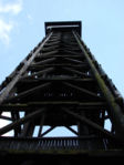 Goethe tower,one of the highest (43m) wooden towers in Germany Picture: Pudewills
 -
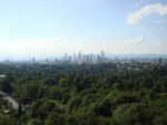 View from the tower to the skyline of Frankfurt. The wood in the foreground is part of the green belt Frankfurt. Picture: Pudewills


Airfield Bonames
-
 Part of the Bonames airfield plan Picture: Pudewills
 -
 The bridge connects the Frankfurt green belt over the river Nidda with the Regional park. Picture: Pudewills
 -
 The airfield is part of the flooding area of the river Nidda again. Picture: Pudewills
 -
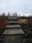 A lookout made out of used concrete slabs. The slabs were used for helicopter landing areas. Picture: Pudewills
 -
 Only a small path reminds on the past -a landing strip for military airplanes. Picture: Pudewills


Nature protection area Mönchbruch
-
 Hauntig lodge Mönchbruch Picture: Pudewills
 -
 Lookout tower into the nature protection area. Picture: Pudewills
 -
 View into the nature protection area. Picture: Pudewills


References
Please add literature, documentations and weblinks
Documentations:
- Joachim Blatter ,Universität Konstanz, Metropolitan Governance in Deutschland: Normative, utilitaristische, kommunikative und dramaturgische Formen der politischen Steuerung, Grundlage für einen Vortrag auf der Tagung „Stand und Perspektiven der politikwissenschaftlichen Verwaltungsforschung“ der Sektion Staatslehre und politische Verwaltung der DVPW vom 23.-25. September 2004 in Konstanz
- Brandt, J., B. Tress, and G. Tress: Multifunctional Landscapes: Interdisciplinary Approaches to Landscape Research and Management. – Conference material for the conference on “multifunctional landscapes”, Centre for Landscape Research, Roskilde, October 18-21, 2000. – Published in September 2000.
- UNESCO (2005) Operational Guidelines for the Implementation of the World Heritage Convention. UNESCO World Heritage Centre. Paris.
- Europäische Verflechtungen deutscher Metropolräume Forschungen, Heft 109, Hrsg.: BMVBS/BBR, Bonn 2002
- Gailing, Ludger 2005: Sustainable Landscape Development with Regional Parks. Overcoming Problems of Landscape Multifunctionality in Urban Agglomerations in: Paper for the ERSA Congress: “Land Use and Water Management in a Sustainable Network Society” 23-27 August 2005 Vrije Universiteit Amsterdam
- Planungsverband Frankfurt, 2005: Regionalpark RheinMain - "Der Landschaft einen Sinn - Den Sinnen eine Landschaft"
- Planungsverband Frankfurt, Regierungspräsidium Darmstadt 2005:Frankfurt/Rhein-Main 2020 –the European metropolitan region Strategic Vision for the Regional Land Use Plan and for the Regionalplan Südhessen Planungsverband Frankfurt/Rhein Main und Regierungspräsidium Darmstadt, 2005 Page 20
- Planungsverband Ballungsraum Frankfurt /Rhein-Main, 2007: Frankfurt/Rhine-Main Conurbation Planning Association, Tasks and Goals,
- Lehmann, Meike / Rautenstrauch, Lorenz: Regionalpark und Regionalmanagement: Synergien zwischen zwei neueren regionalplanerischen Handlungsansätzen?. In: DISP 150, Heft 3/2002, S. 46-53.
- Lehmann, M. (2000): Strategie Regionalpark– ein praktisches Handlungsfeld für das Regionalmanagement, in: DISP 143, S. 32 ff. Zürich. MAIER, J., et al.
- Rautenstrauch, L. 2006: Kulturlandschaft-Neue Steuerungsformen in Planung und Politik" - Tagung des Instituts für Umweltplanung der Universität Hannover (IUP) und des Leibinz-Instituts für Regionalentwicklung und Strukturplanung (IRS) am 17.03.2006 in Hannover
- Röhring, Andreas and Gailing, Ludger: Institutional problems and management aspects of shared cultural landscapes: Conflicts and possible solutions concerning a common good from a spatial social science perspective, Working paper, Erkner, Leibniz-Institute for Regional Development and Structural Planning, 2005
Links in English:
http://www.frm-united.com/Home.9.0.html?&L=1
Links in German:
http://www.regionalpark-rheinmain.de/
http://www.planungsverband.de/
http://www.rhein-mainische-forschung.de/atlas/
http://www.frm-united.com/Home.9.0.html
About categories: You can add more categories by copying the tag and filling in your additional categories