Planting Design 2013 Working Group 6 - Case Study C
---> back to group page working group 6
Natural environments, and how they return us to our roots
| Name | Tayrona National Natural Park | |||||||||||
| Location | Colombian Caribbean - Magdalena | |||||||||||
| Country | Colombia | |||||||||||
| Authors | María Fernanda González Duque | |||||||||||

| ||||||||||||
| {{#widget:GoogleMaps | width=300 | height=200 | lat=11.296934 | lng=-74.166496 | zoom=8 | centermarker=yes | maptypecontrol=yes | overviewmapcontrol=yes | largemapcontrol=yes | scalecontrol=yes
}} | ||
Rationale: Why is this case interesting?
- Why did you select it?
Natural Tayrona National Park ( declared so by the high biological and archaeological value) , is one of the most visited and important natural parks of Colombia, as it offers the spectator the opportunity to learn, live, perceive and explore the history of the country from its roots and gives them the opportunity to get to know more about the biodiversity that it has. Here ecoturism is not only well implemented, it also generates employment for the habitants of the region.
- Is it exemplary for a specific theme or a problem?
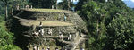
Although the park is a natural reserve, ecohabs have been integrated as part of the ecoturism program with great success with Tayrona's architectural characteristics, which perfectly blends and complements the landscape. Besides, the park has archeological vestiges from the Pre-Colombian era, the most important is Lost City (Spanish: Ciudad Perdida), and some other indigenous settlements all connected by a net of stone paths used over 500 years ago by the Tayrona indigenous, which lead to the beaches and other magnificent places.
- In what ways does the landscape relate to your life? Why do you feel attatched to this landscpe?
I live in the capital (Bogotá, which is located about 951 Km away from the park), and for me as an architect is really important to see historic and natural landscapes that are part of our heritage because it link us to our past. I believe protecting our heritage in every single way is crucial. The Tayrona civilization had an extensive knowledge about environmental care, as they had a very close relationship with the Natur; so I am interested in knowing more about it and also about the process of recovery, restoration and conservation of This kind of natural parks.
Author's perspective
From which professional background/perspective are your documenting this case?
Sustainable, ecological and green design has been present in my designs always, for me as an architect the landscape plays a very important role in the whole project conception, as this should be tied to the environment without causing any damage; it also provides us with all the important aspects (weather, flora, fauna, population, etc.) to start a successful design. I am documenting this case from a sustainable architectural point of view.
Landscape and/or urban context of your case
- Biogeography, cultural features, overall character, history and dynamics
- Illustration: Map; sketches; short descriptive analyses
The Tayrona National Natural Park (Spanish: Parque Nacional Natural Tayrona), is located in the Department of Magdalena, north of Colombia, in the Caribbean sea. With approximately 30 Km2 of maritime area and 150 Km2 of land area, is one of the most visited Natural parks of this country. Its extension goes from Taganga (western side) trough the coastline, until the Piedras River (eastern side).


- Biogeography:
Ecosystems: Due to the different altitudes presents around the park and the pyramid shape of the mountains, we can find temperatures between 25º and 32º, these conditions makes the park have a very dry or wet weather; here we can find tropical rainforest, dry forest, spiny forest, submontane forest, cloud forest and several ecosystems, such as Mangroves, Seagrasses, Coral reefs, Rocky coastline, Lagoons, etc.
Hydrography: Consists of two drainage systems, the maritime one is formed by a set of small streams and creeks that flow into the sea and the continental one is formed by the streams that flow into the Rio Piedras.
Flora and Fauna: The park has a natural wealth flora of over 350 maritime species and 770 terrestrial along with an extensive fauna, 15 species of amphibians, 202 species of sponges, 471 species of crustaceans, 96 species of annuals, 700 species of molluscs, 110 species of corals and 401 species of sea and river fish, 108 species of mammals, 300 species of birds, 70 species of bats, 31 species of reptiles. The coastal zone has the greatest wealth of marine vegetation of the whole Colombian Caribbean, with more than 31 types of different plants
- Cultural features:
History: The Tayrona, an ancient indigenous group of chiefdoms, dwelled this region (Sierra Nevada of Santa Marta) between the 800 a.C. and the 1600 a.C., before the arrival of the Spanish in Colombia, their economy was based on agriculture of fruital trees, corn crops and plants. They developed their civilization at 900 - 2000 meters above the sea, due to the mild climate and the variety of local products.
1498: First contact between indigenous and Spanish with Fernando González de Oviedo.
1525: Foundation of Santa Marta city.
1525-1599: Instability between Tayronas and Spanish which led to intense periods of conflict and war.
1600: Beginning of the decimation of the indigenous in hands of the Spanish.
-
 Ilustration: Sierra Nevada of Santa Marta -http://www.banrepcultural.org/blaavirtual/ninos/taironas/tairona10.htm-
 -
 Ilustration: The population -http://www.banrepcultural.org/blaavirtual/ninos/taironas/tairona10.htm-
 -
 Ilustration: The cities -http://cienciassociales6cacs.blogspot.de/2013/09/iv-periodo.html-
 -
 Ilustration: Period of conflict with the Spanish http://cienciassociales6cacs.blogspot.de/2013/09/iv-periodo.html-


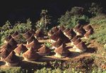
The survivors of this decimation were interned in the highest parts of the massif to escape from the Spanish; their descendants are the Kogi, who has maintained themselves isolated so far.
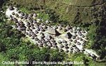
1973: A grave robber, found Lost City (Spanish: Ciudad Perdida).
1976: A Colombian scientific expedition arrived to the Lost City and begging with a process of restoration and conservation of the archaeological remains and the terraces of the city and the entire park.
1979: Is declared a Biosphere reserve of humanity by UNESCO
-
 Tayronas descendants, The Koguis
 -

-


The Eco-tourism there, is a great way to being interest and economic infrastructure to the reserve, without causing any damage to the ecosystem. It is amazing to be able to witness such a variety of ecosystems and also the archaeological remains of a Tayrona city of pre-colombian Colombia, the white sand beaches and waters in deep blue, gives great natural and historical diversity to the landscape.
Analytical drawings
Please add four analytical sketches/drawings (or montages/schemes) of your case and take the following aspects into account:
- natural dynamic versus cultural framework - in how far do these two forces come together in your case?
- dynamic through the year (you may imagine how the site looks in spring and summer, maybe you also remember it)
- highlight potentials and problems
- Analytical Drawings
-
 Elevation of the Park, main different heights
 -
analytical drawing 2
-
analytical drawing 3
-
analytical drawing 4

Projective drawings
- Please add four projective sketches/drawings (or montages/schemes) for your case and take the following aspects into account:
- How would you like this case to change in the near future? (in 1-2 years)
- And how could it look like in 10-15 years?
- Projective Drawings
-
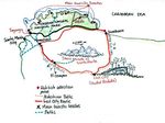 Location of the new stone paths to make more effective the rubbish collection
 -
 View of the new pedestrian paths (Based on Tayrona architecture)
 -
projective drawing 3
-
projective drawing 4


Summary and conclusion
Please summarize your case and give arguments for your projective design (approx 150 words).
Is a natural reserve part of the Colombian heritage located in the Department of Magdalena in the Caribbean coast. The region has indigenous vestiges from this community and there is a city call Lost City, where one can see the infrastructure, architecture and environmental management that this indigenous has. It's one of the most important natural parks in Colombia. Here one can find all the weathers, this is because the park rise from sea level to 5780 mts in the Sierra Nevada of Santa Marta (located in the Andes range), the highest altitude in Colombia. The pyramid shape of the mountains makes this region to have a large amount of ecosystems and a wealth in its biodiversity. This draws attention to thousands of tourists who visit the park every year.
The tourist has been causing a big contamination inside the park because of the rubbish that they generate, mainly in the shoreline. To forbid the access of some kind of food in the park will help to mitigate the negative impact that the rubbish has on it. Then, implementing rubbish recollection points along the main places in the shoreline of the park ensure the success of getting rid off of it. New pedestrian stone paths in the most critical areas which leads to the rubbish recollection points will help the park crew with the conservation of the biodiversity as some forest ecosystems are in danger because of this problem.
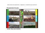
Image Gallery
You may add a series of images/photos in addition to the sketches/drawings
- Image Gallery
-
-
-
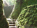 image 3 -http://traveljournals.net
 -

-
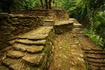 image 5 -
 -
-
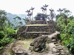 image 7


References
* Please make sure that you give proper references of all external resources used.
* Do not use images of which you do not hold the copyright.
* Please add internet links to other resources if necessary.
About categories: You can add more categories with this tag: "", add your categories