Planting Design 2013 Working Group 6 - Case Study B
---> back to group page working group 6
Rietveld Kallo: Highly dynamic nature reserve in the Port of Antwerp
| Name | Rietveld Kallo | |||||||||||
| Location | Beveren-Waas | |||||||||||
| Country | Belgium | |||||||||||
| Author | Jeroen Geudens | |||||||||||

| ||||||||||||
| {{#widget:GoogleMaps | width=300 | height=200 | lat=51.24645 | lng=4.280433 | zoom=14 | centermarker=yes | maptypecontrol=yes | overviewmapcontrol=yes | largemapcontrol=yes | scalecontrol=yes
}} | ||
Rationale: Why is this case interesting?
The nature reserve 'Rietveld Kallo' is part of the European Natura2000-network, that strives to protect endangered animal and plant species and their natural habitats. The focus of the Rietveld Kallo lies with small aquatic animals and sedentary and migratory birds. Its location right next to the Port of Antwerp makes for an interesting interaction between nature, industry, agriculture and residential space.
- The Rietveld Kallo is situated 2km from my home and forms a barrier between the Port of Antwerp (Europe's second biggest container port) and several agricultural villages. Due to the harbour expansion, a few smaller villages and vast expanses of rich agricultural land were turned into industrial space such as docks, loading bays and logistics. To prevent unrestrained expansion, a masterplan set out boundaries to safeguard the agricultural land and to guarantee the liveability of the smaller towns within these lands next to the harbour.
- The Rietveld Kallo is one of a few nature reserves that helped create this barrier. Because of the harbour expansion, several former smaller nature reserves disappeared, but are now compensated within larger, interconnected nature reserves. The Rietveld Kallo is only a few years old, as it was conceived to replace a former nature reserve that disappeared due to the construction of a freight line.
Author's perspective
After my bachelor's degree in landscape architecture I followed a 1-year programme in landscape development. This programme followed a strong analytic approach of landscapes on large to very large scale levels. A few important themes were history, ecology, GIS, planning and policy. All aspects of a landscape were examined, assessed, valued and turned into design or planning principles. Because of the unique layout (albeit not in a positive way) of the mostly small-scale landscape types in Flanders, one of the main themes landscape architects and planners have to deal with here is connecting the few remaining open landscapes through natural corridors, densificating urban areas as to not take up anymore open space and increasing the amount of 'Green' (as in nature reserves and forests), since Flanders is one of the worst regions in Europe in this field. The Rietveld Kallo is a fine example of planning on different scales and political levels: From a European policy on interconnected natural habitats to a greater local biodiversity, it shows us that every bit of nature can play its' role in a larger whole, and that nature cannot be seen as isolated and bordered entities.
Landscape and/or urban context of your case
- Image Gallery
-
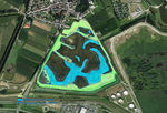
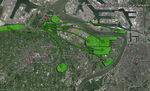
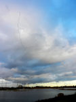
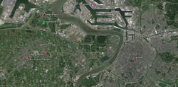 Overview of the surrounding area and context
 -
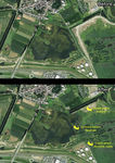
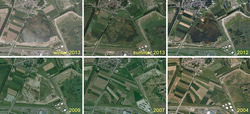 From farmland to reed marshes


- The Rietveld Kallo consists of different types of vegetation structures:
1. The largest part is marshland. There are a few areas that are always submerged throughout the year, and others that are flooded periodically during late autumn and winter. Because of this there's a high dynamic in vegetation, with certain types such as reeds and grasses that are found in large quantities on the borders of these wetlands and that are persistent over the years. Next to that there's a lot of annuals that pop up randomly because of the flooding dynamic and the transportation of seed through the water.
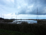
2. Another feature are the earthen dikes. These are currently mown once or twice a year, and are inhabited by several native perennials, annuals and a few seedlings from trees and shrubs. Throughout time, these lands will be turned into woodland and serve as natural barrier against air and noise pollution from the nearby highways, railways and port activities.
3. A few borders of the reserve are formed by tree-lined avenues. These trees are important landmarks and also serve as nesting place for several birds who do not nest near the waterside.
- This nature reserve is part of a very large area that was reclaimed from the sea by the use of dikes and water drainage systems, and afterwards turned into farmland. This reserve used to be farmland as well, but to reinstate it as wetland, a lot of digging had to be done to restore the original contours. Historically, this area's height was only about 1 to 1.5m above sea level. Nowadays, the whole region lies at a height of 5 to 8 meters. The earth that was recovered from digging was used to build the earthen dikes that now border the reserve.
Analytical drawings
- Analytical Drawings
-
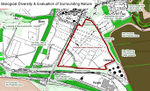 Biological Diversity & Evaluation of Surrounding Nature
 -
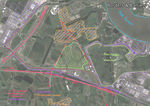 Borders & Barriers
 -
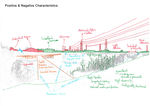 Positive & Negative Characteristics
 -
 Natural Dynamics


Projective drawings
- Please add four projective sketches/drawings (or montages/schemes) for your case and take the following aspects into account:
- How would you like this case to change in the near future? (in 1-2 years)
- And how could it look like in 10-15 years?
- Projective Drawings
-
 Connect adjacent nature reserve
 -
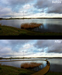 Improve accessibility
 -
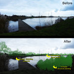 Increase screen and structural planting
 -
 Create a large interconnected ecological network


Summary and conclusion
Please summarize your case and give arguments for your projective design (approx 150 words).
Image Gallery
- Image Gallery
-
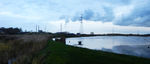
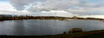 Panoramic view in late autumn
 -
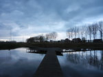 Wooden decks & pathways blend in naturally
 -
 The nature reserve is popular with all sorts of birds
 -
 Reeds give protection and create nesting areas for all types of animals
 -
 Earthen dikes enclose the reserve and form a barrier between nature and the harbour


References
* Please make sure that you give proper references of all external resources used.
* Do not use images of which you do not hold the copyright.
* Please add internet links to other resources if necessary.
About categories: You can add more categories with this tag: "", add your categories