Planting Design 2013 Working Group 4 - Case Study B
Jump to navigation
Jump to search
---> back to group page working group 4
The cornerstone of the greenbelt of Valencia, Spain.
| Name | Parc de Capçalera | |||||||||||
| Location | Valencia | |||||||||||
| Country | Spain | |||||||||||
| Authors | Anna Martínez | |||||||||||

| ||||||||||||
| {{#widget:GoogleMaps | width=300 | height=200 | lat=39.474825 | lng=-0.408383 | zoom=12 | centermarker=yes | maptypecontrol=yes | overviewmapcontrol=yes | largemapcontrol=yes | scalecontrol=yes
}} | ||
Rationale: Why is this case interesting?
- The principal reason I chose the "Parc de Capçalera" is because it's the cornerstone of the old Turia riverbed. In 1957, took place the vast flood of Valencia, then the local administration decided to change the natural course of the river and they built the biggest urban garden/park in Spain there.
- Specificly nowadays the "Capçalera" park links the old riverbed, totaly an urban and ornamental garden, with the natural ecosystems that remain outside the city.
- Personally, I grew up in Valencia and I have seen the initial situation from the beginning, obviously after the vast flood. And although the result it's nice, I'd like to see other posibilities.
Author's perspective
As a graduate in environmental science degree, my perspective is based on the interaction in urban areas with the environment. And also the idea of create a green area must accomplish a social and ecological function.
Landscape and/or urban context of your case
- The Parque de Cabecera is the lengthening of the old greenbelt great Turia. Thus achieving portion of the project which unifies the natural bed Túria with artificial (new riverbed) by restoring the original character and vertebrador of the river. The park gives to the city and the metropolitan area a green space because of its size and setting works as a frame for the realization of numerous activities.
- Valencia was formed on an alluvial plain surrounded by a double meander of a torrential river, the Túria. The river ran forming a set of belts that bind and separated leaving small alluvial islands between them.
- This urban park landscape represents the original River Turia, in this case water is the main element that determines the topography, vegetración and equipment.

Analytical drawings
- In my case the connection between the cultural framework and the natural dynamic is very patent, because the history background of the place defines the location of the park inside the city and the planting design has the water as principal element.
- The dynamic in the Mediterranean region are not very marked in colours but in fragance, the same species of Mediterranean forests protect against cold and heat almost to the same extent. What creates differences between them and other stations are the exotic plants that provide colorful in the spring, the animals, and the riverside forest. And also the abundance of people changes.
- Analytical Drawings
-
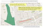 analytical drawing 1
 -
 analytical drawing 2


Projective drawings
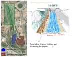
- I would like to represent a more natural ecosystem, even the place is situated near the city, I think that it brings the opportunity of transform the environment. Also I'd like to afford to the people an open space, integrated between the old city and the suburbs. I will start to remove the retaining wall of the stream, and I will put a wood structure with some Salix atrocinerea, that will make easy to appear the first shoots. In addition i will remove parts of the concrete that is used today for delimitate the end of the park, it will be more conciliatory another elements like sand, rocks or gravel.
- In 10 years it will seem more like an old river, the old Turia river, and the Salix will be replaced for native plants. The Salix is used to create optimal conditions. Besides the filter on the big pond will change the colour of the water, the animals and then the landscape. The result of change the planting density of the hill will become in make the top higher than today, and it will motivate the people to access there.
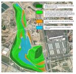
- Projective Drawings
-
 bioengineering phase http://www.naturalea.eu/es/tecniquesbioenginyer:Cos2
 -
 River area for natural recovery


Summary and conclusion
- This park has many potentials to make it a reference site, because the history, the location and the clima. Valencia has average temperatures about 17 ºC, so the visitors like to enjoy the outside almost during all the seasons. For me the particularity that makes the park an interesting case, is that is a connection between the urban landscape and the rural environment. Nowadays, the feeling is that the park is in the middle of the city, so the people goes there but they don't enjoy it. If we are walking from the city, around the existing urban garden and we bring closer to the park, the tour will be like this: use the top of the hill like a focus point to reach the visitor. Then, from there discover the new landscape, more natural and similar to the river ecosystems.
Image Gallery
You may add a series of images/photos in addition to the sketches/drawings
- Image Gallery
-
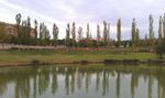
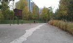 Point where starts the park 1
 -
 Point where starts the park 2
 -
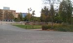
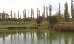
 It gets the people inside the park
 -
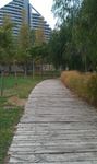
 Fork in the path
 -
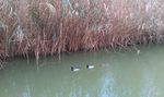 Anas platyrhynchos
 -
 Lookout on the lake 1
 -
 Lookout on the lake 2
 -
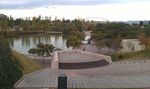 Amphitheater
 -
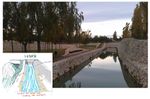
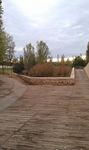
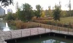 Gangplank


References
* Please make sure that you give proper references of all external resources used.
* Do not use images of which you do not hold the copyright.
* Please add internet links to other resources if necessary.
About categories: You can add more categories with this tag: "", add your categories