Planting Design 2013 Working Group 3 - Case Study C
---> back to group page working group 3
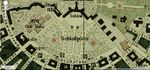
Schloß Platz, Karlsruhe
| Name | Schlossplatz | |
| Location | Karlsruhe | |
| Country | Germany | |
| Authors | Nishtha Bali | |

| ||
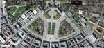
| <googlemap version="0.9" lat="49.01135" lon="8.40381" type="satellite" zoom="15" width="300" height="250" selector="no" controls="small">
</googlemap> | ||
Rationale: Why is this case interesting?
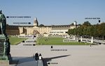
Karlsruhe is a fan shaped city, with the Schloss(Castle) at its base, the Schloss Platz is the foreground to this Baroque Castle which was originally built in 1715, destroyed during World War II and rebuilt as a museum with a restored facade mimicking the original.
The function of the building changed and so did that of the Platz. What was originally more of a private space changed to a public space when the building was restored as a museum. What did remain same was the key theme, that of a strictly planned space, so as to provide a formal foreground to the castle.
The city is undergoing major changes owing to the construction of the U Bahn, with large gaping holes of construction sites everywhere. The Schloss Platz is almost like a haven now, peaceful and quite in comparison to the drilling noises in the city.
Author's perspective
I am an architect, who has a special interest in historical sites, their restoration and reuse. Change is inevitable for most historic sites, because of the fact that the structure of society has changed manifold since they were created. The Schloss Platz is an exemplary case in this regard, as even though the primary function for it changed greatly over the years, the basic structure and geometry that it follows remains almost the same.
Landscape and/or urban context of your case
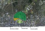
The Schloss is the focal point of the city with streets radiating from it towards the south. To the north of the Schloss is a vast green area(the Schloss Garten), with multiple sports facilities dispersed within it. The Schloss Platz is almost like a barrier between the wild, unencumbered greens of the Schloss Garten in the north and the strictly planned fan shaped city in the south.
Historically, the Platz served many different functions. It was a botanical garden till 1738, later as a parade ground and is now a large public space, pedestrian connection to various areas around it and is often used as an exhibition space.
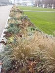
The left and right wings of the Schloss Platz are small groves of trees with a strict boundary of lime trees. Inside these boundaries is where the actual treasures of the garden lie, a rare collection of trees from around the world. These wings are almost like a connection to the Schloss Garten in the north, owing to the fact that they are not as planned as compared to the rest of the platz.
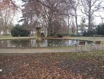
The latest remodelling took place in 2010/2011 in preparation for the city's 300th birthday. The lawns were raised by 20 centimeters and divisions of small pools of water(about 5 centimeters in depth) where made.
- Maps
-
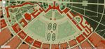 1876
1876 -
 1948
1948 -
 1965
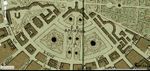
1965 -
 2008
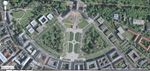
2008 -
 2013
2013


Analytical drawings
Please add four analytical sketches/drawings (or montages/schemes) of your case and take the following aspects into account:
- natural dynamic versus cultural framework - in how far do these two forces come together in your case?
- dynamic through the year (you may imagine how the site looks in spring and summer, maybe you also remember it)
- highlight potentials and problems
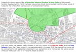
Presently, the Schloss Platz is a boundary of sorts between the natural green area to the north(which culminates into the Schloss Garten) and the city to the south. The urban area of the city is disconnected with the Schloss Garten and the Green area to its north.
- Analytical Drawings
-
 Analysis 1
 -
 Analysis 2
 -
 Urban Context
 -
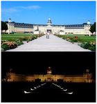 Day and Night
 -
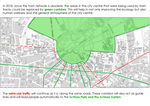
 Urban Analysis


Projective drawings
- Please add four projective sketches/drawings (or montages/schemes) for your case and take the following aspects into account:
- How would you like this case to change in the near future? (in 1-2 years)
- And how could it look like in 10-15 years?
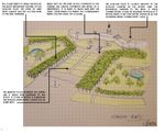
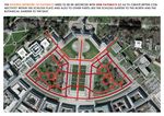
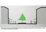
What: Improving the physical connectivity in the Schloss Platz(both within the Platz and to the Garten to the north).
When: In 1-2 years.
Where: Schloss Platz
Why: To improve accessibility to and from the Platz.
How: Changing the pathways, more welcoming entries.
What: Creating green corridors and connecting them to the Schloss Platz and Schloss Garten.
When: In 10-15 years(when the U Bahn Project is complete.
Where: The city centre.
Why: To improve the Urban green connectivity.
How: Introducing green spaces in the areas/tracks of the old tram network which will be obsolete once the U Bahn comes into picture.
- Projective Drawings
-
 projective drawing 1
 -
 projective drawing 2
 -
 projective drawing 3
 -
projective drawing 4


Summary and conclusion
To summarise I would say that the Schloss Platz can greatly change its funtion from that of a boundary between the green space and the city to being a node that brings the two together. Connectivity is key here; green and pathways. Within the platz it is important to create more accessible routes for the side gardens from the central Platz area. The U bahn project opens up great opportunities for the city to develop its green areas by using the old tram track spaces as new green spaces. This need not be as natural as the other train tracks projects in Germany but can be developed as semi-formal green spaces, keeping the urban pattern of the city in mind.
Image Gallery
You may add a series of images/photos in addition to the sketches/drawings
- Image Gallery
-
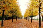 Lime trees in Autumn
 -
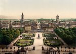 View from the Schloss ca 1940's
 -
-
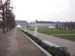
 Side Garden
 -
 Winter


References
* Please make sure that you give proper references of all external resources used.
* Do not use images of which you do not hold the copyright.
* Please add internet links to other resources if necessary.
http://geodaten.karlsruhe.de/stadtplan/
About categories: You can add more categories with this tag: "", add your categories