Planting Design 2013 Working Group 3 - Case Study A
---> back to group page working group 3
Please add the title of your case study here, adjust the map coordinates and replace the moa image with a characteristic image of your site
| Name | Bicentennial Park | |||||||||||
| Location | Av. bicentenario 3800, vitacura, Santiago | |||||||||||
| Country | Chile | |||||||||||
| Authors | Leslie Iturra M. | |||||||||||

| ||||||||||||
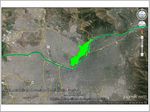
| {{#widget:GoogleMaps | width=300 | height=200 | lat= -33.398915 | lng= -70.601971 | zoom=13 | centermarker=yes | maptypecontrol=yes | overviewmapcontrol=yes | largemapcontrol=yes | scalecontrol=yes
}} | ||
Rationale: Why is this case interesting?
Please give a short introduction to the site you have selected (not more than 150 words)
- The "Parque Bicentenario" (Bicentennial Park) is situated in the shore of the only river that cross Santiago, and in the last years has turned from an empty piece of land (which is part of a Metropolitan Park zoning in Santiago) to a beautiful and peaceful park.
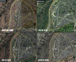
- Before being intervened this zone was a vulnerable point in the city between a highway and a residential area (Despite being one of the more wealthy residential area in the city) this condition makes that the rest of the land around it was affected for this nonuse area (see image Land 2000). Nowadays we can see the results here, and see this park as an example of how residual areas of a city can be joined to the city and also give value to a zone.
- This park has become in a good quality green area in Santiago with 24.000 visitors per year. It under level street design allows privacy and works as a refuge and also facing the Metropolitan park, which is a hill inside the city, gives to this park a sensation of continuity.
Author's perspective
From which professional background/perspective are your documenting this case?
I am architect, who is interested in understanding of the city´s transformations through catalysts; in this case in particular, I am interested to show how a part in the city can be affected when in the land a green space is built, in this park before was a empty space that was rounded by some empty spaces too. rounded this land is a residential area that saw his rates of value raised by this intervention. Now this area of the city is well evaluated, this neighborhood has more density and is an area that won plusvalue. other hand, the design is significant, because trying to extend the landscape to the hill, joining it to the topography of the place and in turn to hide the highway, giving to this area of the city an atmosphere of shelter, but in my opinion trying to hide the highway the architect hided the river too, what is a mistake design, because I feel that using the river as part of the park, this area would be more interesting, and a such a potent element in the topography of a city gives many possibilities in the experience of the design.
Landscape and/or urban context of your case
- Biogeography, cultural features, overall character, history and dynamics
Project owner:Municipality of Vitacura.
Designer: Architect Teodoro Fernández (public contest).
Inauguration: 1st stage: December 2007 / 2nd Stage: November 2011
Total area: 314.314 m2 green area,
Path: 6 kilometers of pedestrian paths; 3,2 kilometers of bike ways
Vegetation: 4.000 trees which are native species 1.300.
Native Trees:(Chilean Names)
Bellotos: Protected specie, endangered, heights of 15 meters.(http://en.wikipedia.org/wiki/Beilschmiedia_berteroana)
Pataguas: heights of 10 meters, white flowers. (http://en.wikipedia.org/wiki/Crinodendron_patagua)
Peumos: heights of 25 meters, red edible fruit. (http://en.wikipedia.org/wiki/Cryptocarya_alba)
Quillay: heights of 20 meters, green/White flowers. (http://en.wikipedia.org/wiki/Quillaja_saponaria)
Arrayán: endangered, heights of 4 meters, cream color flowers, yellow fruit.(http://en.wikipedia.org/wiki/Myrceugenia)
Chilean Palm: partially protected, heights of 25 meters, edible nuts.(http://en.wikipedia.org/wiki/Jubaea_chilensis)
Espinos: heights of 5-6 meters, yellow flowers (http://en.wikipedia.org/wiki/Acacia_caven)
Non native species:
Holm oak (Encina): Mediterranean region, heights of 16-25 meters, (http://en.wikipedia.org/wiki/Quercus_ilex)
Oriental plane (plátano oriental): eastward from the Balkans, heights of 30 meters or more. (http://en.wikipedia.org/wiki/Platanus_orientalis)
Cockspur Coral Tree (Ceibo): Argentina , Uruguay, Southern Brazil and Paraguay, heights of 5- 8 meters, red flowers (http://en.wikipedia.org/wiki/Erythrina_crista-galli)
Jacaranda: central America, south America, cuba Hispanoila and The Bahamas, heights of 20-30 meters, purple-blue flowers.(http://en.wikipedia.org/wiki/Jacarand%C3%A1)
Lagerstroemia indica (crespón): China, Korea, Japan and Indian Subcontinent, heights of 6 meters, white, pink mauve, purple or carmine flowers. (http://en.wikipedia.org/wiki/Lagerstroemia_indica)
Sweetgum (liquidambar): heights of 25-40 meters (http://en.wikipedia.org/wiki/Liquidambar).
Cork Oak (alcornoque): Europe and northwest of Africa, heights of 20 meters (http://en.wikipedia.org/wiki/Quercus_suber)
Bald Cypress (ciprés calvo): USA, heights of 25- 40 meters (http://en.wikipedia.org/wiki/Taxodium_distichum)
Mexican fan palm (palma washintoniana): Western sonora and Baja california in Mexico. heights of 25 meters, white flowers (http://en.wikipedia.org/wiki/Washingtonia_robusta)
Parkinsonia: semi-desert of africa and America, heights of 5 -12 meters, yellow and white flowers, (http://en.wikipedia.org/wiki/Parkinsonia)
Lagoons: 2 artificial lagoons.
Wildlife: in the north lagoon lives different kind of birds such as Chilean Flamingo (http://en.wikipedia.org/wiki/Phoenicopterus_chilensis), Black-necked swan (http://en.wikipedia.org/wiki/Cygnus_melancoryphus), Koi Fish (http://en.wikipedia.org/wiki/Koi) and the followings has emigrated to the park: Great Egret (Garza blanca) (http://en.wikipedia.org/wiki/Ardea_alba), White winged Coot (Tagua) (http://en.wikipedia.org/wiki/Fulica_leucoptera)
Features of design:
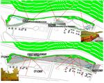
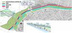
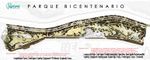
The design aims to be a pole of physical and administrative activity, in the park are the public activities in general and the administrative one(including onto the design of the park) is in the municipality building. Moreover this park seeks to preserve some native species of Chile, including it as part of the design. the park has three different areas: (See image park areas)
a) Ramps of access, which joins the street and the park (because of the searching of privacy and visual continuity is under level of the street) under the uneven ground is the equipment program, so the land turn itself as an architecture program.
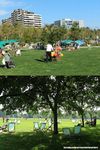
b) Central esplanade, which is the place where the most of activities occur. In this area is the pedestrian way to go along the park and the place to rest in the grass or play in the playground, as well as for children and pets. Also it is 2 lagoons the north one is reserved for the wild life by hosting different types of birds and fishes and the south one is reserved to play with boats (toys). The mass-activities has its place also in a little amphitheater and a esplanade beside the municipality building. The spiritual life is placed in a little oratory situated between the esplanade and the building.
c) The slope: which is a visual and acoustic screen that protect the park of the highway (and separates the park of the river) and create a lookout along the park.
- Maps
-
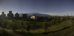
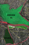 AERIAL VIEW OF THE AREA
 -
 LAND IN 2000
 -
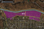
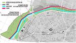
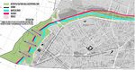
 NORMATIVE CONTEXT
 -
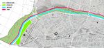
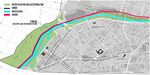
 PARK AREAS


Analytical drawings
Please add four analytical sketches/drawings (or montages/schemes) of your case and take the following aspects into account:
- natural dynamic versus cultural framework - in how far do these two forces come together in your case?
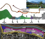
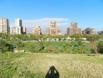
CONDITIONS OF VIEW: In a place of the country that is getting less natural - in its original meaning- this park framed the nature of the zone. In this sense this park acts as a lookout, in one direction as a window unto the city and in the opposite direction as a lookout of the central valley, doing a wink to the original landscape of the zone, this is one of the few zone in the plane on the city that shows the immensity of the mountain cordons that rounds Santiago. In this sense the two areas in the opposite side of the park (street and slope) has its design to reinforce this use, because is a place to walk along the park (pedestrian ways) and also is a place to stop and look or rest below the trees, in this case the trees act as point of roof.
WATER SCARCITY: In a zone of the country that is particularly dry, this project does an effort to reuse the water that is used in the lagoons to watering the park (as a water reservoir), which in turn, is also used as a stabilizer climate in the summer when is really hot, the evaporation does the area fresher. About water scarcity and species, the project uses plant that resist well to lack of water, or long period of dry summer, which is the case of Santiago (Mediterranean-long summer season weather), this design aims to decrease the demanding of maintenance (15.200 US/water monthly in summer - 950 USD in winter). The native species are accustomed to this weather and has a good performance as well as the non native species that were used; not the grass, that is used as part of the requirement of the use in the rest area (central area). undoubtedly, the grass area is a reflect of a foreign image, such as Hyde Park in London.
DENSITY: Before that this urban proposal takes form, this area was not important, in fact was one of the worst part in this area, but now after this intervention the land increased their price and the real state business has taken part in it. Which was an area of 2 story houses, now it has become in a high building apartment area,taking into account that the normative has not changed before and after, but changed the interest in this area. Regardless of the opinion that each has about the real estate business, this has made increased considerable density of sector.
- Analytical Drawings
-
 CONDITIONS OF VIEW
 -
 WATER RESERVOIRS
 -
 SANTIAGO V/S LONDON STYLE
 -
 RISE OF DENSITY


- dynamic through the year (you may imagine how the site looks in spring and summer, maybe you also remember it)
IMAGE: This park was designed to seems always green, it's large grass extensions are the whole year green, regardless the trees color, the general perception of this park is always the same (predominantly green with some brown). Anyway, species are not reached a considerable height to be as important in the image.
- Analytical Drawings
-
 VIEW ALONG THE TIME
 -
 GREEN VIEW IN SUMMER
 -
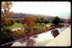 VIEW IN AUTUMN
 -
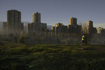 VIEW IN AUTUMN MORNING
 -
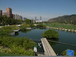
 PANORAMIC VIEW- CITY AND GREEN


- highlight potentials and problems
Highlight potentials:
1.- Use of the surrounding landscape as a part of the landscape design.
2.- Mark the routes and observation points with foliage.
3.- modifying the topography the project (slope and depression) achieves to extend the sensation of park, joining visually both of parks (Bicentennial and Metropolitan park.
4.- try to do a rational use of the water, using the lagoons as reservoirs.
5.- Use of native species that gives a regional image to the park, including also a water saving. The non native species in the park, has good performance to lacking of water.
Problems:
1.- Ignore the river that runs beside the park, but is not totally a problem of the designer, because there is a way between the river and the park, that makes difficult to extend of the park toward the river, instead it would be better if this street would have been removed as the other one that was removed from the middle of the park. In this way, the park would make use of this natural resource, both irrigated and design.
2.- The slope, although helps with the highway topic, this segregate the river and all design opportunities that could finds place in the shore.
3.- the water cycle is not complete, because to fill the lagoons is used potable water, instead use sewage cleaned.
4.- The park is disconnected of the metropolitan park system, as well as the hill and the shore river, but I must say that is being studied a bridge that seeks connect the hill with the park, but nothing about the river park area.
Projective drawings
- Please add four projective sketches/drawings (or montages/schemes) for your case and take the following aspects into account:
- How would you like this case to change in the near future? (in 1-2 years)
1.- RIVER: involving the river into the park design in order to use more the hydric source and explode its aesthetic potential. In this sense the river would be used like lagoons too, avoiding to use drinking water to fill the lagoons, and then that the water was used as ornamental element can be used for watering plants.
2.- SHORE: Including the shore of the river along its path, in order to connect the park with the rest of the park system along the river, in this way the design will join the river, Bicentennial Park and the rest of the city en a park system.
3.- BRIDGES: Green bridges to connect the Bicentennial park with the hill, in this way the visual connection achieve to become in real connection, allowing to visitors traverse the river and walking from one side of the city to the other.
- And how could it look like in 10-15 years?
4 and 5.- The image of the park would be like a park that belongs to a whole community, I means a park that is insert in a metropolitan system and not only as a neighborhood park, I imagine a park that will be a route from one the west city (a poor part of the city) to the east part (the wealthiest part of the city) and the Bicentennial park will be part of this park, and the visitor will can enjoy of the river and the green field, while is walking over the city.
- Projective Drawings
-
 1.- SUSTAINABILITY &INCLUSION
 -
 2.- CORRIDOR ALONG THE RIVER
 -
 3.- CHANGING THE SCALE
 -
 4.- IMAGE
 -
 5.- FINAL IMAGE IN THE CITY-PARK SYSTEM


Summary and conclusion
Please summarize your case and give arguments for your projective design (approx 150 words).
This park belongs to a system of metropolitan park areas in Santiago, which has been built as a neighborhood park, which is successful and has become this area from a depressed area in a wealthy area into a high density and very appreciated area in the city, but the project forgot to connect with the rest of the city and the river beside, in fact, this park deliberately hides the river , because is next to a highway, through creating a slope in the park that also seek the visual connection with the hill, which belongs also to the metropolitan park area. My proposal is seeking to join the park with the river and the hill, in order to integrate this park with the rest of the city, and gives to the river more participation, as well as a corridor as a ornamental and sustainable element.
Image Gallery
You may add a series of images/photos in addition to the sketches/drawings
- Image Gallery
-
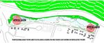
 Park Scheme
 -
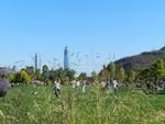 image 1
 -
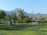 image 2
 -
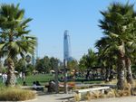 image 3
 -
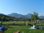 image 4
 -
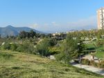 image 5
 -
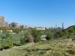 image 6
 -
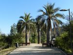 image 7
 -
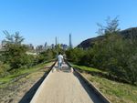 image 8


References
* Please make sure that you give proper references of all external resources used.
information: http://www.plataformaarquitectura.cl/; http://www.vitacura.cl/
some images: http://www.flickr.com/
Maps: Google earth application
* Do not use images of which you do not hold the copyright.
* Please add internet links to other resources if necessary.
About categories: You can add more categories with this tag: "", add your categories