Planting Design 2013 Working Group 18 - Case Study C
---> back to group page working group 18
Santiago de Compostela, spontaneus vegetation in the historic city. Monte Gaias to Brañas do Sar
| Name | Gaiás Hill from Sar pastures | |||||||||||
| Location | Santiago de Compostela. Galicia. | |||||||||||
| Country | Spain | |||||||||||
| Authors | Aurora | |||||||||||

| ||||||||||||
| {{#widget:GoogleMaps | width=300 | height=200 | lat=42.880485 | lng=-8.54567 | zoom=8 | centermarker=yes | maptypecontrol=yes | overviewmapcontrol=yes | largemapcontrol=yes | scalecontrol=yes
}} | ||
- Why did you select it?
Santiago de Compostela is European medium size city, known for being the final destination of the Saint Jacques pilgrimage route. Its historic center was declared Unesco World Heritage in 1985. The conservation of the medieval urban structure of the city has allowed "nature" and the rural scape to be present in the life of the center of the city. Traditional land management technics still informs the vegetation of many of the green spaces of the city. The variety of plant communities that citizens and visitors can enjoy is an integral part of it´s image, the quality of the daily life and its landscape. Two rivers surround Santiago and many hills inform its landscape. Studying the vegetation of a section from hill to river is an opportunity to understand many other areas in the city. Monte Gaiás is one of these hills visible from many areas of the city and one that keep the traditional land management technics till recently. New physical interventions seem to threaten the establish cycles (water, nutrients,...) and therefore the "traditional" plant communities.
- Is it exemplary for a specific theme or a problem?
Careful understanding of indigenous plant communities, indigenous species appearing in a spontaneous way, traditional crops and "traditional" garden species inside cities is important to develop a palette of species and to learn how to use them, in order to develop planting designs that "belong" to the place, are recognizable by the citizens and are sustainable due to its lower maintenance requirements and because they are already part of the wider ecosystem helping it to keep a certain balance. The challenge is in many occasions how to maintain or manage that equilibrium that was base on hard work of many independent farmworkers and their animals in a contemporary society.
- In how far does it relate to your life?
Daily we are in contact with diverse green spaces in the city. We see them from our windowsills and office and enjoy then in the way to school or to the shops. Santiago has a decent amount of green areas both to privately grow crops, enjoy gardening as well as public parks. I've been always fascinated by the soft integration of the vegetation (the image of the "natural") with the strict granite built fabric.
Author's perspective
From which professional background/perspective are your documenting this case? As architect and landscape architect I do projects and studies in Santiago de Compostela and other medium side cities with historic and cultural value, where the consideration to the existing vegetation and the understanding of ecosystems is very relevant for their landscape and for the sustainability of our proposals.
Landscape and/or urban context of your case
- Biogeography
Santiago sits on granitic rock and therefore the soil apart from the river basins in thin and acid. As mention before topographically is a hilly area. This portion of valley or hillside that goes from the top of the Gaiás hill to the pastures next to river Sar followed until recently the traditional land management, the land was divided in two specialized types of productive spaces, the hillsides and the fields. From top to bottom generally will appear the forest and scrublands, the hamlets and the intensively work orchards (not present in this section), paths and bellow those fields where to grow crops and finally the flooding areas that were use as pasture and wet forest. Along this line carefull water management was implemented in order to irrigate and deliver nutrients from the upper areas to the rest of productive spaces.
In this case the top of the hills was a cultivated shrub land with heathers, broom and specially gorse. Gorse (Ulex europaeus) was useful to make beds for the cows that mix with animal detritus was them use as fertilizer. Apart from that the gorse and broom (Cytisus scoparius, Cytisus multiflorus) help to fix nitrates so they were use to improve the soil and also feed with nutrients the running of water from this top water catchment areas. The hill side fields are still use to grow crops as corn and one can still read the pattern of the pastures and wet forest.
Cultural features, overall character, history, and dynamics In the last decade a big cultural infrastructure, named as City of Culture, was built at the top of the hill shaving its top to make place for the new "mountain shape buildings". Big chunk of the hill is own by this institution but the landscape project is not being develop yet.
Roads running parallel to the contour lines were built breaking the water/nutrients flow. All of the running off rain water that falls both in the city and the Gaías go into the public sewage system.
The urban city plan has preserved the lower areas (hill side fields and pastures) but there is not a clear strategy for them. The plan aims for a big scale park with public facilities, some of then already built.
This area was completely managed and modify by humans through history, following "organic" cycles. It's now a cultural landscape in risk of disappear integral to the historic city fabric.
As mention before with the new cultural infrastructures and other public facilities this area pretends to be more insensibly use by the citizens and visitors.
Analytical drawings
Please add four analytical sketches/drawings (or montages/schemes) of your case and take the following aspects into account:
- natural dynamic versus cultural framework - in how far do these two forces come together in your case?
- dynamic through the year (you may imagine how the site looks in spring and summer, maybe you also remember it)
- highlight potentials and problems
- Analytical Drawings
-
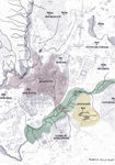 Gaias, Rio Sar and Compostela
 -
 Gaias, Rio Sar together with surrounding important city infrastructures as well as building works infrastructure.
 -
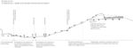
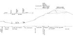 Section
 -
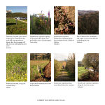 Pictures showing different plant communities from the Gaias hill top to the Sar River


Projective drawings
- Please add four projective sketches/drawings (or montages/schemes) for your case and take the following aspects into account:
- How would you like this case to change in the near future? (in 1-2 years)
- And how could it look like in 10-15 years?
- Projective Drawings
-
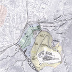
 New water managment brings rain water&nutrients back to valley land.
 -
 New managment and new walkways allow for more public access and recreational and horticultural uses.
 -
 The introduction of planting (based on local species)helps the habitats to develop in a more complex and sustainable way.

Summary and conclusion
Please summarize your case and give arguments for your projective design (approx 150 words).
Image Gallery
You may add a series of images/photos in addition to the sketches/drawings
- Image Gallery
-
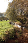 Sar river flood plain
 -
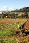 Gaias hill side fields. November.
 -
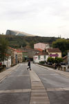 Gaias presence from the Historic City.


References
- To know more about the CIDADE DA CULTURA: https://www.cidadedacultura.org/
- To know more about Santiago de Compostela´s GREEN STRATEGY: http://intervencionurbanasostenible.wordpress.com/2012/01/03/estrategia-verde-urbana-de-santiago-de-compostela/
-To know more about the history and archeological importance of Brañas do Sar:
http://digital.csic.es/handle/10261/27652
-To know more about the flora in Galicia: http://www.flickr.com/photos/teresalaloba/sets/72157626288877685/#
* Please make sure that you give proper references of all external resources used.
* Do not use images of which you do not hold the copyright.
* Please add internet links to other resources if necessary.
About categories: You can add more categories with this tag: "", add your categories