Planting Design 2013 Working Group 17 - Case Study A
---> back to group page working group 17
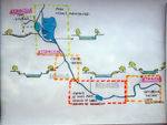
Restrained Changhe River
| Name | Restrained Changhe River | |||||||||||
| Location | Beijing | |||||||||||
| Country | China | |||||||||||
| Authors | Ma Junge | |||||||||||

| ||||||||||||
| {{#widget:GoogleMaps | width=300 | height=200 | lat=39.966667 | lng=116.266667 | zoom=8 | centermarker=yes | maptypecontrol=yes | overviewmapcontrol=yes | largemapcontrol=yes | scalecontrol=yes
}} | ||
Rationale: Why is this case interesting?
Linking Yuquanshan Hill and Zhongnanhai Lake, which are both royal property in Qing Dynasty, Changhe River is a river full of stories. It was clear decades ago and people nearby usually swim and fish here. However, as the city expanded quickly, when it finally became part of urban space, the government made a terrible decision- to concrete the riverbed. Actually, most rivers in unbar districts experienced the same thing during the last 20 years of the 20th century. The government believed that concrete riverbed could protect the city and people from floods by letting them flow away in a short time. The link between it and the nature was cut off and it lost vitality. I selected it as my case because I want the lively river to be back and I have faith in it. Actually, in east China, most rivers in unbar districts experienced the same thing as Changhe during the last 20 years of the 20th century. The government believed that concrete riverbed could protect the city and people from floods by letting them flow away in a short time. But they were wrong. On the one hand, the concrete riverbed prevents flood water from infiltrating into the ground, refilling the groundwater, leading to an even drought city. On the other hand, it cannot provide habitation for plants and animals,leading to a broken ecosystem. Many cities are suffering from these "concrete river problems". The health of rivers is closely connected to the health of cities and everyone living in them. Recently, a short part of Changhe River has been reconstructed as an experiment and the concrete riverbed was removed. The ecosystem recovered well-water clear again, plants flourish and birds back. It is a good start but more importantly, how far can it go?
Author's perspective
This case study will be done in the perspective of recovering the aqua-ecosystem of this river, by reconstructing the bank and rebuilding native plant community.
Landscape and/or urban context of your case
- Biogeography: Beijing is located at 39°54′N, 116°28′E, with a typical warm temperate continental monsoon climate. Spring is dry and windy. Summer is hot and rainy(rainfall in July and August takes 60% of annual rainfall). Winter is cold, with little precipitation. Vegetation here is deciduous broad-leaved forest or mixed coniferous broad-leaved forest.
- History: Changhe River was a narrow river before Qing Dynasty. Then it became a royal canal connecting Forbidden City and the Summer Palace. It was once called “Cixi Canal” because Empress Dowager Cixi usually took pleasure boat to the Summer Palace. After Cixi died, it was abandoned because of the turbulent situation.After the foundation of PRC, many factories were set along the river. They let large amount of waste water to the river and caused severe pollution.In the 1990’s, factories were moved away gradually. Without pollution, the river became a flood storage infrastructure. Many sluice gates were constructed along it and the riverbed was concreted. This seriously damaged the natural function of the river.
- Culture: Many cultural structures are along Changhe River- Summer Palace, Gaoliang Bridge, Wanshou Temple, Emperor’s Dock, National Library, Exhibition Hall of Beijing, etc.
- Overall character: Though some parts of the river is attractive, it cannot provide ecological service to the city. Its problems include concrete riverbed, incomplete plant community and lack of interaction with people.
Analytical drawings
Please add four analytical sketches/drawings (or montages/schemes) of your case and take the following aspects into account:
- natural dynamic versus cultural framework - in how far do these two forces come together in your case?
- dynamic through the year (you may imagine how the site looks in spring and summer, maybe you also remember it)
- highlight potentials and problems
- Analytical Drawings
-
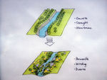
 analytical drawing 1: General impression
 -
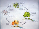 analytical drawing 2: Plants and water in each season
 -
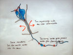 analytical drawing 3: Problems
 -
 analytical drawing 4: Potentials


Projective drawings
- Please add four projective sketches/drawings (or montages/schemes) for your case and take the following aspects into account:
- How would you like this case to change in the near future? (in 1-2 years)
- And how could it look like in 10-15 years?
- Projective Drawings
-
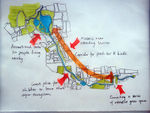
 projective drawing 1: Break the concrete riverbed and bank first
 -
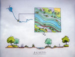 projective drawing 2: Details of the design
 -
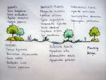 projective drawing 3: Selection of plants
 -
 projective drawing 4: In 10 years, construct a stormwater control system based on the river.


Summary and conclusion
- Concrete riverbeds and sluice gates restrain Changhe River. The river has almost lost its ecological and even recreational functions. This design aims at recover these functions in two phases.
- First, reconstruct riverbeds and rebuild native plant community. Winding and permeable riverbeds not only permit the refill of groundwater but also provide more diverse habitats. On the banks, plant more fruited trees, providing food for local birds and other animals; inside the river, construct a complete aqua-ecosystem to purify small amount of wastewater flowing into the river.
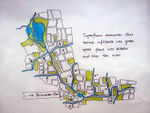
- Second, construct a storm water control system based on the river. Waterlogging caused by storm is a severe problem for Beijing in summer because water cannot infiltrate into the ground anywhere. With this system, rainwater first infiltrate into the ground through the green space network and the superfluous water flow into the ditches leading to the river. This may take some time, but it is necessary to this city.
Image Gallery
You may add a series of images/photos in addition to the sketches/drawings
- Image Gallery
-
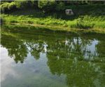 After reconstruction a few years ago, this part has been much "healthier"
 -
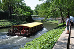 Too many large pleasure boats disturb animals and fish a lot
 -
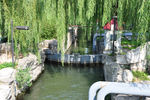 One of the sluice gates
 -
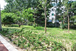 Newly planted trees and grass are dying


References
- [1] Subdivision of Geobotany, Division of Botany, Faculty of Biology. The Vegetation of Peking.Journal of Peking University.1959(02):159-168.
- [2] Turenscape. A Mother River Recovered: the Sanlihe Greenway, Qian'an, Hebei, China. World Architecture. 2012(06):54-57.
About categories: You can add more categories with this tag: "", add your categories