Planting Design 2013 Working Group 13 - Case Study B
---> back to group page working group 13
'''Alder brook woodlands'''
| Name | Alder brook woodlands | |
| Location | Ophasselt | |
| Country | Belgium | |
| Authors | Iwein Mertens | |

| ||
|
<googlemap version="0.9" lat="50.807399" lon="3.892688" type="satellite" zoom="15" width="300" height="250" selector="yes" controls="small" centermarker "yes"> </googlemap> | ||
Rationale: Why is this case interesting?
I chose this 'Image of nature' because I 'practicly' grew up in this reserve, the only thing that separetes my home from this reserve is a little stream. The official name for this kind of nature is Alder brook woodlands or in my language Elzenbroekbos. It's a very interresting form of nature because the largest area of it is "planted" with Alder (Alnus glutinosa) ans Willow (Salix alba, caprea, ...) the main reason why it is a swamp forest and not al normal forest, is because it is situated in an stream valley, and the Belgian - European goverment is using it as an flood sensitive buffer. That means that it's filled with water over 6 months a year, wich creats a specific habitat.
Author's perspective
As a bachelor in the landscape and garden architecture I have an interest in plants and planting design. I find it very interesting that we can find so many different habitats in the nature. 'A swamp' is one of them, my case study handels about an Alder (Alnus) brook woodlands, where the main part of the tree's are Elders (Alnus) and Ash (Fraxinus). Because of the big amount of water in the ground and in the valley you get a specific selection of plants, tree's and shrubs. Only plants with a big water tolerance are doing well in this area, tree's: Alder (Alnus), Ash (Fraxinus), Willow (Salix), Poplar (Populus). Shrubs: Blacktorn (Prunus spinosa), Hawtorn (Crataegus). Plants: Marsh marigold (Caltha palustris), fleur de lis (Iris pseudacorus), and many wild grasses. But the plants aren't the only interesting point in this habitat, the relationship between the swamp and the environment, the surrounding area is even important because al the drain, rain and ground water needs to come trough those specific area's. The reserve is very popular with the locals, schools and clubs. The maintenance in the reserve is done by livestock, Ghaloway cows, in this case. This is a very ecological way of maintaining the area. Those animals don't eat everything they may come across, but selectively eat the plants they like, which results in a very natural and varied vegetation. Unlike the result you get when you use a mower or any other sort of machine. Another advantage on this site is that you do not have to deal with the problem of machines getting stuk in the mud. The only thing missing in this reserve is somekind of footbridge trough the swamp, at the moment there is only a path surrounding the swamp.
Landscape and/or urban context of your case
- The reserve is part of a bigger total of green areas, which is in super vision of Natuurpunt (A non profit organisation funded by the goverment that works with volunteers to keep the reserves 'Alive'. It is situated in a small village of Geraardsbergen, Belgium. The reserve includes a swamp area (my case),and wet meadows. There is a short walking tour of 2.5km and a longer one of 7km. The reserve has two functions, first it's a buffer area for foods and water, because of the reserve natural location the area made it possible to hold water for long periods so that the surrounding towns are more or less saved from flooding. But due to the urbanism problems in belgium there are still a lots of buildings situated in/near the buffer area. The second function it's a recreative area for kids, walkers, and mountainbikers.
- Information charts
-
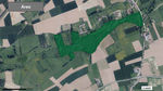 Area of the reserve
 -
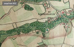 Historical map from 1770 (ferraris atlas)


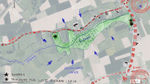
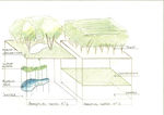
Analytical drawings
- In this case the natural dynamic is more important then the cultural component. In 2010, a monument was placed for the crashed Lancaster airplan during World War II (may 1944).
- "The different elements" From the sketch can see, that there is a big difference between m°1(part that floods) and m°2(part that keeps dry). Not al the areas are constantly flooding what depends on the season, human interaction, ... The sketch shows what happends to the area when there is surface water or when it's "dry.
- "View into the seasons" Through the four seasons, the biggest difference is between the summer and the winter. The Summer is the period when there is hardly any surface water, simply because it doesn't rain enough in those months. There for we get a different vegetation, more green (groundcover) eg. Filipendula ulmaria. In the Winter there is almost constantly surface water (starting in the Autumn), wich reflects on the flora, what is degrading week after week. More water = less plants. If we analyse that you can see that there is an ecological cycle that keeps the nature and swamp in balance.
- Analytical Drawings
-
 Analytical drawing of the cultural/urban context
 -
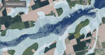 Flooding area's from a less frequency (light blue) to a very high frequency (dark blue)
 -
 The different elements
 -
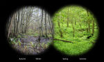 View into the seasons


Projective drawings
- The case is now already a very good "reserve", it's ecological and with natural succesion, but due there is only one walking path it's very unfortunaley that the visitors can't see the "heart" of the swamp. There fore my proposal of the "wooden bridge project". Not only for the eye, but also for the knowledge of nature that most of the visitors dont't have
- View into the future: The reserve as a whole, will be more important for the people in the direct environment and tourist (walking-mtb) because of the more and more densely built city's their for more vulonteers will help to save the green places and financially support the organisation (Natuurpunt http://www.natuurpunt.be ). It will be a free, stressless environment in the grey world. The monument for the crashed canadian airplane during World War II wil be memorial place for the family of those who gave their lives to protect there children.
- Projective Drawings
-
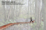 Proposal
 -
projective drawing 2
-
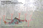 Memorial monument
 -
projective drawing 4


Summary and conclusion
From my point of view, as a landscape architect the reserve doesn't need a big structural change or design. Often you can do more with a few small changes then with one major project. What I think is the reserve, area is missing is a walking path through the Alder brook woodlands (today there is only a walking/maintenance path on the outside of the reserve). As you can see in my first projective drawing I am suggesting a wooden footbridge through the brook woodlands. Which will increase the cultural interaction from the neighbors and visitors as well the educational part. The second change I would do is creating a bigger place for the monument of the crashed Lancaster from World War 2, today its situated on the edge of the reserve next to the road. My first suggestion is to create a memorial monument at the place of the crash, in the middle of the reserve. It would strenghten the band with our allied nations and add a direct link with the history of the park.
Image Gallery
You may add a series of images/photos in addition to the sketches/drawings
- Image Gallery
-
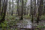 image 1
 -
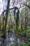 image 2
 -
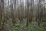 image 3
 -
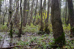 image 4


References
- www.natuurpunt.be
- www.agiv.be
About categories: You can add more categories with this tag: "", add your categories