Planting Design 2013 Working Group 11 - Case Study A
---> back to group page working group 11
Please add the title of your case study here, adjust the map coordinates and replace the moa image with a characteristic image of your site
| Name | add name | |||||||||||
| Location | add location | |||||||||||
| Country | add country | |||||||||||
| Authors | add author | |||||||||||

| ||||||||||||
| {{#widget:GoogleMaps | width=300 | height=200 | lat=71.295556 | lng=-156.766389 | zoom=8 | centermarker=yes | maptypecontrol=yes | overviewmapcontrol=yes | largemapcontrol=yes | scalecontrol=yes
}} | ||
Rationale: Why is this case interesting?
LGS in german stands for Landesgartenschau which is an exhibition about garden and green areas that takes place in different german states every year.
Generally, the LGS 2012 in Nagold city is considered a success, has improved the green infrastructure in the city and also met public interests.
Some changes in the final project and implementation reveled that the mutual participation between public and planners was limited in the planning process and lead to reactions in the final decision.
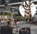
Baubotanik is a special aspect in Nagold, where the Platanencubus experiment represent the biggest bio-construction in a urban context.

Author's perspective
As an architect getting experience in Landscape Architecture field, I'm interested on public spaces planning and management. The success of such projects is directly related, among other aspects, to the ability of planners to meet users expectations and create sustainable places. In this project it interesting to reflect about public participation in the planning/desiging process, as many design ideas were adapted or changed according to public reaction. Understand users needs and expectations is essential to create sustainable spaces which are effective used and preserved.
Landscape and/or urban context of your case
- Biogeography, cultural features, overall character, history and dynamics
The 2012 Nagold Landesgartenschau was a strategic platform to redevelop the city through the extensions of the inner
city by remodeling its green spaces and parks, connecting and integrating the green infrastructure into the city center, restoring river vegetation. The competition, won by Landscape architect Stefan Fromm, considered the following requirements:
- Improve the riverbanks ecosystem and conditions
- Integrate the historic city downtown into the Landesgartenschau and later to the green corridor
- Link the Hohennagold castle to the green infrastructure
- Propose an efficient area of garden exhibition that could eventually transform into new housing quarters
- Connect the inner city extensions to the downtown through this new green system
- Adequate the existing parks into the new city’s development concept

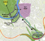
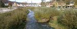
The project takes this green corridor as the core idea of the whole design in which the integration bridge is the Waldach River, which crosses the city from north to south. The project itself begins at the Zellerschule (Zeller School) and travels south t the Viaduct, an important landmark in Nagold landscape, which also divides the inner city extension to the periphery. The Waldach River had to go through intense revitalization since a part of it was covered by a concrete surface next to the town’s bus station. It’s path along the city was also in very poor conditions so the decision of the Landscape Architect was to make the river go over the process of revitalization to keep it’s wilderness character inside an evident trapezoidal geometry that embedded the bank from North to South. Along the river, a promenade was made to improve the communication between citizens from different neighborhoods. These promenades also connect the existing reconditioned parks to the historic city’s downtown. At the “Waldachkopf”- the point where the Waldach River and the Nagold River meet each other, the promenade becomes a small square destined to give the welcome from the downtown to the new open space concept. Sitting steps are located at the river border of this nature stone pavement. A Café Bistro is the limiting element of this surface that functions more as a sitting space as a transition element. This part of the promenade connects to the Stadtpark, located at the other side of the river through a concrete bridge crossing exactly on the top of the meeting point between the two rivers in the Krautbühl Park’s edgy corner. The pedestrian concrete bridge also has the peculiarity to go over a viewing platform located at the water level of the river that embeds a metaphoric sculpture of the meeting of two rivers symbolized by the subtraction of a man’s silhouette from a rectangular steel element.
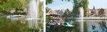
At the end of the bridge the visitor enters the Stadtpark (City Park), a park with various functionalities as sand and water playgrounds at the north of the park, a small train for little children which goes along a vast grass surface and perimeter pathways accompanied with (Platanen) that repeat the form of the contour of the green surfaces. These long perimeter pathways connect with shorter strait pathways that cross the park in the shorter section. The western edge of the park is meant to be a transition and contemplation area between the Schlossberg, a mountain considered as nature conservation area, and the park itself. Fromm designs an elevated terrace that runs along the silhouette of the hill and builds gabion walls - without affecting the natural course of the ecosystem- to retain the water that runs into the Waldach River. An Ingenious solution from Fromm was to use this water to run through the playground area and integrate it into the games and geometric definition of the space. The terrace itself has a defined shape bordered by hedges that run along the whole terrace on the border and garden beds distributed geometrically in the inside of it. The terrace also connects to the Schlossberg by some stairs located at the middle and end of the terrace extension. These stairs eventually join the previous pathways that direct you to the castle ruin. The end of the terrace is also a small gravel surface with a structure of birches and a café in front of the swimming hall at the left and an entirely new mini-golf at the right. From the end of the terrace there’s a visual connection to the ancient Celtic Krautbühl grave in the Krautbühl Park at the other side of the river. As the visitor abandons the terrace, he takes a straight path that borders the project and gives an overall look to the mini-golf and the open theatre located near the riverbank. Then, he crosses the metal structure bridge to get directly in front of the Celtic grave hill, which is the most important green element of the Krautbühl Park.
The Krautbühl Park is smaller in comparison to the Stadt Park but has more garden surface. The grave hill is the main axis of this park and is metaphorically simulated by the ecumenical green church at the other side of the park. This open church with Corten steel sits has a circular shape like the Celtic grave’s shape. The somehow narrower contour of the Krautbühl’s Park forces the whole progress of the program to be linear, so the offset pathway surrounding the Celtic grave ends with a straight path that crosses the whole park and defines a rectangular and thematic garden structure at the right of the path and a grass open surface at the left. At the river border of the park, a row of Platanen is collocated parallel to the riverbank and a wood promenade in the bottom part of the riverbank with rectangular wood-block banks to sit and contemplate the Nagold River. The spark limits at the south with a new residential development, which clearly will benefit from the improved open space infrastructure of the river in the downtown’s side.
Crossing the revitalized river through the nature stone paved promenade and the improved existing pathways that go under street bridges and run along the riverbank, the visitor gets to the new park at the south, bordered by the viaduct. This park split by the Waldach River tries to connect both sides by an oval shape which also relates to viaduct’s curvy contour and its notable concrete arcs. Inside the Oval Forum, a set of playgrounds and activities is designed to fill its content. At the left side of the Waldach, the perimeter of the oval is emulated into concrete offset sitting steps that could eventually be used as another open theatre. In the center of the Oval Forum a temporary spherical wood structure is found which park. The right border of the park ends again in the concrete bridge that connects the promenade with the two parks and forces the visitor to move along the remains from the Gartenschau and was used to host a recycled art exhibition but after and despite the will of the city planners to demolish the structure, the citizens wanted it to remain till it eventually falls down. At the other side of the Oval Forum, some low gabion walls are also used to define the different functions inside the oval, as well as bringing uniformity to the overall concept of the green backbone, since they are also used in the Schlossberg. Most of the playground is found in this side of the Oval Forum. The connection of the two parts of the Oval Forum occur thanks to the existence of two small pedestrian bridges. The south border of this park is approached as sport fields and basketball courts. Despite the dominance of the oval forum on the park, the perimeter is being developed in a more rigid structured way to host new residential buildings that occupy the former theme exhibition gardens. In this part, another important attraction of the park remains with less success, the Platanenkubus, a temporary metallic structure that gives shape to a series of plants that grow surrounding the structure and that will (if it has success after 5 years) bond with the other plants in this structure to hold the viewing platforms and interior paths now supported by the metallic cubic structure. The experimental technique that consists of buildings supported by vegetable structures is called “Baubotanik”, and was discovered by Ferdinand Ludwig.
Observing the whole network of parks and promenades used to connect Nagold’s neighborhoods and the concept success to bring back the landscape to the town as well as making it attractive again to the citizens to stay. One must admit the level of vision the city planners had to reorient the current situation Nagold was affronting before the Landesgartenschau. 11 years had passed since the vision of the project was established, and still there are some current residential constructions related to the plans taking place, which infer the long duration of these projects and sustainability they can go over time.


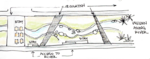
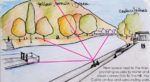
Analytical drawings
Please add four analytical sketches/drawings (or montages/schemes) of your case and take the following aspects into account:
- natural dynamic versus cultural framework - in how far do these two forces come together in your case?
- dynamic through the year (you may imagine how the site looks in spring and summer, maybe you also remember it)
- highlight potentials and problems
- Analytical Drawings
-
 analytical drawing 1
 -
 analytical drawing 2
 -
 analytical drawing 3
 -
 analytical drawing 4


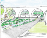
Projective drawings
- Please add four projective sketches/drawings (or montages/schemes) for your case and take the following aspects into account:
- How would you like this case to change in the near future? (in 1-2 years)
- And how could it look like in 10-15 years?
- Projective Drawings
-
 projective drawing 1
 -
 projective drawing 2
 -
 projective drawing 3
 -
 projective drawing 4


Summary and conclusion
Please summarize your case and give arguments for your projective design (approx 150 words).
Image Gallery
You may add a series of images/photos in addition to the sketches/drawings
- Image Gallery
-
image 1
-
image 2
-
image 3
-
image 4
References
* Please make sure that you give proper references of all external resources used.
* Do not use images of which you do not hold the copyright.
* Please add internet links to other resources if necessary.
About categories: You can add more categories with this tag: "", add your categories