Pictures of our Landscapes IMLA Group
---> Back to overview of groups
Fernando Bujaidar Teruel
Images


Description
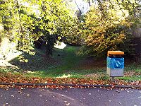
See Promenade (Lakeside Walk), Überlingen am Bodensee, Germany. This picture gives us a very good idea of how the different elements come together to create a landscape. On the left side we can see the Konstanz Lake (Bodensee), which is itself very peculiar, given that is the point of union between 3 countries: Germany, Austria and Switzerland (4 if we count Lichtenstein), it is for this cause, that the region has a very rich cultural exchange, and therefore it is quite unique. On the center of the frame, there are a lot of trees of many different kinds, their variation of color gives the picture a warmer tone, contrasting with the coldness of the water, the sky and the walk path, this colors can be seen during the autumn, this is also important for it reminds us that the landscape can be easily changed by nature, more significantly, and more rapidly than the human hand. Finally, on the right side, lies the walk path and there are also some buildings, the path is used by many people every day, but it can have a very different signification to each person, for some it can be a medium of work, for some others it can be just a relaxation point, and so on, this also comes to affect the way people feel about a landscape, the meaning it has to them.
Überlingen Bahnhof (Überlingen Train Station), Überlingen am Bodensee, Germany. There is one main point to this image, and that is the mix of the old and the new elements, we can see that the main construction of the train station and the tunnel are very old, and yet there are some elements that are, lacking a better word, younger, also, it’s shown how the nature have come to play an important role in this urban landscape, it’s possible to see in the right side of the picture, how the plants have grown all over the wall, merging into one with it, another reminder that nature is not easily tamed, actually, the fact that the station is shaped the way it is, was affected directly by nature, it is built in a depression that has been there before there were any humans around. Once again the visualization of the landscape will depend on each person, no one will feel the same, or see the same in this place, so this is not one landscape, this is an endless amount of them, as many as there are people around it.
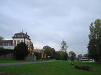
Panoramic view, Überlingen am Bodensee, Germany. In this photo nature does not play a very important role, it is more of a urban landscape, nonetheless, it is important that we acknowledge that it was probably nature that made this landscape the way it is, because, human kind since ancient times have had to adapt to the natural conditions of his habitat, and so have he shaped his surroundings, turning them into what we see, feel and live today. And even when nature does not appear to have a strong presence in this picture, it is there, because man cannot remove it completely, for he can’t live without it, and even when man continues to make bigger and bigger buildings, it will never be able to let nature completely out of frame. Nature is everything, even when man changes its shape, everything we see in this picture is nature, the houses are made of wood, the church we see right in the center is made of stone, and so on, every element is just nature transformed; maybe men should pay more attention to the ways of nature, so we could optimize its uses, affecting it as less as possible.
Seah Wei Ping Gabriel
Images


Description
Chinesischer Turm (Chinese Tower)
Located in the heart of the English Garden (Englischer Garten), Munich, the Chinese tower was built in 1789-1790, as a performance platform. (http://en.wikipedia.org/wiki/Englischer_Garten)
Till today, the Chinese tower still entertained its visitors and guests with traditional music from the brass band and beers from one of the earliest brewery in the region. Housing a spectacular seating space of more than 7000 people, it is set to create an all year round Oktoberfest atmosphere. (http://www.cityscouter.com/travelguides/munich/Chinese-Tower-Chinesischer-Turm.html)
As one of the most frequently visited attractions in Munich, the Chinese tower is a popular social gathering space, both for the locals as well as foreigners. Together they drink; chat, sing and dance, under the Chinese tower in the English garden of Munich, Germany. To find such a Chinese pagoda in such context is ironic, but nevertheless, it provides the vast park with a distinctive landmark. Which otherwise would be a real challenge for the visitors to find their ways or even to set a place for meeting.
Also the language of the Tower narrates the possibilities that cultural influence of the Chinese once swept across this land. Creating immense fascination that inspired Architects to construct a 25 meter high tower in the middle of a European city.
Although the Chinese architecture physically dominates the space, the local culture remains as the soul of the place. In other words, the actual atmosphere is still formed and shaped by the Bavarian living habits and lifestyle.
Marienplatz(Munich City Centre)
Known as the city centre of Munich, it served as an important public square to the city since 1158, hosting various important social events. (http://www.aviewoncities.com/munich/marienplatz.htm)
Today the square is dominated by the gothic style architecture of the new townhall, built in 1867 - 1909, it was the solution to the overcrowded old townhall back then. (http://www.aviewoncities.com/munich/marienplatz.htm)
Inhabited by shops, traditional restaurants, souvenir kiosks and the fact that it is the old city square, Marienplatz earned itself the title as a ‘must visit place’ in numerous travel guides . However, these are the only reasons which explain the thousands of people visiting daily.
Well connected to more than 3 busy subway stations, all within comfortable walking distances. Like our vital body system, they depict the arteries to the heart, making circulations through the square natural.
Besides that, varieties of businesses and activities flood into the square, resulting in a lively and vivid atmosphere, which is able to attract and retain the crowd. These also act as a relief to the network of busy streets, creating a pause to the dynamism.
One clear example of the effect can be seen daily during the 1100, 1200, and 1700 hours. At this time of the day, figurines within the famous Glockenspiel perform 2 traditional stories dated back in the 16th century, entertaining the hundred of audiences in front of the gothic facade for a whole quarter of an hour. (http://en.wikipedia.org/wiki/Rathaus-Glockenspiel)
Marienplatz was of course not spare from modernisation but despite the increase of modern shop fronts and contemporary architecture languages, traces of the past are still highly visible and significant. Historical buildings, old streets paving and even old town drainages are retained. Therefore, the possibilities of the experiencing old city charm of Munich today.
The Hofgarten (Court Garden)
An Italian renaissance Garden in the centre of Munich, Germany. It is located between the Residenz and Englisher Garten (English Garden). Within the garden are series of pathways, organized in a formal manner, creating a symmetrical layout. Positioned in the middle of the garden is a pavilion, dedicated to the goddess Diana. Further suggesting its importance, eight paths were directed towards the pavilion, forming a focal point in the landscape.
Created by the symmetrical walkways, voids in between the paths were carpeted with lawns. These lawns provide recreational spaces for socialization and relaxation.
While in the Hofgarten, one can experience the unique spatial experience of being in a formal garden enclosed by significant buildings and monuments. It is thus, also a quiet getaway from the busy city streets. (http://en.wikipedia.org/wiki/Hofgarten_(Munich))
Carla E.Tosso
Images
-
 KarlsPlatz
 -
 KarlsPlatz Bahnhof
 -
 Schloss Nymphenburg


Description
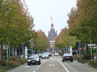
IMAGE 1: Karlsplatz (Stachus)
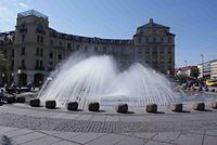
Karlsplatz or most commonly known as Stachus(1) is an iconic Fountain that marks the beginning of the pedestrian zone of the center of the city. This axis also leads to the well-known centre of the city or Marienplatz, the beginning of this axis is clearly marked with the old western door of the city named KarlsTor(2.
This entrance is very important, you can clearly feel that the environment changes with a lot of shops, coffee places and bars along the way, the people in Munich enjoy this spaces on a daily basis for a stroll with their families, having a drink or a shopping spree.
The buildings surrounding Karlsplatz towards Marienplatz have a great architectonic value even though this buildings have certain high, you never feel enclosed or dominated by them they have a very good merge with the existing vegetation and the architectural elements as churches, offices and business that you find along the way, the vegetation that exist consist mostly of trees along the way, these provide confortable shade in summer and are part of the environment which are very important for the people that relate to nature in several ways as parks and open spaces.
The most important thing about Karlsplatz that is an important reference point of the city, and is used as a space to start your day or simply sit there and enjoy a drink and look at the surroundings.
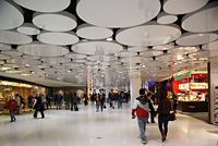
IMAGE 2: Karlsplatz Station
Karlspatz Station is underground of Karlplatz, as we can clearly see in this Picture there is no relationship with natural landscape or any form of vegetation, all we can see an urban landscape.
These stations are part of the everyday life of the people in Munich as the public transportation is the most used form of transport in Munich. This station in particular is very modern, the reflection in the ceiling as one passes makes the way more interesting, all around the station there are shops and places, the people traveling can stop to have something to eat or have a quick coffee, this is very important for the smaller business that provide this services, and also for the people that uses them.
As for the design and the relationship with the outside I think it will be very interesting to incorporate at least the spirit of the outward spaces in, and backwards, so it won’t feel like is completely disconnected from one to the other.
The Station is used every day and it reflects the necessity to have well equipped and efficient spaces for the people, this station in particular shows a little bit about modern architecture that is not seen around the center mostly because of all the historical buildings, I think is a very good merge between the two of them and if it could be related to the exterior somehow it would be even better.
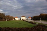
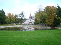
IMAGE 3: Schloss Nymphenburg
The Nymphenburg Palace is a Baroque palace in Munich. The palace was the main summer residence of the rulers of Bavaria.(1)
This Palace is one of the most famous sights of Munich, the gardens have a Formal Style that can be clearly recognized by the symmetrical form of the planting, each side is exactly as the other, also the use hedges very carefully clipped and several forms make us recognize this peculiar style of garden widely used in palaces as Nymphenburg.
As we approach to the palace we can clearly see a canal that has 2 big lakes prior to the entrance, this canal marks the axis that will we used as the reference to have the mirror effect that I mentioned before.
This palace is also the home of the well knowed botanical Gardens with species from all over the world. The importance of Nymphenburg is both cultural and economical, the cultural part is that even is a historical place that shows important part of the history of Munich it is seen mostly as a public space that can be used for several activities as sports or leisure, the people of Munich appreciate the open spaces and they use them on a daily basis.
The economic benefit of this park is that it attracts tourists everyday looking to learn a bit more of Munich history, and it’s considered a place you can’t miss while you are in the city.
The most important issue is that we could consider this space as a refugee for a busy city life as you get in the park you cannot longer see the city due to the great amount of trees and vegetation, showing the importance of nature in the everyday life of the people in Munich.
Adham Momtaz
Images
-
 Pedestrian Crossing - Downtown
 -
 Green Belt - Uptown
 -
 Separation - Town Edge


Description
In as much as the following presentation is about a town along the Bondensee it is also an attempt at bringing out or highlighting certain issues pertaining to the practice of landscape architecture in our day and age. By portraying certain landscape aspects from my ‘internship’ town, and additionally using this presentation as a space to highlight important notions that shape my own personal understanding of future concepts, i try to open the space of this forum to the interpretation and questioning of certain established norms of habitation, particularly the relationship between the built and the natural, as well as the future of urban landscaping and what it entails in the relationship between Architecture and Landscape, in hope of shedding some light, an understanding, and a standpoint for developing my own personal ideology in landscape architecture.
Überlingen City is located at the southern most part of germany, a small town that lies along the southern shores of Lake Konstanz, which itself is shared with Switzerland and Austria. The town has 10,000 inhabitants, almost 10 times more than any other city in Überlingen county. Its inhabitants have been terraforming its cliffs and shores since 300 B.C. The biggest part of Überlingen City is nestled between an annex of the Alps mountains and Lake Konstanz. The downtown area and epicenter of its urban sprawl are located just next to the lake’s shore as it continues to expand southwards and outwards towards the mountain range.
For this presentation i have decided to present three images selected for their physical range and interrelatedness; all the way from the fringes of the city to the highly urbanized area closer to the town center, thus manifesting some of my concerns and interests as a landscape architect; where in most cities these fringes or edges form a battle ground between the natural and the built form.
Following the industrial revolution, cars took to the streets; polluting our habitats with chemicals, noise, and extreme hazard. Our introduction of this malignant utility into our cities has further helped de-shaped the way our cities look and feel. Commercial real-estate efficiency as well as the need to navigate our vehicles through what once a pure pedestrian domain (the traditional town) have rendered most of our cities very much alike and all following and orthogonal grid system. Although limited to 3 photos throughout this presentation, i wish to question the relationship between roads and the natural landscape, as well as the relationship between architecture and the geography of landscape systems.
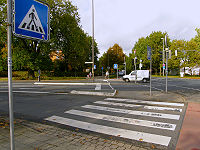
Photo no.1 - A Typical Crossing - Close to Town Center
In this first image, taken close to the town center, we see a typical road-crossing, the lifeblood of any contemporary urban, suburban, and even rural landscape; the only tool, without which they would cieze to work altogether. This photo portrays the immense number of edges that could intercept and harm a pitiful pedestrian as he navigates his city or town. There are roughly 10 horizontal edges to traverse only 10 meters of urban space, if we were to just count the different ground textures that comprise this landscape. There are also around 20 steel poles with sharp signs and signals in this small vacant area just to control the different types of flows across it. The complexity of the relationship that currently exists between our landscapes and the vehicular flow that we have vowed to continue to allow to intercept our cities is explicitly evident in this photo.
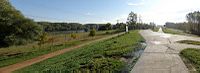
Photo no.2 - A Green Belt - MiddTown
This next image, taken midway between the town-center and the edge of Überlingen displays a gentle natural passage; a park-like natural ring that surrounds the city, it is comprised of soft-sloped natural mounds where the valleys form a continuous network of passages connecting the different parts of town together in a formation that is so pleasing to walk through. If we compare this kind of “pedestrianism” vis-a-vis the previous photo we come closer to re-thinking the open spaces of our cities, even the basics of whether vehicles are as necessary as they seem to be for creating vital cities.
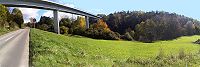
Photo no.3 - System Separation - Town Edge
In the next image, shot at the peripheries of town, we see the landscape formed by the hills that surround the city of Überlingen, the gentle slopes again form a network of ‘pedestrian-possible’ routes connecting most parts of this beautiful and lively suburbia. A floating bridge overhead carries traffic along the periphery of this town in what seems to be a healthy relationship between nature and the built form. The bridge does not disrupt the natural flow of nature or humans underneath, leaving the ecology healthy underneath it.
Through the above selection criteria was, not only used to portray, but also in order to bring out different questions that contemplate our rethinking of Landscape Architecture and the future of open space;
- Are cars integral to our urban lifestyle, if yes, then how about Katalhoyuk, one of the first human settlements with continuous connected outdoor cityscape, utilizing the roofscape of all the town’s houses?
- What would become of the urban grid if we removed cars from our cities? Particularly when Architecture and Landscape are seamlessly integrated?
- Can we stop urban sprawl and rethink our urban centers in light of the pedestrian?
- Can the space, originally reserved for cars (streets, parking area, etc) be re-inhabited?
- Can our cities truely become edgeless?
Giselle Gurgel and Suranjana Datta
Images
-
 Schloss Phillipsruhe
 -
 Castle park
 -
 "Aue" between Castle wall and river


Description
Schloss Phillipsruhe (Phillipsruhe Castle) in Hanau, Germany was built by the Count Phillip Reinhard and its construction began in 1701. Located in Kesselstadt, to the west of the city of Hanau, it is on the bank of the river Main.(1)
The Phillipsruher Allee (Phillipsruhe Avenue), which runs along the river, has the castle as its focal point. This major axis continues in the castle garden, signifying the importance of the castle which is placed centrally on its large and flat ground. This geometry of the road and the garden is influenced by the presence of Schloss Phillipsruhe.
The high wall running along the boundary of the castle grounds confines its landscape within the boundary, with no connections to the river which flows to the right of the castle. The man made water body behind the castle with no association with the river illustrates on the attempt which was made to glorify monarchy and the monarch’s dominating and manipulating character to show his authority, wealth and power over nature.
Since Hanau required more recognized recreation places in the city, the ‘’Aue’’ (floodplain and natural form of vegetation along streams and rivers) of Main serves for sports, children’s park and other outdoor activities. Although this Aue includes in its area the land between the castle wall and the river, and these places are physically connected, they are visually not connected. This area with this new use: new needs of recreation for the city’s people, contrasts with the old and authoritative representation that the castle and its wall projects.
The different pictures show three different aspects of the castle, but all of them are connected by the importance that it and its owner had projected. The castle is strategically placed both in terms of waterways and roads; as a direct focal point of the road or as a powerful image seen from the river. On the other hand, the landscaped park along with the water body in the castle grounds was created for a more private use of the owner, for him to appreciate his own grandiosity and acquirements.
In today's context; the castle serves as a museum in its main building since 1967, showcasing different aspects of local history. It's garden is also host to seasonal horticulture shows, and cultural shows including the Brother Grimm Fairytale festival are experienced in the amphitheatre in the castle park.(2) So eventually when monarchy was abolished, the monarch was replaced by the common ordinary man to use and appreciate all of these.
- (1) Source - http://de.wikipedia.org/wiki/Schloss_Philippsruhe,
- (2) Source - http://www.hanau.de/kultur/museen/index.html
Balázs Dukai
Images
-
 River Tisza
 -
 City center
 -
 City border


Description
Each of the three pictures shows a part of Kanjiza city and it's surrounding. The small city with a little above 10.000 inhabitants located in north Vojvodina (Serbia), along the river Tisza. The area lays in the temperate zone with clearly continental climate, it is part of the Great Hungarian Plain geographic region. The native vegetation here is mainly made of grass species, the deciduous woods are mostly located along the river. The geographical features are very favorable for the agriculture therefore it plays an important role in the area's economy. Many people still living from agriculture (especially animal breeding and cereal cultivation), or do it as an income supplement. So the hundreds of years of cultivation made a huge impact on the contemporary landscape.
River Tisza
The picture shows the city's connection with the Tisza river. I have chosen this site because of the rivers importance in shaping it's environment. It physically forms the terrain, influences the local climate and creates emotional reactions, bounds in the people living by. The picture is made on the dam which is frequently used by locals for recreation (walk, run, etc.). The beach (in the left side of the picture) is underused, actually not really inviting, to the right side, after a few hundred meters of flood area the city core begins.
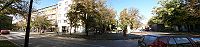
City center
The picture shows Kanjiza's city center. I have chosen this site because nearly all people lives in some kind of a settlement, maybe what a surrounding a child firstly see, percepts and grow up in, is a settlement, therefore it can be determining in their life, furthermore maybe most social interactions happens in a settlement. Mainly the city is the place where we decide what should happen with the landscape, the rural areas nearby so what quality a city has, it can be similar in the connected land. In this case the city shows poorness. The design of the center is moderate, in the first place stands functionality. Only few people use it as a place for strolling and chatting.
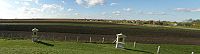
City border
Peri-urban area, picture is made from a sacral monument (ca. 10 meters high hill) towards the rural area. I have chosen this site because the fields are determining the rural landscape. Similar picture can be seen when traveling across this land. This area shows the connection between the city and it's environment, the fields and houses are mixing here what shows a gradate transition, locals living here have stronger relation with nature than elsewhere.
Nemanja Markovic
Images


Description
As an answer to our first assignment, 'Pictures of your Landscapes', I was mainly focusing on social aspect of Munich landscape. These pictures represent my view of what is unique and special about the way Munich residents spend their free time. In a way they also speak about people's passion, their habits and lifestyle.
Even though Munich residents, in other parts of Germany were known for their very conservative and religious lifestyle, now it seams different. As far as I could notice their free time is more oriented towards, drinking bear, having fun, doing sport and spending a lot of time in nature.
In each one of these photos you can see connection between people, nature, sport, and beer.
- First picture represents people’s devotion to nature; it is about people’s lifestyle.
Nature is a part of everyday life here in Munich. There are many parks and gardens such as: Olympiapark, Westpark, and the parks of Nymphenburg Palace. In Hirschgarten for instance, besides having fun in healthy green environment you can actually see free deer that live there, even though the garden is considered to be in urban environment. English Garden is one thing that makes Munich such a pleasant city to live in. During the summer you will see students from the adjacent university studying here. Other people play football, Frisbee, horse riding, play cricket and surfing on the Eisbach river! Particularly notorious activity is sunbathing in the nude. In the area in and around the horse track (near University) it is permitted to strip off naked. In Germany this is called FKK (Frei Körper Kulture = Free Body Culture).
The Munich English Garden is a huge park which stretches alongside the river Isar from almost the very center to the northernmost rim of the city. English Garden was created in 1789 by the British physicist Sir Benjamin Thompson, the count of Rumford. Park covers 3.73 square kilometers which makes it the largest city park in Europe and larger than New York's Central Park (3.4 square kilometers). [1]
- Second picture represents people’s passionate relations to sport.
The most popular sport in Munich is football for sure. Two of the world largest stadiums are located in Munich (Munich Olympiastadion and Allianz Arena) and together can host more then 135.500 spectators. Allianz Arena hosts Bayern München football team; their fans are known to be very passionate and cheering. But on the picture you can see surfers. They surf on Eisbach river that floats thru Englisher Garten. Even though when I think of surfing the first thing that pops into my mind are Hawaii or similar exotic islands, these enthusiastic young people proved me wrong. Considering the fact that middle European climate is not always very supportive to this kind of activity, I was quite impressed by their skill and passion, so I had to present them instead of football fans.
- Third picture represents ordinary common people in a beer garden who drink bear, have fun, talking to each other, chatting and telling jokes.
Munich is also known for hosting Octoberfest- biggest beer drinking event in Europe. It last for 3 weeks (sometinmes 4) and it attracts millions of tourists every year. Beer garden is an open-air area where beer, other drinks and local food are served. It is usually attached to a drinking establishment such as a public house or a beer hall, which in places such as Munich may serve large numbers of customers. The biggest beer garden is in Hirschgarten it can serve up to 8,000 people. [2]
Beate Scharbach
Images


Description
Picture 1: City center
The first picture shows the city center of Freiburg. It is famous for its “Bächle” (runnels). In mediaeval times they were used to serve the city with fresh water. They were never used as sewers, like most people think. Freiburg is one of the warmest areas in Germany. Therefore people like spending their time outside. Every little café or bar has some tables and chairs outside. People like to do outdoor sport. Running, walking, hiking, cycling are very famous. Some people also do fancy sports like parachuting, climbing or golf. Freiburg’s habitants are very environmentally aware. Statistically every habitant owns 1.1 bicycles. The public transport system is developed very well. Many people only buy organic produced food. The mayor is a member of the “Green” Party.
Picture 2: Heliotrop
Freiburg is known as one of the solar cities of Germany. Some call them even “ecological capital”. With 1800 hours of sunshine a year it is one of the sunniest areas in Germany. The district Vauban is an ecologically designed settlement of 2000 houses. 50 of this are solar houses which will produce more energy that they can consume. This homes use only 15 % of the energy that is needed by Freiburg`s low-energy homes. The city and whole region around Freiburg are full of houses whose owners have installed solar systems for electricity or hot water on their roofs.
The house on the picture is called Heliotrop. It can rotate to have always the best fitting angle to the sun.
Picture 3: Area around Freiburg
The third picture shows the area around Freiburg. The countryside is hilly. Freiburg is placed in the “Rheingraben”. This area arose by the reason of the last glacial period. The today called river “Rhein” formed a broad valley. The area borders westerly on the river “Rhein” which runs from south to north and easterly to the mountains “Schwarzwald” (known as Black-Forrest). The “Rheingraben” is densely populated. The flat areas are used for the cultivation of grain, vegetables and fruits. The southerly-facing areas on hills are used for viticulture. The more mountainous areas were used for the cultivation of timber. In former times the fields were very small and there were a lot of shrubs and little trees along the country lanes. Areas which were to wet, to dry or to precipitous weren’t cultivated or they were used as pasture land. But when big agricultural machines were introduced the fields increased. Backwards uneconomical areas were utilized, the biodiversity decreased. Today, the Nature Conversation has many programs to save precious areas and to assure the connections between existing and reconstructed habitats.
Umut Özdemir
Images
-
image title
-
image title
-
image title
Description
Please edit your text here...