Passing Landscape in Bornova
---> back to overview of Case Study List
A Knot Point of Passing Landscape in Izmir, Turkey
| Name | Passing landscape | |
| Location | Izmir, Bornova | |
| Country | Turkey | |
| Authors | Isin Barut | |

| ||
| <googlemap version="0.9" lat="38.273416" lon="27.124868" type="satellite" zoom="12" width="300" height="250">
</googlemap> | ||
Short Introduction to the Area of Study
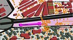
There are some knot points in the transportation zones. I call them transportation knots in the landscape. We actually frequently come across with transportation knots. Izmir is one of the most populated city in Turkey. Further more Izmir is heavyly urbanised and showed dramatical changes in road infrastructure development. There are many transportation knots in Izmir city. One of them is located in Bornova which is a kind of intersection point where the Ege University Campus Entrance, Bornova Metro Station,a Major Road:Ankara Road and the Bornova Bus Station meet. There are many students who pass that landscape every day to enter the Ege University Campus. The accessibility in the area is low and it is dangerous to pass that point. People who come across everyday landscapes in mega cities generally do not recognise the landscape just becouse of recognising that landscape as a passing area.Ironically transportation knot points also a kind of meeting point. Bornova transportation knot point need to be recognised and should become more than a passing area to recognised everyday landscape.
Exercise 1: Sketching the Landscape
Time frame: October 25 - November 15, 2011
Student activities:
- Creation of analytical drawings and sketches
- Presentation of results
Please upload a selection of your drawings/sketches/mental maps and add them to the image gallery
Sketches and Drawings
-
 Function Diagram
 -
 Passing landscape
 -
your image text
-
your image text
-
your image text


Exercise 2: Landscape Layers
Time frame: November 15 - 29, 2011
- time based changes and 'landscape biography', and/or:
- topography, open spaces, built, green, traffic and water structures on different layers. *Definition of zones with coherent character
- Description of this character.
-
 Road infrastructure in 1984
 -
 Road infrastructure in 1990
 -
 Road infrastructure in 2000
 -
 Road infrastructure in 2009
 -
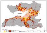 Urban Development in Izmir


Please publish your findings here
Exercise 3: Behaviour Patterns
Time frame: December 6 - 20, 2011
- How do people behave in this area? How do they use the space? What is important for them?
- Observation of study area, interviews with local people and mapping of use patterns.
- Preparation of short presentation
-
 Users and Activities
 -
 Users density
 -
your image text
-
your image text
-
your image text


Please publish your findings here
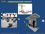
Exercise 4: Communication Concepts
Time frame: December 19, 2011 - January 17, 2012
- Based on the different landscape assessment approaches students will develop a communication concept for their area of study
- Which measures would be necessary for enhancing the awareness for the area?
- Students are free to choose their method.
Possible Communication Concepts
-More attractive, interesting and functional area(art works, colorful benches, new waiting place for some activities like music boxes that people can enter and listen music
-More safety pedestrian passing/new underground passing-especially for students
-
-
 What to communicate?
 -
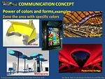 How to communicate?
 -
 How to attract?
 -
your image text
-
your image text


Please publish your findings here
Image Gallery
-
 An image from the paved road of case study area.
 -
 An image from the entrance of the university.
 -
 An image from the Bornova Train Station.
 -
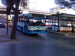
 An image from the bus station.
 -
 An image from the area.


References
http://www.izmir.bel.tr/en/default.asp
http://www.trendhunter.com/trends/metaform-pedestrian-bridge
http://www.uslanmam.com/sanatsal-resimler/220280-harika-bir-vitray-calismasi-otobus-duraginda.html
About categories: You can add more categories with this tag: "", add your categories