Landscape development in Kemeri National Park
Landscape development in Kemeri National Park, Latvia by Lilita Lazdāne, Jūlija Artemjeva, Madara Bērziņa and Ieva Lukša
--> Back to Rural Landscapes Seminar Case Study List
| Name | Kemeri National Park | |
| Location | please enter the town/area name | |
| Country | please enter the country here | |
| Topic | please enter the topic here | |
| Office | office or planner/designer | |
| Client | please enter the client here | |
| Completion | Please enter the date of completion | |
| Project costs | Please enter the costs (if known) | |
| Case study author(s) | Please enter your name(s) | |

| ||
| <googlemap version="0.9" lat="56.97193" lon="23.531342" zoom="10" width="300" height="250">
</googlemap> | ||
Rationale: Why is this case study interesting?
Kemeri National park is a nature-protected area of international importance. It is an interesting object because of:
- nature diversity (the territory was relatively little affected by human activity)
- promote ecological education;
- sustainable management related to natural values protection and tourism
Landscape management instruments:
Open landscape structure management – meadows in the Dunduru meadows and Lielupe floodplain meadows are introduced with large free-ranging herbivores;
Landscape reconstruction projects – the restoration of River Slampe meanders and floodplain meadows and newly created wetlands in the Great Kemeri bog's former peat extraction site also make significant landscape changes.
Author's perspective
- Get to know environmentally friendly, for tourists interesting management examples in protected area.
- Become acquainted with development, realization and maintenance of nature and tourism projects.
Landscape and/or urban context
Park history and dynamics
- In 1957, the Council of Ministers of the Latvian SSR decided to establish Kemeri Nature Reserve (46,700 ha).
- The territory has been enlarged by adding Lake Kanieris as an ornithological reserve (in 1977), the valley of the River Slocene (in 1977), Lielais Ķemeru tīrelis bog has been protected as a bog reserve since 1987.
- In 1997, Kemeri National Park was established.
- In 2001, the revised law "On Kemeri National Park" was proclaimed, and in 2002 the Management plan of Kemeri National Park, for the years 2002-2010 was elaborated.
- The Park is member of the EUROPARC Federation and part of the network of organisations devoted to nature conservation management (EUROSITE) since 2006.
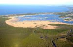
Ecosystems in Kemeri National Park:
- Forests - 57 %
- Wetlands - 24 %
- Meadows, although covering only 6 %
- Waters cover 10 %
- Dunes are found both along the coast of the Gulf of Riga and in inland areas
Cultural features The areas of the richest cultural heritage in KNP are Lapmežciems municipality and Ķemeri - a town of national importance due to its architectural monuments (Hotel “Ķemeri”, a water tower, a Lutheran church and Ķemeri Park with its architecture etc.) Many valuable cultural monuments were destroyed during the two world wars. Some of them were destroyed during the Soviet times.
Ķemeri is long famous for its curing springs. The first water analysis was done in 1801 by an academic from St. Petersburg, T. Lovics. In 1891, the first data was published about using mud for medical purposes.
Most significant objects to see in Ķemeri:
- Ķemeri Railway station
- Hotel “Ķemeri”
- Water Tower
- Ķemeri Park
- “Love Islet” and Pavilion – Rotunda
- Restaurant “Jautrais ods” (‘Cheerful Mosquito'), now called “Meža māja” (“Forest House”)
- Catholic and Lutheran churches
- Orthodox Church of St. Peter-Paul
- Ķemeri Bathing Facility
- Sulphur Spring Pavilion “Ķirzaciņa” (“The Lizard”)
Ķemeri National Park includes also some old fishing villages along the coast - Bigauņciems, Lapmežciems and Ragaciems.
There are two archaeological monuments of national importance in the Lapmežciems municipality:
- Siliņupe Stone Age settlement
- Kaņieris Castle mound
Cultural/social/political context
Activities of KNP are to regulate laws and regulations. The administration of KNP is under the Ministry of the Environment.
Framework of administration:
- department of supervisory;
- department of research;
- department of management;
- department of nature education and tourism;
- department of financial.
Financing of KNP is by national budget and own proceeds.
KNP takes part in international projects and organizes activities and seminars (e.g. The days of birds, The nights of bats).
History
The history of Renaturalization of the Slampe River
-
 Slampe River site in a Kemeri national park map.
 -
 Renaturalization of the Slampe River by digging meanders and thus imitating the former floodplain situation


During the Soviet times (1960-70), meadows surrounded by forests were cleared of the shrubs, and the Slampe River was straightened by cutting a deep channel through the floodplain, thus making the formerly wet meadows and the landscape rather monotonous.
- 2000-2004 buying out private lands
- Until the end of 2004 output and coordination of technical project
- The summer of 2005 the object was put into operation (within a frame of the EU LIFE-Nature project)
The result
- The river was restored in its originally weaving shape by digging meanders and thus imitating the former floodplain situation.
- Already few years after digging works the riverbed host many water plants and animals providing habitats which are more diverse than those of the previously straightened river.
Spatial analysis of area/project/plan
Site accounts:
-
 National location
 -
 Habitats, Land cover


Critical decision:
- Owing to the current economic situation the rural landscapes, especially those around big cities (Rīga and Jūrmala) are threatened by natural succession, explansion of building areas, intensive forest logging(particularly in private forests). As a result the expressive forest clumps, in the rural landscape are replaced by bushes. Observing the landscape protection requiments in spatial planning and close cooperation with the landowners and municipalities are offered as the main solution to raise public awareness and enable some action for landscape protection.
- The degradation of landscapes
- The mosaic structure of landscapes. It is important for the preservation of human emotional perceptions, psychological well-being and the satisfaction of aesthetic needs, and for the maintenance of biodiversity in the area.
-
 Spatial landscape structure
 -
 Functional Zones


 Urbanized territory
 Bog territory
 Forest territory
Functional Zones
According to the Law on Kemeri NP, in the territory of National Park the following functional zones are established:
- Nature reserve zone
- Nature protection zone
- Landscape protection zone
- Neutral zone
- The nature reserve zone(red color) has been created to preserve territories intact by human activities and little transformed territories. In these territories undisturbed development of natural processes is provided and rare or typical ecosystems that are important for providing the ecological needs of rare und migratory species are protected.
- Nature protection zone(green color) has been created to protect the ecosystems with low disturbance level of human activities, the sites of rare and endangered species and the types of rare habitats, as well as developed peat pits and the processes of origination of mineral waters.
- The landscape protection zone(yellow color) has been created to preserve the resourses of tourism, relaxation and education and the origination process of mineral waters; to preserve the nature, cultural landscapes and to reduse antropogenic influence on the nature reserve zone and protection zone.
- The neutral zone (gray color)has been created to encourage the development of heath resorts, to preserve the landscape and the archetecture characteristic for the region and to encourage sustainable development of the territory of the national park.
Analysis of program/function
- What are the main functional characteristics?
- How have they been expressed or incorporated?
Functional Zones
According to the Law on Kemeri NP, in the territory of National Park the following functional zones are established:
- Nature reserve zone
- Nature protection zone
- Landscape protection zone
- Neutral zone
Analysis of design/planning process
- How was the area/project/plan formulated and implemented?
- Were there any important consultations/collaborations?
Illustration: Map/diagram/sketches photos and background notes
Analysis of use/users
- How is the area/project/plan used and by whom?
- Is the use changing? Are there any issues?
The use of natural resources:
- Forests management
- Hunting, angling, fishing
- Water supply
- Medical mud and mineral extraction
- Dolomite, gravel and sand extraction
- Peat extraction
- Pollution objects
- Reed extraction
- Agriculture
Use of seashore
- Fishery, the involving actions
- Building/construction
- Activities of holiday-marers and tourists
- Cultural history
How is the area used?
- Municipalities
- Landrowners
- Mass media
- Local residents
- Schools
- Visitors of the park
Cross-cutting questions
Why is participation important?
- To provide interesting, professional activities (In collaboration with the Latvian Ornithological Society each year are organized Avian days in April and the International day of bird-watching events "Kemeru feathers" at the beginning of October.
- To involve the community, schools (in collaboration with the Kemeru National Park Foundation for the third year there are long-term cooperation program "Tracks live!" (Slampes River monitoring of the public)
- To landscape the site (KNP administration, the Ministry of the Environment and the "Cemex" has signed a protocol to support bird-watching tower construction and infrastructure in KNP area.)
In which ways does tourism effect on the local identity?
- Within this area, tourism is not so intense, to affect negatively to the identity. That highlights the value of nature, allowing the public to see and understand it (nature trails, animal observation). Identity is influenced more by new housing areas (e.g. the sea coast).
- In international project "Park and benefit" the main emphasis of the administration is placed on sustainable tourism development in cooperation with the park area and the surrounding businesses, residents and municipalities.
Which are the mutual influences for protected areas and cultural landscapes and tourism and how can they coexist?
- KNP represents management model that will help preserve the natural values for future generations, while allowing the greatest possible benefit to people living and working in its vicinity.
- Natural values are gradually becoming an important factor conducive to economic development in their region
- There was large impact on natural areas during the last construction boom, since the park's administration experienced tremendous pressure from the private owners to make new building plots in the park area, hence increasing the building intensity and population. Land owners are still dissatisfied, and seek to create new pieces of the building trade.
What are the tasks of the management?
- Control and manage the national park areas in accordance with the law of Kemeru National Park, Kemeru park protection and use, the conservation plan and other laws and regulations
- Inform and educate the public, particularly local people and school youth, in ecology and nature conservation;
- Provide development of conservation planning
- Promote sustainable economic activities and nature-friendly tourism development
Future development directions
- How is the area/project/plan evolving?
- Are there any future goals?
Illustration: Map/diagram/sketches photos and background notes
Future goals Landscape development goal: Preservation of open farmland to save landscape diversity at Kemeru NP taritory.
Landscape near the roads: Create a diverse and safety-enhancing landscape. It is important to be visible from the road actually site-specific landscape, rather than isolated from the surrounding road corridor.
Working with the community: Using the mass media and encouraging public participation, strengthening of Kemeri national park public's mind as the public interest in areas with unique natural and cultural and historical values, which is favorable and confirms the originality of the park's context
• Kemeri national park - recognizable, popularized in the available information on the park's natural and cultural values; • Kemeri national park regularly updated booklet range park is also issued to the newspaper; • Information about the park can easily be found on its web site; • Regular meetings of the population, various cooperative projects with interested organizations; • The park has its own information center, as well as exposure on both the nature and cultural history; • As a result of cooperation between the park visiting various tour groups from the tourism firms, participating in park tourism fairs; • National Park establish its own traditions and hosting the annual event, the general public
Peer reviews or critique
- Has the area/ project/plan been reviewed by academic or professional reviewers?
- What were their main evaluations?
Pleas add references, quotes...
The Slampe river reconstruction project are not been reviewed by academic reviewers.
Points of success and limitations
- What do you see as the main points of success and limitations of the area/project/plan?
Illustration: Summary table
Slampe river reconstruction project
few years after digging works the riverbed host many water plants and animals providing habitats which are more diverse than those of the previously straightened river. In the course of time the re-naturalized stream start to create new habitats – small-scale erosion banks and deposits of sediments providing a variety of suitable dwelling and feeding sites for numerous water creatures
Bog restoration
Already in the first years after restoration, the newly created wetland with shallow water offer suitable habitats for several bird species such as sandpiper, lapwing and redshank. Also cranes and swans can be seen here. Within the last years significant changes in vegetation were observed. The flooded trees and shrubs are dying out, thus forming more open landscape. On the rewetted peat fields the monotonous heather is drying out and gradually being replaced by species, which are typical for depressions in natural raised bogs - beak sedges and cotton sedges
Meadow management
several years the administration of the national park is managing the meadows, thus preserving not only the landscape-level diversity, but also ensuring existence of many plant and animal species. In 2009, the total area of managed meadow area will comprise around 600 ha. The meadows are mowed and pastured every year. In floodplains along the Slampe and Lielupe Rivers free-ranging Heck cattle and Konik horses had been introduced. In some areas the abandoned meadows were cleared from shrubs and regular mowing was established. In order to observe the changes caused by management, a regular monitoring was established. As a result of successful management, the observations over the last years show positive changes toward more diverse grasslands providing suitable habitats for many plant and bird species [www.kemeri.gov.lv]
What can be generalized from this case study?
- Are there any important theoretical insights?
Short statement plus background notes
Eny landscape has own way how to manage and develop tourism infrastructure, and how to protect the unique landscapes in the people living location.
Which research questions does it generate?
Short statement plus background notes
Image Gallery
-

-
 Ķemeri National Park offers its visitors possibilities to watch birds, herbivores, beavers and bats.
 -

-
-

-

-
 pictures: www.kemeri.gov.lv


References
Please add literature, documentations and weblinks
About categories: You can add more categories with this tag: "", add your categories
Kemeri National park: [[1]]