Landscape Democracy 2015 Working Group G - Case Study 5
---> back to group page working group D
Please add the title of your case study here, adjust the map coordinates (lat + lng) and replace the moa image with a characteristic image of your site
| Place name | Kuril Flyover | |||||||||||
| Location | Dhaka | |||||||||||
| Country | Bangladesh | |||||||||||
| Author(s) | A S M Muttasif Hasan Dip | |||||||||||

| ||||||||||||
| {{#widget:GoogleMaps | width=300 | height=200 | lat=23.8206955 | lng=90.418666 | zoom=15 | centermarker=yes | maptypecontrol=yes | overviewmapcontrol=yes | largemapcontrol=yes | scalecontrol=yes
}} | ||
Rationale: Why have you chosen this case for the landscape and democracy seminar?
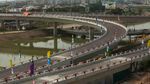
Kuril flyover is an important infrastructure in modern-day Dhaka; which was completed in the mid of 2013. It attributes some major circulations; with a helix-like network. Dhaka is poorly known for it's Traffic jam and according to this reality; the Flyovers was really a blessings. It is close to the Shahjalal International Airport; so along with the necessity the Government wanted to build this modern, beautiful and expensive infra-structure to uphold the New Bangladesh Brand.
But, the problem is somewhere else; like many other mega-projects of Bangladesh; this one was not multidisciplinary enough. So, when it facilitated the automobiles by ensuring thoroughfare; none was thoughtful about the Humane things. People and their supporting activities were terribly ignored, whereas, there are options and spaces, there are kinds of latent opportunities!
Representation of your observations
- you are basically free to use one or a mix of different presentation techniques
- possibilities are: analytical drawings, graphical representations, collages, video clips, comic/graphic novel, written essay/visual essay
- please add any visual material to the gallery, videos can be placed below, you may add text as you like
https://www.youtube.com/watch?v=exXSaJ6tuV0
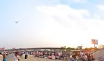
1. The smooth transportation is interrupted, people crossing over, lack of foot over-bridges. 2. A successful project in City-scale; but hostile for the surrounding residents. 3. No uninterrupted pedestrian 4. No thoughts given on the Universal access for differently abled people. 5. A huge negative landscape(water body) beneath the fly-overs. 6. No pedestrians for passers by. 7. Where there are pedestrians, no activities. 8. Poorly maintained SHADOW areas. 9. Thrust of Public-activities;bdangerously just beside the Roads. 10. Landscaping with no use. 11. Water-body with no edge-treatment and with no water-purifying.
- Observations
-
 case representation
 -
 case representation
 -
 case representation
 -
 case representation


Reflection
What are the major challenges for changing the situation?
The flyovers are really in a great use now-a days; facilitating thousands of automobiles and almost lessened the traffic jam around. The situation in the Shadow area is still not properly noticed. Even the city-people don't have the consciousness. They don't believe in asking for anything from the Government. So, the major challenge is to make them awake. The awakening can be started by the Media, Activists and the Experts (but still Media has to understand the issue as an important one; as in Bangladesh not even Media usually bother about this type of social problem).
And after that, the Government and it's bureaucracy. Government; in a developing country hardly care for People's voice/need. In a semi-capitalist manner; more than a HUMAN, they are more respectful to a HUMAN with MONEY. So, the general practice there is to way-out the cars; and try to survive if you are a general Passers-by walking on your foot.
So, the biggest challenge is not only the developing the place; rather to make them (authority and the users) realize the duty, priority and culture. Only then the later acts can be initiated.
What could be a starting point for democractically-based change?
The starting point to change the scenario is obviously an inclusive movement. As Bangladesh is still a 'democratic' country; people has the right to speak-up. The Government doesn't usually care as they take decisions always in a top-down manner; but still if the users are concerned and raise their voice; it can change the perspective. In this case, the voice can be stronger if Media (digital, print, social), activists (NGOs, Environment organizations) and experts (Professors, Planners, Architects, Engineers) can speak-out on the same point.
The expressways has cut-down the communication between two surrounding areas indecently; and still there is an untreated water-body and open space in between; whereas the residents in adjacent areas don't actually have any defined public space. Though primarily it is a matter of a bit hegemony; still the users have the right over there.
They should be given the safest pedestrians and crossing, the proper access-way for the differently abled people. And of-course all the changes and decisions should be discussed, reviewed and more importantly participated by the users. They should be having the sense of owning the area; which will be the important factor to protect/maintain after the completion. Ensuring the access and rights over the place, can be the starting point for Change!
Stakeholder Mapping
Create a visual representation of the stakeholder groups that are involved in your case. Try to cover the following aspects in your representation: Power (high, medium, low) / Support (positive, neutral, negative)/ Influence (high or low)/ Need (strong, medium, weak)+ also map the relationships between the stakeholder groups
- Stakeholder Map
-
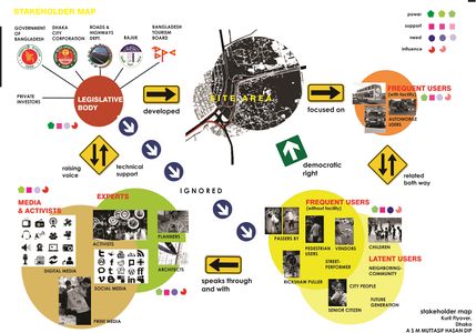 Stakeholder Map

Change Scenario
Look at the various methods and tools available and think how they can be applied creatively. Think about the needs of different stakeholder groups - you may need a methodical mix to address them all. Visualize a scenario illustrating how these methods/tools can be applied within an imagined time frame
- Change Scenario
-
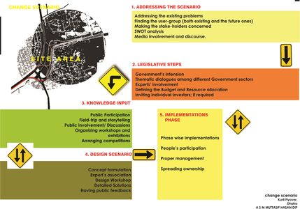 Change Scenario

Cross cutting theme
Identify a cross-cutting theme/topic between the cases of your group and write a short reflection on it (approx. 150 words)
During the Assignment, all of our group members had the opportunity to analyze/ go through others situations. Moreover we had the same problem in less democracy in constructing infrastructures and absence of participatory development. In all our cases; irrespective of the Geographic location and different stakeholders; we found the necessity of Public awareness and Participation, Enrollment of proper Experts, Media's influence, Government's intention and most importantly a back and forth process while designing for and along with the Community.
As an understanding phase, we had to observe it more holistically; as the Detailed decisions are yet to be taken under necessary circumstances and will be depending on evaluating more Data. Still, we were able to find out the common situations; like public voices are not being count. So, all of us tried to know about the stakeholders (their needs, power, necessity and influence), to address the Participatory approach of designing, to involve the Government/Authority in a Sensitive and Monitory role and the proper management after the completion by harmonizing the system with the users for a long-term/ continuous Timeline.
Concluding reflections
Reflect on your case and your change model. Potentials? Limitations? (approx. 150 words)
In my situation; I had to be a little hypothetical as Bangladesh has no real practice of counting the Bottom-up decisions. So, to raise the awareness is the prior challenge and the primary limitation as well. On the other hand, Media; in Bangladesh have become enormously strong now-a days. So, the Experts/ Activists on behalf of the community can reach the Government through the media and Vice-versa. The place has the potential and the community also has the latent urge of dynamic usage. All what is needed to awaken all about the rights and duties.
Experts should design the Environment through a Participatory design process; need to have regular feedback from different users representing the Community. They should arrange some Idea invitation for the users as well. Nevertheless the Authority and the Experts should try to make the people understand that, the place; it's maintenance, beauty and purpose is all up to the users, to gain a proper implementation and an efficient management.
References
* Please make sure that you give proper references of all external resources used.
* Do not use images of which you do not hold the copyright.
* Please add internet links to other resources if necessary.
http://bd.geoview.info/plan_and_layout_of_kuril_flyover_intersection,35048929p http://www.dhakatribune.com/development/2013/aug/03/pm-open-kuril-flyover-sunday https://www.google.com.bd/maps/place/Kuril+Flyover,+Dhaka/@23.8203937,90.4181054,17z/data=!3m1!4b1!4m2!3m1!1s0x3755c65053c60705:0xddf4c04e306fb5da http://cp.bangladeshinfo.com/headline/kuril-flyover-opens-today/ https://www.youtube.com/watch?v=exXSaJ6tuV0
About categories: You can add more categories with this tag: "", add your categories