Landscape Democracy 2015 Working Group G - Case Study 1
---> back to group page working group G
Eskişehir Boulevard, Ankara, Turkey
| Place name | Eskişehir Boulevard | |||||||||||
| Location | Ankara | |||||||||||
| Country | Turkey | |||||||||||
| Author(s) | Bircan Gizem Gürakar | |||||||||||

| ||||||||||||
| {{#widget:GoogleMaps | width=300 | height=200 | lat=39.907701 | lng=32.764776 | zoom=8 | centermarker=yes | maptypecontrol=yes | overviewmapcontrol=yes | largemapcontrol=yes | scalecontrol=yes
}} | ||
Rationale: Why have you chosen this case for the landscape and democracy seminar?
Eskişehir Boulevard is one of the largest and most frequently used boulevard in Ankara, the capital city of Turkey. Via this axis, the west and the east neighborhoods of the city are connected, thus it connects Ankara to Eskişehir, the nearest city located on the west side of Ankara. The boulevard takes its name from connection between Eskişehir and Ankara, therefore the traffic is generally the heaviest among other boulevards in the city. Despite of this heavy traffic, Ankara is growing throughout the sides of Eskişehir Boulevard. Most of government offices began to be moved all along the boulevard one by one; private offices, residences and shopping centers began to be built on the street, and three most biggest university campuses in Ankara are already located on it before those changes. As consequences, at most parts of boulevard, pedestrian ways are not available to use (at some parts it gets narrower, at some parts it dissapears) because of the heavy traffic, pedestrians are only allowed to cross through the street by pedestrian bridges (without any elevators) placed in insufficient amount. This boulevard is perceived by inhabitants as an unpassable border, which creates a functional division in the city. In this point, it is impossible to say that the environment along the boulevard is created, or at least influenced, by choices or wishes of community, except for the landowners, project helders and the municipality.
Representation of your observations
- Observations
-
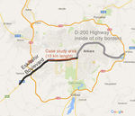 Image 1: Location of Eskişehir Boulevard
 -
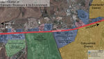 Image 2: Land Use Analysis
 -
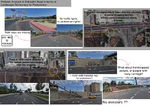 Image 3: Problem Analysis of Eskişehir Boulevard in terms of Landscape Democracy for Pedestrians.1
 -
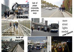 Image 4: Problem Analysis of Eskişehir Boulevard in terms of Landscape Democracy for Pedestrians.2


Reflection
What are the major challenges for changing the situation?
It would be not so easy to apply certain changes to Eskişehir Road as many decisions-as they are not considered in many aspects- are applied before thinking about democratical use of the space. There would be seen many challenges, but I handle those challenges in two aspects: The first one, re-regulation of traffic way and public transportation would be the first challenge on that part of Eskişehir Road that I consider as my case area. Most of ministry complexes are moved onto the case area. Because the officers working at those municipalities generally prefer shuttles only served to officers, the rest of them mostly prefer their private cars (Tekin, 2008. pg:53-54). This creates an enormous traffic jam in mornings and evenings especially, as the road is mostly used by west-side inhabitants to reach to work places locating in city center and to turn back to home. When some other reasons of traffic jam are considered together -location of commercial centers, neighborhoods, two frequently used shopping malls and three university campuses locating on both sides of the road-, the problem is getting more complicated. Secondly, lands privatized by the government have not been divided into plots taking pedestrian priority and rights into consider. Reserving only 1.5 meter width for pedestrian way on a 40-meter width boulevard is not reasonable, since the boulevard is frequently used. It is not safe, functional for anybody, or not a place that its users have a voice on that place (Tekin, 2008. pg: 58).
What could be a starting point for democractically-based change?
These problems could be solved in many ways. Since our topic is democracy and landscape, it would be better to deal with these problems including public's decisions. According to Renn et al. (1993), a model is needed that combines technical expertise and rational decision making with public values and preferences. In their conceptual model for participatory decision making, three types of knowledge is essential. These are represented by stakeholders for the identification of concerns and objectives, technical experts for measurement of investigations and citizens for evaluation of options in citizen panels. This model could be applied in my case study, "Pedestrianization of Eskişehir Boulevard" if it could be adapted to the context. Adapting this model to the context may be the hardest step. As an example, stakeholder groups defined by Renn et a. (1993) are "socially organized groups that are or perceive themselves as being affected by the decision". These groups could be adapted as pedestrians, drivers, planners and administrators in bold outline. Problems should be defined and discussed by those institutions with the help of questionnaires, panels, or workshops.
Stakeholder Mapping
- Stakeholder Analyses for the Project 'Non-Motorized Mobilization in Eskişehir Boulevard, Ankara'
-
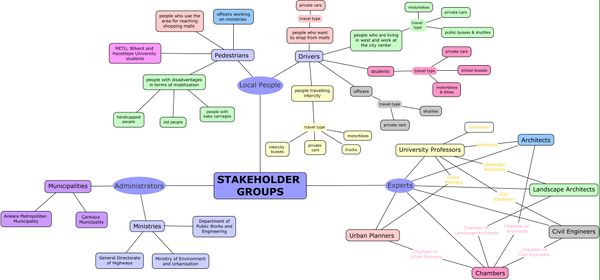 Image 5: Stakeholder groups on decision making of Eskişehir Boulevard pedestrianization process
 -
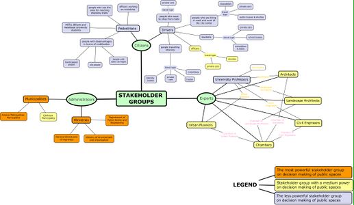 Image 6: The power relation between stakeholder groups on decision making of Eskişehir Boulevard pedestrianization process
 -
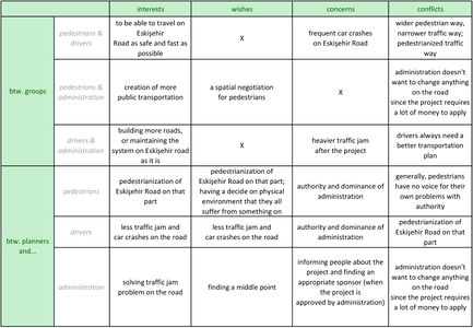 Image 7: The power relation between stakeholder groups on decision making of Eskişehir Boulevard pedestrianization process
 -
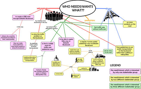 Image 8: The needs/wishes/interests of stakeholder groups on decision making of Eskişehir Boulevard pedestrianization process and the power relation between those needs/wishes/interests


Change Scenario
- Change Scenario
-
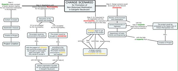 Image 9: Change Scenario for Promotion of Non-Motorized Mobilization in Eskişehir Boulevard: Step-by-step Analysis
 -
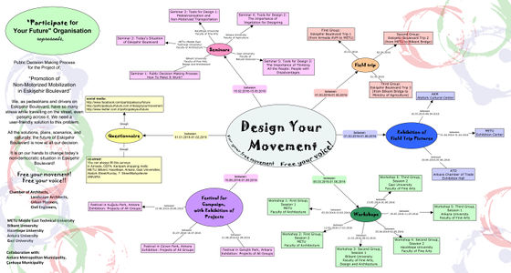 Image 10: A posterized scenario sample explaining public decision making process for changing Eskişehir Boulevard


Cross cutting theme
Between Stakeholder Groups: The relation of citizens/public, experts/professionals and administrators/leaders between main stakeholder groups; then it begins to differ from area to area.
Between Our Scenarios: The general system of our interventions to the projects: Some of us develop more specified(Ziou and Gizem) and the others(Muttasif, Jorge, Elena) work on a more holistic ideas on the common intervention system.
In conclusion; even though we want to work with different methods for promoting public participation in our case studies, we all try to say generally:
«start with experts and administrators --> continue with public --> develop ideas with public --> make it happen with experts and administrators»
Concluding reflections
Reflect on your case and your change model. Potentials? Limitations? (approx. 150 words)
References
[Untitled Image of Night View of the Boulevard]. Retrieved November 29, 2015 from http://pbs.twimg.com/media/BDKXkF4CIAAaqTk.jpg
[Untitled Image of Eskişehir Boulevard]. Retrieved November 29, 2015 from http://pbs.twimg.com/media/BGLrFY_CIAEjUBa.jpg
Aral, E. & Demirbaş, Ö.O. (2015). Pedestrians' Perception of Sub-Spaces along Urban Roads as Public Spaces - Case of Eskişehir Road in Ankara. METU Journal of the Faculty of Architecture, 32:1, 45-64. Retrieved from http://jfa.arch.metu.edu.tr/archive/0258-5316/2015/cilt32/sayi_1/45-64.pdf
Eskişehir Yolu, Armada Darboğazı’na Kolay Çözüm[Online Image]. (2014). Retrieved November 29, 2015 from http://www.blogankara.com/eskisehir-yolu-armada-darbogazina-kolay-cozum/
Renn, O., Webler, T., Rakel, H., Dienel, P., & Johnson, B. (1993). Public Participation In Decision Making: A Three-step Procedure. Policy Sciences, 26(3), 189-214. Retrieved from http://elib.uni-stuttgart.de/opus/volltexte/2010/5300/pdf/ren17.pdf
Tekeci, F. (2014). Eskişehir Yolu’nda Kelle Koltukta[Online Image]. (2014). Retrieved November 29, 2015 from http://www.ankaraburda.com/Hbr-1661-Eskisehir-Yolunda-kelle-koltukta-tr.html
Tekin, T. (2008). Transformation of an Urban "Vector": Eskişehir Highway, Ankara (Master's thesis, the Graduate School of Natural and Applied Sciences, Middle East Technical University, Ankara, Turkey). Retrieved from http://etd.lib.metu.edu.tr/upload/12610011/index.pdf
About categories: You can add more categories with this tag: "", add your categories