Hangzhou
weave a new memory for Westlake (Hangzhou, China)
| Name | Comprehensive protection project of Westlake | |
| Place | Hangzhou | |
| Country | China | |
| Topic | Water, human and City | |
| Author(s) | Chinyi Gu | |
| Completion | 2006 | |
| Client | Government of Hangzhou City | |
| Project costs | (5,000,000,000 RMB) | |

| ||
| <googlemap version="0.9" lat="30.264405" lon="120.231628" zoom="11" width="300" height="250">
</googlemap> | ||
Rationale: Why is this case study interesting?
It has never been such a story and would never be such a story which could clarify the relationship between human, city, life and nature more expressively in Chinese history. The story is deposited by struggles, hardship, repetitions, as well as joy, triumph and harmony.
Westlake, located in center of the city Hangzhou, boasts one of the most prominent scenic spots in China. The coexistence of the city and the lake has gone through more than thousand years. The lake is surrounded by mountains from three sides and face with the dense urban construction on eastside. In this senses, westlake and the adjacent mountain played a critical role in prevent the sprawl and actually become the last oasis without being perished.
In 2002, the third time of dredging and comprehensive protection project of Westlake. Hangzhou China, was initialized. Superficially, it was only one of thousands dredging projects in the history of Westlake. However, considering the pretermission during the last 300 years, the quality of lake existence, the symbiotic relationship between human and lake had deteriorated into a severe condition, this project carried more commissions both ecologically, culturally and pragmatically. Meanwhile, this project connected the grand cannel, Qiantang river,to the Westlake, which enable an extensive water flowing and subsequently boost the self cleaning capacity of the natural water body in this area.

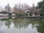
Panorama of West lake
Author's perspective
- What theoretical or professional perspective do you bring to the case study?
As a master student in the joint course 'Landscape architecture',I initiated the first semester with the case study. With biologically academic background,the only experience I obtained in landscape architecture was the working period in Shanghai, China. The case study here I engaged myself in is the comprehensive project West lake, Hangzhou, purely due to its great hitorical significance, magnificient scale and the humanism behide the design. Although limitation and drawbacks could be found to a large extent in this project compared to the counterparts in Europe and US, especially the approach dealing with ecological issues,it also claims to be a sample which made a progress in the area of chinese landscape design. As one part of the Seminar,I wish this section can be a reference resource for people who want to know the landscape planning and protection in China.
Landscape and/or urban context
- Biogeography, cultural features, overall character, history and dynamics
Generally Introduction
West lake is located in the very center of Hangzhou city,the capital city of Zhejiang province, which boasts the most prosperous region in southeast of china. North to Westlake situated Qiantang riverwhich is the origin of Westlake. Qiantang river flows into the East China Sea through Hangzhou Bay. it is also the southern terminal of the ancient Grand Canal. The whole area of Westlake covers 6.38km2, Annual run-off is around 14,000,000m3 while freuquncy of water substitution is once per year.
The geographical evolution of Westlake
Trace back to the origin and history of West lake, the whole span of the lake falls into two phases with the former one attribute to no more than a natural evolution of a lake——from a bay nearby the Yangzi delta, to a lagoon and finally enclosed by alluvial clay from Qiantang river. This is approximately the phenotype of the Westlake we are familiar with. However, if evolution was straightly going through, the lake should have been swallowed by the sands and sendiment from streams which connect Qiantang river and Westlake, then finally be converted into farm land or swamp.
However, the settlement of inhabitants in this area absolutely changed the fate of Westlake, as a result unravel the second phase of Westlake——from a natural lake to an artificial lake that is protected by dam and dredged consistently. Due to the need of drinking water for the increasing population, whereas all the water from river, even from the wells deeply digged in this region are all contaminated with the salty water from east China sea, the residents had to rely on the precious eligible water from Westlake. The coexistence relationship was reinforced with the establishment of Hangzhou as a capital city of China in Song dynasty.The political decision obviously place westlake in a more significant status and therefore, the revitalisation of westlake became the rountine exploit of each dynasty and each emperor either in aesthetical way or ecological way.
-
 overview of Westlake (image extract from google earth)
 -
 The evolution of Westlake
 -
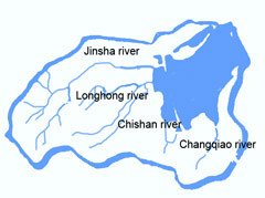 The main runoffs of Westlake


Status before compeletion of protection project
Landscape features
Westlake is divided by Gu Shan, Bai, Su Causeways into five areas. They are outer lake,Inner lake, north inner Lake,south lake and Yue Lake ordered by areas. Three man-made islands, "Xiao Ying Zhou", "Hu Xing Ting", "Ruan Gong Dun" lie in the center of outer west Lake, which is also accordfully follow the tradition "one lake three islands". Thus formed the famous layout of Westlake "one hill, two causeways, three islands, and five lakes". "Ten Scenes of the West Lake", the legendarly collection of ten scenic views formed during the Southern Song Dynasty and are distributed around and within the lake, They have their names inscribed in the list of most prominent scenary spots in China.
- Leifeng Pagoda in the Sunset
- Fish Viewing at the Flower Pond
- Orioles Singing in the Willows
- Three Ponds Mirroring the Moon
- Lotus Pool in Summer
- Twin peaks piercing the clouds
- Spring dawn in Su Causeway
- Late night bell at the Nanping Hill
- Autumn moon on calm lake
Hydrology Except for rain water, the compensation of Westlake was mainly generated from four natural runoffs:(from north to south) Jinshan river, Longhong river, Chishan river, and Changqiao river. The rapid industrialization and economics development since 1978 in China was in some sense obtained at the cost of the loss of ecological balance. Westlake was unexceptionally suffering from a severe pollution derived from industrial manufacture outlet, trash abandoned by tourists, along the watefron. In order to attain a relative clean waterbody, Qiantang River was connected to Westlake during the second Westlake protection project (1985 AD) by around 2800 transportation tunnel. The water sucked from Qiantang river was split into two parts, one of which injected into inner lake, while the other pour into outer river. In 1987, to match the new inflow from Qiantang river on south side, Shentang sluice was reconstructed to enhance the outlow on north side.
Ecosystem:
- Forest ecosystem
- Freshwater ecosystem
- Wetland ecosystem
Freshwater and Wetland ecosystem were severely perished because of the eutrophication, overgrow of phycophyta and sediment intrusion, which obsessively damaged the health of Westlake since the beginning of its formation.
Administration The prominent "Ten scenic sopts of Westlake" attracted millions of tourists each year.The profit came from fee charged from tourists were always a significant income for government, To raise money in this sense, the whole region of Westlake (waterfront) was divided into several pieces mainly in terms of scenic spots, which was isolated from each other by fences, walls. This sort of small pieces of waterfront area were made to be like the so called "Park" (Orioles Singing in the Willows Park, Gerontic Park, Juvenile Park and Long Bridge Park for example)after all and were ruled by organizations independently.Ticket was also charged independently to everybody except for certain group of users (elders and youth).
Cultural/social/political context
Cultural Context The cultural history of Westlake has been described in detail by countless of books, both national wide and international wide. Obviously Westlake is a attractive place full of legends and stories which even appeal to people nowadays and inspire the passion of art work creating from artist, poet. A brief introduction of Westlake history can be seen in the subpage West lake in Wikipedia
However, Su causeway and Bai causeway, the masterpieces owe to the exploit from Su Shi and Bai Juyi, both of who were the top artists and officials as well at their own time, is particularly worth mentioning here to elicit their talents, this creatively merged the aesthetic feature into hydrological feature.
Political context of the comprehensive project of Westlake
In spite of the governmentally organized measures taken since 1949, which include routine dredging by employing ferry boat, channeling various water source to purify the water quality, issued regulation to impose the legal obligation on individual and firms, which attempt to avoid the pollution caused by unscrupulous dumping of trash, the quality of the water of Westlake did not improve a lot due to the loose administration, natural eutrophication process of Westlake.
In 1990s, the plan of Comprehensive protection project of Westlake was conceived mainly because Westlake, one of the famous cultural and social heritage of China, started the procedure to apply for the world natural and cultural heritage site.
History
- How did the area/project/plan at the focus of the case study evolve?
The history of West lake is bond to the history of the Hangzhou city. Here we can easily, swiftly find out numerous websites (mainly tourism websites)describing Westlake together with the Hangzhou city. To save my clumsy endeavor here, I list several links, which had submitted a wonderful description for history of West lake.
Spatial analysis of area/project/plan

- What are the main structural features?
- How has it been shaped? Were there any critical decisions?
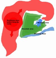
Morphologically,the whole project is roughtly divided into two parts, with the red part illustrated in the image concerns the west part of lake, which has disappeared before ca 400 years, and the blue wide part, which has always been hot scenic spot visited by millions of people each year. The project intended to resume the red part (Westside progression) and renovate the waterfront of all along the lake. Additionally,certain measure was also taken to speed the circulation of water in order to improve water quality.
Core Questions Working Group Nature Conservation / Water
What is the role of user groups?
Hangzhou is usually regard as the “shanshui" city( the city located in a landscape with moutain and river), which indicates a large amount of nature heritage resource. The user groups actually include all kinds of people living in the city and also, people pass by to follow the trace of stories and legacy accumulated in the long histroy of Westlake. Recreational purposes account for the main reason for the people come from the other place while for local residents, Westlake is actually worked as a "background" engaged in all sorts of activities people participated in.
What is the role of the city?
The coexistence of city and lake is pretty striking in this case. Initially, the lake served as a functional element(drinking water for residents to sustain their life) for the city, and with its development, the lake is no longer used as a source of drinking water.The lake, with the mountain beside the lake, are enclosed by the urban space and actually doomed to be dependend on and in accordance with the development of the city. In this sense, the city, or, lets say, the city composed of various combination of people live in the city,plays a leading role in the "lake-city" relationship.
How do urban and natural structures interact?
Westlake is surrounded by mountain from three sides. To this point, only one side was left to attach the border of "urban" structure. The east border of west lake remians a tough problem for all the designers to cope with.The natural shore from the other three sides, which dotted with numerous amazing senic spot and fauna shed with beatufifully shaped peaks, dimmed the concrete forest along the east side. The skyscrapers, build up were just one lane away from east side of Westlake without any shield.This problem remains unsettled during this project,however,we anticipate in the next 10 years,municiple government of Hangzhou can take measure to prevent the city sprawling by either demolish certain existed buildings or draft relative regulation to control the building of highrises.

What is the role of water?
Compared to the city, which is the leading domain in the 'coexistence' relationship. the water is changed by the activities of human being. Nowadays, the role of the lake is purely for recreation, which boasts as the most famous scenery spot in China. It is because of the significance of the culture heritage it carries that make the existence of the lake more prominent than ecological means.
What is the evolution of the urban relation between humans and nature?
The first span of Westlake is non-artifical, which was kept until people started to settle down in the lake region, the humid place with salty land, which supposed to be unsuitable to live on. During the second span of Westlake, the "human" plays a leading role in deciding the fate of Westlake, mainly due to the need of edible water to satisfy the daily use of local inhabitants at first, and then gradually developed fish breeding to feed the exploded population, the dredging act is never ended. The aesthetic function of Westlake was firstly established in Tang dynasty, and outreached the other functions in Song dynasty, while Hangzhou (Lin An) was chosen to be the capital of Nansong. Served as a backup recreational site, The popularity of Westlake as a scenic spot had been won not only among the royal members, but also scholars, bureaucrats, poets, painters and even normal people. The artificial influence released by human being was reached its zenith and never be changed again in the next thousands of years.
The chronicle of dredging project in the chinese history
Year Dynasty Measure 766-779 Tang Six wells were digged to channel the water from westlake to the inner city in order to offer the edible water to the inhabitants in Hangzhou
around 822 Tang A dam was builded to protect westlake from invading, the water from westlake started to be used in irrigation, which is crucial to the farming in this area
around 907 WuDai (five dynasties period) Strengthen the Dreding up to prevent the stagnation, Yong Jin pond was channeled to connect the Westlake and Grand canal
1007 Song revitalation project
1021 Song Fishing was forbidden to protect the stability of the ecological system
1060 Song South Well was digged to supplement the eligible water source for inhabitants
1089 Song Dredging project, the removed soil was reused to build a causeway all across the river, and was named after the project leader, the famous accomplished politician, artist, poet, Su shi (Su causeway). Three stone pergodas were also established in the center of the lake to mark the boundary of fishing forbidden region. This revitalation project was claimed as the most succeesful project in the history and therefore build a example for the following steps for its triumph on both ecological and aesthetic aspects.
1165-1173 South Song rebuild the "Six wells"
1247 South Song remove the water plants (Lotus),which stagnated the water exchange between lake and other channels
1456 Ming two flood gates were build to control the water level
Ming transportation system was established to ease the process of dredging
1505-1508 Ming demolish around 1000qm farming land to broaden the lake, the soil was reused to reinfoce Su causeway,besides, a new causeway was build and again named after the project leader, Yang Minyin( Yang causeway).
1607 Ming dredge the river and a dam was builded inside the river (the scenic spot lake inside lake was then established)
1809 Qin Dreding, island "ruangongdun" was built
1864-1876 Qin Dreding buro was established,which was in charge of the annual dredging
-
 Please add subtitle here
 -
 Please add subtitle here


In the very begining when people and the nature(Westlake and the adjacent mountain area) start to contact, they are limited to their own circle, the city is not close to the lake. After Song dynasty, the interaction became strong due to the demand of edible water for booming city development. Afterwards, with the economic development, the center of the city moved more close to the lake and finally swallowed all the area around the lake and mountain, which is a traditional ideal mode of chinese landscape.
Analysis of program/function

The aim of the project is to
- Improve the water quality of Westlake
- Renovate the culture relics in order to salvage the vanishing cultural heritage
- Optimize and protect the ecology system (Flora and Fauna) of Westlake.
- Rebuild hardscape of certain scenic spots to be more fitted to the need of users.
- How have they been expressed or incorporated?
The whole comprehesive protection project involves seperated projects concerns several aspects both ecologically and culturally.
Circulation Improving
The inlet of Westlake includes 4 natural streams. Besides,the water from Qiantang River was also connected to Westlake in 1986 to enhance the quality of water source. However, due to the low speed of circulation, the fresh water from Qiantang river can hardly reach north part of Westlake. In order to improve the circulation of water in Westlake, the moat of Uni-ZJ was planed to connect to Westlake. Pump station was established, driving the water from Westlake to moat of Uni-ZJ , through the drainage underneath Jinsha stream and Hangzhou botanic garden at a speed of 1 m3/s. Given the moat of Uni-ZJ situate in the north side of Westlake, the circulation of water from south to north is successfully speeded up.
Five outlets were also deliberately made in east side of Westlake to increase the circulation speed horizontally from Westside to eastside. The image left illustrate an overview for the inlets, outlets, and transport pipe in between of Westlake after the closure of this project. The water from Qiantang river, was purified in two processing factories in Yuhuang mountain and Chishan peer. The water in Yuhuang mountain is then flow over Taiziwan park, finally merge into Westlake while the water in Chishan peer, flow over Yanggong causeway and eventually reach west part of the lake. The inlets and outlets make it possible, that the changing frequency get once a week of total water in Westlake.
Upstream anti-polluting
The fundamental measure to be taken to prevent the eutrophication in Westlake is to control the water source. The upstream river basin of Westlake comprises a large plain where four main streams flow over. High on the mountain, beside the streams located various factories, private houses, and even toilets and pig farm. Daily trash release of these places was directly dumped into upstream river. Considering this, the majority of the facilities related to trash dumping were broken down or transferred to other use from 2002.
Revitalization

In the most flourishing time, Westlake used to cover an area for around 10.8km2, two times bigger than the size appear to us today. As the time running out to Qin dynasty, Sedimention proceeded and gradually block the Yanggong causeway. The west part of lake, once lead the pilgrim's ferry to Linyin temple. became a part of road and field in the next hundreds of years until the initiation of this project. West inner lake(westside of the lake used to be blocked by alluvial clay) revitalization (or generally called westward expanding project) appear to be the most critical one among all the projects to be involved in the comprehensive protection project.
The concept of progressing the waterfront of west side of the lake to previous edge in Ming dynasty, and as a result resume Yanggong causeway, the lake area west to Yanggong causeway, is actually more of ecological,historical rather than aesthetic significance. The remanent portion of lake area unsilted is mere 9.44 hectare,while the planning area need dredging is above 59.30 hectar,which account for 12% of total lake area before execution of dredging and cover fields in "Jinsha port","Maojia pier","Wugui pond","chishan pier","yuhu bay" .
Due to the particular location,where water and moutain join together, the west part of lake is of more ecological variety. To this point, the design intended to make a desirable waterfront to ganruantee the ecology equilibrium and meanwhile fulfill various functions. The derious waterfront connect bridges, causeways. Flora,wetland and sparsely distributed traditional chinese architecture were embedded in the foothills of Yuhuang mountain to form a unique narrow,cramped space in contrast to the open,wide space in the east part of the lake.
Flora optimizing

Ecologically, Westlake belong to wetland system, in which advanced tracheophyta tend to be a vital component. Tracheophyta could effectively absorb phosphor and nitrogen in aquatic system and create a benign atmosphere for other aerobia. However, to reduce the swamping, the once over-prevailed tracheophyta was swept in 1950’s in Westlake. Unfortunately, this action directly give rise to the extinction of tracheophyta in Westlake. Algae and phytoplankton were afterwards dominated the whole area of the lake, which accelerate the eutrophication In this case, a large amount of tracheophyta was planted in the very corner of “zigzag waterfront”. The species include
emerging plant: lotus, reed, Sagittaria sagittfolia, Acorus calamus, Zizania latifolia
floating plant: Lemnaceae
Submerged plant: Ceratophyllaceae, Vallisneria natans, Myriophyllum verticillatum Linn etc
culture heritage renovation
Westlake is a place haunted with legend and stories. In the last thousands of years, people lived their lives here, both laughter and lament, success and failure have been deposited to a precious fortune to this generation. In this project, certain cultural heritage buried for hundreds of years have been discovered or renovated to recall our memory.
Analysis of design/planning process
- How was the area/project/plan formulated and implemented?
| ASPECTS OF PROJECT | PROCESS ELEMENTS |
|---|---|
|
|
|
|
|
|
- Were there any important consultations/collaborations?
In the whole process of the project, from decisition making to construction finalising. Couples of design institutes, university,experts were involved. It all started with the consultation to experts in landscape planning, architecture, urban planning, civil engineering, biology etc by the government.Afterwards,feasibility reports were recruited.An optimized plan was released on the basis of the winning report.(Peking forestry university)Subsequently development was released by Hangzhou landscape design institute which followed by final construction. The collaborations here involve:
- Collaboration between decision maker (government) and designers from all levels
- Collaboration between designers (general design, detail design for landscape, hydraulical design and biological, ecological design)
- Collaboration between designers and construction groups
Analysis of use/users
- How is the area/project/plan used and by whom?
Westlake can be regarded as a recreation site which serve for people even all around world.
| USER | visiting part |
|---|---|
| tourists | Ten scenic spots of Westlake/ new Ten scenic spots of Westlake and other famous culture relics |
| students and researchers | The biologcial/geological/human science aspects of Westlake. |
| retired elders | certain open space along the lake(Roman plaza) to do daily physical exercise. |
| Lovers(Westlake has a fame for lovers to have date | private space beside/inside the lake(in yacht). |
| peasents | fish farm or waterplant farm |
- Is the use changing? Are there any issues?
In the long history of Westlake, the use changed regards to the changing of function. Initially, the use of Westlake focused on the supply of drinking water, which made the user be refined to local residents. The use of Westlake today is mostly for recreation, production is merely a supplementary use which can boost the recreational need. The near future we can see for Westlake won’t be changed a lot. Westlake has never parted from the company together with people since the second span. We anticipate a more natural, healthy Westlake, and so do the people in Hangzhou as well.
Future development directions
- How is the area/project/plan evolving?
The plan was initially originated from the idea to apply for world culture heritage. After the release of feasibility report, the focus of the project moved to “Westward expansion project” which is of biggest changes by Westlake during the last one hundred of years. As a joint point linking all aspects of the whole project, “Westward expansion project” integrated all the issues should be tackled and actually erected an example for the development of all the lakeside later.
- Are there any future goals?
It is always a dilemma to make a slight change for Westlake, not because of the high status deeply planted inside the heart of almost each Chinese people, but also because of the fragile ecological environment along the waterside. Ancient Hangzhou city itself is a failed example in which the old formation of the city was ruined by overdevelopment. This overdevelopment even endangered the scene on the eastside of Westlake. However, Considering the nature of Westlake, action must be taken continually to “preserve” the lake. The invading from both human and nature were restored somehow in this project, which however, could be only regarded as a temporal triumph in salvage the Westlake. Water quality can be regard as the top issue of Westlake, in this project, the water from Westlake, Qiantang river and the moat of Uni-ZJ was connected to optimize the circulation of Westlake. Future development concerning the water of Westlake submitted a even bolder concept. The Westlake will be connected directly to Grand Canal. Once it work out, Qiantang river, Westlake and Grand Canal, the three water system will be integrated into one, and hopefully, will finally settle the problem obsessed hundreds years to Westlake.
Peer reviews or critique
- Has the area/ project/plan been reviewed by academic or professional reviewers?
The plan of this project was developed from the bid-wined plan concieved by the students in Peking Forestry University, whose former idea of revitalizing Westlake won the 39th UNESCO-IFLA design competition. However, the whole process of confirming and developing Westlake revitalation plan, is dynamic, which integrated idea from other researchers and professionals in various institutes and universities.Afterall, forged by thousands of consultation discussion, meeting, the plan was roughly released.
- What were their main evaluations?
Various experts have released the evalutation for the plan and the advices were taken to optimize the whole plan.
Points of success and limitations
- What do you see as the main points of success and limitations of the area/project/plan?
The most prominent success of the project includes impeding the further development of alluvial deposit by accelerating the circulation. “Westward expansion” project also realize the image of ancient Westlake once only can be envisage. However, the truth of Westlake is far more than the superficial flourish. Since the restoring of Yanggong causeway, previously served as a main traffic vein from north to south of the city. the traffic system was facing enormous pressure. To alleviate this, a underlake tunnel was digged up, which is obviously a potentially fatal damage to Westlake. The tunnel will cause the leaking, settlement, etc. Moreover, the serious meddling from human to the lake is still over control. Even no regulation and law can be followed or actually worked efficiently in a proper manner. Obviously, the topic of Westlake will always be arguable, so does the future of Westlake, preserving with developing will be the only solution due to its nature, but we can only make it in a cautious, discreet way.
What can be generalized from this case study?
- Are there any important theoretical insights?
Not available in the case
Which research questions does it generate?
- What measure can be taken to improve the condition of Westlake sustainably
- How to excavate the essence of culture relics without damaging, instead, developing it and pass it over.
- How to balance the need of tourists and the preserving of nature structure.
Image Gallery
-
 The overview of westlake in 1940's
 -
 on Su causeway
 -
 your image text
 -
 your image text
 -
 your image text
 -
 your image text
 -
 your image text
 -
 your image text
 -
 your image text
 -
 runoff


References
[1] Xu Jie, He Wei, New landscape in Hangzhou 2003
[2] Yang Xiaoru, The Blend of the nature and humanity 2004
[3] Wang jun, West side expansion of West lake, 2005
http://en.wikipedia.org/wiki/West_Lake
http://en.wikipedia.org/wiki/Qiantang