Group H - Collaborative Climate Adaption Project
| Place | Amsterdam | |||||||||||
| Country | Netherlands | |||||||||||
| Topic | Effects of climate change and adaptation possibilities - case study from Amsterdam, Netherlands | |||||||||||
| Author(s) | Sonja Jankovic, Zhang Yanjing, Martin Antonov | |||||||||||

| ||||||||||||
| {{#widget:GoogleMaps | width=300 | height=200 | lat=52.37306 | lng=4.8922 | zoom=10 | centermarker=yes | maptypecontrol=yes | overviewmapcontrol=yes | largemapcontrol=yes | scalecontrol=yes
}} | ||
Rationale: Why have you selected this case study area?
One of the biggest problems caused by climate changes is raising sea levels. For the coastal countries, like Netherlands, this problem could be devastating. Damages will affect residential areas, industrial areas and not at least the environment.
The province North Holland in which Amsterdam is located could face severe floods caused and effected by the future raising sea levels. This is mainly because the whole province is below sea level. In response the Dutch lounged the Delta project. The plan was to construct a large series of outer sea-dikes, inner canal and river dikes to protect this fragile land from disastrous flooding brought by the constant pressures that the North Sea applied. All would be supported by gigantic pumping stations designed to control and protect ground water levels.
We selected this case study area because:
- To rethink the solutions which are applied on to this moment
- To monitor concepts taking place now, and share opinion
- To develop own vision on this what adaptation and mitigatory methods should be applied
- To focus on another problems driven by climate change
Authors' perspectives
Landscape architecture is closely linked with the nature, and so with the climate. It is crucial mentioning, especially nowadays, when the climate is changing dramatically. As landscape architects, we have unique skills which are mixture of landscape planning, landscape design and ecology. All these skills we will apply on this case study area, in order to find a solution for global climate change and all the consequences that it brings. We will focus on the preservation of historical and cultural heritage of Amsterdam, by using natural materials and elements that will be effective in reducing the negative consequences of climate change, and also will not endanger the image of the landscape.
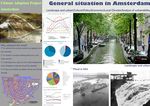
Landscape and urban context
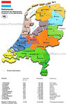
- Amsterdam is the the capital of the Netherlands and largest city with a population of more than 750,000. It is located in the province of North Holland in the west of the country. At first, Amsterdam was a small fishing village, founded around the 13th century, when fisherman living along the banks of the River Amstel built a bridge across the waterway. Wooden doors on the bridge served as a dam, so the Amsterdam's name is derived from Amstelredamme, indicative of the city's origin: a dam in the river Amstel. (http://en.wikipedia.org/wiki/Amsterdam#Cityscape_and_architecture). During the 17th century (also known as Dutch Golden Age), Amsterdam became one of the most important ports in the world and centre of world economy.
- In the same century Amsterdam got most of the current canals, by which it is known today (as "Venice of the North"). At that time canals were built in a form of three concentric semi-circular canals around the old city center. Developing of the city brought the formation of many streets and smaller canals which intersected the three main canals. That created 90 islands and 1.280 bridges. (http://www.aviewoncities.com/amsterdam/canals.htm). The oldest bridge is Torensluis which was completed in 1648 and is still in its original state.
In 2010, the canal district was added to the UNESCO World Heritage List. Part of what makes this district so unique is the canal houses, mostly built in 17th century, as well as the canals. These town houses served as homes as well as workplaces. Except the canals, Amsterdam have two major rivers – Amstel and IJ (which was once a major shipping harbour).
- Population
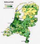
The Netherlands is the most populated country in the world with 477 people per square kilometer of the land. Amsterdam has a population of 800,000 inhabitants, of which 49.5% Dutch and 50.5% foreigners (which tells us that Amsterdam is open and tolerant society).
- Transport
The Netherlands has an excellent infrastructure of ports, airports, and roadways. In the city of Amsterdam, especially in its center, driving a car is discouraged, mostly by expensive parking fees and many streets are closed to cars or are one-way. There are sixteen tram lines, and four metro lines. Also, three free ferries carry pedestrians and cyclists across the IJ to the North of Amsterdam. Amsterdam has ten railway stations.
- Cycling is the most popular mode of transportation in the city. Flat land surface allows movement without barriers. Amsterdam is known as bicycle-friendly city with strong bicycling culture, and all the necessary infrastructure to support it (such as bike racks and bike paths – around 400km of bike paths). Bicycles are used by all socio-economic groups. (http://amsterdam.wiki.cliffordtatum.com/wiki/Bicycling_Infrastructure).
- Biodiversity
Amsterdam has a detaild catalogue about wildlife and nature, which includes about 10,000 species of flora and fauna. The Flora and Fauna Act came into force on 1 April 2002 and is aimed at protecting the biodiversity of the Netherlands, in line with European agreements. Several of Amsterdam’s green corridors are part of the Provincial Ecological Network. By establishing corridors between these areas, flora and fauna can disperse more easily, so they are better able to withstand negative environmental impacts. (http://www.amsterdam.nl/gemeente/organisatie-diensten/dienst-ruimtelijke/making-amsterdam/planamsterdam-magazi/2009/8-2009_amsterdam's/) Regardless all the acts, biodiversity in the Netherlands is slowly decreasing over the past century. A large decrease can be seen in both population size and distribution area, with low biodiversity level. About 8 % of the Dutch breeding birds, mammals, reptiles, amphibians and butterflies have become extinct, and about 40 % of current species are listed on the Dutch Red Lists as vulnerable, endangered or critically endangered. Increasing of introduced (alien) species is noticeable. They enter the Netherlands via new water connections and international transport routes. Climate change causes shifts in species distribution, which means that populations with a preference for a cool environment are decreasing, while species that prefer a warmer climate are increasing. Land use There are several areas in Amsterdam, divided by the current land use: • residential areas • employment areas • infrastructure • agriculture • recreational areas • surface water (http://www.lumos.info/landusescanner.php) Due to the high population density in the Netherlands land has become main problem. As the population is growing, housing, industrial production and transportation continue to require more land. These land-use changes have negative impacts on the availability and suitability of the land for biodiversity, recreation and agriculture. During the period between 2002 and 2005, more than 40 % of new housing was built within existing urban areas in most provinces.


Cultural/social/political context
Amsterdam Culture
From the 1970s onwards significant immigration to Amsterdam takes place from Suriname and Southern countries such as Turkey and Morocco. The result is that Amsterdam is now amongst the most culturally diverse cities of the world: 37% of the inhabitants belong to an ethnic minority group. The ‘urban melting pot’ which Amsterdam is becoming has its positive as well as negative sides. On the negative side, the labor market position of foreign migrants appeared to be very weak with high unemployment rates (even among the second generation), which led to increasing socio-economic and ethnic tensions in the city (Nijkamp, 2009: 1). On the positive side, Amsterdam witnesses a profound transformation based on creative cultures. This new orientation does not only provide a new dynamism for the city, it also has a symbolic value by showing the historical strength of these places as foundation stones for a new and open future. Migrant entrepreneurs also form a significant part of the SME sector in Amsterdam and may hence be important vehicles for urban vitality. Nowadays Amsterdam is swiftly transforming into a services oriented economy. Despite the current worldwide economic downturn, it has favorable growth prospects. Amsterdam is an international harbour city with a vast array of cultural venues. It's a place where the architecture is diverse, where the museums and art galleries are plentiful and where the music scene hosts numerous festivals which are popular among visitors from all over the world. Theatre, opera and ballet admirers will find that the performances staged in this city are of the highest artistic value.(http://www.europe-cities.com/en/600/netherlands/amsterdam/culture/)
Amsterdam Policy and Economics
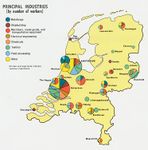
Netherlands and Amsterdam being one of the founding members of the European union sees itself as being at right at the heart of not only it but Europe in general and with it's prime location and major ports it gives it easy access to all the major European markets.(http://www.amsterdamescape.com/business.html) The economic structure of the Amsterdam metropolitan area is largely determined by the city of Amsterdam, which functions as a key hub for international trade. Due to its position along waterways and close to the North Sea, Amsterdam has always been a city highly focused on trade. Newly developed offices and businesses such as the Amsteltoren, the World Trade Center and Teleport now dominate the skyline of the Zuidas. Amsterdam also aims to be an attractive city for high-tech companies and new media ventures. Over the last few years, the city developed into a prominent IT-cluster and currently has the highest concentration of IT companies in the Netherlands. As Figure shows, the economy of the Amsterdam metropolitan area is nowadays highly oriented towards the tertiary sector. Compared with other parts of the Netherlands, the tourism sector of the Amsterdam metropolitan area is an important pillar of the regional economy. Over 2007, the metropolitan region attracted 7 million hotel guests (O S Amsterdam, 2008a). Figure shows how the employment by sector in the city of Amsterdam has developed over the past 15 years.


Legal framework
Netherlands legal framework followed by The European Union system. In 2011, the Netherlands redesigned large parts of its existing laws and adopted new legislation specifically aimed at increased coastal adaptation efforts because of climate change. The new laws partly follow from EU Directives in the field of water and marine law, so an examination of the Netherlands reforms also serves as a lens through which to consider the EU’s approach to coastal adaptation. Illustration: Bullet points, image, background notes
Local Climate
Climate in Netherlands is temperate martime climate influenced by the North Sea and Atlantic Ocen, with cool summers and moderate winters. The country is small, so there is little variation in climate from region to region. Rainfall is distributed throughout the year, but the dryer period is from April to September. Winds from the east can cause more continental type of weather, warm and dry in the summer, but cold in the winter (with temperatures below zero). The climate in Amsterdam is similar to British climate, with occasional temperature extremes which are similar to continetal climate in Germany.
Amsterdam's weather is variable and changes can occur quite quickly. Spring and autumn in Amsterdam can be particularly changeable but the coldest weather is usually in the months from December to March and clear frosty days can be frequent but snow is unlikely. http://www.amsterdam.world-guides.com/weather.html The average temperature in Amsteram is 9.6°C. The range of monthly temperatures is 16°C. The warmest average high temperature is 22°C, in July and August. The coolest average high temperature is -1°C, in January and February. Annually precipitation is on average 766mm, or 64mm each month. On balance there are 217 days annually on which greater than 0.1mm of precipitation occurs. The month with the driest weather is March, with 44mm of precipitation. The wettest month is August, with 87mm of precipitation. Relative humidity is 77.3%. Hours of sunshine vary from 1.3 in December to 7.4 per day in June. There are 1568 sunshine hours annually, which is approximately 4.3 sunlight hours for each day. http://www.amsterdam.climatemps.com/

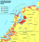
Amsterdam, the capital of Netherlands, due it's position in low flat land and nearness of the North sea is pretty much threathened by floods. Floods were common phenomenon during the history, as much they are today. On 14th December 1287, St. Lucia's flood affected Netherlands and Germany, and killed more than 50.000 people in one of the most destructive floods recorded in history. The St. Elizabeth flood in 1421 destroyed a newly reclaimed polder replacing it with the 72-square-kilometre tidal floodplains in the south-centre. One of the greatest recent floods occured in early February 1953, which brought water level 15 feet above normal. The damage was enormous and over 1800 people lost their lives. After that disaster, in order to prevent such a atastrophe in the future, the Dutch water authorities decided to reinforce and increase the height of all dikes (including river dikes) and levies in the Netherlands, all the way up to the German border. The project started in 1960s, known as Delta Plan. The construction of dams in the estuaries led to an unexpected problem: the closure of the estuaries led to a slower discharge of the river into the North Sea and accumulation of sediment on the rivers, resulting in shallower river channels and the need for higher dikes. Nowadays, the Dutch are trying to adapt to this disasters, caused by rising sea level, by predicting rises in Rhine river levels and rebuilding mangrove swamps to temper rising ocean waters. One of their biggest projects for the future is constructing a series of campgrounds and recreational areas called Wadden Works, which will act as a buffer against rising sea levels and floods before the waters even reach the dikes.
http://bluelivingideas.com/2009/09/09/rising-sea-levels-amsterdam-teach-world/ http://www.eh-resources.org/floods.html
Analysis of vulnerability
Oscillations in sea level occured periodically during the history of Netherlands. Today, with all the consequences of climate changes, flooding is expected more often. Except the relatively new factor – the change of climate, vulnerbility of Amsterdam is based on the morphology of the terrain. More than half of Netherlands sits below sea level. Basically, Netherlands lays on alluvial plain, built up from sediment left by thousands of years of flooding by rivers and sea. To protect themselves from floods, first permanent inhabitants had to build their homes on artificial dwelling hills. Since 1900 sea level rise of the North Sea near the Dutch coast has been 19cm. Built mostly below sea level, the country is dependent on a series of man-made dikes, as well as natural dunes, that keep water from the North Sea and the country's three major rivers at bay. Almost two thirds of the Netherlands is prone to flooding. Higher grounds within the dike rings are not prone to flooding - about half of the urban area and population within these dike rings are in the flood-prone zone. Currently, the network is designed to protect the coast against a 10.000-year flood, that is, a flood that has a one in 10.000 chance of breaching the country's weakest barriers within any year. Sea level rise and land subsidence will accelerate in the future, which will bring serious problems, especially in the lower-lying regions. Due to climate change and relative sea-level rise, the dikes will eventually have to be made higher and wider.


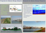
Proposals for Climate Change Adaption
During the history, flood risk management in the Netherlands was mainly based on building high dikes which are strong enough to prevent floods. This strategy carried on for 1000 years, and Dutch coastiline is now completely relying on dikes-flood defence system. With the climate changes, which are more than visible today, some new adaptation measures should be discussed, especially as we know that Netherlands long coastline (about 1000 km, with all the estuaries) makes her vulnerable to floods. In the future, there is an 80% chance that the sea level in 2050 will be 15 to 35 cm higher than in 1990, and for 2100 sea level rise of the North Sea of 35 to 85 cm is projected (by Royal Netherlands Meteorological Institute). All this is estimated due to melting ice sheets in Greenland and Antartica, which will cause rising of global sea level. There are few measures which can be taken to ensure and improve today's situation. This involves not only technical measures, but also landscape and land use measures to ensure a more secure and robust water system. One of most naturall measures includes expaniding the coastilne by sand repelenishment. Sand can be dredged from the bottom of the North Sea and naturally distributed towards the shoreline. This will enable the coastal zone to grow concurrently with the rise in sea level.
Other solutions includes: - to build even higher and stronger dikes, which is not desirable – they will negatively affect the image of the landscape. - to withdrawal to the higher grounds, by gradual relocation of companies, plants and infrastructure to the higher eastern part of the country - not to build new infrastructure close to the shoreline - usage of new, resilient methods in architecture

.jpg)


Proposals for Climate Change Mitigation
Firstly, all existing vegetation should be preserved, as the plants are natural filter for the pollutants, both gas and particles. Knowing that the plants are producing oxygen and adopting CO2, there should be even more tree vegetation, such as green corridors which will navigate wind and trough this moving out polluted air from the cities (gases from transportation and industry). Around Amsterdam and other big cities of Netherlands are vast areas with no tree vegetation. There could be situated solar plants, wind plants and other alternative energy productions which will reduce coal usage. The greenery along the coastline will reduce coastal erosion). Bringing green areas in the city will preserve wildlife biodiversity, as well as increase it. Netherland is already known as windy country, and is famous because of its old windmills. They were used from centuries to pump out water and Windmill tradition never stopped in Netherlands. Nowadays, windmills have new technological ‘face’ - ‘environmental friendly’ energy producers. There should be even more wind farms, beside the existing ones in the North Sea and take the benefits from it.

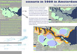
Your scenario
By 2060, population in Netherlands will rise in about 3%, which is approximately 376 000 inhabitants. Given the fact that in the future sea level will rise, together with greenhouse emissions (resulting from rapid global urbanisation), we propose combinig techiques: for greenhouse reduction and preventing flooding. Our goal is to create fossil-free region for the coastal line of Netherlands, by focusing on producing energy only from renewable sources (wind and sun), which Netherland already started. Also, creating green „urban pockets“ and green walls in the city, with creating big green zones around Amsterdam will have positive effect on reducing the heat island effect.
For flooding prevention, all coastal lines should be wider and filled up with sand, which will give them natural look. Where this cannot be done, dikes will stay, forming a kind of natural landscape with boulder clusters and native plants on the surface. On the other hand, flooded areas can be used for saline agriculture (breeding of salt-tolerant plants), with relocation of cities on higher eastern part of the country. There will be a lack of fresh water, so we propose creating artificial lakes-rainfall colectors, with reed-bad filtration system where is possible. This purified water can be used for irrigation and for household consumption.
Sustainable architecture, which includes water-resilient buildings, should be used in vulnerable coastal areas.


![[1]](/index.php?title=File:Persbeeld_BREATHING_W_architecture_klein.jpg)
![[2]](/index.php?title=File:Persbeeld_GLIMPSE_spaceandmatter_klein.jpg)
![[3]](/index.php?title=File:Persbeeld_BREATHING_Delva_and_Deijs_klein.jpg)


What can be generalized from this case study?
Amsterdam as a coastal city is mainly facing the threat from floorings. This could be prevented by levees and dikes. Worming in the north countries means more vegetation days for plants which is good from one side but negative on the other because of invading wormlike plants. Wind masses are moving freely through the flat planes in Netherlands which cast out polluted air. This process could be improved by green corridors.
Presentation Slides
-
 Slide One
 -
 Slide Two
 -
 Slide Three
.jpg)
.jpg)

Image Gallery
-
-
-
-
-
-

-
 Amsterdam
 -
 Land reclamation
 -
your image text
-
your image text
-
your image text
-
your image text
-
your image text
-
your image text


References
Source of image 1. /http://bs.wikipedia.org/wiki/Amsterdam 2. /http://upload.wikimedia.org/wikipedia/commons/4/46/EU_location_NED.png 3. /http://www.vidiani.com/maps/maps_of_europe/maps_of_netherlands/road_map_of_netherlands.jpg 4. /http://www.planetware.com/map/netherlands-kingdom-of-the-netherlands-map-nl-nlreg.htm 5. /http://maps.nationmaster.com/country/nl/1 6. /http://www.worldatlas.com/webimage/countrys/europe/lgcolor/nlcolorlf.htm
About categories: You can add more categories with this tag: "", add your categories
{{#widget:WidgetName|param1=value1|param2=value2}}