Green links for Wilhelmsburg
Green links for Wilhelmsburg, a neighbourhood of Hamburg, Germany, by Isin Barut
--> Back to Rural Landscapes Seminar Case Study List
| Name | Green Links for Wilhelmsburg | |
| Location | Wilhelmsburg/Hamburg | |
| Country | Germany | |
| Topic | creating green links for metropolitan landscapes-connecting peri-urban, rural, urban spaces with green links | |
| Office | office or planner/designer | |
| Client | Hamburg-Mitte | |
| Completion | Please enter the date of completion | |
| Project costs | Please enter the costs (if known) | |
| Case study author(s) | Işın Barut | |

| ||
| <googlemap version="0.9" lat="53.512347" lon="9.992752" type="satellite" width="300" height="250">
</googlemap> | ||
Rationale: Why is this case study interesting?
- Please summarise:- e.g. Design Innovation? Planning Exemplar? Theoretical Insights? Lessons learned from its failure?
Hamburg is one of the most important port trade center in Europe and as a district of Hamburg Wilhelmsburg has a good potential and attractiveneness by having a commercial port in the west. Thats why %43,2 inhabitants are immigrants from 40 different nationalities in Wilhelmsburg. Besides this cultural variety Wilhelmsburg also has special landscape characters and unique landscape elements (dikes, ditches, marshland etc.) Except various contrasts between people and the island has a big avareness problem. Many people live in Hamburg has never been in Wilhelmsburg and many people dont know that its the biggest river island in europe. And there is a metropolitan pressure to the island as the result of stucking between 2 big metropolis: Hamburg and Harburg. To solve these problems planning and desgin proposals will integrate and develop the area. The main proposal will be 'linking green areas' has two meanings in this step: -to create visual links between landscapes -to create a mental links between different nationalities Social problems will be solved by useing design and planning approachs together, it makes this project more interesting. For instance mental and visual links will be created for social and visual integrity.
- Think about it from the view of another educator/student in a different country. Why should I use this case study in my teaching/education?
This project will show what kind of design and planning principles can be used for an european island located beetween metropolitans. Also how flora and fauna been kept in green links concept. What kind of linking approachs can be used for area problems and social problems? This project will be an example after seeing the results of planning&desgin success for solving integration problems and developping an island to reach the same quality with Hamburg city.
Author's perspective
- What theoretical or professional perspective do you bring to the case study? Please answer from your personal perspective.
From the planning perspective it needs to be generated and developped to make the island more liveabe and keep the special character of the landscape. In this respect this project will give the results of a questions needs to be unswered for the island: -'How Landscape planning and Lansdcape architecture skills create rationalist solutions for a special area...' -What are the inputs of planning and design together?
The planning and design approach will be:
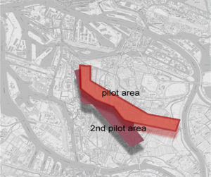
1.Designating a pilot area
2.Designating a second pilot area closed to first pilot area
3.Focusing on a suitible area for design approach
4.Detailing a modal area in a smaller scale
5.Explaning the results of the project principles
Furthermore the idea is Linking the Green Areas in Wilhelmsburg Island. This planning proposal will be generated with design skills.
Landscape and/or urban context
- Biogeography, cultural features, overall character, history and dynamics
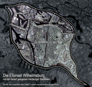
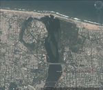
Wilhelmsburg is a district of Hamburg/Germany within the borough (Bezirk) of Hamburg-Mitte. It is situated on an island between the Northern and Southern branches of the Elbe river (Norderelbe and Süderelbe), together with the other quarters of Steinwerder, Veddel and Kleiner Grasbrook. The latter almost exclusively consists of facilities of the port of Hamburg. The four quarters are technically all islands of their own, as they are all separated by their own dams.
In 2006 according to the statistical office of Hamburg and Schleswig-Holstein, the district Wilhelmsburg has a total area of 35.3 square kilometres (14 sq mi). Wihelmsburg borders in the north to the quarters Steinwerder, Kleiner Grasbrook and Veddel. In the east are the quarters Spadenland and Ochsenwerder of the Bergedorf borough. In the south are the quarters Neuland and Harburg of the Harburg borough and the state of Lower Saxony and in the east are the quarters Moorburg and Altenwerder of the Harburg borough.
-
 Wilhelmsburg island with Elbe river

History: In 1642, George William, Duke of Brunswick-Lüneburg acquired three islets in the river Elbe and connected them by means of dams. The resultant island was named Wilhelmsburg in his honour.
In 1705, Wilhelmsburg became part of the Hanoverian state, which then subsequently became the Prussian Province of Hanover in 1866. In 1925 the Prussian authorities designated Wilhelmsburg as a city district, and merged it with nearby Harburg two years later to form the city of Harburg-Wilhelmsburg.
In 1937, Harburg-Wilhelmsburg, along with the cities from the Prussian Province of Schleswig-Holstein, Altona and Wandsbek, was annexed to Hamburg in the Greater Hamburg Act.
During World War II the port of Hamburg and therefore Wilhelmsburg were targets of the air raids of the so called Operation Gomorrah. A subcamp to the Neuengamme concentration camp existed in Wilhelmsburg.
In the night from February 16 to February 17, 1962 Wilhelmsburg was widely flooded and seriously damaged by a north sea flood. On the river Elbe, but a full 100 km away from the coast, the residential area of Wilhelmsburg was most affected.
On March 1, 2008 Wilhelmsburg was transferred from the borough Harburg to the borough Hamburg-Mitte by a Hamburg law.
Nowadays Wilhelmsburg hosts different development projects like IGS 2013(international garden show) and IBA(international building)
Wilhelmsburg has a high socia-cultural variety becouse of including 40 different nationalities. Internationality is one of the strongest aspect for the cultural context of the island. There are different life styles and cultures. Every ethnic group has its own raditions. Approximitely %77 percent foreigners are turkish.
The island has not so much cultural event options,generally people prefer to go Hamburg for cultural attractions. The island has a good rail way connection to main train station of Hamburg so inhabitants of Wilhelmsburg has a chance to join several cultural attreactions and events in Hamburg. Additionally Since 2007, the music and art festival Dockville takes place every year in summer.
Overall character of Wilhelmsburg Wilhelmsburg island is the biggest district of Elbe island, it is surrounded with 3 more districts in elbe island and takes parth in the south. There are different landscape characters in the island:
1.Nature protectian area
2.Marsh land
3.Residential area
4.Industrial area
5.Agricultural area
6.Recreatinal green open spaces
The landscape character of the island in not clear becouse its very mixed and distrubuted. but the main eye cather unique landscape character elements are:
-Dikes
-Ditches
-Marshes
-Agricultural patterns
-Allotment gardens [edit] Notes
Cultural/social/political context
- Brief explanation of culture, political economy, legal framework
Demographics: Wilhelmsburg is situated in between, and is home to almost 50,000 inhabitants - including many port and industrial workers. The area has high numbers of immigrant residents, but is also rich in picturesque waterfront locations. Wilhelmsburg is cut off from the development poles north and south of the river by the Elbe River. The island community of Wilhelmsburg has experienced social difficulties including high unemployment, poverty and crime for some time. In 2006 there were 7,204 criminal offences (147 crimes per 1,000 people).
In 2006 Wilhelmsburg had 49,132 inhabitants. 22.6% of the population were under the age of 18, and 14.6% were 65 years of age or older. 33.7% were resident aliens. 4,298 people were registered as unemployed.
In 1999 there were 21,345 households out of which 26.8% had children under the age of 18 living with them and 39.9% of all households were made up of individuals.
The average household size was 2.18.
A move to the far right in recent elections and intense protests against a proposal to install a waste incinerator in the area have contributed to a poor image and reputation for this section of the waterfront.
History
- How did the area/project/plan at the focus of the case study evolve?
For the study evolve, as in Historical context Historical landscape changes and the development needs to be explained:
Before the 15th century Wilhelmsburg Island area used to be devided to several islets which are surrounded by river elbe. There were not residentials at this period but the islets were covered with marshes and sands. Small part of the islets were used by farmers. Historic maps shows that after the 15th century there were still several islets surrounded by water channels and sandbanks. The Elbe river used to make floods and change the landscape.
After 15th century systematic landscape changes continued: riverscape through canalisation, diversion of the river, removal of banks and landfill... Later in the 17th century three islets in the river Elbe connected by means of dams by the duke George Wilhelm from whom the island took its name. In resultant island, in 1814 a four-kilometre wooden bridge across the Elbe island constructed by Napoleon‘s troops. After that, industrialization increased more and the port of the island had more importance. Workers and migrants population suddenly increased.
-1852: first road in Wilhelsburg-George Wilhelm Strasse -1970: the commercial port enlarged and containers took a bigger part in the harbour -1872: First Iron Elbe Bridge constracted with the construction of the railway
In 1888 freeport is established therefore industrialization enlarged, Elbe islands eveloated to a more structural view. Wilhelmsburg district developped into an industirial area, new docks were constracted, a petrol harbour accured.
Until the 19th century land uses continued as agriculture, dairy farming, commercial port uses. From the middle 19th century roads and canals were built, factories enlarged and hausing development increased.
-1904: Town hall was constructed in the geographical centre of the island(unterelbe region) -1920ts: Block forming residentals accured, natural urban residental area planned for development of the island
In 1925 Wilhelmsburg designated as a district and in 1937 annexed to Hamburg. Later in 1962 a great flood destroyed the island and the residential protection became more important. In 1938 transportation link was created and between 1941-1944 general local plans was accured: -Blocks of flats extended with industrial development -Since 1960, port industry continued developping In 1970 the port moved west and port development continued.
In the 21th century Hamburg had the new vision of the metropolitan city and planners started to think about leaping the Elbe. In 2003 Olympics planners and garden-show find the empty spaces in Wilhelmsburg. In 2006 the Elbe islands became officially planning landscapes: IBA Hamburg and igs 2013 focus the visions and their implementation until 2013.
-
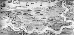 After the 15th century: Farm lands, small channels, river beds, sandbanks, islands
 -
 1621, Wilhelmsburg islands
 -
 1700, Wilhelmsburg islands


Spatial analysis of area/project/plan
- What are the main structural features?
- How has it been shaped? Were there any critical decisions?
Infrastructure:
Transportation system: Wilhelmsburg is serviced by the rapid transit system of the city train with the Wilhelmsburg station. In 1983, the first part of Hamburg's southern S-Bahn line from Central Station toward Harburg were completed and opened with the new Wilhelmsburg station. The railway station is located in the quarter Wilhelmsburg in the Hamburg-Mitte borough of the city of Hamburg, Germany.
Wilhelmsburg is serviced by the rapid transit system of the city train with the Wilhelmsburg station. In 1983, the first part of Hamburg's southern S-Bahn line from Central Station toward Harburg were completed and opened with the new Wilhelmsburg station. The railway station is located in the quarter Wilhelmsburg in the Hamburg-Mitte borough of the city of Hamburg, Germany.
The Köhlbrandbrücke is a major connection from Wilhelmsburg to the nearby motorway 7. According to the Department of Motor Vehicles (Kraftfahrt-Bundesamt), in the quarter Wilhelmsburg were 13,714 private cars registered (280 cars/1,000 people).
-
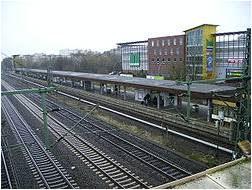 railway station

Main structural features:
- Transportation ways:railway, bus routes, bicycle routes
- Elbe river
- Canals, ditches
- Dikes, fences, sandy banks
- Agricultural fields, allotment gardens
- Industrial constructions
- Residentials
Criticals:
-Elbe river has the biggest affect to the island shape, becouse of its regularly floods. Especially south of the island had influences from Elbe river
-Current planning projects make structural changes in the island (IGS 2013, IBA)
Analysis of program/function
- What are the main functional characteristics?
- Industry
- Agricultural productions
- Potential special landscape (characteristic types)
- Diversity of the species
- High percent of Young inhabitants
- Allotment gardens
- IBA for residential development
- IGS 2013 for creating greenery and making connections in the landscape and people either
- How have they been expressed or incorporated?
Analysis of design/planning process
- How was the area/project/plan formulated and implemented?
- Were there any important consultations/collaborations?
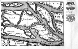
1:First of all the main problems are designated on the map(analysis depends on interviews with locals and surveys, also some informations from IGS are used by this project
problems
-missing links in the island
-barriers(rail way, highways)
-missing view points
-missing access
Wilhelmsburg has good potential for transportation but it needs to be improved becouse of the missing accessible areas between different landscape types also the island has no visibility in some areas besides having view points which are not connected and divided with landscape barriers like railway or highways
2:After overlaying the problem areas for the planning approach designated potential areas(includes suitable open spaces for implementation and places people like) also overlayed and finally a yellow zone chosed for planning&design proposal area. This zone had stressed as a model area for planning&design approach
-
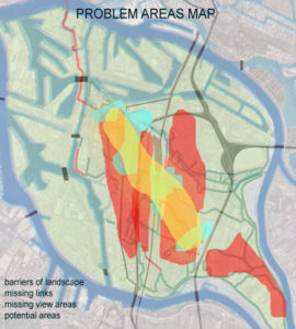 Overlaying problem zones with potential zones

3: Main goals for the designated area are determinated and pilot area found beneficial to stress this goals:
-Improve accessibility
-Improve visibility
-Improve neighbourhoods
-Enhance street life
-Manage streets
-Enhance island character
-Sustainable landscape management
-Keep the green structure
-Create more oportunities
-Coherent design
-
 Overlaying problem zones with potential zones

Analysis of use/users
- How is the area/project/plan used and by whom?
- Is the use changing? Are there any issues?
- Wilhelmsburg is located between two big cities and its reachable by trainways, highways also pedestrian bridges. It is reachable from other cities so short term user groups can always change.
- There is not a big tourism sector so tourists does not take big place in user groups list.
- Furthermore current planning&design projects make changeings about user groups, nowadays wilhelmsburg hosts academic events like workshops or research projects. The island is getting more and more well-known.
Main landuses:
-protection area
-recreational poen spaces
-agricultural area
-wetlands
-industrial areas
Cross-cutting questions
How may landscape architecture contribute to the integration of different user groups in the urban fringe?
- Integration in an urban area
- Quality of life in rur-urban areas
- Flexibility of life styles

Why do people meet?
-Education -Sharing experiences and discussing -Relaxing(doing group sports, dancing etc...) -Creating something -Not to feel themselfs alone
What should the planner and designer generate?
-If we give people a quality area and good functions about the place then the usage will suddenly increases
Quality:
-Accessible places -Peacefull atmosphere-by useing natural values with design elements -Useing contrasts
Variety:
-Make people reflect their own interests and give them places to meet under the same intrest -Events for public participation -Different leisure activity facilities
Continuousness: This function is very important for this project to keep the given places and given functions alive
How can the transformation process be connected with the landscape sub-typologies?
- where does rural start?
- Rur-urban
- Dynamics flows between urban and peri-urban areas
- Monitoring land-use change
To understand the transformation process firstly the effectives of the changes should be clear. And related to subtypologies landscape management is the most affecting aspect for transformation progress. For different kind of typologies the management of the landscape should be different. And management approachs with climate affects and human affects the landscape be changed suddenly. In urban areas changing process could be faster than rural changes becouse of the more human affects, structuralism can make big pressure to this typologies and in short term the landscape can be transformed deeply. In addition rural areas can transform urban areas and sub-typologies can intermix but generally this two typologies have transitions to manage them better. Can we say rural starts where urban ends? There should be a transititon zone for flora and fauna. Rur-urban areas can take on this role.
How may landscape planning contribute to quality improvement?
- Aesthetic quality
- Environmental quality
- Social quality
Landscape planning directly improve the quality of life becose it gives oppotunity to use landscape intelligently for future needs and influences to the landscape as well as human,flora and fauna. Planning proposals give solutions for human integrity and other problems so after that social quality directly increase. Aesthetic quality contains two point, one is the usage of the landscape other is visual meanings of aesthetics; planning projects definitely improve the landscape usage quality what if landscape design coorparate with planning projects? Aesthetic quality increase more with cooperations of design proposals.
Can the maintenance and development of agricultural land-use in urban fringes be a strategy of a greenbelt?
- Agriculture in the urban fringe
- Agriculture as a green infrastructure element
- Green infrastructure
- Creating green links for wholeness
- Greenbelt, agriculture as a part of it
Maintenance and development of agricultural land-use in urban fringes can be a strategy of Green Belt concept. The beneficial issues of this strategy are:
- Intereaction of different landscape characters, creating contrasts
- Productive landscape fringes between hard constractions
- Sustainable design with agricultural patterns
- Public participation in urban areas
- Extreme visual design with soft agricultural surfaces near by residentials-it can be an opportunity of attractiveness
- Benefits to the flora, fauna
Agricultural fringes can also become recreational areas without human pressure and develop the rural areas for more greenery. Further more this strategy might be the most attractive way to connect urban fringes with rural fringes. Its mean is that rural fringes can create coherent design and productive opportunities with supporting economy and visual quality together.
Future development directions
- How is the area/project/plan evolving?
- Are there any future goals?
Illustration: Map/diagram/sketches photos and background notes
Wilhelmsburg will be changes under the strategy of this project:
-Create grren view towers connected with green streets and various transportation system!
Future goals are:
-Enhance the street life
- for integration, improving neighbourhoods
- for connection, reachable ways from houses

-The idea behind this strategy is to stress island character more by improving visibility. This idea will be implemented by:
- Sustainable sightseeing towers
- Cable railway system
- Suspension railway system
- Treetop paths
-With useing the streets between residentials street life will be emphesized and streets will become more alive. Especially nignt usage will be generated with special colorfull lighting system. In detail exhibitions, art works, street dance, competitions, concerts will be offered for social interaction. In design details the shape of the island(tear of the Hamburg) will be seen in patterns, builging surfaces etc. Or identific island characters like dikes will be used for different functions(as a bench, an exhibition table etc).
This solution also will offer sustainable solutions:
- In wilhelmsburg bus routes are very efficient to reach nearly every area and people use bus system inside the island. Thats why this project is offering to transform bus system to E-bus concept. by useing E-bus system, there wont be any damage to flora and fauna, also it will be fuel efficiant and a this concept will be a model for sustainable island transportation.
- Sightseeing towers will keep solar energy with solar pannels on the top and use it for lighting system. Also towers will keep the rainwater.
- The excistinf highways in wilhelmsburg will be transformed to green street model. by this way storm waters will be kept for planting and further attractions.
- Especially trasportation options will become more funny for young people this project will create a new cable railway system and treetop paths. By this way there wont be a damage to nature in access facilities.
Peer reviews or critique
- Has the area/ project/plan been reviewed by academic or professional reviewers?
- What were their main evaluations?
There are 2 kind of current project-IGS and IBA- for Wilhelmsburg that consistits academic/professional managers:
1.Idea behind IGS 2013: Wilhelmsburg is hosting for an International Garden Exhibition in 2013. With IGS project Wilhelsburg will be developped for integration between people and new open spaces will be created in 2013. Besides making a social district development new green links will be crated to connect different landscapes.
2.Idea behind IBA:Wilhelmsburg wll have another wiev of residental development. Buildings will be sustainable and environmental friendly. In implementation buildings will be combined with social and cultural activities.
Points of success and limitations
- What do you see as the main points of success and limitations of the area/project/plan?
Success points:
- Special island landscape
- Port trade power
- Current development projects
- Young inhabitants
- With this project, increased adn developped neighbourhoods and more attractive accessbility and visibility with new transportation systems and view points
Limitations:
- Conflicts between different ethnic groups
- Unemployement
- Immigration and emigration-especially german locals are leaving Wilhelmsburg
- Undefined open spaces
- High apartments in the island-hinders the visibility
What can be generalized from this case study?
- Are there any important theoretical insights?
Short statement plus background notes
- Interview techniques are very important for the project areas include several social problems
- Metropolitan pressure on a special designated area can be prevented by creating connections to that areas
- Accessbility and visibility are very important for keeping a special area character
Which research questions does it generate?
Short statement plus background notes
- How people can be adapted to the results of development projects?
-How long does it take to be adapted to a new living open spaces?
- How successfull is creating solutions for social problems by useing the landscape, are there much successful examples from different european countiries?
- What are the results of improving the accessibiliy an visibility together for development of an peri-urban area.
Image Gallery
-
 The Pilot Area/ (agricultural patterns with ditches and residential area)
 -
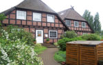 Original Buildings closed to the Center
 -
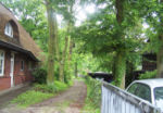 An Image of the Private Residents Area
 -
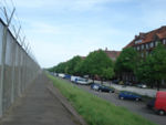 North Side of the Wilhelmsburg/ (unique fence on dike)
 -

-
 South side of the Wilhelmsburg/ (Unique marshland)
 -
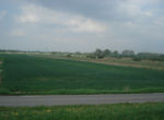 An Image of the Agricultural Area on the South
 -
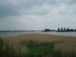 An Image of Südern Elbe and Characteristic Marshland


References
Please add literature, documentations and weblinks
Web sites:
PDF documents and PPT files
- IBA Hamburg Cultural Landscapes/ Uli Hellweg
- Pimp My City-Diplomarbeit Stadtpalnung/ Samy D. Schneider
- Wilhelmsburg Historic Context/ Prof. Jens Usadel
About categories: You can add more categories with this tag: "", add your categories