Green Infrastructure 2014 Working Group Q- Case Study 1
---> back to group page working group Q
GUADALUPE RIVER IN SILICON VALLEY
| Name | Guadalupe River / Ulistac Nature Preserve | |||||||||||
| Country | California, USA | |||||||||||
| City | Santa Clara/San José | |||||||||||
| Authors | Andrés Pérez | |||||||||||

| ||||||||||||
| {{#widget:GoogleMaps | width=300 | height=240 | lat=37.40623138077493 | lng=-121.95503698193357 | zoom=15 | centermarker=yes | maptypecontrol=yes | overviewmapcontrol=yes | largemapcontrol=yes | scalecontrol=yes
}} | ||
Rationale: Why is this case interesting?
The cities of San José and Santa Clara (in fact just one city) are lacking green areas and buffer zones, due to agressive urban sprawl. Rivers, highways and railways are the only continuous infrastructures across the city. The Guadalupe river and other similar creeks on the Santa Clara Valley (aka Silicon Valley) are in fact the only green connectors. They are also human/bike scale trails to experience the city. In the middle of the sprawl, Ulistac Green Area has been preserved due to historical reasons, and can be the seed to further developments and ecological buffer zones.
Author's perspective
I am an architect and landscape architect, new to the San Francisco Bay Area. The case is near my appartment, the reason why I chose to live there and nowhere else
Landscape and/or urban context of your case
- Biogeography, cultural features, overall character, history and dynamics
History
Time before the Spanish conquest of California, the Ohlone indians inhabited the site and founded a village called Ulistac. In their language, “tac” means “place,” while Uli was most likely the name of a chief. Thus, Ulistac meant Uli’s place.
The Spanish explorer Juan Bautista de Anza and his team arrived at the site in early 1776. They named the adjacent Guadalupe River (Río de Nuestra Señora de Guadalupe) after the patron saint of their expedition, the Virgin of Guadalupe. De Anza wrote in his journal on March 30,
“To this arroyo or river we gave the name of Guadalupe. It has abundant and good timber of cottonwood, ash, willow, and other kinds. In all directions there is a great abundance of firewood, and likewise agricultural lands for raising crops by natural humidity, or by irrigation if the river is permanent, as we conjecture, in which case it would make possible a large settlement.”
In early 1777, Mission Santa Clara de Asís was stablished. Missionaries recruited native tribesmen to work there and converted them to Catholicism. At the end of the year, El Pueblo de San Jose de Guadalupe was established along the Guadalupe River as the first incorporated city in California.
In 1799, 200 Ohlone native converts planted three rows of willow and poplar trees to create the Alameda which now connects Santa Clara with San José. They dug irrigation canals to divert water from the Guadalupe River to the trees.
After the independence of Mexico from Spain, Rancho Ulistac became a 2,217-acre (8.97 km2) land grant, given in 1845 by Governor Pío Pico to Marcelo and Cristóbal, Ohlone indians from the Santa Clara Mission.
In the early 1940s, the ground was graded and leveled to create a pear orchard as part of the booming fruit industry of the Santa Clara Valley.
A decade later, the land was converted again, this time to become a golf course.
The U.S. Army Corp of Engineers altered the river’s route by constructing 15-foot levees to form a straight channel in the 1960s.
After decades of agressive urban sprawl, the golf course was abandoned and the Ulistac Natura Area became one of the few undeveloped spaces in the area, whose main feature is its connection to the Guadalupe River, which acts in fact as a Green Infrastructure in the valley.
Nature
The current location of the Ulistac Natural Area is the brackish intersection of saltwater wetlands from the Bay and freshwater sources including rivers and groundwater.
- Illustrations: maps; sketches; short descriptive analyses
- Illustrations
-
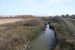 Guadalupe river trail
 -
 your visual
 -
 your visual


Analytical drawings
- Please use analytical drawing for visualising the conflicts/potentials of your site
- Analytical Drawings
-
your drawing
-
your drawing
-
your drawing
-
your drawing
Green Infrastructure benefits for this site
Look again at the multiple benefits of green infrastructure - what could be achieved in your site and which are most relevant?
Potential for multifunctionality
Green infrastructure has typically multiple functions. What could be achieved for your site in this respect?
Projective drawings
- How would you like this case to change in the near future? (in 1-2 years)
- you may add a short explanation here
- And how could it look like in 10-15 years?
- you may add a short explanation here
- Projective Drawings
-
projective drawing
-
projective drawing
-
projective drawing
-
projective drawing
Summary and conclusion
- 100 words approx.
Image Gallery
Please add further images/photos here
- Image Gallery
-
your image text
-
your image text
-
your image text
-
your image text
-
your image text
-
your image text
-
your image text
-
your image text
References
- please add your references here
About categories: You can add more categories with this tag: "", add your categories