Green Infrastructure 2014 Working Group P - Case Study 1
---> back to group page working group P
Green Infrastructure Potential in Atunrase Estate, Gbagada, Lagos State, Nigeria
| Name | Atunrase Estate, Gbagada. | |||||||||||
| Country | Nigeria | |||||||||||
| City | Lagos State | |||||||||||
| Authors | Fadera Williams | |||||||||||

| ||||||||||||
| {{#widget:GoogleMaps | width=300 | height=240 | lat=6.551626° | lng=3.387399° | zoom=10 | centermarker=yes | maptypecontrol=yes | overviewmapcontrol=yes | largemapcontrol=yes | scalecontrol=yes
}} | ||
Rationale: Why is this case interesting?
Nigeria is officially The Federal Republic of Nigeria, is a federal constitutional republic comprising 36 states and its Federal Capital Territory, Abuja. The country is located in West Africa. Lagos, currently the fifth largest city in the world, is the foremost manufacturing and port city in West Africa, and the hub of business and economic development in Nigeria. Lagos grew from 300,000 in 1950 to 10.5 million people in 2010. The growth of Lagos is primarily the result of its location on the west coast of Africa which has fostered the development of trade within its hinterland as well as with the neighbouring states. Atunrase Estate is located in Gbagada area of Lagos Mainland local government area of Lagos State, Nigeria. The estate comprises of 200 plots of land with an estimated 7,000 population. The estate has a potential for green infrastructure because it is compact, it abuts against the line of a drainage canal which has room for urban forestry, and the existing ;landscape setting can accommodate some significant green infrastructure input that will improve the outlook of the Estate.
Fadera Williams is a Landscape Architect who Graduated from the University of Lagos, Nigeria. I happen to live about 20 minutes from my chosen area( Atunrase Estate and it's location and compactness has always drawn my attention to it. I believe if the Green Infrastructure principles are applied to this Estate it will increase the quality of Life of the residents in the area and also its environmental sustainability.
Landscape and/or urban context of your case
- Biogeography, cultural features, overall character, history and dynamics
- Illustrations: maps; sketches; short descriptive analyses
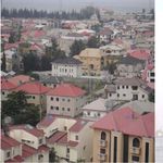
Lagos is the biggest and most important city in the Federation of Nigeria. The country, which is located in the coast of West Africa, consists of 30 states. Nigeria shares borders with Benin, Cameroon and Niger. Lagos is the main city of Lagos State, which is situated in the southwestern coast of Nigeria. The Metropolitan area of Lagos takes up to 37 per cent of the land area of Lagos State and houses about 90 per cents of its population (Unicef 1995, Aina 1990a).
The area of Lagos constitutes of two major regions: the Island, which is the original city and the Mainland, which is made up by rapidly growing settlements. The climate in Lagos is tropical, hot and wet. The environment is characteristic as coastal with wetlands, sandy barrier islands, beaches, low-lying tidal flats and estuaries. The average temperature in Lagos is 27 °C and the annual average rainfall 1532 mm (Aina 1994, Peil 1991).
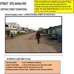
Gbagada has always been a location of choice on the mainland, situated in Lagos Mainland local government. The area is mainly a residential neighbourhood but there is also a flourishing commercial/industrial part to it. Gbagada lies on both sides of the Oworonshoki –Oshodi expressway and comprises several sub-locations. Perhaps the main attraction here is the vantage location which it enjoys. Gbagada has quick accessibility to Lagos Island via the third mainland bridge and the Mainland through Oworonshoki-Oshodi expressway that links Ikorodu road and Agege motor road. Atunrase Estate is located in Gbagada area of Lagos Mainland local government area of Lagos State, Nigeria. The history of Atunrase Estate dates back to October 1st 1981, which was the date of the first road construction in that estate. It was a property which originally belonged to the Oloto Family of Oto, in Lagos State until it was purchased by Mr Sam Bola Atunrase. The estate comprises of 200 plots of land with an estimated 7,000 population. There is a drainage canal which was constructed by the Lagos State Government which is the boundary of the Estate.
- Illustrations
-
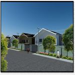
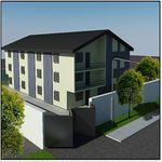
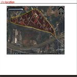
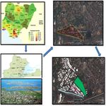 Site location maps
 -
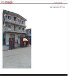
 Site location pic
 -
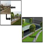
 Street road map visual


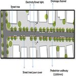
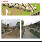
Analytical drawings
- Please use analytical drawing for visualising the conflicts/potentials of your site
- Analytical Drawings
-
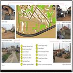
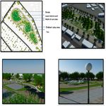
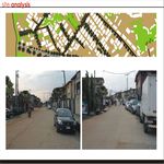
 ANALYSIS 1
 -
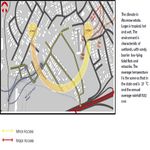
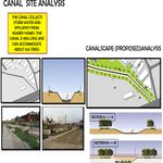 ANALYSIS 2
 -
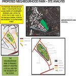 ANALYSIS 3
 -
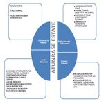 GI POTENTIAL CHART


Green Infrastructure benefits for this site
Green Infrastructure development for a residential estate can offer a lot of benefits to the residents. This would encourage pedestrianization, reduce the dependence on vehicular transportation since the whole estate can be navigated in just about 35 minutes on foot but most people depend on their cars or the public motorbikes popularly known as ‘okada’ . used in the estate. There is another estate which can be accessed through the canal area so canalscaping will increase the usage of the canal area to connect within the estate. Introduction of a neighbourhood park will afford opportunities for social circulation and recreational facilities for the children who live in this estate. The most relevant of this is the potential for pedestrianisation. Introduction of GI will increase the use of the roads by pedestrians and for a small estate as this one , it will go a long way in boosting the economy of the estate. If this GI principles are replicated across the residential estates or districts in Lagos State, it will create a Green Infrastructure system that will help the state as a whole.
Potential for multifunctionality
Green infrastructure has the potential for multi-functionality and in the case of the Atunrase Estate, it is an already existing area and the introduction of Green Infrastructure will enhance the social life of residents, increase the economy of the estate as well as give the estate an aesthetic appeal that is image-able and identifiable. Streetscaping will also enhance the carbon sequestration potential of the estate while reducing the urban heat island effect.
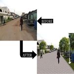
Projective drawings
- How would you like this case to change in the near future? (in 1-2 years)
- you may add a short explanation here
- And how could it look like in 10-15 years?
- you may add a short explanation here
- Projective Drawings
-
 projective drawing
 -
 projective drawing
 -
 projective drawing
 -
 projective drawing


Summary and conclusion
- 100 words approx.
Image Gallery
Please add further images/photos here
- Image Gallery
-
 your image text
 -
 your image text
 -
 your image text
 -
 your image text
 -
 your image text
 -
 your image text
 -
 your image text
 -
your image text


References
Aina T. ( 1990a ). The Urban Poor and the Commercialisation of Land in Nigeria. In: Baker J. Small town Africa: Studies in Reval - Urban Interaction. The Scandinavian Institute of African Studies, Uppsala. p.192-208. Aina, T. A. 1990. Health, Habitat and Underdevelopment in Nigeria with Special Reference to a Low Income Settlement in Metropolitan Lagos. International Institute for Environment and Development, London. Peil, M. 1991. Lagos: The City Is the People. Belhaven Press, London. Unicef ( 1995 ). Multiple Indicator Cluster Survey. Unicef, Federal Republic of Nigeria. Williams, F. A & Adejumo, T.A(2012) carbon sequestration as a tool for city greening- a case study of atunrase, a residential estate in metropolitan lagos. International climate change and population conference on africa, cc pop – ghana .
About categories: You can add more categories with this tag: "", add your categories