Green Infrastructure 2014 Working Group F - The Darsena Area
---> back to group page working group F
Implementing Green Infrastructure in the Darsena Area in Milan
| Name | Darsena Area | |||||||||||
| Country | Italy | |||||||||||
| City | Milan | |||||||||||
| Authors | Elena Staffoni | |||||||||||

| ||||||||||||
| {{#widget:GoogleMaps | width=300 | height=240 | lat=45.452537 | lng=9.177982 | zoom=15 | centermarker=yes | maptypecontrol=yes | overviewmapcontrol=yes | largemapcontrol=yes | scalecontrol=yes
}} | ||
Rationale: Why is this case interesting?
This case is very interesting for many reasons. The Darsena Area is still today (for different purpose compared to the past) largely frequented and loved from the people. The place is one of the few space in the city that have a potential to became a green oasis with its own ecosystem, its main strengths are the water basin (Darsena) and the waterways canals (Naviglio Grande and Naviglio Pavese). The water canal system has an intrinsic historic value for the city and for the inhabitants; through these waterways, from Candoglia (more than 100 Km away) in 1387 were carried the stone blocks necessary for the construction of the main cathedral of the city (the Duomo di Milano) for want of Galeazzo Visconti, the mayor of Milan. Today people come here both day and night time, for shopping, for restaurants and bars, or just to strive along the canals. Unfortunately, the Darsena has been unheeded for a long period of time. Despite years and years of discussions about the future of this piece of land, nothing has yet been turned into reality. Meanwhile, time has taken its toll on the Darsena and this urban void has not only turned into a quite hostile place, but it has also had a negative impact on its surroundings.
Author's perspective
The city of Milan has not so much green spaces compared to other European cities like London, Berlin or München, although the area of Milan (1.982 km2; about 3.869.000 inhabitants) represents one of the largest European metropolitan areas. Overall, green spaces in Milan covers a surface of 15.20 km2; the average amount of green spaces per capita is approximately 11.60 m2. The city has a medieval implant, so there is not so much space (nor for new infrastructure nor for new buildings) in the city centre. Redeveloping this place could represent an interesting and healthy way to improve the quality of life in the area, for inhabitants and tourists. I live in Milan since 3 years. I always wondered why this area was not taken into account, since the area is near the main city square (Piazza Duomo). I discovered that there is a social problem here, that go beyond the simple redevelopment of a city part. Once, the place was a kind of élite place, full of residences, small shops, art and artisan shops. Over time the place became the nucleus of the Milan night-life. The little, picturesque shops disappear, giving way to pubs and clubs. The frequenters, one time mainly family and old people, are now mainly young people ,especially coming from out of town. This situation create a kind of decline for the place. The inhabitants complain frequently for the noises at night and for the new-born parking problem. I think it will be interesting to see which solution will be found, taking into account that in 2015 there will be the EXPO in Milan.

Landscape and/or urban context of the Darsena Area
Biogeography
Milan normally experiences a Mediterranean climate with winters getting wet and cold, while summers are sweaty and hot. Metropolitan cities experience a 2-3 degree higher rise in temperature than in normality due to the urban heat island syndrome. In Milan people may experience an average temperature of +4 degree Celsius to +6 degree Celsius in January, which could heat up in between 15 to 28 degree Celsius in July. Snowfalls, a common happening in Milan, has decreased in the last 15-20 years due to the effects of Global Warming. The average snowfall during winter could pendulum between 30 to 40 cm. The greatest snowfall ever was recorded in January 1985 which was about 100 cm. The city’s climate which was mainly distinguished by its fog, due to the Po Basin effect has reduced considerably in the recent years due to lessened pollution and global warming. Milan is snuggled up in the lower plains of the Padana in the west-central Lombardy region of Italy. The rivers of Ticino, Po and Adda are an integral part of Milan’s province which is the first releases of the alpines. Milan occupied a total area of 181 sq.kms with a sea level rise of 122 m. The Milan city and metropolitan areas form the core industrial principal towns in Italy.
Cultural features


The Inner Circle of canals (Navigli) was a circular channel of about 6.5 km that, up to the 20's of the twentieth century, surrounded the center of Milan. The canal system was about 9 meters wide and was equipped with navigation locks and port areas of which the most famous was the Lake of Santo Stefano behind the Duomo (covered in 1857). Along the way there were 30 more little canals that were used to irrigate the orchards citizens and nurture important mills. The name of places today remember the ancient urban design; The street over the Santo Stefano lake is today called Via Laghetto (Lake Street) and the street over the mills' little canal is called Via Molino delle Armi (Mills Street). The route of the canals' ring resumed the ancient moat of medieval Milan, dug in 1167, and corresponded to the current streets Fatebenefratelli, Senato, San Damiano, Visconti Modrone , Francesco Sforza , Santa Sofia , Molino delle Armi, De Amicis , Carducci , Piazza Castello and via Pontaccio. At the end of the '300 the moat, expanded and made navigable, takes the name of "Cerchia Interna dei Navigli" (Inner Circle of Navigli) and it was used for the transport of marble Candoglia to the construction of the Duomo. In 1496 the ring of canals is connected to the Martesana Canal through the basins of Incoronata and S. Marco, making it the center of the system of the canals of the Lombardy Region, allowing continuous navigation from the Adda river to the Ticino river. This important function was to decline in 1929 when the Inner Circle was entirely covered.
Cultural curiosity
- The canals were a symbol of romance that the Futurists hated. Even today in Corso Venezia number 23 you can read a license plate that says: "That's the house where in 1905 Filippo Tommaso Marinetti founded the magazine Poetry. Hence the Futurist movement launched his challenge in the moonlight mirrored in the canal".
- The Navigli and the Darsena were the subject of many painting especially in 19th Century.
- In the middle of XV Century, Leonardo da Vinci realised a system of locks (devices for raising and lowering boats between stretches of water of different levels on river and canal waterways) for the Navigli.
Overall character
The history of Milan is closely connected with the creation of the Navigli, which pass as water network the whole city. Milan hasn’t a direct river connection. To ensure the water supply and to create transport routes, just in the antique ages was begun with the construction of artificial waterways, fed by the rivers of the hinterland (Ticino, Lambro, Adda). Thanks of the connection of artificial waterways from the rivers Ticino and Adda towards the Po River, Milan is practically connected to the Adriatic Sea. On the banks of the Naviglio formerly lived workers and artisans. Today, the area of the Naviglio could be a romantic area with artists' studios, original shops, romantic pubs, flea markets, and summer concerts but this atmosphere is unfortunately no more present.Outside Milan the water network serves for the irrigation of the fertile Padana fields Po Valley (the Europe’s largest plane extended from Milan to the hills). On the configuration of the locks of the channels already worked Leonardo da Vinci.

Naviglio Grande
The oldest canal was built in the years 1177-1257 and is fed by the river Ticino. The Naviglio Grande is about 50 km long and served as export and import route. For the transport of the enormous marble blocks from the reservoirs at Candoglia on Lake Maggiore, which were needed for the construction of the Milan Cathedral, the Naviglio was extended up to the cathedral. At the time of the construction of the cathedral, the waterway was conducted into the city center. The street name Via Laghetto (road by the pond) behind the cathedral testifies that. Today this part of the Naviglio is filled. Along the Naviglio Grande towards Ticino you will find the villages Cesano Boscone, Assago, Buccinasco, Corsico, Trezzano sul Naviglio, Gaggiano, Vermezzo und Abbiategrasso, that use the waters of the Naviglio for agriculture. Typical are the old houses and wash houses with wooden roofs and craftsman housesthat that remember past times. Today they house cafes and restaurants behind the typical facades and provide an ideal atmosphere for the evening meeting for the Milan's youth.
Naviglio Pavese
Naviglio Grande and Naviglio Pavese meet in the old harbor, the Darsena. Built in the 14th century, here is the connection between Naviglio Grande and the 35 km long Naviglio Pavese, which continues to flows about Binasco and Pavia to the river Po and the Adriatic Sea. An old sluice called "Conchetta" was set in motion again at the Naviglio Pavese. The special feature of the sluice is the hydraulic mechanism that Leonardo da Vinci invented to facilitate the opening of the locks. Thanks to a simulation, the invention of Leonardo was made visible again.
Darsena - the Harbor
The port Darsena was built in 1603 as a trade hub and is the main link between the Navigli. The Naviglio Grande is flowing into the Darsena while Naviglio Pavese and Ticinello are flowing out. Along the Darsena there is a weekly market held on Saturdays, where mainly second-hand goods and antiques are offered. The boat trip on the Canal Naviglio takes about one hour. It starts on the Naviglio Grande, pass the houses of the historic Milan and arrives the old bridges in the former harbor Darsena to continue the Naviglio Pavese to the lock where, thanks to the simulation, the inventions of Leonardo da Vinci are to be admired.
Naviglio della Martesana
The Naviglio della Martesana gets its water from the river Adda, which is powered from the side arm of Lake Como, the Lago di Lecco. The Naviglio della Martesana flow through the towns of Gorgonzola and Cernusco sul Naviglio and disappears in the center of Milan Garibaldi. Along the Naviglio della Martesana leads a popular cycle route from Milan to the river Adda. There the cycle way continues to north along the river Adda to Lecco.
History and dynamics
- History of the Navigli waterways in the Regional Scale
-
![XII Century [5]](/images/thumb/6/63/640px-Navigli_XII_secolo.png/372px-640px-Navigli_XII_secolo.png) XII Century [5]
XII Century [5] -
![XIII Century [6]](/images/thumb/e/ee/640px-Navigli_XIII_secolo.png/374px-640px-Navigli_XIII_secolo.png) XIII Century [6]
XIII Century [6] -
![1457 A.D. [7]](/images/thumb/c/c9/640px-Navigli_year_1457.png/380px-640px-Navigli_year_1457.png) 1457 A.D. [7]
1457 A.D. [7] -
![XVIII Century [8]](/images/thumb/e/e6/640px-Navigli_XVIII_secolo.png/382px-640px-Navigli_XVIII_secolo.png) XVIII Century [8]
XVIII Century [8] -
![XX Century [9]](/images/thumb/4/4f/Navigli_XX_secolo.png/381px-Navigli_XX_secolo.png) XX Century [9]
XX Century [9]
![XII Century [5]](/index.php?title=File:640px-Navigli_XII_secolo.png)
![XIII Century [6]](/index.php?title=File:640px-Navigli_XIII_secolo.png)
![1457 A.D. [7]](/index.php?title=File:640px-Navigli_year_1457.png)
![XVIII Century [8]](/index.php?title=File:640px-Navigli_XVIII_secolo.png)
![XX Century [9]](/index.php?title=File:Navigli_XX_secolo.png)
The city of Milan is at the center of a territory in between the rivers Ticino and Adda, large water ways that descend from the lakes Maggiore and Como. Unlike most thriving cities, Milan is not served by a major river. The construction of the artificial canal system started off with the outlining of the Naviglio Grande in 1179, linking Lake Maggiore of the Italian Alps with the region of Lombardia and the city of Milan via the Ticino River. Eventually, this complex water system was connected to the other major Northern Italian rivers Lambro, Adda, and the Po, which ultimately feeds into the Adriatic Sea. The Naviglio Grande was ingeniously developed to maximize natural rainfall, springs, and to drain marsh and swamp lands, as well as to irrigate former wasteland. The idea was also to connect the different cities that belonged to Milan, Abbiategrasso, Turbigo, Tornavento, Vizzola and others.The Naviglio Grande is often called 'il Ticinello', or the Little Ticino, because its water is drawn from the Ticino River. It connects Lake Maggiore, from the city of Sesto Calende, to the city of Milan. The watersystem became fully navigable in 1272 after an improvement of the canal making it wider and deeper. The Naviglio Grande made the movement of important items of commerce possible: grain, alt, wine, manufactured goods, coal, timber, livestock, cheese, hay, etc. The Naviglio Grande was used for troop and defense movement as well. The granite and marble used in the construction of the Dome of Milan was transported on the Naviglio Grande from the Alps. The canal did served as an irrigation system and as a mean of transportation, and also gave the population the possibility to fish and bathe in the water. The canal contributed to an improved health of the region, vegetation and crops in the newly irrigated farmland began to grow. The costruction of Naviglio grande was followed by the Naviglio Pavese and Naviglio Martesana and these three canals were all connected through Milan via the Fossa Interna, also known as the Inner Ring. The urban section of the Naviglio Martesana was covered over in the beginning of the 1930s, together with the entire Inner Ring. Commercial carrying continued on the Naviglio Grande, but the decline was steady and by the sixties it was over for good. During the 18th and 19th C impressive villas and palaces with lush gardens were built along the canals. The elite of Milan constructed summer houses here, most of which still stand today. oday one can embark on tours of the Naviglio from Milan. The activity is intense along the Naviglio, especially on weekends. Fishing, hiking, biking, and walking are popular treats this beautiful environment offers.
- Illustrations
-
![The Darsena empty basin[10]](/images/8/84/Empty_Darsena_basin.jpg) The Darsena empty basin[10]
The Darsena empty basin[10] -
![The Darsena in the 60s[11]](/images/thumb/5/5c/Historic_Darsena.jpg/350px-Historic_Darsena.jpg) The Darsena in the 60s[11]
The Darsena in the 60s[11] -
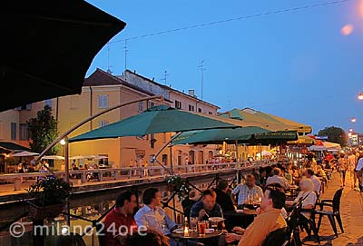
![People on the Naviglio enjoying an Aperitivo [12]](/images/thumb/a/a3/Summer_Aperitivo.jpg/350px-Summer_Aperitivo.jpg) People on the Naviglio enjoying an Aperitivo [12]
People on the Naviglio enjoying an Aperitivo [12]
![The Darsena empty basin[10]](/index.php?title=File:Empty_Darsena_basin.jpg)
![The Darsena in the 60s[11]](/index.php?title=File:Historic_Darsena.jpg)
![People on the Naviglio enjoying an Aperitivo [12]](/index.php?title=File:Summer_Aperitivo.jpg)
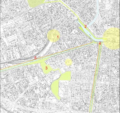
Analytical drawings
- Analytical Drawings
-
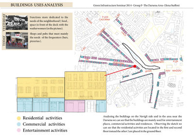 Building Uses Analysis
 -
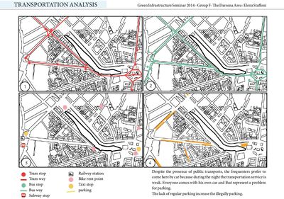 Transportation Analysis
 -
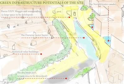 Green infrastructure POTENTIAL of the site


The POTENTIALS of the site are many. The area has some potentials physical ELEMENTS that are the water basin with its dried part to be redesigned, the water canals that connect the city with the surrounding region and the Piazzas, in particular the Piazza XIV Maggio, a space with historical value that needs to be redeveloped. an other important potential is the POSITION of the site, in the middel of the city. The place is very often frequented by people, especially during the night; the inhabitants love this place. The third potential is that the place is linked to the HISTORY because the Navigli and the Darsena in the past were fundamental for the transportation of people and goods; "The marble blocks were transported from Candoglia to Milan by means of the waterways from the river Toce to Lake Maggiore, along the Ticino and the Naviglio Grande canal and then into the city as far as the darsena [dock] of S. Eustorgio. Via the system of locks, created by Veneranda Fabbrica, the marble arrived at Laghetto, now Via Laghetto, only a few hundred metres from the Cathedral construction site" [13]. See the draw above to a visual idea.
The CONFLICTS of the site are mainly identifiable in Urban conflicts:
- Too many private auto traffic, even though the area is well served by transportation and the related "wild parking".
- Lack of space due to the presence of (historic) buildings that are to preserve.
- Scarcity of green areas due to the compact fabric of the city.
- Presence of archaeological ruins (founded during some excavation; the discovery stopped the redevelopment works).
and Social conflicts:
- Social and cultural conflict between frequenters of the pubs on the Navigli (mainly responsible of the illegally parking, of the night long noise and of the dirtiness). The place have lost its original character, the little artisan atelier are today displaced by bars and pubs.
- Economic and bureaucratic problem stopped many time the redevelopment works.
Green Infrastructure benefits for this site
Central to the concept of green infrastructure is that it provides a suite of benefits. They are environmental, economic and social. In my study case I individuate the most important that are the following ones:
- Environmental Benefits
- Green Infrastructure can preserve and restore natural ecosystems and provide habitats for native fauna and flora. The environmental benefits for the area are mainly connected to the waterways. The Darsena basin represent a ideal place where recreate a good ecosystem integrated with the city. We have the opportunity to obtain a multi-scale ecosystem network from the city to the near Region.
- It can mitigate climate change by reducing fossil fuel emissions from vehicles, lessening energy consumption by buildings and sequestering and storing carbon. It can improve the environment quality by removing harmful pollutants from the air and water. One of the main problem of the area is the traffic, which is strectly connected to the pollution. A new design in this sense could mitigate the pollution and create a more enjoyable environment for the residents and for the visitors. An other good intervention to do is the plantation of tree, that could purify the air. The Navigli could also became a new energy source, producing for example electricity with turbines.
- Economic Benefits
- Green Infrastructure can create job and business opportunities in fields such as landscape management, recreation and tourism. The visitors in the Darsena Area come mainly in the evening and at night. An improvement of the space could attract more people also during the day, growing the commerce and the activities related to that.
- It can increase property values, attracting residents and business to the community.
- It can reduce energy, healthcare, and grey infrastructure cost, making more funds available for other purposes.
- Social Benefits
- Green Infrastructure can promote healthy lifestyles by providing outdoor recreation opportunities and enabling people to walk or bike as part of their daily routines. Since I lived in the city for 3 years, I consider this aspect particularly important. The possibility to use the bike is today an essential city living goal. Unfortunately, even tough in Milan there are some cycle routes, that are insufficient and bad managed, often to small and directly in contact with the car street. In many main street there is no bicycle route so it's create a problem for the bikers themselves, that risk to be knocked over and also for the car that have to avoid them. The Darsena Area represent a perfect place where develop a route in this sense.
- It can improve environmental conditions (e.g., air and water quality) and their effects on public health.
- It can provide places for people to gather, socialize and build community spirit.
- It can improve the aesthetic quality of urban and suburban development.
- It can provide opportunities for public art and expression of cultural values. Recover the ancient atelier and little artisan shops tradition could recreate the original character of the place.
- It can yield locally produced resources (food, fiber and water). One time the women of the quarter washed their clothes directly in the Navigli. Today the solution appear of course extreme but the water of the Navigli could be used by the citizens for private personal scope like watering an orchard or a garden.

Connectivity

The Darsena Area has a great connectivity potential due mainly to the waterways, that flows through a large regional area. If the area is part of a physically connected system across the regional landscape, it could offer better services and benefits. Connecting the Area with the fields outsides the city, through the waterways environment by a corridor of native vegetation, could allow the wildlife movement between different habitat areas. Similarly a connection to other parks or site via regional hiking or biking trail serve more people than one surrounded by a local residential neighbourhood.
Potential for multifunctionality
The multifunctionality principle builds on the concept of the triple bottom line—the environmental, economic, and community benefits provided by green infrastructure. Also called ecosystem services, these benefits derive from the multiple and overlapping functions provided across the different systems—hydrology, transportation, energy, economy, and so on—that can intersect in green infrastructure. The multifunctionality principle calls on planners and designers to maximize value for the communities they serve by using green infrastructure to achieve seemingly disparate goals such as flood control, reduced dependence on imported energy, and improved public-health outcomes. The Darsena area is apparently identifiable as Local Area Scale because the elements involved are local parks, streets, city buildings, canals and a water basin. But the area is part of a more complex system, because the Navigli irrigate about 130 000 hectares of fields in the countryside around the city. This lead to consider a more extended area, in a Regional Scale. For this reason, when we create a new design for the site, we have to taking in account the different scale approach.


Acting at the Regional Scale level the multifunctionality principle that the site has to achieve are subdivided in:


RIVER STREAM CORRIDORS
- Maintaining a preservation of aquatic habitat
- Flood control
- Energy generation through tidal action or micro-turbines
GREENWAYS
- Attraction of residents and visitors
- Mitigation of noise and air pollution where adjoining roadways
- Improve public health
HIGHWAYS AND PARKWAYS
- Energy generation through wind-turbines and photovoltaic panels along medians and sound walls
Acting at the Local Scale level the multifunctionality principle that the site has to achieve are subdivided in:
URBAN PARKS
- CC2 sequestration through urban forestry
- Biodiversity enhancement through ecological restoration
WATERFRONTS
- Water quality and aquatic habitat
- Improvement through bio-engineered revetments and wetlands
BOULEVARDS
- Biodiversity enhancement through urban forestry
- Storm-water management through bio-retention
PLAZAS AND SQUARES
- Water retention and harvesting through rain gardens and cisterns
- Place for geothermal energy generation
- Community gathering places
Projective drawings
- Short Term Projection (1-2 Years)
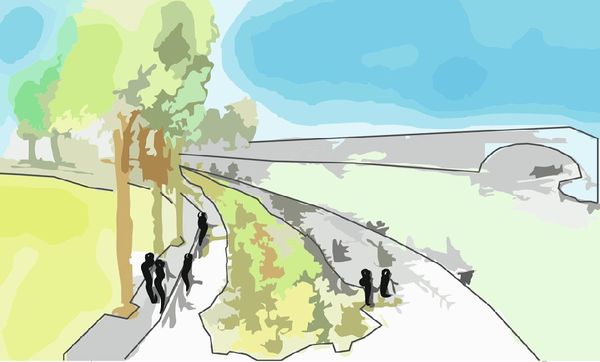
The project for the redevelopment of Navigli and the Darsena is very important for the city development, especially in occasion of the next EXPO in 2015 when the most important financial metropolis in Italy will be visited by millions of people from every country. This event will be the turning point for the city and the redevelopment of the area will be a part of it (at the moment, 26th November 2014, the area is still quite empty). The principal idea that I support is the re-opening of the Ticinello and other important water-courses that connected all the ancient Navigli with the Darsena. I imagine these waterways finally full of water where the boat can load and unload goods of every type and of course where it could be a new canal transportation system. This scenario is not as difficult as appear to realize because one time there was in the city a dense network of canals, today covered. The people could be carried every day through the city, maintaining as a focal junction point, one of the most important area in Milan, that is indeed the square of Porta Ticinese near the Darsena. In this way the traffic could be reduced. The new redevelopment should include also the creation of more pedestrian area and a cycle route, that at present is absolutely inappropriate. I see a very high potential in this area because there are a mix of elements like waterways, historical spaces and buildings and a water-basin that, if well designed and assembled, could generate a real enjoyable and people-oriented area in the city centre.
- Long Term Projection (10-15 Years)
I think that a long term development must be thought in a regional scale, taking into account the regional impact of the Navigli canals. The Navigli flow through an area of 1800 km2, with a development of 162 km of linear waterways involving 2,5 million of inhabitants. In the extended area there are 3 parks (Parco Lombardo della Valle del Ticino; Parco Agricolo Sud Milano; Parco Adda Nord). As a future development, I see the connection of this 3 parks as a great opportunity for many reasons, particularly in the field of environmental benefits and quality of life benefits. The goals of the new parks and open spaces plan are
- A system of well-maintained parks and recreation facilities that meets the needs of the residents of the Lombardy region.
- A network of open spaces and greenway corridors that protects significant natural resources.
- A parks and open spaces system that preserves and enhances visual quality, protects historic and archeological resources, and provides opportunities for education.
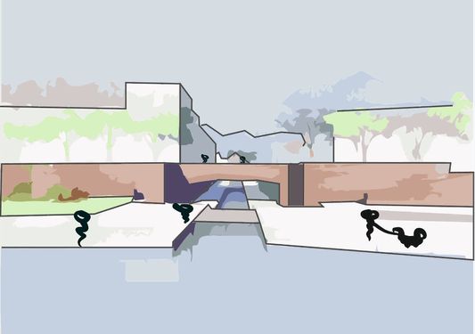
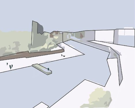
- Projective Drawings
-
 The Darsena Area, my vision 1
 -
 The Darsena Area, my vision 2
 -
 The Darsena Area, my vision 3
 -
 The Darsena Area, my vision 4 1. Redevelopment of the traffic situation in the main squares in the neighbourhoods (Piazza XIV Maggio, Porta Genova and Piazza Arcole). Development of pedestrian areas and improvements of the car and transportation connections, 2. Reopening of the old Navigli for recover the original character of the city, 3. Creation of a green park network through the city with new green areas and existent parks, 4. Creation of green corridors long the Navigli and creation of a regional scale green network by means of the Navigli waterways, 5. Creation of a bike road from the city to the fields.


Summary and conclusion
Planning and design a landscape is not easy; many professionals (planners, landscape architects, civil engineers, scientist and others) have to operate in collaboration to each others. The concept of landscape considered as a green infrastructure provides a great platform for the interaction of different sector to achieve larger societal goals. To successfully create green infrastructure at the landscape scale, these professions must use a conventional "mode of thinking" that could be synthesized in Multifunctionality, Connectivity, habitability, Resiliency, Identity and return of investment, taking in account also Environmental, Social and Economic Benefits. [20]
Image Gallery
- Image Gallery
-
![A. Inganni (1835) Milano, a City Water [21]](/images/thumb/9/94/Navigli_Paint.png/253px-Navigli_Paint.png) A. Inganni (1835) Milano, a City Water [21]
A. Inganni (1835) Milano, a City Water [21] -
![I.Karpoff, Naviglio d'Inverno [22]](/images/thumb/4/47/Artgate_Fondazione_Cariplo_-_Karpoff_Ivan%2C_Naviglio_d%27inverno.jpg/254px-Artgate_Fondazione_Cariplo_-_Karpoff_Ivan%2C_Naviglio_d%27inverno.jpg) I.Karpoff, Naviglio d'Inverno [22]
I.Karpoff, Naviglio d'Inverno [22] -
![Canals covering [23]](/images/thumb/9/9f/Navigli_copertura_01.jpg/253px-Navigli_copertura_01.jpg) Canals covering [23]
Canals covering [23] -
![Boat tour at the end of XIX Century [24]](/images/thumb/8/8f/1280px-Navigli_di_Milano_Naviglio_Grande03.jpg/270px-1280px-Navigli_di_Milano_Naviglio_Grande03.jpg) Boat tour at the end of XIX Century [24]
Boat tour at the end of XIX Century [24] -
![Summer Aperitivo on Navigli side [25]](/images/thumb/b/b2/Navigli-10.jpg/260px-Navigli-10.jpg) Summer Aperitivo on Navigli side [25]
Summer Aperitivo on Navigli side [25] -
![Naviglio Grande [26]](/images/thumb/a/a8/Naviglio-grande-canal.jpg/270px-Naviglio-grande-canal.jpg) Naviglio Grande [26]
Naviglio Grande [26] -
![Naviglio Grande evening [27]](/images/thumb/e/e3/Naviglio_Grande_am_Abend.jpg/270px-Naviglio_Grande_am_Abend.jpg) Naviglio Grande evening [27]
Naviglio Grande evening [27] -
![Graffiti on a building in the Darsena area [28]](/images/thumb/0/04/Index.jpeg/254px-Index.jpeg) Graffiti on a building in the Darsena area [28]
Graffiti on a building in the Darsena area [28] -
![sunday flea markt [29]](/images/thumb/a/a5/Mercatino.jpg/142px-Mercatino.jpg) sunday flea markt [29]
sunday flea markt [29] -
![Naviglio Martesana [30]](/images/thumb/d/d0/Martesana.jpeg/270px-Martesana.jpeg) Naviglio Martesana [30]
Naviglio Martesana [30] -
![The Naviglio Grande in Gaggiano town [31]](/images/thumb/7/70/Gaggiano.jpg/270px-Gaggiano.jpg) The Naviglio Grande in Gaggiano town [31]
The Naviglio Grande in Gaggiano town [31] -
![Swimming competition in Naviglio Grande [32]](/images/thumb/0/0b/Nuoto_triathlon_friesian_team_twitter-2.jpg/270px-Nuoto_triathlon_friesian_team_twitter-2.jpg) Swimming competition in Naviglio Grande [32]
Swimming competition in Naviglio Grande [32] -
![The oldest representation of the city (XIV Century) [33]](/images/thumb/3/39/Antica.jpg/190px-Antica.jpg) The oldest representation of the city (XIV Century) [33]
The oldest representation of the city (XIV Century) [33] -
![Green area system map of the Milan province [34]](/images/thumb/3/36/Provincia_plis_2006_p.gif/270px-Provincia_plis_2006_p.gif) Green area system map of the Milan province [34]
Green area system map of the Milan province [34] -
![Lombardy waterways [35]](/images/thumb/4/4a/LombardySimple.jpg/174px-LombardySimple.jpg) Lombardy waterways [35]
Lombardy waterways [35] -
![Waterways map for the EXPO 2015 [36]](/images/thumb/c/cb/Mappa_fluviale.jpg/270px-Mappa_fluviale.jpg) Waterways map for the EXPO 2015 [36]
Waterways map for the EXPO 2015 [36]
![A. Inganni (1835) Milano, a City Water [21]](/index.php?title=File:Navigli_Paint.png)
![I.Karpoff, Naviglio d'Inverno [22]](/index.php?title=File:Artgate_Fondazione_Cariplo_-_Karpoff_Ivan,_Naviglio_d%27inverno.jpg)
![Canals covering [23]](/index.php?title=File:Navigli_copertura_01.jpg)
![Boat tour at the end of XIX Century [24]](/index.php?title=File:1280px-Navigli_di_Milano_Naviglio_Grande03.jpg)
![Summer Aperitivo on Navigli side [25]](/index.php?title=File:Navigli-10.jpg)
![Naviglio Grande [26]](/index.php?title=File:Naviglio-grande-canal.jpg)
![Naviglio Grande evening [27]](/index.php?title=File:Naviglio_Grande_am_Abend.jpg)
![Graffiti on a building in the Darsena area [28]](/index.php?title=File:Index.jpeg)
![sunday flea markt [29]](/index.php?title=File:Mercatino.jpg)
![Naviglio Martesana [30]](/index.php?title=File:Martesana.jpeg)
![The Naviglio Grande in Gaggiano town [31]](/index.php?title=File:Gaggiano.jpg)
![Swimming competition in Naviglio Grande [32]](/index.php?title=File:Nuoto_triathlon_friesian_team_twitter-2.jpg)
![The oldest representation of the city (XIV Century) [33]](/index.php?title=File:Antica.jpg)
![Green area system map of the Milan province [34]](/index.php?title=File:Provincia_plis_2006_p.gif)
![Lombardy waterways [35]](/index.php?title=File:LombardySimple.jpg)
![Waterways map for the EXPO 2015 [36]](/index.php?title=File:Mappa_fluviale.jpg)
References
- ↑ <http://www.leonardoamilano.org/navigli.php>
- ↑ <https://www.google.it/search?q=darsena+anni+60&client=ubuntu&hs=fF9&channel=fs&source=lnms&tbm=isch&sa=X&ei=Vtl4VKLJB8XwaN-MgrAF&ved=0CAgQ_AUoAQ&biw=1600&bih=722#channel=fs&tbm=isch&q=darsena+1912&facrc=_&imgdii=_&imgrc=P0lwYvNUcr3PwM%253A%3BrHWt9XSeuLLMrM%3Bhttps%253A%252F%252Ffarm7.staticflickr.com%252F6035%252F6328442023_25e6631a10_m.jpg%3Bhttps%253A%252F%252Fwww.flickr.com%252Fphotos%252Fmilan_lera_insc%252F6927394602%252Fnearby%252F%253Fby%253Downer%2526taken%253Dalltime%2526sort%253Ddistance%2526show%253Ddetail%2526page%253D2%3B1000%3B843>
- ↑ <http://www.milanoneltempo.it/darsena.html>
- ↑ Re-elaborated version of a Google Maps image, Darsena Area.
- ↑ Map of artificial channels system (Navigli) in Milan and Pavia province during XII century. In blue artificial channels built for irrigation purpose, 1989, Regione Lombardia.
- ↑ Map of artificial channels system (Navigli) in Milan and Pavia province during XII century. In blue artificial channels built for irrigation purpose, 1989, Regione Lombardia.
- ↑ Map of artificial channels system (Navigli) in Milan and Pavia province during XII century. In blue artificial channels built for irrigation purpose, 1989, Regione Lombardia.
- ↑ Map of artificial channels system (Navigli) in Milan and Pavia province during XII century. In blue artificial channels built for irrigation purpose, 1989, Regione Lombardia.
- ↑ Map of artificial channels system (Navigli) in Milan and Pavia province during XII century. In blue artificial channels built for irrigation purpose, 1989, Regione Lombardia.
- ↑ La Repubblica-Milano.it<http://milano.repubblica.it/cronaca/2013/01/23/news/la_darsena_dice_addio_all_oasi_via_libera_al_taglio_degli_alberi-51088980/>.
- ↑ Navigli live -Milano <http://www.naviglilive.it/immagini%20associazione%20naviglilive/tavole%20darsena%20parcheggio/Nuova%20cartella/darsena%20milano%20navigli%2014.jpg>.
- ↑ Corriere della sera DOVE <http://viaggi.corriere.it/viaggi/weekend/citta/2013/luglio/italia-low-cost-nightlife.shtml>.
- ↑ <http://www.duomomilano.it/en/infopage/the-candoglia-quarries/47190562-c3f4-4196-8889-729729f4e54c/>
- ↑ Personal re-elaboration
- ↑ <http://it.wikipedia.org/wiki/Naviglio_Pavese#mediaviewer/File:Naviglio_pavese.jpg>
- ↑ <http://www.bed-breakfast-milano.net/sites/default/files/poi/83/Naviglio_Pavese.jpg>
- ↑ <http://earthtechling.com/wp-content/uploads/2012/03/Hydrovolts-Roza-Turbine_600.jpg>
- ↑ <http://media.02blog.it/P/Par/Parco_Nord.jpg>
- ↑ <http://alexbern.altervista.org/Italiano/foto.html>
- ↑ Green Infrastructure - A Landscape Approach - By David C. Rouse AICP, Ignacio F. Bunster-Ossa, APA Planning Advisory Service, 2013
- ↑ <https://www.google.it/search?q=a+inganni+navigli&client=ubuntu&hs=wi1&channel=fs&source=lnms&tbm=isch&sa=X&ei=rft1VOmnK4T6ywPcj4HgDQ&ved=0CAkQ_AUoAg&biw=1600&bih=686#facrc=_&imgdii=_&imgrc=dTjE9w3MoYgciM%253A%3BLw4SC5MBcYXegM%3Bhttp%253A%252F%252Fupload.wikimedia.org%252Fwikipedia%252Fcommons%252F4%252F43%252FAngelo_Inganni%252C_Veduta_del_Naviglio_e_della_chiesa_di_San_Marco_in_Milano.jpg%3Bhttp%253A%252F%252Fcommons.wikimedia.org%252Fwiki%252FFile%253AAngelo_Inganni%252C_Veduta_del_Naviglio_e_della_chiesa_di_San_Marco_in_Milano.jpg%3B746%3B600>
- ↑ <https://www.google.it/search?q=a+inganni+navigli&client=ubuntu&hs=wi1&channel=fs&source=lnms&tbm=isch&sa=X&ei=rft1VOmnK4T6ywPcj4HgDQ&ved=0CAkQ_AUoAg&biw=1600&bih=686#channel=fs&tbm=isch&q=karpoff+naviglio+d%27inverno&facrc=_&imgdii=_&imgrc=dUP8oWQoysgmAM%253A%3BzCh4B0hOaIaV5M%3Bhttp%253A%252F%252Fwww.edixxon.com%252Ffondcariplo%252Farte_900%252Fimg%252Fimg5%252F1158.jpg%3Bhttp%253A%252F%252Fwww.edixxon.com%252Ffondcariplo%252Farte_900%252F02_opere%252F1158.html%3B540%3B406>
- ↑ <https://www.google.it/search?q=navigli&client=ubuntu&hs=gng&channel=fs&source=lnms&tbm=isch&sa=X&ei=0Pd1VMrVFoWBywOt0IGABg&ved=0CAkQ_AUoAg&biw=1600&bih=686#channel=fs&tbm=isch&q=copertura+navigli&facrc=_&imgdii=_&imgrc=l-WVpS9EoNWM0M%253A%3Bsdu9dzaIoAqbLM%3Bhttp%253A%252F%252Fupload.wikimedia.org%252Fwikipedia%252Fit%252F9%252F9f%252FNavigli_copertura_01.jpg%3Bhttp%253A%252F%252Fit.wikipedia.org%252Fwiki%252FNavigli_%28Milano%29%3B800%3B600>
- ↑ <http://it.wikipedia.org/wiki/Naviglio_Grande#mediaviewer/File:Navigli_di_Milano_Naviglio_Grande03.jpg>
- ↑ <https://www.google.it/search?q=navigli&client=ubuntu&hs=gng&channel=fs&source=lnms&tbm=isch&sa=X&ei=0Pd1VMrVFoWBywOt0IGABg&ved=0CAkQ_AUoAg&biw=1600&bih=686#facrc=_&imgdii=_&imgrc=OudUeBqNmHvtaM%253A%3BgWQAXZ0nhs2b0M%3Bhttp%253A%252F%252Fd1xejl9xcsndu9.cloudfront.net%252Fwp-content%252Fuploads%252F2010%252F12%252Fnavigli-10.jpg%3Bhttp%253A%252F%252Fdevirnomadeviagem.blogspot.com%252F2012%252F09%252Fos-canais-de-milao-o-navigli.html%3B630%3B460>
- ↑ <http://www.essentialtravel.co.uk/magazine/24-hour-guides/milan.asp>
- ↑ <http://www.milano24ore.net/images/cityinfo/naviglio/Naviglio_Grande_am_Abend.jpg>
- ↑ <http://upload.wikimedia.org/wikipedia/commons/b/b3/4057_-_Milano_-_Graffiti_su_casa_occupata_alla_Darsena_-_Foto_Giovanni_Dall%27Orto,_7-July-2007.jpg>
- ↑ <https://www.flickr.com/photos/7501678@N03/2195499650/>
- ↑ <http://www.naviglilombardi.it/wp-content/uploads/2013/04/It_Martesana-624x398.jpg>
- ↑ <http://it.wikipedia.org/wiki/Naviglio_Grande#mediaviewer/File:Navigli_di_Milano_Naviglio_Grande_a_Gaggiano01.jpg>
- ↑ <http://www.milanotoday.it/sport/triathlon-milano-28-luglio-2013.html>
- ↑ <http://www.storiadimilano.it/citta/mappe/mappe.htm>
- ↑ <http://www.provincia.milano.it/export/sites/default/pianificazione_territoriale/img/provincia_plis_2006_p.gif>
- ↑ <https://www.google.it/search?q=navigli+natura+milano&client=ubuntu&hs=UzC&channel=fs&biw=1600&bih=722&source=lnms&tbm=isch&sa=X&ei=dRF5VJ7cMMPPaK_7gMgN&ved=0CAcQ_AUoAg#channel=fs&tbm=isch&q=navigli+lombardi&facrc=_&imgdii=_&imgrc=Bdmv2Bb-vW8AkM%253A%3Ba0iRmSPVIWT5YM%3Bhttp%253A%252F%252Fblog.inlandwaterwaysinternational.org%252Fwp-content%252Fuploads%252F2012%252F05%252FlombardySimple.jpg%3Bhttp%253A%252F%252Fblog.inlandwaterwaysinternational.org%252F%253Ftag%253Dnavigli-lombardi%3B550%3B599>
- ↑ <http://www.expo2015.org/it/cos-e/perche-milano-/vie-d-acqua>
About categories: You can add more categories with this tag: "", add your categories