Green Infrastructure 2014 Working Group A - Case Study 1
---> back to group page working group A
Ohrid Lake
| Name | Ohrid Lake | |||||||||||
| Country | Macedonia | |||||||||||
| City | Ohrid | |||||||||||
| Authors | Ivana Lilikj | |||||||||||

| ||||||||||||
| {{#widget:GoogleMaps | width=300 | height=240 | lat=41° 2' 50.1108 | lng=20° 42' 52.9992 | zoom=10 | centermarker=yes | maptypecontrol=yes | overviewmapcontrol=yes | largemapcontrol=yes | scalecontrol=yes
}} | ||
Rationale: Why is this case interesting?
Ohrid Lake is one of the oldest in Europe - around 1 million years, with endemic species that count 200. It is protected by UNESCO since 1979, and in 2014 was added to the UNESCO's World Network of Biosphere Reserves Ohrid-Prespa Transboundary Reserve between Albania and Macedonia, where the Lake resides in the mountainous region. The unique aquatic eco-system is endangered by the both countries with mechanical and chemical-industrial pollution brought by the numerous rivers and springs flowing into the Lake, illegal fishing, land consumption combined with low environmental awareness and careless attitude of the people. The selected area contains a space where springs enter the Lake, forming sort of canal where the fish called 'plasica'resides(very small endemic fish Alburnus alburnus alborella) combined with a wetlands-swamp-meadow system that is the 'lungs' of the lake containing large bio-diversity of flora and fauna. It is very endangered with the current(2014) urban plan that the Municipality gave, predicting hotel resorts and huge marina, to the already 25ha(out of which 15 under strong protection) of land crying for revitalization. There was a planned investment by German investor, but due to the recent changes, this has been canceled. The canal is used for recreation and as a temporary marina. This area is with a high frequency of tourist, many bars and beaches, thus vehicles and many water boats.
Author's perspective
I have Bachelor of Science in Architecture and currently enrolled to International Master of Landscape Architecture. I was born in Ohrid, and grew on the shore of the Ohrid Lake for 19 years. The Lake is an inevitable part of my life. I have always wanted to understand how this beautiful piece of nature operates, and at this point with the current challenges, maybe come up with something that can aid its existence. Perhaps come up with some new provocative solution for the people, and some eco-friendly solution for the bio-system. Lake Ohrid is one of the world’s natural reserves and is important to science because it has remained unchanged for a long time in the geological sense. This fact makes the lake an ideal laboratory for the discovery of many secrets concerning the appearance and development of life on Earth. Irresponsible behavior of land consumption driven only by financial interest and greed, could erase from this gem from our maps, that has been there with ages.
Landscape and/or urban context of your case
- Biogeography, cultural features, overall character, history and dynamics
- Illustrations: maps; sketches; short descriptive analyses
Size and placement
Lake Ohrid rightly deserves the name “Macedonia’s freshwater sea”. Not only for its warm water blue colour, which gains its intensity from the sky blue colour, but because of its size, this lake gives an impression of being a sea. It covers an area of 358 square kilometers and one gets an impression of being in front of a large bay of the sea as if a part had been uprooted of the sea’s breadth, and launched among high mountains 695 meters above sea level. On its northern shore the ancient city of Ohrid, rises above the lake like some colossal piece of scenery, located on a double hill with highest point at Samuel’s Fortress 800 m. above sea level.
The Lake is 30 km long, and its width varies from a maximum of 15 km, to an average of 11 km. Lake Ohrid has been found to be deepest 286 m., about 5 km from the shore, in the section between the fishing villages of Pestani and Trpejca. Its average depth is 151 m. The rare clarity of the water in Lake Ohrid whose translucency may reach down to depth of 22 meters, is due to numerous underwater springs all along the south and the east shores. Much of this water comes from Lake Prespa, which lies at a greater altitude and is also the outcome of a tectonic shift.
National park Right between ocean blue coloured waters of Lake Ohrid and Lake Prespa, mountain of Galicica is imposed with its towering limestone ridge. Due to its location, unusual natural beauty, scenery, aesthetic values, and exceptionally diverse and endemic flora and fauna, the Government of Republic of Macedonia has declared Galicica National Park in 1958. Galicica National Park encloses area of 25 000 ha. Lowest elevation in the park is Lake Ohrid (695m above sea level), next Lake Prespa (850m a.s.l.), and the highest point is the summit Magaro (2255m a.s.l.). South border of the National Park is also a national border with R. Albania, on the west the Park borders with the shoreline of Lake Ohrid. On the north, the border line passes through several landmarks, and connects both lakes. In addition to the extraordinary natural beauty and aesthetic values, Galicica is also a unique environment with well-preserved natural flora in several ecosystems. The flora in the National Park Galicica covers more than 800 species, among which there are numerous relict and endemic forms whose farthest limit of distribution is Mount Galicica itself.
Climate Owing of the influence of the Adriatic Sea, the Ohrid basin enjoys a modified Mediterranean varieties such as cypress, almond and fig trees. The whole valley and the surrounding mountains are situated in a basin where influences of several different climates those enjoyed by the Adriatic and Aegean coasts, the continental regions and the high mountains intermingle.
Flora and fauna With its unique flora and fauna the lake is one of the largest biological reserves in Europe. The earliest scientific studies, undertaken in the course of the 19th century, showed that, as one of the oldest lakes in the world, it has preserved primeval life - forms which no longer exist in other places or only exist as fossils. The fish in the lake are of particular significance. Lake Ohrid contains seventeen different species of fish belonging to the three groups: trout, white fish and eel.
Ten species of fish are endemic to Ohrid. The best - known are two kinds of trout, letnica (Salmo Letnica) and belvica(Acantholingua - Salmothymus ohridana), which are not to be found anywhere else. Besides eel, chub, carp and barbell there are also undermouth and moranec and a tiny fish called plasica, bleak (Alburnus alburnus alborella).
The endemic circular Ohrid sponge (ochridospongia rotunda) is one of the most interesting survivals in the lake. There are also other forms of sponge in the lake which are more widespread. The round Ohrid sponge however, has been compared by scientists only to sponges in the Lake of Tiberius in the Near East and in Lake Baikal. Tiberius and Baikal sponges are very ancient remains of a one - time living world in the Euro - Asian region which have been preserved up to the present day, each in its own lake habitat.
History and culture
In the treasury of European prehistory and history, Ohrid is a “live city” for 7500 years from which 2400 years is an urban capital on the coast of the magnificent Lake Ohrid. Continuous life has been present on the coast of the lake, where every epoch had its own particularities. Rapid urbanization in the recent 50 years, has brought a lot of concrete and 'contemporary' usage of land, that actually in this case meant drying wetlands to create soil for buildings. When it comes to the canal, it has been used much as recreational area in the last two decades, with sport fishing(when allowed depending from the very often changed legislation of fishing). Also, people parked their water boats, which with the years have became yachts thus bringing more pollution, unlike the older boats that used paddles to move . Also the residual old boats corrode there, likewise boat dump. The 'Biljana Springs' where the canal actually starts from are very often visited since there is a local legend connected to this. Biljana was a girl who used to wash the white sheets on the springs, but since she was sad cause the man she loved didn't love her she cried and made the canal. New bars and restaurants in the last 8 years have been open, and the area which was previously called 'Bafalo beach' surrounded with swamps because the people from the near villages from the mountain would go there to give water to their domestic animals, very non-prestigious area, is now core of commercial aggregation in terms of tourism.
- Illustrations
-
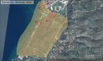
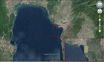 Geographical
 -
 Wider context
 -
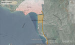
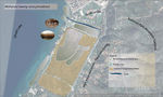
 Canal Green-Grey separator?
 -
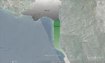
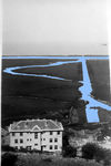
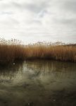
 Area of interest
 -
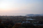
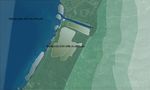
 Northwest view
 -
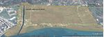
 Areal view southeast
 -
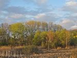 Trees in the wetlands
 -
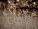
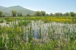 Blossoming reeds in swamp
 -
 The Hydro-biological Institute and the wetlands/canal(old)
 -
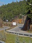
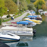 Pedestrian road next to canal


Analytical drawings
- Analytical Drawings
-
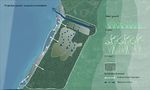
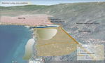 Placement
 -
 Circulation
 -
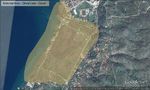
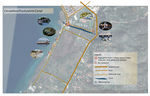
 Area prevalence
 -
 Topography


Green Infrastructure benefits for this site
Look again at the multiple benefits of green infrastructure - what could be achieved in your site and which are most relevant?
In the case of the wetlands and the canal, the most important benefit would be preserving and reintroducing ecological values of the land thus preservation of existing landscape. The revitalization of the bio-habitat and protection of the eco-system which is very fragile knowing the complexity of the food chain and habitat that swamps have, from micro to micro levels should be the core concern. Dragonflies, frogs, amphibians, birds, fish, other insects and animals together with many types of plants are forming habitat which also has a certain need of movement, which now is interrupted by asphalt roads and commercial activities. This leads that included the preservation of existing landscape, inevitable is the water management and connectivity of the ground/water, blue and green, water and soil.
Potential for multifunctionality
Green infrastructure has typically multiple functions. What could be achieved for your site in this respect?
Water management should be the biggest benefit as for the complexity of attributes the site has.
Multifunctional is the key word.
A very fragile area placed between the regional road and the Ohrid lake, in a center of touristic aggregation.
It has an economical potential for strategic investment/interpretation.
Gives space for innovation in terms of design and technologies.
Improvement integration of natural and urban (green/grey).
Connectivity/circulation by diverse cycle routes, pedestrian and green bridges.
Irrigation systems for agricultural activities and flood prevention(the level of the lake sometimes rises so high) at very risky levels.
Re-naturalization of habitat by linking the ladscape with ecological values would abort further fragmentation of the land and provide new connectivity.
Projective drawings
- How would you like this case to change in the near future? (in 1-2 years)*
In 1-2 years I believe this can be done:
-cleaning the mechanical waste from the canal and the wetlands
-removing all the boats from the canal
-removing the present infrastructure
-plantations of new reed and other flora
- And how could it look like in 10-15 years?*
-new plants will going to be grown much in height
-the reed from the lake and on the soil would reconnect
-new spontaneous water canals into the wetlands from the canal, thus better connectivity with the lake
-increased number of fauna and its movement
-big interest of visitors to the rehabilitated zone that would offer mupliply activities and qualities of function
- Projective Drawings
-
 Projection of wetlands restoring
 -
 Sections legend
 -
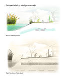 Section AA
 -
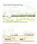 Section BB
 -
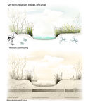 Section CC
 -
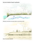 Section DD


Summary and conclusion
- The vision for my site is to restore the natural habitat, so that spontaneously and naturally flora and fauna movement would be provided. To support the eco-system which is in unbalanced by higher restrictions in legislation also. To propose new connectivity and accessibility which will be not so invasive like the present.. .All of this preserving the strong touristic and leisure potentials. Priority is the restoration of the swamp, but certainly enhancing the potentials for social and economical benefits.
Image Gallery
- Image Gallery
-
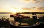
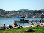
 Vista
Vista -
 Vista reed lake promenade
 -
 Regional road - only along the lake to Albania
 -
 Bar Cuba Libre Beach
 -
 Kadmo Bar Beach
 -
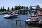 The only bridge over the canal
 -
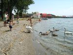 Swans on the beach
 -
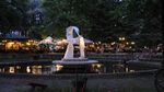 Restaurant at Biljana's spring
 -
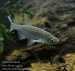 Alburnus


References
- [1]Fish species
[2]Lake age publication
http://www.balkanology.com/macedonia/article_ohrid.html
http://www.exploringmacedonia.com/ohrid.nspx
http://whc.unesco.org/en/list/99
http://www.macedonia.co.uk/client/index1.aspx?page=376
http://www.macedoniancities.com/history/ohrid.asp
About categories: You can add more categories with this tag: "", add your categories