Green Infrastructure 2014 Group A - Case Study 4
---> back to group page working group A
Reviving the old valley of jerash
| Name | Old Valley of Jerash | |||||||||||
| Country | Jordan | |||||||||||
| City | Jerash | |||||||||||
| Authors | Ibrahim Almardini | |||||||||||

| ||||||||||||
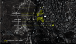
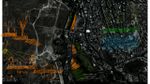
| {{#widget:GoogleMaps | width=300 | height=240 | lat=32.279128 | lng=35.893838 | zoom=15 | centermarker=yes | maptypecontrol=yes | overviewmapcontrol=yes | largemapcontrol=yes | scalecontrol=yes
}} | ||
Rationale: Why is this case interesting?
Please explain in short why this site has green infrastructure potential and what makes it special (150 words approx)
Jerash was considered one of the Decapolis union back in roman times and gave it an important place in their eyes. Thus, major developments had happened back then considering the urban planning of the city. This old valley was the main spine that distributed water and ignited the roman baths. Up until the early 90s, that valley was a close refuge for the citizens of small Jerash to have picnics and some quality time. Nowadays, the municipality does not have not the experience nor the money to take this aspect into consideration. Therefore, it is dying day by day; the river only streams in the spring, the roman baths are still in ruins and people trash the open space that is near. Although this part of the historical site very much out of governmental thinking, it has the potential of helping in many ways.
Author's perspective
what is your professional/educational background and your relation to the site?
I graduated with a bachelor’s degree in architecture this year and I’ve been living in Jerash my whole life. Even before I was interested in architecture, the historical city was and still is the background for any picture I have and it pains me to see the potential but not the care. This space is the only space we (as citizens of Jerash) have to hang out with either with family or with friends, which has a walk able distance.
Landscape and/or urban context of your case
- Biogeography, cultural features, overall character, history and dynamics
- Illustrations: maps; sketches; short descriptive analyses
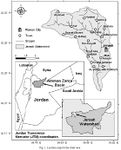
Jerash, the Gerasa of Antiquity (Ancient Greek: Γέρασα, Hebrew: גַ'רַש), is the capital and largest city of Jerash Governorate (محافظة جرش), which is situated in the north of Jordan, 48 kilometres (30 mi) north of the capital Amman towards Syria.
History of the place
Jerash was inhabited more than 2000 BC ago, with even some recent excavations saying people were here even since the Bronze Age. However, a strong earthquake in 749 AD destroyed large parts of Jerash, while subsequent earthquakes along with the wars and turmoil contributed to additional destruction. It was considered one of the 10 cities of the Decapolis states, so it had a major attention from romans back then which made it a safe to settle in. and so it reached about 800, 00 square meters within its walls. Its destruction and ruins remained buried in the soil for hundreds of years until they were discovered by German Orientalist Ulrich Jasper Seetzen in 1806.[4] He began excavation and a return to life of the current Jerash by inhabitants of older villages. 70 years later, this was followed by the Muslim community, Circassians, who immigrated to Jordan from the Caucasus in 1878 after the Ottoman-Russian war. Subsequently a large community of people from Syria came to the area at the beginning of the 20th century followed by another wave of Palestinians in both 1967 and 1948 wars. Modern Jerash Nowadays, Jerash considered a second place in Jordan’s tourism sites after famous Petra; it is even goes by the name Pompeii of the east because of the amount of the old city is preserved on. In general, it lives on the tourism industry as a major contributor to the local economy. With the three biggest cities being around it (Irbid, Zarqa and Amman), this slows it’s growing down as the investments go to those cities. And in the end of July, “Jerash festival “comes to life for three weeks with people coming from all around the world either to perform of to be amused by the performances. It is a peaceful place to rest the mind; with restaurants, clear gasps of air and the country side of Debbien forest, you can visit or live in Jerash and guarantee yourself with long term quietness.
Biogeography
Jerash Governorate's geographical features vary from cold mountains to fertile valleys from 250 to 300 metres (820 to 980 ft) even reaches the 600m point above sea level, it is suitable for growing a wide variety of crops. It is located in what’s known for “the green valley”, it has a number of about 1.25 million olive trees with a number of other trees and crops. The name itself means “a place with a high density of trees”, a name the old Arab\ Semitic used to use.
(Further historical background can be found in the references)
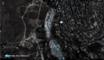
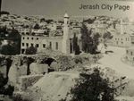
The river
Since the old ages, this river of Jerash had every potential to keep being the water spine of Jerash; you can drink from it or use it as agricultural supply. As seen in the old picture that was taken in 1920, the valley was much more livable and supported much more farms than it does now. Due to lack of management, the valley now flourishes in the spring and dies in the summer. The river springs from “Al-Qairawan” and continues to run until it meets with another coming from Al-Zarqa city, which then pours in the “King Talal” embank. On the east of the river, the old roman baths are located and the Main transport-station was beside them before moving to another place and the government decided to design a public plaza instead. But the low recognition and the bad inner\cultural values from the citizens for the efforts made, killed the very essence for designing it and it became hard to use because of the amounts of trash and odors. The rapid expanding of population with no planning, the industrial pollution, the wild life irrational hunting and habitat loss due to either non-structured planning for expansion or not authorized tree cutting have made Wild life in a decreasing state. What was known as “the land of milk and honey” is now suffering from deforestation and desertification.
Eco systems\natural areas near the vicinity
A few kilometers away from Jerash, Debbien forest reserve is located. It is now one of the few remaining self-sustaining forests of Aleppo pines in Jordan. It has been officially reserved by the government and the famous “Dubai-capital” group is building a camping site\hotel there to that over-look the whole space. On the other hand, there is the Zarqa River that is polluted by industrial plants located on it. In this river, you can find some small life signs like fishes and frogs. Because it’s contaminated, you can only plant trees around it and not vegetables.
Agriculture
All sorts of agriculture that depends on medium heat levels are being practiced in Jerash. Whether it’s vegetables, landscape (decorative) plants, productive seasonal trees, or even ever-green ones, you can always find someone who is working on them. Animals are also being used around here, but not so much in modern ways; people still have groups of goats, cows and sheep that they raise.
- Illustrations
-
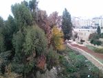
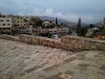
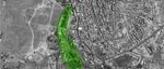 The valley now
 -
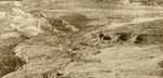
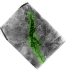 The valley from 1920
 -
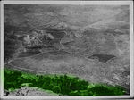 Old valley
 -
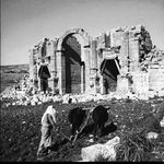
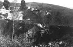 The roman brige before
 -
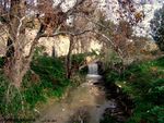 The little stream left
 -
 a lot of trash with no water
 -
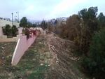
 Old transport station
 -
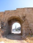
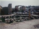
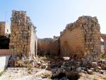 the ruins that still stand from the roman baths
 -
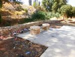 The trashed new spaces


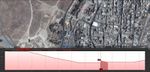
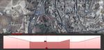
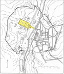
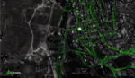
Analytical drawings
- Please use analytical drawing for visualising the conflicts/potentials of your site
- Analytical Drawings
-
-
-
-
-
-
-
-
-
-
-
your drawing


Green Infrastructure benefits for this site
Look again at the multiple benefits of green infrastructure - what could be achieved in your site and which are most relevant?
The most Relevant benefit and because the city is still not so stretched and most people still work in agriculture, we can introduce the green infrastructure strategies easily and let it integrate with the daily normal life. Thus, help in water management solutions, improve air quality and since Jordan is in an area well known for its summer heat, it will reduce the heat of the atmosphere. Also, Jerash is well known for its contribution in the fruit and vegetables basket of Jordan. A green infrastructure that reflects the green spirit of Jerash can only add a point on the chart of strategic master planning.
Potential for multifunctionality
Green infrastructure has typically multiple functions. What could be achieved for your site in this respect?
If it’s going to be revived, it can be good to generate some electricity and help in growing much bigger agricultural coverage than now. You can invest in some entertainment locations; the roman baths and some new well designed routes can be of such help. With this, more places for people as well to enjoy and communicate with this forgotten nature. Therefore, its great historical values of different ages will be seen and lived by green routes through either productive zones or just eco-friendly ones.
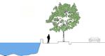
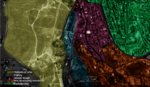
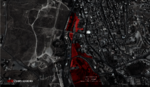
Projective drawings
- How would you like this case to change in the near future? (in 1-2 years)
- you may add a short explanation here
- And how could it look like in 10-15 years?
- you may add a short explanation here
- Projective Drawings
-
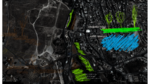 perspective on the short term with some imagined sections
 -
 perspective on the long term with some imagined sections
 -
 the whole route is needed to be included in the study
 -
projective drawing


Summary and conclusion
The best way to present our designs to the public, is by making them interactive and integrated into people's lives so much, that they wouldn't believe how much life was hard before these designs. This case is so important because whether jerash's public know it or not, it had a massive effect over their lives. It can help it the very most important matter that they always complain about. On the other hand, it can also help a part of them to re-connect with long forgotten nature by creating peaceful, sustainable and productive environment.
Some of the older generation still remember that legendary valley from their youth and tell us stories that we consider myths.... So why won't we just bring those myths back!!
Image Gallery
Please add further images/photos here
- Image Gallery
-
 A near parking
 -
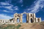
 hadrian
 -
-
-
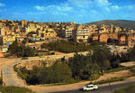
 view to the valley
 -
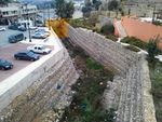 existing sewage system
 -
-
 existing roman bridge
 -
-


References
- please add your references here
http://www.marhabavip.com/a_jordan_jarash.htm
http://www.jerash.gov.jo/aboutus1.aspx
http://www.kinghussein.gov.jo/tourism3.html
http://en.wikipedia.org/wiki/Jerash
Google Earth
جرش ما بين الماضي و الحاضرfacebook page:
About categories: You can add more categories with this tag: "", add your categories