Great War Island
A natural river island located in the central city zone of Belgrade
| Name | Great War Island | |
| Place | Belgrade | |
| Country | Serbia | |
| Topic | Nature conservation | |
| Author(s) | Nada Jadzic,Mirjana Jovanovic,Jovana Kovacevic, Lena Madzarevic and Daliborka Stojakovic | |
| Completion | 2002 | |
| Client | Government | |
| Project costs | Please enter the costs (if known) | |

| ||
| <googlemap version="0.9" lat="44.829213" lon="20.433025" type="satellite" zoom="13" width="300" height="250">
</googlemap> | ||
Rationale: Why is this case study interesting?
- The project "Great War Island" is a proposition for protecting the Great and Small War Island on the river Danube,in Belgrade as the V category of IUCN categorization. Considering that this area is localized in the heart of the city center zone, it is a subject of interest for many different user groups. The final goal of this case study is to stop further degradation and preservation of native ecosystems of wetlands that are habitats for many rare and jeopardized species of ornithofauna.
- This area is very interesting from many different , scientific and owners approaches: urbanistic, artistic, esthetic, ecological, economical,political,touristic, biological....But most of all this case study shows how a legal protection is applied to conserve a very fragile natural ecosystem in the city tissue and how this case can be used as a recommendation for the similar cases in urban environment throughout planning .
Author's perspective
- What theoretical or professional perspective do you bring to the case study?
The perspective that we bring to this case study is in great measure based on nature protection. Our educational background is at the most based on ecological, protective aspect, but to complete the seminar tasks, we had to observe this case study from planning and urbanistic points of view. The proposal for protecting the Great and Small War Island is based on important results that influenced and encouraged the legal protection of the island, and this is a very rare example of exhaustive protection in our country, so we generally considered this proposal from a positive perspective.
Landscape and/or urban context
http://www.strugar.co.yu/slike2/0278.jpg
Great War Island gained its militant name because throughout the history Great War Island was an important strategic point either for the conquest or the defense of Belgrade. Both, Turkish (1521.) and Austria-Hungarian (1915.) forces, used the island to launch their attacks against Belgrade. The island is located at the mouth of the Sava river into the Danube, in the Danube's widening, as a product of alluvial accumulation, which is caused by slowing down the river flow. Great War Island is generally triangularly shaped and covers an area of 2.11 km². It is low (the average altitude is 72m) , for the most part marshy and often flooded by the Danube. In recent years only the coastal areas of island were flooded. The process of sedimentation is not completed and the shape of the island is still changing. So there is possibility of making a land connection to the bank of the Danube, because the island is relatively close to the banks, at the closest it is just 200 meters. On the south, halfway between the Great War Island and the city of Belgrade is the remnant of previously larger Little War Island. One of Belgrade's beaches, Lido, is located on the northern tip of the island.
The main physical feature on the island is the canal of Veliki Galijaš. In time, the canal was cut off from the Danube and effectively turned into a lake, with an area of 0.24 km² and the major natural bird and fish spawning area on the island. During the droughty years the lake drains out completely causing damage to the closed eco-system centered around it. In 2007 the lake was connected to the Danube by the bioremediation. [1].
There are three zones of protection on the island:
- Special areas – Zone of nature protection
- Developed areas – Zone of recreation
- General areas – Zone of turism
Currently Zone of nature protection is habitat for 196 bird species, many of which are endangered. Protected bird species:
1.Species protected by Bone convention:
- Anas querquedula
- Aythia nyroca
- Anas plathyrhynehos
2. Species protected by Bern convention:
- Saxicola torquata
- Upopa epops
- Motacilla alba
- Motacilla flava
- Erithacus rubecula
- communis
- Sylvia atricapilla
- Oriolus oriolus
- Carduelis carduelis
- Tachybaptus ruficollis
- Nycticorax nycticorax
- Ardeola ralloide
- Egretta garzetta
- Turuds merula
- Parus coerleus
- Ardea purpurea
- Crex crex
Plant life on the island includes the typical marshy flora. Dominant association is Salicetum albae. The typical vegetation is degraded by invasive introduced species (Amorpha fruticosa, Polygonum lapathifolium, Echinocytis lobata). There are some rare conifers on island (Taxodium distichum), which are also introduced.
Though officially uninhabited, almost a dozen of people live in small shacks in the island's interior, called urban garden colonies. They are mostly retirees who move to the island during the warm season and maintain their vegetable gardens, while in the winter they return to Belgrade. This is the one of main problems, because they are in Developed area and that is against the law. Whole situation is very complicated, because they came on the island many years before it was protected by government. Also, the major problem is bulky junk, which is deposed by the both rivers on the banks of the island. Process can not be controlled and it is a source of great pollution on the island.
Cultural/social/political context
According to spatial and urban plans, The Great and Small War Islands are mainly used for its flora, recreation and protection of a great source of drinking water, which puts the proposal to make them protected areas in accordance with the aforementioned advantages. According to the new master plan of Belgrade, The Graeat War Island is categorized as an area of outstanding features. Nowadays, the protection of the Danube, the river which connects the East and the West, has become the object of strong international cooperation of the European countries, which led to common international conservation and development campaigns which are supported by the United Nations, the World Bank, The European Union and other international organizations. The First World War was followed by hectic urban sprawl of Belgrade and Zemun. Therefore, the development of new areas, setting up new businesses and inland navigation has changed the attitude towards The Great War Island. Small islands in the Danube lost their strategic and military importance and were used only for agricultural purposes and its forests. The homeless also inhabited the islands. People in Belgrade, especially those who live in Zemun and are sentimentally very attached to this area, liken The Great War Island to the Lido beach. Between the two wars it became the favorite place to gather, for those who live in Zemun but also for some Belgraders, who have been using more the beach which has a view of Belgrade.
History
The idea of the conservation and special status of The Great War Island, primarily as an outstanding area, originated long time ago. At first, it was mostly about the island as a place to go swimming and do water sports in natural surroundings. Such perception of the island doesn’t allow turning this island into an urban area and opposes to building architecture, which would dominate the island. At the Institute for Planning and Development of Belgrade, they came up with an idea to turn the island into a source of drinking water in 1984,and this was followed by thorough research and scientific papers, which led to discussing other aspects of how the island can be used and its preservation. The proposal that was put forward at the city assembly of Zemun in 1984 was declined, but was supported at many events organized to discuss the topic. The issues that brought about this topic again were:
- International activities
- A new draft of master plan of Belgrade
- Uncontrolled usage of the island
- The interest of potential investors
In accordance with the regulations related to environmental conservation, The Nature Protection Institute of Serbia has issued a decree on preparatory protection of The Graeat War Island, which enabled a thorough proposal with valid arguments, and prevention of the degradation of this particular area and its valuable natural habitats. This decree and the research that followed with the aim of deciding on the optimal framework of usage and evaluation of very complex functions of this area, led to a proposal of the case study related to the preservation of The Graeat and Small War Islands as “areas of outstanding features”
Spatial analysis of area/project/plan


The Danube in the north, the Sava in the east, and small backwater channel of the Danube, called the Dunavac surround The Graeat War Island in the south and west. The shape of The Graeat War Island has changed dramatically at the mouth of the Sava in the lower part of the Danube’s flow. The average altitude of the ground is 72,0 meters, and the whole area leans towards the flow of the Danube, that is to say, towards the east. It has been estimated that there is 880 liters of drinking water, which makes the island a potential source of drinking water but also imposes a threat to the preservation of natural ecosystem.
The former canal is one of the major physical features on the island. In time, the canal was cut off from the Danube and effectively turned into a lake, with an area of 0.24 km² and became the major natural bird and fish spawning area on the island. However, during the droughty years the lake drains out completely causing damage to the closed eco-system centered around it. In August 2007 a digging of a 300 meter-long canal, which would reconnect Veliki Galijaš with the Danube, also began to prevent the seasonal drying of the lake. After it was completed, fish from the Sava began swimming into the Veliki Galijaš.
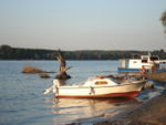
The Graeat War Island is a protected natural property according to the master plan of Belgrade; it is not listed as a building-site, except for one lot. Therefore, we can say that there are barely any parts of the island on which something has been built. Only 30 percent of the island has been used effectively. This percentage includes the beach and agricultural land, which has been leased. This is not a constant figure. In the summer, there are about 2000 bathers at the Lido beach and the islands are either accessed by many different kinds of boats or they sail around them. Recently, a lot of summer scout camps have been organized on the island and the scouts are usually put up in temporary lodgings. The islands are accessible only by boats. Occasionally, a pontoon bridge is installed, and it connects the Zemun quay with the beach, but there is no scheduled trip to and from the islands. You can go round the island only on foot but the biggest part of the island is inaccessible due to its wild flora.[1]
Core Questions Working Group Nature Conservation / Water
What is the role of user groups?

We can determinate user influence as the most important, because it changes the island in general. Considering the fact that all users aren`t equal in the way that they make use of the island benefits, their influence can be seen as direct and indirect.
- recreation (direct - junk, great pressure on protected zone, noise, light....)
- garden colonies ( direct - degradation, pollution, pressure on protected zone...)
- eco camp (indirect - education, promotion of health environment, cleaning the bulky junk on the Island....)
- public greenery service (direct - protection,conservation,improvement..)
- scientific teams (indirect- nature study,protection...)
What is the role of the city?

City is the frame of the island, so therefore it leaves a big mark on the island. Considering the fact that the island represents a great natural resource and that the city structure is everything but natural, the role of this gigantic concrete living machine is mostly in conjunction with pollution, noise, light, bulky junk, drainage.. But also we must take into consideration that city represent one great political and directional tool that has protected the island and is trying to conserve and improve this natural habitat to the best possible level.
How do urban and natural structures interact?

Great War Island is very unique element in city panorama and gives exceptional visual effect. Interaction between urban structures and natural structures are established in many mutual affects (either there are positive or negative affect). The Island is the great part of a city green belt, it improves city`s microclimate and creates satisfying conditions for living in urban habitat. Also the Island increases biodiversity in uniform urban structures. From social point of view, the Island is a place for recreation, education and can become a very interesting tourist attraction. On the one hand, city is a big source of pollution and has significant influence on degradation of the Island, and on the other hand the island is a very fragile creature in urban structure and it couldn`t survive without legal protection that is provided only by city government.
What is the role of water?

Water is the main creator of the island, it’s flora and fauna, attraction for recreation and garden colonies, humid micro climate.. Water brings lots of pollutants to the island banks, but it also cleans it, so this dynamic element is both creator and destroyer.
What is the evolution of the urban relation between humans and nature?
2002 from Government
The project "Great War Island" is a proposal for protecting the Great and Small War Island on the river Danube,in Belgrade as the V category of IUCN categorization. That this area is localized in the heart of the city center zone. But most of all this case study shows how a legal protection is applied to conserve a very fragile natural ecosystem in the city tissue and how this case can be used as a recommendation for the similar cases in urban environment throughout planning . There are three zones of protection on the island:
Special areas – Zone of nature protection Developed areas – Zone of recreation General areas – Zone of turism
City is the frame of the island, so therefore it leaves a big mark on the island. Considering the fact that the island represents a great natural resource and that the city structure is everything but natural, the role of this gigantic concrete living machine is mostly in conjunction with pollution, noise, light, bulky junk, drainage.. But also we must take into consideration that city represent one great political and directional tool that has protected the island and is trying to conserve and improve this natural habitat to the best possible level.
Analysis of program/function
- What are the main functional characteristics?
The functional model of spatial planning depends on the protection regime, measures and activities, which have been taken in order to keep and improve natural and cultural characteristics–regional and local development programs. The main functional characteristics are:
- protection and improvement of existing ecosystems
- tourism
- recreation
- education
The main functional characteristics have been determined according to the same criteria:
- protection of specific natural values, it refers to the areas that are important for scientific, cultural, educational and recreational purpose.
- protection of biodiversity, it refers to flora and fauna.
- protection and sustainable use of resources (water, land under cultivation, ichthiofauna, forests, game).
- specific goals, it refers to the protection of areas of specific interest
How have they been expressed or incorporated? The program has been implemented through zoning in accordance with
- the use of land
- protection regimes[2]
Analysis of design/planning process
- How was the area/project/plan formulated and implemented?
Plan proposal prescribes guidelines for protection, present spatial use and legal base for future drafting about the Great War Island`s area, and also binding environmental assessment for all interventions and actions. This plan proposal is implemented trough:
- Zoning and demarcation according to legal acts
- Lining out main and boundary pathways across the area
- Assigning prohibition of: hunting, fishing and improperly passing.
On and around entire Island, research work and waterway traffic are allowed. Besides, the international documents related to Ramsar Convention on Wetlands and The Danube River Protecton Convention, are applied.
Zoning

I Zone: Nature protection zone (Special areas), First degree of protection regime
- protection of flora and fauna, and their habitats
- prohibition of building and meliorate work, unless their function is protection
- prohibition of public transport and communal installations.
II Zone: Recreational zone (Developed areas), Second degree of protection regime
- different types of recreation are allowed
- allowed agriculture, until the complete plan implementation
- allowed communal installations
III Zone: Tourist zone (General areas), Third degree of protection regime
- improvement of tourist supply
- allowed communal installations[2]
- Were there any important consultations/collaborations?
The Nature Protection Institute (in Serbian) contrived a proposition of plan, with contribution of the Institute for Urbanism of Belgrade, Cultural Heritage Preservation Institute of Belgrade, Faculty of Forestry (in Serbian) - Belgrade, Department of environmental protection and Municipality of Zemun (in Serbian).
Analysis of use/users
- How is the area/project/plan used and by whom?
- Is the use changing? Are there any issues?
Illustration: Map/diagram/sketches photos and background notes
Future development directions
- How is the area/project/plan evolving?
- Are there any future goals?
Future goals for this particular case study are: Translation of this proposal for protection of the Great War Island to a legally valid document –law. Although, the City authorities did declare Great War Island as protected area, the whole plan was not officially formulated as a legal document.
- Providing a financial support for the conservation and protection of Island.
- Protection and melioration of natural characteristics of Great War Island.
- Creation, ratification and application of programs and plan documents ,with expertise and social validation.
- Coordinated teamwork of all relevant subjects (city authorities, legal trustee of the Island, all groups of users, institutes for nature and heritage conservation…)
- Development of sustainable tourism.
- Sustainable management on Island’s resources.
- Greater involvement of local community and NGO sector in decision making
As guidance for the all future planers we can quote M. Bobic: “ ..If Belgrade is seeking it's way to the water, then the Island is definitely not that way. Belgrade is richer in water than rarely any other European city, and the aspects of water - use are very diverse...That is Belgrade's priceless value. Belgrade also has enough space for degradation and recuperation... then why would we let the Great War Island to be unreasonably and rashly squandered, no matter how good the argumentation is? The only meaningful thing that could be done with the Island, if anything has to be done, is to leave it, just the way it is – inaccessible and untouchable, oases that fascinate both planers and developers.”[3]
Peer reviews or critique
- Has the area/ project/plan been reviewed by academic or professional reviewers?
The plan proposal went through parliament procedure so that The Nature Protection Institute could contrive the new elaborate based on this proposal. This elaborate has the significance of a legal act and the area was protected adjusting to this act.
- What were their main evaluations?
The plan proposal war reviewed by admistration officers and experts, along with by their suggestions and eventually the approval. These reviews are in governmental archives and The Nature Protection Institute, but unfortunately it`s very difficult to reach them.
Points of success and limitations
- What do you see as the main points of success and limitations of the area/project/plan?
The main point of success in this study case is the protection of the Great War Island. It prevents further degradation and offers opportunities for recuperation. The limitations of this proposal for protection of the Great War Island is that it couldn’t provide the protection of the whole area, instead, the compromise had to be made. The compromise included zoning; the area was divided into 3 zones with different levels of protection...
What can be generalized from this case study?
- Fragile natural environment ,nowadays , requires a multiple ways of protection to survive
- Strong and strict law support is necessary, so that any natural structure could survive in an urban habitat
- Benefits that city receives from natural system are numerous and very significant for the city and its inhabitants
- Limited usage is a precondition for successful protection
- Public education that refers to natural values of their neighborhood ,is essential for active participation of public in preservation of that area
- Esthetic benefits of natural structure in urban habitat contributes to a better life quality, better financial, touristic and educational environment
- From a town planning view ,esthetics increases urban-natural balance
- It`s important to make compromises, because strict protection is not always the right solution for every endangered location
Which research questions does it generate?
- Was the protection of the Great War Island the right move, from the land use aspect?
- How to increase the volume of protection?
- Are there any more ways of resigning the conflict between urban and natural in nowadays cities,considering that both sides needs to be satisfied?
- How to withhold negative implications of external surroundings?
- Can we, considering all case studies find a functional model of nature protection in urban environment that would be universally adaptable?
- How to sustain quality protection of a natural system independently of political changes,especially in regard to countries in transition?
Image Gallery
-
 Great War Island,Graphic:Belgrade on plans 1688-1995,Geokarta,1995
 -
 Bank changes
 -
 Former protection plan
 -
 Great Galijas,Picture:Nada Jadzic,2008
 -
 Great Galijas,Picture:Nada Jadzic,2008
 -
 Great Galijas,Picture:Nada Jadzic,2008
 -
 Hernshaw,Picture:Nada Jadzic,2008
 -
 Ilegaly build object,Picture:Nada Jadzic,2008
 -
 Lido beach,Picture:Nada Jadzic,2008
 -
 Lido beach,Picture:Nada Jadzic,2008
 -
 Dock,Picture:Nada Jadzic,2008
 -
 Ducks,Picture:Nada Jadzic,2008
 -
 Eco camp,Picture:Nada Jadzic,2008
 -
 Urban gardens,Picture:Nada Jadzic,2008
 -
 Urban gardens,Picture:Vojkan Dimitrijevic,2008
 -
 Urban gardens,Picture:Vojkan Dimitrijevic,2008
 -
 Urban gardens,Picture:Vojkan Dimitrijevic,2008


References
- ↑ 1.0 1.1 Great War Island.(2009,January 2).Retrieved from Wikipedia website:http://en.wikipedia.org/wiki/Great_War_Island Cite error: Invalid
<ref>tag; name "Great War Island" defined multiple times with different content - ↑ 2.0 2.1 Institute for Nature Protection of Serbia (2002):"The Great War Island-proposal for protection of the Great and Small War Island on the river Danube,in Belgrade as the area of outstanding features",Belgrade
- ↑ Milos Bobic (2002,july 4). Beograd na moru:Veliko ratno ostrvo (in Serbian).Vreme http://www.vreme.com/cms/view.php?id=317329
Links
http://www.le-notre.org/encyclopedia/encyclopedia_show_details.php?encyclopedia_id=43
About categories: You can add more categories by copying the tag and filling in your additional categories