Golija-Studenica
Golija-Studenica - The development of Ecotourism in a Biosphere Reserve, Serbia by Slavica Cepic, Radmila Mircetic and Dragana Romic
--> Back to Rural Landscapes Seminar Case Study List
| Name | Golija-Studenica | |
| Location | Southwest Serbia | |
| Country | Serbia | |
| Topic | Recreation, Tourism and Landscape Development | |
| Client | please enter the client here | |
| Completion | Please enter the date of completion | |
| Project costs | Please enter the costs (if known) | |
| Case study author(s) | Slavica Cepic, Radmila Mircetic and Dragana Romic | |

| ||
| <googlemap version="0.9" lat="43.448931" lon="20.187378" zoom="8" width="300" height="200"></googlemap> | ||
Rationale: Why is this case study interesting?
- A distinguishing quality of Golija landscape is a combination of social, cultural and natural heritage, which was the ground for proclaiming it as Biosphere Reserve at the first place. The future development of this area should lead to integration and linkage of these three aspects rather than their separate consideration and research. Eco tourism could be one way to revive this area and recreate these linkages, which were at some point neglected and disregarded.
Author's perspective
- What theoretical or professional perspective do you bring to the case study? Please answer from your personal perspective.
Landscape and/or urban context
- This case study area is located in the southwest Serbia and it belongs to the Dinaric mountain system. The area spreads on 53,804 ha and includes mountain Golija and parts of the mountains Radočelo i Čemerno and parts of the Ivanjica, Kraljevo, Raška, Novi Pazar and Sjenica muncipalities.
- The area is characteristic and rich in forests, bogs, minerals and springs.
- Golija is a cultural landscape with high scenic values.

Cultural/social/political context
- Brief explanation of culture, political economy, legal framework
Illustration: Bullet points, image, background notes
- This area is highly appreciated for its cultural heritage. Within the borders of the protected area there are 20 officially recognized cultural monuments: churches and monasteries dating back to the 12th to 17th century, necropolis from the same period, fortifications, and traditional houses from the 19th century.
The monument of the highest importance is the Monastery of Studenica, which was established in the late 12th century by Stefan Nemanja, founder of medieval Serbian state. It is generally one the most significant monuments of the cultural and historical heritage in Serbia. In 1986 Studenica was placed under UNESCO protection as a World Heritage Site. The total area of 262ha around the monastery complex is protected. It is principally rural landscape which embraces several other monuments and churches lying in the close proximity of the monastery. The main structural landscape elements here are forests, meadows and pastures, which create visual and natural background to the architecture of the monastery. In the close proximity of the monastery the construction is forbidden by law. Still there is an evident problem of the sprawl of the unplanned weekend settlements in the vicinity of the monastery complex. Other monasteries situated in the remote and hardly accessible areas are exempted from this influence. There are many significant cultural monuments in the area surrounding the Biosphere Reserve that belong to the same cultural group, time frame and have similar features as the monuments within its borders, and are historically related.
History
- In 2001, UNESCO declared mountain Golija as biosphere reserve. So far it is the only protected area of this kind in Serbia which additionally draws attention to this region. With the specific socio – political circumstances in the country and the ongoing process of economical transition, there is a threat of high, fast and out of hand financial inflows in the region without much regards to regional development strategies. This could imperil so far well preserved nature and cultural landscape of Golija. All these hastened the work on the master plan of the area.
Spatial analysis of area/project/plan
- What are the main structural features?
- How has it been shaped? Were there any critical decisions?
Illustration: Map/diagram/sketches photos and background notes
Analysis of program/function
- What are the main functional characteristics?
- How have they been expressed or incorporated?
Illustration: Map/diagram/sketches photos and background notes
Analysis of design/planning process
- How was the area/project/plan formulated and implemented?
- Were there any important consultations/collaborations?
Illustration: Map/diagram/sketches photos and background notes
Analysis of use/users
- Golija is a mountainous area where prevailing activities of the locals are stock breading, high altitude agriculture and forestry.
Apart from the locals, there is a large number of people from nearby cities who come to Golija occasionally and stay in their weekend houses. A lot of people come to visit Studenica and Gradac monasteries. Sacral tourism has a lot of potential in this area because there are many monasteries in the surrounding villages.
- The largest conflicts in the area appear to be between protection measures and planned infrastructure. Cultural and historical complexes of the monasteries Studenica and Gradac are put in danger by intention of constructing water accumulation in their close proximity. The main road that is to go through the biosphere reserve would imperil the nature protected areas, both scenic values of their cultural landscape and their ecological balance. Ski tracks that are intended to go through the reserve are also recognized as a potential threat to the nature protected areas.
Cross-cutting questions
Why is participation important?
- Participation in the case of Golija-Studenica is important since the presence of people in keeping the local identity is the essence of ecotourism. Perserving the landuse, traditional way of life and maintaining the natural and cultural heritage by the local community is necessery in the development of the area.
In which ways does tourism effect on the local identity?
Cultural landscape and traditional way of living are threatened by depopulation. Developing tourism in Golija can have a positive effect on the local community in two ways:
1.Developing of tourism will improve life standard of the locals and motivate people to stay-come to this area.
2.Establishing tourism on the traditional way of life will protect the local identity
Which are the mutual influences for protected areas and cultural landscapes and tourism and how can they coexist?
- One of the most appreciated qualities of Golija`s landscape is its diversity (pastures, meadows, and forests) and well preserved nature. However, there is a risk of disappearance of some landscape elements. This process has already started to take place. Expansion of forests threatens to oversize the areas under pastures and meadows, which are cognizable element of the cultural landscape of Golija. The ground reasons why this is happening are demographic aging, dying out of the villages and abandonment of the land. All these lead to natural succession and reduction of biodiversity and diversity of landscape elements.
Tourism could be seen as a tool (means) of keeping people in the region and returning of those who have already left but still have land in their possession. It could provide new work places for the young people and improve life standard of the locals, also with improving infrastructure in the region.
What are the tasks of the management?
Process of management consists of 4 phases:
1. Planning,
is a phase which includes making decisions, defining a mission and goals in creating and maintaining a plan.
(Making a master plan of the development of tourism with a business plan, based on the financial, market and situation analysis in the country and the site, with the support of Ministry of economy and regional development)
2. Organizing,
is a step in which managers need to define resources, jobs, specific tasks, activities and people which are necessary for reaching the goals.
(Defining: recourses social, natural and cultural heritage, the fact that the area is a Biosphere Reserve; building the required infrastructure, which will improve the accessibility of some facilities and enable the development of ecotourism; including the local communities in the activities and employing more laborers, which will solve the problem of general and local unemployment etc.)
3. Leading and coordinating,
is part of the process which affects other people so they can effectively do their jobs, it both depends on the leader and the leaded.
(The phase of the implementation of the plan and marketing, done by the responsible municipality, which coordinates sub-implementers - private companies)
4. Controlling,
enables conduction of the all planned activities and goals, monitoring of the employees and the process
(Defining institutions, municipalities, private companies etc. which will be in charge in the process of controlling the development)
Future development directions
- How is the area/project/plan evolving?
- Are there any future goals?
Illustration: Map/diagram/sketches photos and background notes
Peer reviews or critique
- Has the area/ project/plan been reviewed by academic or professional reviewers?
- What were their main evaluations?
Pleas add references, quotes...
Points of success and limitations
- What do you see as the main points of success and limitations of the area/project/plan?
Illustration: Summary table
What can be generalized from this case study?
- Are there any important theoretical insights?
Short statement plus background notes
Which research questions does it generate?
Short statement plus background notes
Image Gallery
-
 pasture, source www.golija.rs
 -
 source www.golija.rs
 -
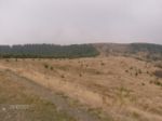 process of natural succession, forests versus pastures, source www.golija.rs
 -
 source www.novipazar.com
 -
 monastery Sopocani,source www.novipazar.com
 -
 monastery Djurdjevi stupovi, source www.novipazar.com
 -
 source www.novipazar.com
 -
 source www.novipazar.com
 -
your image text
-
your image text


References
- Center for Urban Development Planning
About categories: You can add more categories with this tag: "", add your categories