Göreme National Park and the Rock Sites of Cappadocia, Turkey
| Name | Göreme National Park and the Rock Sites of Cappadocia | |
| Place | Kapadokya / Nevşehir | |
| Country | Turkey | |
| Author(s) | Derya Yazgi, Damla Tas | |
| Project start | 1982 | |
| Completion | enter the date of completion | |
| World Heritage | 1985 | |
| Client | Göreme | |
| Project costs | Total Government contribution: 18.065.000 Turkish Liras
Total UNDP contribution: US$ 178.000,289 | |
|
<googlemap version="0.9" lat="38.658169" lon="34.844685" zoom="13" width="400" height="300" controls="small"> </googlemap> | ||

Rationale: Why is the case study interesting?
- Please summarise:- e.g. Design Innovation? Planning Exemplar? Theoretical Insights? Lessons from its failure?
Several reasons stand out why Göreme National Park and the Rock Sites of Cappadocia is interesting:
- Cappadocia is truly unique in the world.
- Cappadocia is on the UNESCO shortlist for regions of world heritage.
- Cappadocia has the basic, though elemental, infrastructure deemed necessary for tourism.
- Existing facilities and capabilities for transportation by air and by land are sufficiently developed for serving any high-capacity destination point.
- Cappadocia is literally an open air museum for ancient and prehistoric cultures who populated the region for more than five millennia.
- Cappadocia is on the historic Silk Road.
Author's perspective
- What theoretical or professional perspective do you bring to the case study? Please make a short note on your personal background
Regarding theoretical or professional perspective,the area should be protected and developed for both scientific and aesthetic reasons.For the protection of areas,it can be used land use management methods such as land-use zoning by restrictions and regulations on building and by the preservation of traditional values.
Cultural landscape context
- Biogeography, cultural features, overall landscape character, history and dynamics
Illustration: Map; sketches; short descriptive analyses
BIOGEOGRAPHICAL PROVINCE: Anatolian-Iranian Desert
CULTURAL FEATURES:
This area has been inhabited since Hittite times when the first caves were excavated and both then, and under Assyrian and Roman rule the nearby own now called Kayseri was an important provincial centre. Being on the boundary between the ancient Greek and Persian empires, and later between the Byzantine Greeks and their Persian, Ummayad, Abbasid, Seljuk and Ottoman adversaries, hidden sanctuaries were often needed which the rugged landscape and easily carved rock of central Cappadocia provided underground. The area was initially a sanctuary for Christian anchorites fleeing Roman persecution which became a monastic community in the 4th century.
For the next nine centuries, an urbanised landscape developed which from the cliffs and spectacular pillars – or ‘fairy chimneys’ - of tuff, carved living quarters, stables, storerooms and places of worship. At nearby Kaykmakli and Derinkuyu a network of deep caves and tunnels in the rock was excavated to form underground refuges for hundreds of people which were expanded during the first hostile invasions in the 7th century, to entire multi-storey underground communities.
The fresco painting in the chapels which began in the 7th century by monks too remote to be much affected by Iconoclasm are colorful rare testimony to the civilization of a province of the Byzantine Empire which persisted even into Ottoman times but, except for these remnants, has since disappeared.
Excellent examples of post-Iconoclastic sacred art have been preserved by the dark and dry conditions underground, and several have been carefully restored. There are many other similar classified monuments in the valley outside the Park (G.Drucker, pers. obs. 1985) and in the surrounding countryside.
DATES AND HISTORY OF ESTABLISHMENT:
- 1968: Proposals and draft management plans drawn up by the General Directorate of Forestry and National Parks;
- 1976: Göreme Valley and surroundings protected by Decree A-69 of the High Council of Monuments and Historic Sites under the Cappadocia General Conservation Plan which required the preparation of detailed development plans;
- 1983: The protection of the site further assured under the Cultural and Natural Assets Act 2863;
- 1986: Established as a Historical National Park under National Parks Law 2873.
Socio-political context
- Brief explanation of political economy, legal framework
Illustration: Bullet points, image, background notes
Tourism has been seen as a major instrument in the political economy of Göreme National Park and the Rock Sites of Cappadocia.The tourism development process shaped the context of socio political issues. Back to top
Spatial analysis of area/project
- What are the main structural features?
- How has it been shaped? Were there any critical decisions?
Illustration: Map/diagram/sketches photos and background notes
That's a unique world shaped by Mother Nature with the help of lava, wind and water. The most striking feature of the landscape is the volcanism which has created dramatic morphological contrasts and produced a wide range of features, from the spur of volcanic cones to the sciare on the lower slopes and the extensive plateau of lava flows. It is a typical example of an area of recent volcanic activity, with the geological structures perfectly preserved, including both the basic features and the whole range of secondary craters and the pyroclastic deposits associated with them.
Analysis of idea/program/function ("Planning Objective")
- What are the main functional characteristics?
- How have they been expressed or incorporated?
Geological,historical and cultural features form the main functional characteristics.The rocks of Cappadocia near Göreme eroded into hundreds of spectacular pillars and minaret-like forms.The volcanic deposits are soft rocks that the people of the villages at the heart of the Cappadocia Region carved out to form houses,churches,monasteries,underground cities,caravanserais,medreses,turbes and mosques.In the history,these formations were used for varied purposes such as living,praying,protection from enemies etc.This location and its surroundings are used as an open air museum now.Morover,there is a massive field of producing wine traditionally.These features attribute to the main functional characteristics of Goreme National Park and the rock side of Cappadocia.
Illustration: Map/diagram/sketches photos and background notes
Analysis of design/planning process ("Process Biography")
- How was the area/project formulated and implemented?
- Who initiated the project and why?
- Which stakeholders have been involved?
- Who made the major decisions and when?
- Were there any important consultations/collaborations?
The major decisions about the protection of the area includes legislative and administrative arrangements.These arrangements can be summarised in the timeline as the listed below:
United Nations Environment Programme-World Conservation Monitoring Centre initiated this project. There are several reasons why this area has been choosen. The area and its surroundings comprise an area of extraordinary landscape which have been entirely sculptured by erosion.It is also on the UNESCO shortlist for regions of world heritage. It is known literally an open air museum for ancient and prehistoric cultures who populated the region for more than five millennia.Located on the Silk Road,it strengthens its historic heritage.
The stakeholders are in the following:
The Internaitonal Centre for the Study of the Preservation and Restoration of Cultural Properties (ICCROM)
United Nations Educational, Scientific and Cultural Organization (UNESCO)
United Nations Development Programme (UNDP)
Middle East Technical University in Ankara
United Nations Educational, United Nations Scientific and Development Cultural Organization Programme made the major decisions in 1982.
Illustration: Map/diagram/sketches photos and background notes
Analysis of use/users
- How is the area/project used and by whom?
- Is the use changing? Are there any issues?
Use of site/property
• Visitor attraction, urban centre, national park, religious use, rural landscape
• Tourist activities and accommodations throughout the region
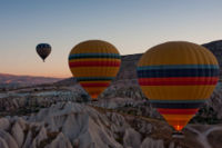
The use of this area has been changing in an attractive way for all the visitors. For example,there are hot air balloons that many tourists can take advantage of using them for seeing all the park and the rock sites of Cappadocia with bird's-eye view.
Illustration: Map/diagram/sketches photos and background notes
Future development directions
- How is the area/project evolving?
- Are there any future goals?
According to Unesco, there are two future actions:
• A management plan will be prepared
• Local conservation, implementation and monitoring units will be established in the municipalities
Illustration: Map/diagram/sketches photos and background notes
Peer reviews or critique
- Has the area/project been reviewed by academic or professional reviewers?
- What were their main evaluations?
Please add references, quotes...
The activities carried out to achieve the immediate objectives were: a photogrammetrical survey; rock sample analysis; meteorological and topographical surveys; a hydrogeological. survey; the purchase of equipment and chemicals; expert missions and study tours and fellowship programmes.
The immediate objectives to be achieved within the time frame set for the project are as follows:
-The development of a series of technically proven solutions to the structural problems of the rock structures of Goreme.
-The consolidation of at least two major rock structures on a pilot basis by applying the techniques and solutions identified as most suitable.
-The establishment of a point of reference,.both from a financial and a technical point of view, for future work on the consolidation of the rock structures in the Cappadocia region.
-The identification of suitable measure? to upkeep the sites and to prevent degradation caused by human factors while at the same time allowing a maximum number of tourists to visit the sites.
The creation of a capacity, both in terms of trained manpower,and organization, to apply the methods and techniques developed under the project systematically on the basis of a priority programme of action.
Successes and limitations
- What do you see as the main successes and limitations of the area/project?
- Through the project activities, co-operation with other organizations was established. At national level with universities such as the Middle East Technical University, the Istanbul Technical University and governmental organizations such as the State Hydrogeological Affairs'and the State Meteorological Office; at international level,' Unesco experts, some chemical firms and laboratories were consulted throughout the project. This collaboration will be carried on at later stages when the results of the project are utilized.
- Success in the project activities requires an effective communication between the parties concerned. Information on procedures followed and purchase orders placed by either of the parties and sub-contracted organizations should be transmitted to the counterpart in order to avoid complications.
Illustration: Summary table
What can be generalized from this case study?
- Are there any important theoretical insights?
-The project was basically a research project. The results yielded by the research was supposed to be implemented on a pilot basis. But as the research has not been completed within the time-frame of the project, the implementation stage has not yet commenced.
-As for the tested chemicals, the results will be taken after a certain length of time, and they will be utilized thereafter according to.their degree of effectiveness.
Short statement plus background notes
What research questions does it generate?
No data available
Image Gallery

Historical Map

Goreme National Park

Goreme Valley

Map

Hot Air Baloons 1

Hot Air Baloons 2
Hot Air Baloons 3

Fairy Chimneys


References
- Author Year: Title, publisher, edition, page, ...
- etc.
- Website Year: Link, keyword, ...
- etc.
Göreme, Cappadocia. UNESCO Programmes & Publications. UNESCO
State of Conservation of World Heritage Properties in Europe
Structural Conservation of Goreme Project Findings and Recommendations
Keywords:cave house, stone, fairy chimneys, underground cities, architectural rock construction.