El Palomar
A new place to meet in Chihuahua, Mexico by Sofia Lopez
| Name | Park "El Palomar" | ||||
| Place | Chihuahua | ||||
| Country | Mexico | ||||
| Topic | open space, parks | ||||
| Author(s) | Sofia Lopez | ||||
| Completion | 1998 | ||||
| Client | Urban Development of the City of Chihuahua | ||||
| Project costs | Please enter the costs (if known) | ||||

| |||||
| <googlemap version="0.9" lat="26.431228" lon="-106.787109" zoom="4" width="300" height="300">
28.632492, -106.080177, Chihuahua, CH </googlemap> |
<googlemap version="0.9" lat="28.639489" lon="-106.087117" type="satellite" zoom="15" width="300" height="300">
28.632492, -106.080177, Chihuahua, CH </googlemap> | ||||
Rationale: Why is this case study interesting?
The area that is now occupied by this park was a poor-rundown neigborhood therefore was also a dangerous part of the city, but after this project it became an important part of the city a public space of recreation and also a place for culture; some years after the park was finish the city built a new library, and a museum. This park have a square that it´s used for a lot of different cultural events like concerts, presentations, festivals, and civic events. It has a good location; close to the center of the city, to the government offices. And it is a "green belt" in the riverside of the river "El Chuviscar" that is almost dry up, also in the city there are not much parks or green public areas.
Author's perspective
As a student of Landscape Architecture and comming from a country were the development in the field of landscape architecture is young, is very interesting to analized this particular park, that was a former run down neighborhood and became a very important part of the city. How the architects manage with the natural slope of the terrain, the intercommunication between a big area such Park "El Palomar", and with a wide range of necessities and users.
Landscape and/or urban context

Park “El Palomar” is located close to the center of Chihuahua city, the capital city of Chihuahua province; the biggest province of Mexico in the border with USA.
The city of Chihuahua has a elevation of 1,480 mt. above sea level, located on a valley in the intersection of the rivers Chuviscar and Sacramento, the first one cross the city in southwest-northeast direction and the second one in north-south direction; it is shaped as a gigantic letter “L” due to the mountainous region located on both sides; to the west one finds the Sierra Majalca and to the east and northeast one finds the Sierra Nombre de Dios were are also located the Nombre de Dios Caverns natural underground formations made of minerals and salt, to the south the city is delimited by three main hills Cerro Grande (2,300), Cerro Coronel (1800) with a viewpoint from one can get a wonderful view of the city and Santa Rosa fully covered by the city. Due to all this natural barriers the city continues to spread in the valley in north direction.
Park “El Palomar” situated close to the center of the city (about 2 km) were the town hall and other government offices are located also some historical buildings, public squares, the market and probably the only pedestrian zone of the city. Crossed by the main avenue “Ocampo” and by the 10th Street and delimited by the main avenues “Independencia” and “Teofilo Borunda” this one follows the flow of the “Chuviscar” river and by the Ramirez Calderon street. Although the park is located very near to the river, this location doesn´t contributes in nothing to the park because actually in the riverside is the “Teofilo Borunda” avenue and it wasn´t planned as a recreational area it was channelized almost 60 years ago and in the other side is almost dry up it carries some water in the rain season.
Since the park is crossed and delimited by all this main avenues is very good connected to the rest of the city. In the adjacent areas are plenty of public facilities in south direction crossing the “Chuviscar” river is located the Museum of Science and Technology “Semilla” (Seed) a learning centre and interactive science museum for children that was completed a year later after the completion of the 1st part of the park. In Northeast direction in the “Ocampo” avenue is located a Public Hospital (IMSS) immediately after is a Sport facility with swimming pool, basquetball court, coffe shop. In southwest direction is located a Public high school. And in the 2nd Part of the Park is located a Public Library with the Historical Records of the City. The surrounding area is also occupied by the remaining portion of “El Palomar” neighborhood and by other residential areas, also with some small commerce located principally in the main avenues.
Cultural/social/political context
- Political/economical context
The most important economical activity of the city are the industrials zones, with six of them spread along the city, were foreign companies most of them from USA have their manufactures; due to this is one of the cities with more level of investment in the country. Another important economical activity that is receiving a lot of investment from the government is the touristic with the creation some years ago of the Touristic Trolley, a bus that makes a tour around the city center stopping in the main attractions, Park “El Palomar” included also with the improvement of the pedestrian zone in the city center and also the city attracts tourists from all over for its own location because is the starting point to explore the little towns located in the mountainous region of Chihuahua and the natural wonders of the Province like the Copper Canyon, Basaseachi Waterfall, Arareko Lake or to take the touristic train that runs from Chihuahua city to Los Mochis city in the west coast of Mexico.
- Social/cultural context
The last census (2005) shows that the city has 748,500 inhabitants and 60% are younger of 30 years, in a city covering an area of about 21,000 ha and with just 1.5% of green areas, therefore Park “El Palomar” is an important recreational area, probably the most important, biggest and public green area in the city.
History
The city of Chihuahua was founded on 1709 by Antonio Deza y Ulloa a spanish explorer, the location was chosen because it is located in a valley in the intersection of the rivers Chuviscar and Sacramento and also because it was midpoint between some then-important mines. The original name of the city was “Real de Minas de San Francisco de Cuellar” then in 1718 the name was change into “San Felipe el Real de Chihuahua” and lately in 1823 the name was shortened in Chihuahua. The city development was as a miner and supplier city for the closer towns located in the mountainous region in western Chihuahua province.
-
 Map of the City 1916 (Historic Record of the City)
 -
 Neigborhood "El Palomar" 1985 (Historic Record of the City)


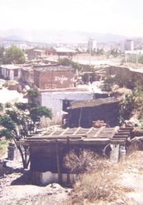
The first settlements in the area of Park “El Palomar” were between 1890-1900 in the outskirts of in this time city, that was delimitate by "Chuviscar" river; with just some families that used the land in the riverside for agricultural purpose, some years later (1905 approximately) the establishment of a foundry company in this area called “Fundicion San Felipe” that built a railroad from the central railway station to transport their mineral production; contribute to the settlement of more families; and the proper formation of the neighborhood “El Palomar”. The area presented an irregular shape and a dangerous location (riverside) due to floods, also it was isolate from the rest of the city and almost incomunicate, the river make it difficult, therefore the lack of good infrastructure; with the channeling of the “Chuviscar” river from 1956 to 1960 and the construction of bridges that cross the river, the quality of the infrastructure got a real improvement. In the 60´s the neighbors set up a committee and pressure the authorities to get a better infrastructure (roads, sewage) and also an urbanization program. With this program the quality of life improves a little but it continue to be a poor-rundown neighborhood. Then at the beginning of 1990 the Government became aware of the necessity of a public space that could be used for different proposals but mainly a recreational space for the city.
The neighborhood “El Palomar” was chosen for this proposal due to the excellent location, good views and also for being a rundown neighborhood. Demolition of a larger portion of the neighborhood started at the end of 1993. The beginning of the 1st Part (Teacher´s Square-Viewpoint) of the park begins in 1994.
Spatial analysis of area/project/plan

The area that comprehend the park is very extensive about 16 ha, therefore was split in three main areas, this division was natural due to the terrain in were the park is located, with the already existing main avenues. This division also helps to set a different main purpose for each area and to make the management of the construction easier.
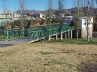
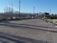
The 1st Part (Teacher´s Square-Viewpoint)with an area that covers 5.8 ha, is divided by a internal street in two, also that each of this parts have a different purpose; the 2nd Part (The Pigeons) with an area of 4 ha, both parts enjoys the wonderful views of the city thanks to the natural slope of the terrain. The 3rd Part (Extreme Park)with an area of 7 ha is a little bit hide in a depression of the terrain, but well connected to the other parts of the park. As the park is divided, the interconection between the different areas is important a bridge connect the 1st Part (Viewpoint) of the park with the 2nd Part (The Pigeons) allowing the pedestrians to cross the main avenue Ocampo and get to the Public Hospital (IMSS). This main avenue that cross the park also connect it with the city centre. An underground passage connects the 1st part with the 3rd one, crossing the 10th Street and linking the park with the neigborhood Mirador and also with the remaining section of neighborhood El Palomar. In each part of the park are located parking lots, because in the city is the main mean of transport; and the main avenues that delimited the park makes easy to get there by car. This parking lots are enough during the week, but at weekends it is difficult to find a parking space, and when a event is held in the Teacher´s Square is impossible this cause the invasion of private properties and also of the adjacent streets. There are two bus stops, one in the Teofilo Borunda avenue and the other one in the Ocampo avenue in front of the hospital. Also a taxi stand is located in the internal street that divides the 1st Part.

Core questions working group open spaces
How does the design of an open space contribute to a run down neighbourhood?

The design of an open space always has an impact; it could be social or economical; positive or negative. In most of the cases if the open space is well planned and designed the impact or contribution would be positive. And this contribution is not just when hte open space is designed for a run down neighborhood; an open space also contributes to a regular neigborhood, area.
Comparing the other cases of study i realized that just my case of studie was located in a former run down neighborhood; but i also found that there are some contributions that a new open space make for both kind of neighborhoods, areas. The principal is that the open space reise the quality of life of the people of the neighborhood or the town, in the case of Park "El Palomar" it has improve not just the remaining portion of the neighborhood and the perspective that the people had of this neigborhood; it also improved the quality of life of the people of Chihuahua giving them a new public space for recreation and also for cultural and civic events. Also helps to bring the people together like in "El Palomar" or most specifically in the "Mauerpark" that even help the people to recover from the separation of Germany. Open space contributes also giving or strengthen the identity of the neighborhood like in "Naturpark Südgelänge" that it was an initiative of the citizens.
Two specific contributions that an open space brings to a rundown neighborhood is increase ot the safety this contribution could be also present in the other spaces but in a different way for example with the creation of pedestrian and bicycle paths or containing the traffic into an specific zone and improvment of the reputation of the area; this improvment is closely related with attracting investment to the area and is also present in the other space, like in the Diplomatic Quarter in Riyadh.
How are open spaces linked to the adjacent areas?
Park "El Palomar" for its own location is very well linked to the adjacent areas. As the park is divided in three main parts, a bridge connect the 1st Part of the park with the 2nd one allowing the pedestrians to cross the main avenue Ocampo and get to the Public Hospital (IMSS). This main avenue that cross the park also connect it with the city centre. An underground passage connects the 1st part with the 3rd one, crossing the 10th Street and linking the park with the neigborhood Mirador and also with the remaining section of neighborhood El Palomar. For connecting an open space is very important the location since the beginning; the space could be connected with the adjacent areas with bridges, pedestrian paths, underground passages, main avenues; it could be also connected visualy.
How are open spaces used?
The way an open space is used depends on what does the place offers to the public. Park "El Palomar" as an open space was planed mainly like a recreational area; where the people could meet, relax and enjoy the views of the city, but also offers the possibility to be used for cultural and civic events.
Which elements make an open space successful and attractive?
An open space could be successful and attractive for three main reasons:
- Location: easy access, well connected to the city by the public transport or by avenues,streets
- Views: views facing to a river, city, lake or montainous region
- Activities that the people could develop: cultural activities, recreational, sports, civic events
In Park "El Palomar" this three main reasons are present, with a good location, well connected to rest of the city by the main avenues and streets that delimited it; wonderful views of the city, thanks to the natural slope of the terrain and a wide range of activities that can be develop in the different parts of the park.
How can the historical background of an open space be shown to the public?
Park “El Palomar” doesn´t have an important historical background; it was a rundown neighborhood, but the name by itself reminds us of the origin as a former rundown residential area and also with the sculpture “Las Palomas” (The Pigeons) that is located in the 2nd Part of the park.
Analysis of program/function
The aim of this project was to create an open space were the people of Chihuahua could meet, and develop different kind or recreational activities; the key word in the necessities of this park could be summarize in one single word –Multi-Functionality-.
Main functions:
- Sports
- Space for civic and national holidays
- Recreational area (take a walk, reunion place, enjoy nature, enjoys views)
- Cultural
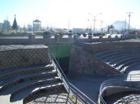
The main functional characteristic were expressed by the creation of different parts, each of one covering one or two functional characteristic. The 1st Part “Teacher´s Square” fulfill the main function of a space for civic and national holidays, and with the incorporation of the stage is also suitable for other kind of events (cultural, performances) fulfilling also the important point of multi-functionality. The “Viewpoint” and “The Pigeons” cover the function of recreational areas with the incorporation of promenades, resting areas, the viewpoint to improve even more the views of the city, the kiosk that gives the opportunity to eat something, and the green areas to enjoy the nature. The function that the “Extreme Park” covers is very clear, offers a space to do sports with the different fields that were incorporated, the in-line skating area; but is also suitable like a recreational area with the green areas, promenades along the two internal streets that cross this part of the park and the resting areas.
Analysis of design/planning process
The project was formulated by the Urban Development Office of the city of Chihuahua; i do not have more information available.
Analysis of use/users

The park was created to be used by a wide range of users, because of its importance in the city; it is used by families from the whole city and of the adjacent neighborhoods, most of them middle class, students, young people, elderly; of course that every group of users utilize the part of the park that suit better to their necessities. The different parts were created for a main use:
- Teacher´s Square – civic, cultural events
- Viewpoint – recreational
- The Pigeons – recreational
- Extreme Park – sports
But the spaces are multi-functional particularly the Teacher´s Square, the stage is used for a wide range of different performances: musicals, dance, etc. also it has been used for political events. The square is use for some civic events and in the national holidays for the flag ceremony in the big flagpole. In the month of October takes place the “International Festival of the City” with a lot of exhibitions and other kind of cultural events, and a lot of them take place in this square. The square is just used when there are held events either is during the week or at weekend, and the kind of users depends on the type of the event that its held.
The other parts have a more specific use, the Viewpoint and The Pigeons, are particularly suitable to spend a leisurely afternoon with family or friends, take a walk, eat something in the kiosk, flying kites or simply enjoy the wonderful sight of the city. During the week are used mostly for casual users, people that is visiting someone in the hospital, students getting to the public library, or from the close high school; also when is held some event in the adjacent Teacher´s Square the people stays in this parts. During the spring-summer weekends is the main use, but also well used in the remaining time of the year.
The Extreme Park have a very specific use –sports- with the soccer field, basketball field, in-line skating area, in this areas the main users during the week or weekend are young people (adolescents) from the adjacent neighborhoods, or from the high school; that meet there just to talk or to practice some sport; in the playgrounds the users are families with kids. This part is also used for bicycling in the two internal streets that cross the park since in the city there are any bicycle paths and this internal streets are kind of secure without much traffic. The use of the park and the users are actually expanding every weekend you can find more people. The Teacher´s Square at the beginning it was used just in national holidays or for civic events, nowadays is used also for cultural, political events; in Christmas was used for a Christmas Market with a ice-skating rink, and it would be use also for the events that are going to take place for the three hundred years of foundation of the city. The Park in general is becoming more and more important to the citizens. A place to meet.
Future development directions

The Urban Development Office with the Government of the city of Chihuahua is staring to implement the new Plan of Urban Development for the city until the year 2040. One of the goals is to create a greener city with more open spaces and promote the use of the bicycle as transport in a city were the proportion of cars is one car for every two inhabitants; with the creation of 16 km of bicycle paths in the first part of the project and in the next years a total of 88 km of bicycle paths.
As Park “El Palomar” is one of the biggest and important parks of the city, the project for the construction of a fourth part of the park; is beginning in the next year, the new part of the park would cover an area of 14,000 m2. With more green areas, promenades and siting areas.
Also this year would start the construction of a bridge to celebrate the 300 year of foundation of the city, that would cross the “Chuviscar” river and would connect Park “El Palomar” with the Museum “Semilla”.
The propose of creating more open spaces in the adjacent land to the 4th Part of the park that is without use, is going to be exposed to the Urban Development Office by a group of architects of the city of Chihuahua, if this proposal is accepted it would start to create a green belt in the middle of the city.
Peer reviews or critique
Information not available for this case of study.
Points of success and limitations
Points of Success:
- The achievement to create a multi-functional space covering the main functions (necessities).
- Achievement of suitability for a wide range of users
Limitations:
- I think that the natural slope of the terrain were the “Viewpoint” and “The Pigeons” are located should be better used; taking more advantage of this characteristic of the terrain; this two areas covers 7.3 ha this means 45% of the total area of the park and the area without real use because of the slope is 3.28 ha this means 20.5% of the total area of the park, so is a lot of area without a real use beside being a green area, because some parts are not even appropriate to walk or sit in, I would say even a little dangerous. The terrain could be better used with the creation of terraces.
- Another point of limitation that I found in general in the city not just in this park is the use of not adequate vegetation for the weather and kind of land of the city; this causes an enormous cost of maintenance and misuse of water.
But in general I think that the park is well done, since the landscaping in the city is relatively young.
What can be generalized from this case study?
- Are there any important theoretical insights?
Short statement plus background notes
Which research questions does it generate?
Short statement plus background notes
Image Gallery
-
 "Chuviscar" river Channelized photo by Sofia Lopez
 -
 Promenade "The Pigeons" of the Park photo by Sofia Lopez
 -
 Resting Area "The Pigeons" photo by Sofia Lopez
 -
 Bridge between "Viewpoint" and "The Pigeons" photo by Sofia Lopez
 -
 Bridge photo by Sofia Lopez
 -
 Natural slope photo by Sofia Lopez
 -
 Natural Slope "Viewpoint" photo by Sofia Lopez
 -
 View from "Viewpoint" photo by Sofia Lopez
 -
 View from "Viewpoint" photo by Sofia Lopez
 -
 "Teacher´s Square" photo by Alfa Lopez
 -
 Event "Teacher´s Square" photo by Sofia Lopez
 -
 Christmas Fair photo by Sofia Lopez
 -
 Entry underground passage photo by Sofia Lopez
 -
 Playground "Extreme Park" photo by Sofia Lopez
 -
 Skating area "Extreme Park" photo by Sofia Lopez
 -
 Promenade photo by Sofia Lopez
 -
 Public Hospital photo by Sofia Lopez
 -
 View of the Museum "Semilla" (Seed") photo by Sofia Lopez
 -
 Public Library photo by Sofia Lopez


References
Consultation of Historical Records of the City - Mediateca Chihuahua
Chihuahua City [1]
About categories: You can add more categories with this tag: "", add your categories