Collaborative Design Planting Design Working Group 9
---> back to group page working group 9
The Green Network of the Pedestrian Bridges
| Name | The Green Network of the Pedestrian Bridges | |||||||||||
| Location | Amman عمان | |||||||||||
| Country | Jordan | |||||||||||
| Authors | Elena Mihai, Esra' Najjar, Michael Biederer | |||||||||||

| ||||||||||||
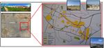
| {{#widget:GoogleMaps | width=300 | height=200 | lat=31.95 | lng=35.9 | zoom=10 | centermarker=yes | maptypecontrol=yes | overviewmapcontrol=yes | largemapcontrol=yes | scalecontrol=yes
}} | ||
Landscape and/or urban context of your case
The Unfriendly Pedestrian City, The Unwalkable City, The City of the Pedestrian Bridges, The throttling Congestion, The sightless Sidewalks, The City of Flux and The Automobile City are all terms that describe the transport system of the city of Amman. Amman, the capital city of Jordan, began with the arrival of Circassians immigrants in 1878. Circassians resettled the valley (Wadi Amman).
The historical statistical studies estimate that between 2000-3000 inhabitants have settled in Amman in 1800-1900. In 1920, Amman has been declared as the capital city, the city began to creep up the slopes of the surroundings hills and spreads over the mountain tops. Amman is situated in a hilly area of north-western Jordan. The city was originally built on seven hills, but now spans over an area of nineteen hills (each known as a Jabal).
Currently, Amman has a population in excess 2 million. The growth of Amman from the 1920s to the present has been phenomenal; in terms of its population, physical extent and regional geopolitical importance. The phenomenal growth of the urban area in both size and significance has occurred in “drastic growth spurts that have transformed the look and feel of the city…and its connections with the outside world” (al-Asad 2005).
The unexpected phenomenal growth and the limited future planning conducted fundamental challenges in Transport System and Open Public Spaces. If there is a single word that characterizes the urban transport system of Amman it is ‘congestion’. Al-Asad (2005) has lamented that since the 1990s Amman has “become a more congested city in which it is increasingly difficult to drive, and through which it is almost impossible to walk”.
A significant defiance is the priority of pedestrians in Amman streets. Crossing a number of Amman's busy streets is a nerve-wrecking and life-threatening experience. The conversion of numerous traffic light intersections into underpasses and overpasses has made life even more difficult for pedestrians. Thus, the Greater Amman Municipality suggested starting creating Pedestrian Bridges, Foot Bridges or overhead bridges as an immediate solution for the non-functional sidewalks and to the threatening experience in streets crossing. However, pedestrian bridges are not the distinctive solution, the equivalent of about two floors to cross a street; the unclean, unsafe, unlighted bridges are unattractive nodes for pedestrians.
Pedestrian bridges have been established in the late 1980s, they were built somewhere in the last 20-30 years. So historically, they still can’t be added to the main structural layers of the transport systems.
At the end, some questions that are raised as, How can we attract the pedestrians to better use of the overhead bridges? Can the bridges modify to be Public Green Spaces? And can the bridges link Amman East and West?
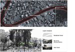
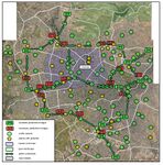
- Context and Statistics
-
 Circassians Immigrants
 -
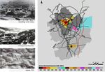 Amman Expansion
 -
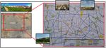
 Context Layers
 -
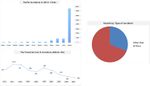 Traffic Accidents Statistics


What are the objectives of your design?
- Preserving ecology by establishing a green network - landscape, making possible a link through Amman using native plants-awareness of sustainability and quality of life.
- Implement sustainable design approaches for creating the green network by using the obtainable resources and easily maintainable bridges that allows future modification.
- Re-define the term public space in a society that the term is only relating to shopping malls and very few parks.
- Promote the green network as a major element in developing renewable energy (natural cooling systems and green –courtyards- platforms).
- Enriching the image of the city for pedestrians, by encouraging the safe crossing through an attractive experience.
- Consolidate the fragility in East and West Amman by creating a perceptual correlation due to the green overhead bridges network.
Analytical drawings
'Analysis Phases
1- Understanding and analyzing the context of the case through Concept Mapping'
-
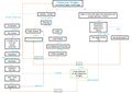 Understanding the Context, Concept Map

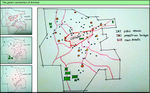
2- After many discussions of the main potentials and problems, the group has decided to involve the social layer through Questionnaire on the network of the pedestrian bridges '
-
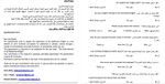 Sample of the Questionnaire Form
 -
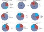 Questionnaire Findings


3- Analyzing two different pedestrian bridges in location Amman, East and West '
-
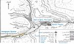
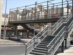
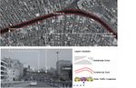 Amman West (Jubayhah), Pedestrian Bridge Analysis
 -
 Amman East (Ras Al-Ein), Pedestrian Bridge Analysis
,_Zone_Analysis.jpg)
,_Zone_Analysis.jpg)
4- Analytic drawings approaches
Approach A
-
 green connection in Amman, current situation, analytical drawing done by Michael Biederer

Approach B
-
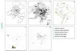
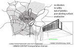 urban context in Amman, current situation of pedestrian bridges E.M.
 -
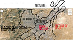 urban textures, textures are important because they can give a general picture of what is happening in a teritory and what type of structure is predominat there
 -
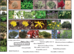 some of the local plants in Jordan, these matter as for further design material
 -
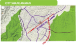 city shape, there are basicly 2 force lines depends as you are looking at the town of Amman, you can see it from street point of view or you can see it as how it is positioned regarding the elements of nature, more specific the desrt. A further integrated approach of any type of design shood consider the image of the town and relationship with nature elements


Approach C
-
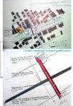 Context, Pedestrian Bridge Physical Analysis
 -
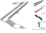 Pedestrian Bridges Components
 -
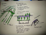
 Scenario A, potentials and problems
 -
 Scenario B, problems


Case Studies
Case study of pedestrian bridge envisoned by Heatherwick Studio;way for Londoners to safely commute from the North to the South side of the city that doesn’t involve the hassle of waiting for a bus, squeezing onto the overcrowded “Tube,” or sitting in mind-numbing traffic, source http://blog.archpaper.com/wordpress/archives/tag/pedestrian-bridges
Also casestudy of another pedestrian bridge from Squibb Park Pedestrian Bridge, source http://blog.archpaper.com/wordpress/archives/51069
Projective drawings
- Projective Drawings
-
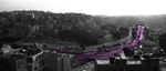
 green connection between the pedestrian bridges in the West of Amman
 -
 green connection between the pedestrian bridges in the East of Amman
 -
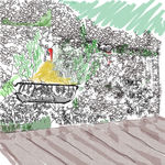 Detail from the bridge
 -
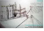
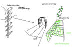
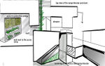 proposal sketch 2, proposal for elevator and ramp for disabled people, building a support wall with nautural materials and incorporating plants to design
 -

-
 in 20 years and in 50 years prospective design the way it might become
 -
 Scenerio A Proposal
 -
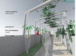 Scenerio B Proposal
 -
 Scenerio C Proposal
 -
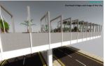 Scenerio D Proposal, Bridges and the Image of the City


Design Synthesis
Please analyse the individual approaches presented so far and evaluate their strengths and weaknesses (you may use the SWOTanalysis model). Try to create a synthesis and represent it with a plan and some sketches. You can still use drawings/sketches.
- Design Synthesis Drawings
-
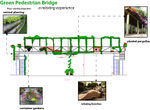
 MAP
MAP -
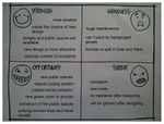 SWOT
SWOT -
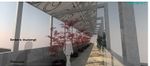
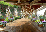 bridge perspective
 -
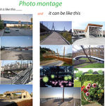 photo montage
 -
 detail
 -
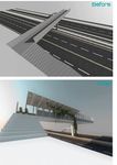 Before and After


Summary of the collaborative process
The design area was chosen after each member came with an idea of a possible theme. Each theme was discussed and we concluded that pedestrian bridges in Amman was the subject that was right for us. Then, before we started thinking about analytical drawings we asked ourselves what do we want from this project, what exactly we want to design and what will be the purpose of that design, and so our objectives were born. Our aim was to create a green network and to serve also on social levels using the designs, more exactly to consolidate the fragility in East and West Amman by creating a perceptual correlation due to the green overhead bridges network. Later on we learned more about the site, we had statistics and plenty of information about the area and how everything developped. Each of us sees things in a different way due to our different professional background, so we found necessary to divide the analytical phase into several different approaches that would meet the need of the team. However in the projective drawing phase our concept about what can be are slightly alike, with differences regarding the shapes and design, so for us the synthesis was a process of sincretism mostly. Having reached the end of our project we think we had achieved what we wanted at fist from our designs, that they meet the objectives we formulated at first, but there is always place for improvement. We also learned more about ourselves and about others. This was for short a description of a semester of meetings, discussions and work.
Image Gallery
You may add a series of images/photos in addition to the sketches/drawings
- Image Gallery
-
 Context
 -
 Bridge steel structure
 -
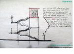
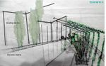
 proposal sketch 1, proposal of 2 types of shading systems, 1 involving solar panels and the other one involving classical pergola system along with using Hedra helix as decorative plant
 -
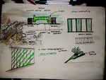 image 2
 -
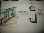 image 3
 -
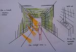 image 4


References
* Please make sure that you give proper references of all external resources used.
* Do not use images of which you do not hold the copyright.
* Please add internet links to other resources if necessary.
- http://blog.archpaper.com/wordpress/archives/51069 ;
- http://blog.archpaper.com/wordpress/archives/tag/pedestrian-bridges ;
- https://maps.google.ro/maps?q=amman&hl=ro&sll=44.437833,26.095893&sspn=0.281417,0.617294&t=h&hnear=Amman,+Iordania&z=16
About categories: You can add more categories with this tag: "", add your categories