Collaborative Design Planting Design Working Group 6
---> back to group page working group 6
Tayrona National Natural Park: Natural environments, and how they return us to our roots.
| Name | Tayrona National Natural Park | |||||||||||
| Location | Colombian Caribbean - Magdalena | |||||||||||
| Country | Colombia | |||||||||||
| Authors | María Fernanda González Duque, Hyeyoon Choi, Ladan Badiee, Jeroen Geudens | |||||||||||

| ||||||||||||
| {{#widget:GoogleMaps | width=300 | height=200 | lat=11.296934 | lng=-74.166496 | zoom=8 | centermarker=yes | maptypecontrol=yes | overviewmapcontrol=yes | largemapcontrol=yes | scalecontrol=yes
}} | ||
Landscape and/or urban context of your case
The Tayrona National Natural Park (Spanish: Parque Nacional Natural Tayrona), is located in the Department of Magdalena, north of Colombia, in the Caribbean sea. With approximately 30 Km2 of maritime area and 150 Km2 of land area, is one of the most visited Natural parks of this country. Its extension goes from Taganga (western side) trough the coastline, until the Piedras River (eastern side).
-
 Park Location
 -

-


- Biogeography:
Ecosystems: Due to the different altitudes presents around the park and the pyramid shape of the mountains, we can find temperatures between 25º and 32º, these conditions makes the park have a very dry or wet weather; here we can find tropical rainforest, dry forest, spiny forest, submontane forest, cloud forest and several ecosystems, such as Mangroves, Seagrasses, Coral reefs, Rocky coastline, Lagoons, etc.
Hydrography:
Consists of two drainage systems, the maritime one is formed by a set of small streams and creeks that flow into the sea and the continental one is formed by the streams that flow into the Rio Piedras.
Flora:
The park has a natural wealth flora of over 350 maritime species and 770 terrestrial. The coastal zone has the greatest wealth of marine vegetation of the whole Colombian Caribbean, with more than 31 types of different plants.
Forest and xeric and sub-xeric shrublands:
Trupillo (Prosopis julliflora)
Aromos (Vachellia tortuosa)
Palo Brasil (Haematoxylon brasiletto)
Dividivi (Caesalpinia coriaria)
Guamacho (Pereskiaguamacho)
Cardón de higo (Subpilocereus russellianus)
Tuna (Opuntia wentiana).
Dry broadleaf forests:
Elephant Ear Tree (Epiterolobium ciyclocarpum)
Jobo (Spondias mombin)
Naranjuelo (Crataeva tapia)
Guayacán (Guajacum)
Ébano (Caesalpinia ébano)
Ceiba or majagua (Pseubombax maximun)
Tropical rainforest:
Bryophyta sensu stricto
Bromeliáceas
Araceas
Orchidaceae
Fauna:
The park has an extensive fauna, 15 species of amphibians, 202 species of sponges, 471 species of crustaceans, 96 species of annuals, 700 species of molluscs, 110 species of corals and 401 species of sea and river fish, 108 species of mammals, 300 species of birds, 70 species of bats, 31 species of reptiles.
Felidae (Feline): Panthera onca (Jaguar), Leopardus pardalis (Ocelot), Leopardus wiedii (Margay) and Puma yagouarondi (Jaguarundi)
Cervidae (Deer): Mazama americana (Red brocket) and Mazama rufina (Little red brocket)
Dasyproctidae (Ñeque): Dasyprocta punctata(Central American agouti)
Tayassuidae (Zainos): Tayassu tajacu (Collared peccary)
- Cultural features:
History: The Tayrona, an ancient indigenous group of chiefdoms, dwelled this region (Sierra Nevada of Santa Marta) between the 800 a.C. and the 1600 a.C., before the arrival of the Spanish in Colombia, their economy was based on agriculture of fruital trees, corn crops and plants. They developed their civilization at 900 - 2000 meters above the sea, due to the mild climate and the variety of local products.
1498: First contact between indigenous and Spanish with Fernando González de Oviedo.
1525: Foundation of Santa Marta city.
1525-1599: Instability between Tayronas and Spanish which led to intense periods of conflict and war.
1600: Beginning of the decimation of the indigenous in hands of the Spanish.
-
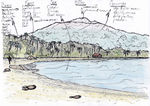
 Ilustration: Sierra Nevada of Santa Marta
 -
 Ilustration: The population
 -
 Ilustration: The cities
 -
 Ilustration: Period of conflict with the Spanish


The survivors of this decimation were interned in the highest parts of the massif to escape from the Spanish; their descendants are the Kogi, who has maintained themselves isolated so far.
1973: A grave robber, found Lost City (Spanish: Ciudad Perdida).
1976: A Colombian scientific expedition arrived to the Lost City and begging with a process of restoration and conservation of the archaeological remains and the terraces of the city and the entire park.
1979: Is declared a Biosphere reserve of humanity by UNESCO
-
 Tayronas descendants, The Koguis
 -
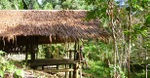
 Kogui's Houses
 -
 Kogui's cities


The Eco-tourism there, is a great way to being interest and economic infrastructure to the reserve, without causing any damage to the ecosystem. It is amazing to be able to witness such a variety of ecosystems and also the archaeological remains of a Tayrona city of pre-colombian Colombia, the white sand beaches and waters in deep blue, gives great natural and historical diversity to the landscape.
What are the objectives of your design?
Please give a short written argumentation (not more than 150 words). It is ok if you have different or even contradicting objectives within your group. Just make it explicit at the beginning of your process
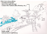
■ Accessibility Improvement Plan with Eco Train
One of the issues in Tayrona National Natural Park is accessibility. There are only two ways to access with boat or on foot through trail course and both takes about 1 hr. In case of boat, it is limited by tide. To improve accessibility, I want to suggest eco train in Tayrona National Natural Park. Train is the most eco friendly transportation and it is already introduced in primeval forest in Jeju Island, Korea. It minimizes the effects on forest with single lane narrow mini train but provide a great experience for tourist to observe virgin nature of volcanic forest.
To minimize interference on nature in Tayrona Park, it is strongly recommended to set buffer zone along coastal line, where the most popular spots exist and plan the lane of train inside of buffer zone. Train is operated regularly and it is possible to restrict people explore outside of buffer zone so core area of nature would be preserved efficiently. Furthermore, guide explanation in the train could help tourist understand cultural and historical background.
■ Sustained ecotourism focused around modified beach accessibility
Because there already is very limited access to large parts of the natural park, there is a lot of pressure to the areas that are open to visitors, especially the beaches. To prevent the beaches getting littered and the coral reefs getting damaged/destroyed, I'd like to propose a few design interventions to spread the visitors over a larger area of the nature park, keeping in mind not to disturb the flora and fauna too much. For that, wooden decks would be used to make very inaccessible areas such as the mangroves or steep hills more in reach of ecotourist or locals. Boulders and rocks can be used to prevent access to over-used beaches, (temporarily) allowing them to recover. Small boats leaving from a boathouse could also transport people to remote areas for a small fee, which can then be used for the preservation of the park. Hiking trails could be expanded, with the compulsive use of guides to prevent disturbing wildlife or getting into dangerous situations. The area is large enough for 3 to 4-day hiking routes, something I've seen to be very popular in South Africa, whilst being ecologically tolerable.
■ Mitigating issues of rubbish and improving camping areas
More than 27.000 tourists visit the Tayrona National Natural Park per year, producing more than 120 tonnes of rubbish. This had become a problem because there are just 30 people in charge of the rubbish collection, and they have to go trough thin and remote paths to collect it all. The most problematic areas are the beaches of Arrecifes and Cañaveral, where most tourists stay when they visit the park. Also indigenous peoples are starting to consume food from outside the park,( food cover by plastic wrappers, glass bottles, etc.),of which,they do not know how to despose properly, resulting in the rubbish being burried on site. To solve this problem they are recycling the plastic, glass, and other kind of materials in sisal sacks to then take it out of the park. My proposal to make this more effective is to divide the park in sectors, each sector will have new stone pedestrian routes wich lead to a collection point at the shoreline; then the rubbish collection will be easier. Also, the camping areas will be isolated, away from the park by using native vegetation around these areas as green barriers.There should also be crops where food can be collected, this area should be located inside the camping areas, in that manner the waste can be recycled, in a more environmentally friendly way (like the indigenous do).
Analytical drawings
- Analytical Drawings
-
 Elevation of the Park, main different heights
 -
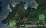
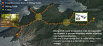
 Accessibility and Improvement Plan
 -
 Different natural areas
 -
 Best Path For Hiking Trail & Native Camps
 -
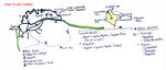 How to get to the Park
 -
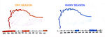 Best time to go (weather)


Projective drawings
- Projective Drawings
-
 Railway and Planting Plan
 -
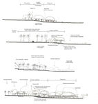 Beach accessibility & Improvements
 -
 Hiking Trails & Native Camps
 -
 Mitigating issues of rubbish and improving camping areas


Design Synthesis
Please analyse the individual approaches presented so far and evaluate their strengths and weaknesses (you may use the SWOTanalysis model). Try to create a synthesis and represent it with a plan and some sketches. You can still use drawings/sketches.
- Design Synthesis Drawings
-
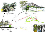
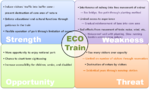 Analysis on eco-train
 -
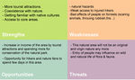 Analysis on hiking & camping
 -
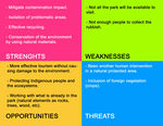 Analysis on rubbish issues and improvement of camping areas
 -
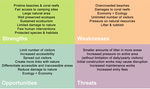 Analysis on making the entire park more accessible


Summary of the collaborative process

Image Gallery
You may add a series of images/photos in addition to the sketches/drawings
- Image Gallery
-
 Jeju Island Eco Train
 -
 Single track east coastal line in Korea
 -
 Jungle Camp, by Poring Hot Springs, Mt Kinabalu
 -
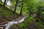 Roodkhan Fotress Way,Iran


References
http://www.parquesnacionales.gov.co/PNN/portel/libreria/php/decide.php?patron=02.020217 http://www.lonelyplanet.com/colombia/caribbean-coast/parque-nacional-tayrona http://discoveringice.com/travels/south-america-colombia/the-ultimate-guide-to-tayrona-national-natural-park-santa-marta-colombia.html http://www.colombia.travel/en/international-tourist/vacations-holidays-where-to-go/recommended-weekend-destinations/tayrona http://parquenacionaltayrona.blogspot.de/2009/07/clima.html