Green Infrastructure 2014 Group E - Case Study 3
---> back to group page working group E
Rehabilitation of the urban center "Coeur de ville" in Montreuil-sous-bois, France:
Potential of Green Infrastructures for social benefits in suburban areas.
| Name | Urban center "Coeur de ville" | |||||||||||
| Country | France | |||||||||||
| City | Montreuil-sous-bois | |||||||||||
| Authors | Lola de Vathaire | |||||||||||

| ||||||||||||

| ||||||||||||
| {{#widget:GoogleMaps | width=300 | height=240 | lat=48.862278 | lng=2.442095 | zoom=10 | centermarker=yes | maptypecontrol=yes | overviewmapcontrol=yes | largemapcontrol=yes | scalecontrol=yes
}} | ||
Rationale: Why is this case interesting?
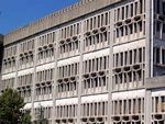
The rehabilitation of this large urban square surrounded by administrative buildings of the city of Montreuil in the periphery of Paris, should help improve social cohesion around the city center. In fact, Montreuil is a dormitory town, which had known an important development of low-cost residential areas to create accommodations very quickly for migrant workers from the French regions or from abroad during the twentieth century. In this kind of suburbs ran by communist majors, there were few economical and commercial activities. Urban planning were mostly answering questions regarding habitation and transportation, disregarding recreation and environmental protection. The good connections to Paris, the capital city caused a slowdown of social and cultural developments. The poor connections to other parts of Montreuil and to other suburbs impeded the increasing of property values.
In the past years, the destruction or renewing of buildings of the 50s-70s free some places in the city like on this quarter "coeur de ville" (heart of the city). Places with a lot of potential to create a local life for communities, improving quality of life and restoring some natural functions of nature.
Author's perspective
As a student of landscape architecture, working in Germany a land ahead in matter of sustainability and green infrastructure, I often though about the possibilities for this square and the waste of resources that anterior designs caused, as I was visiting my family in Montreuil.
After a new rehabilitation, two years ago, I was disappointed to see that important structures of the urban landscape were not integrated in the planning, wasting again a lot of potential to improve quality of life and landscape in this area.
I would like to use this exercise, to point out which methods and patterns contribute to urban heat island, greenhouse effect, etc and propose green infrastructure solutions in an integrative and adaptive design.
Landscape and/or urban context of your case
- widths="300px"
-
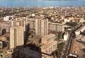
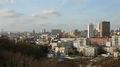 Overview of Montreuil´s urban landscape from the still forested hills

- Biogeography:
Montreuil is situated in the Paris basin with a semi-oceanic, temperate climate. It can be dissociated in two parts because of the geological formation of the area it was built on. The nether city belongs to the valley of the Seine, a formal wetland characterized by impermeable clay soil. The upper city is built on three hills and benefits of drinking water sources and gypsum resources in a calcareous soil. Due to the urban development there is no reminds of the original flora and fauna as well as the wetland and forest, only post-industrial, semi-natural landscapes and parks created mostly on closed gypsum mines.
- widths="483px"
-
 Overview of topography and semi-natural parcs, examples of biodiversity in the "Beaumonts" parc.

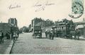
- Historical urban development:
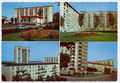
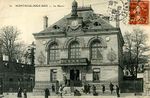
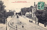
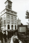
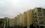
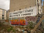
The city is called Montreuil because it was built around a monastery in the early middle-age. This first village knew a demographic and economic explosion after the construction of a new castle for the French royal court in Vincennes, 10km away. Since the XIVth century, Montreuil provided water, vegetable crops, wild games or livestock to Vincennes, Versailles then Paris. The resources of Montreuil are necessary for the capital, especially drinking water that always felt in Paris. That is why it was one of the first city in France to be industrialized and to know a modern urban development in order to supply parisians quickly. Since the early 1900s, the center of the town is connected to Paris with public transportation like busses and trams offering cheap land to construct residential building in masses. The city hall, which is managed since 1935 by the communist party organized wide constructions project to create as much social habitations as possible on the little space of the city in the 50s-70s. Some decades later, the state of this housing stock was already miserable. The poor quality of live of the inhabitants caused dissatisfaction and even riots like in other suburbs near Paris.
- widths="200px"
-
 1770
1770 -
 1907
1907 -
 1960
1960 -
 1970
1970


- Culture and cityscape:
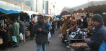
The inhabitants of Montreuil were farmers and workers as reflected by the statues of the sculptor Gilbert: La Jardinière et l'Ouvrier (1944). Today, they represent more than 90 nationalities and a quarter of them shuttle to work in the capital. Montreuil is known to be the first city with a cinema studio in France and for its gypsy community with strong cultural traditions (Gypsy Jazz). In 1900 emerged a first middle-class which built mansion house inspired by the parisian style. In the 80s, a community of intellectuals and artists discovered this historical city in the suburbs. Since then, the village flair of Montreuil and the low rent/sale prices attract parisian workers looking for one of the last houses of the region (20% of the habitation stock in houses).
- widths="150px"
-
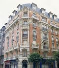 Mansion house built in 1900
 -
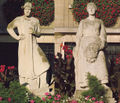 La Jardinière et l'Ouvrier (1944)
 -
 Flyer for a festival of Gypsy jazz representing Django Reinhardt


- Current plannings and developments:
Transportation: plans to improve quick connections to the other suburbs as well as the connections from Paris to non-central areas in Montreuil.
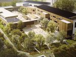
Housing: projects of new habitation on the free place of the "coeur de ville", renovation plans for the buildings of the 50s-70s, opening of kindergarten
Commercial: creation of a commercial center for the quarter ""coeur de ville"
- widths="150px"
-
 Project of extension of public transportation in Montreuil
 -
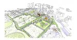
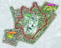 Plan for the project "coeur de ville"


Analytical drawings
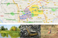
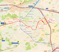
To analyse the potential of this square to become a green infrastructure, it is necessary to consider the city as part of a bigger urban area in the metropolis of Paris.
-
 Territorial analysis of Montreuil in the region "Ile-de-France"

This first overview shows an undeneable potential because of the good territorial connections but it represents also a threat for the development of wildlife corridors in the region. The quarter "coeur de ville", being situated in a row of parcs and open spaces, beginning in Paris and directed to Natura 2000 protected areas as well as regional parcs of the country side, has the potential to become a milestone to improve ecosystems connectivity.
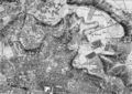
The following analytical drawing shows on a section the function of the square in the landscape of the city.
-
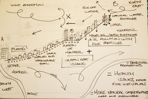 Geographical analysis of the site

It reveals conflicts between anterior big construction projects and circulation of fresh air comming from the ocean through the Seine valley or between natural topography and the use of soil (buildings, sealed surfaces) causing a heat urban island effect on the plateau and the hills and floods in the cuve. Important human activities bring other problems like emissions, light and noise pollution.
This activities and the pedestrian/public traffic confere to the square a high frequentation quote. The following layer analysis shows the diverse features of the life around the city hall.
-
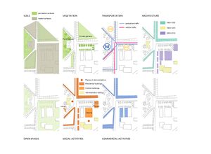 Layer analysis

This rich range of activities is a good basis for a multifunctional use of this place. The connectivity of open spaces on the administrative island should be seen as a starting point for the creation of a network of open spaces supporting the connectivity of ecosystems for birds and insects. This can not work succesfuly without improvibg the permeability of soils and the quality and quantity of vegetation considering the limits that represents transportation ways.
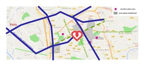
In order to resume the important points for a green infrastructure strategy in the "coeur de ville" a SWOT analysis can show the potential and riscs of such a project.
-
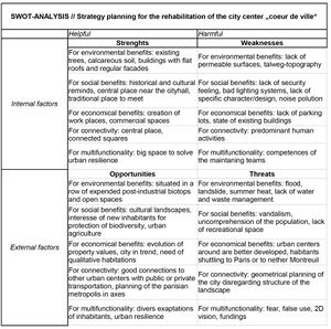 SWOT-analysis for the rehabilitation of the city center

Green Infrastructure benefits for this site
Benefits to the environment: improvment of the urban biodiversity, creation of corridors for wildlife, fight against climate change, air, noise and light pollution...
Benefits to social cohesion: improvment of health through improvment of air quality, encouragment of physical activities in open spaces, creation of recreation spaces for children eductation, restoration of contact with nature, awarness for environmental issues...
Benefits to the economical strategy: improvment of the quality of residential buildings, of property values, creation of green jobs, devlopment of tourism...
Potential for multifunctionality
Green infrastructure has typically multiple functions. What could be achieved for your site in this respect?
-
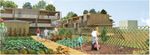
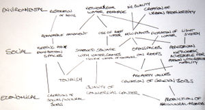 Ideas for multifunctionality

Projective drawings
- How would you like this case to change in the near future? (in 1-2 years)
- you may add a short explanation here
- And how could it look like in 10-15 years?
- you may add a short explanation here
- Projective Drawings
-
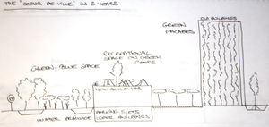 The "coeur de ville" in 2 years
 -
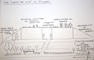 The "coeur de ville" in 15 years


Summary and conclusion
Former experiences showed that it is difficult to create social cohesion around culture and history in Montreuil because of the diversity of the population. Green infrastructure because of their multifunctions could create this cohesion around environmental protection or economical activities. The Rehabilitation of this square should not bring mono-functional residential buildings. Even if quality standards have evolved the buildings constructed on the border of the square near the street with no private outdoors will not fill the expectations of the new inhabitants. The mixed use (residential, commercial and cultural) on the relative little place will bring conflicts that green infrastructure could solve working on multifunctional design and connectivity of open spaces. Some subjects are also in trend in the population, for example, urban agriculture should also be involved in the planning. On a long therm the use of human power to produce energy could bring meaning to the high frequentation of this place that is gone become the home of many families.
Image Gallery
- History of Montreuil
-
-
-
-


- Architectural inheritance
-
-
-
-
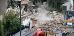


- Social difficulties in Montreuil
-
-

-

-


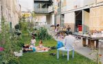
- Green projects in Montreuil
-
-
-
-


References
- please add your references here
About categories: You can add more categories with this tag: "", add your categories