Green Infrastructure 2014 Group E - Case Study 2
---> back to group page working group E
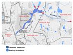
Living with water In the urban landscape of Dhaka
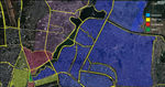
| Name | Undeveloped water bodies around Hatirjeel(Rampura khal) | |||||||||||
| Country | Bangladesh | |||||||||||
| City | Dhaka | |||||||||||
| Authors | Mansura Perveen | |||||||||||

| ||||||||||||
| {{#widget:GoogleMaps | width=300 | height=240 | lat=23.750489 | lng=90.396644 | zoom=13 | centermarker=yes | maptypecontrol=yes | overviewmapcontrol=yes | largemapcontrol=yes | scalecontrol=yes
}} | ||
Rationale: Why is this case interesting?
Once upon a time, not too long ago, Dhaka was crisscrossed with numerous water bodies. Those water bodies acted as a great asset for the city; the city worked and lived with the water. However, over the years, as the population of the city increased manifold, these beautiful wetlands began to diminish from land filling, encroachment, dumping of waste etc. Hatirjheel was one of these many water bodies. It became a dirty, negative space for the city. At one point the government did realize the importance of reviving these dead water bodies. A major development project was undertaken for Hatirjheel with peripheral roads, bridges, overpass, improved drainage and storm water retention. But it turned out to be more gray and less green than expected, and it failed to capitalize on the original hydrological and ecological cycles. It would be interesting to apply Green Infrastructure Ideas to the development of other water bodies nearby, with an attempt to overcome similar shortcomings.
Author's perspective
I was born and brought up in the city of Dhaka. I recieved my Bachelor of Architecture degree from a local school. I remember visiting my relatives who lived in the vicinity of the site in my childhood. During the early 90s, the water body was very clean and resourceful with a rich flora and fauna, and hosted a variety of activities. I have some very fond memories from my childhood at those places. Very recently some major infrastructure development was carried out, in this area. But even with all these improvements the site seems under-utilized as it failed to restore the previous diversity of the habitat. I thought it would be very interesting to try for innovative green solutions for the adjacent water canals that awaits similar development.
Landscape and/or urban context of your case
Geography

Bangladesh is a riverine country located on a deltaic plain in South Asia. The landscape mostly consists of a low-lying plain. The confluence of the Ganges (Padma), Brahmaputra (Jamuna), and Meghna Rivers and their tributaries, makes Bangladesh's alluvial soil highly fertile, but vulnerable to flood and drought.
Roughly 80% of the landmass is made up of this fertile lowland which has an elevation of less than 10 meters above sea level. About 10,000 square kilometers of the total area of Bangladesh is covered with water, and larger areas are routinely flooded during the monsoon season. About 67% of Bangladesh's nonurban land is arable.
Climate


Bangladesh has a tropical monsoon climate characterized by wide seasonal variations in rainfall, high temperatures, and high humidity. Regional climatic differences in this flat country are minor. There are six different seasons in Bangladesh: Summer (Grishma), Rainy Season (Barsha), Autumn (Sharat), Dewy Season (Hemanta), Winter (Sheet) and Spring (Bashanta).
Heavy Monsoon rainfall is characteristic of Bangladesh causing it to flood every year. Most parts of the country receive at least 2,300 mm (90.6 in) of rainfall per year. About 80% of Bangladesh's rain falls during the monsoon season. The monsoons result from the contrasts between low and high air pressure areas that result from differential heating of land and water.
The variation of rainfall between the rainy season and the winter causes an average difference of 2 meters in the water level.
Dhaka
Dhaka, the capital city of Bangladesh lies near the tropic of cancer, at the geographic co ordinates of 24 00 N 90 00 E. Like the country itself; the city also is a birth child of water. Dhaka holds a population of 15 million which makes it the world’s 9th largest mega-city. All these people live in just 325 square kilometers; at more than 45,000 people per square kilometer. It is therefore the most densely populated city of the world. The city was once famous for its landscape of lush green and blue water. But a whirlpool of concrete, dust, fume and growing number of heads turned the blue-green image into a monotonous grey.

- History and Development of Dhaka
Dhaka is an almost 400 year old city. Historically, the development of Dhaka City started in Pre-Mughal period (before 1605) from the southern part, on the banks of Buriganga River. It then extended towards the west and north during the Mughal (1608 to 1764) and British period (1764 to 1947)
During the first part of the colonial period (1764 to 1857), under the rule of East India Company, Dhaka experienced a sixty-year period of disorder, unrest and political instability. They shifted the capital of Bengal to Kolkata, and exploited the country to provide raw materials for their home industries, with little regard for its development. Thus, the commercial activities of Dhaka were greatly reduced and it almost became a deserted city. During the later part of the colonial period (1858 to 1947), Dhaka went through vast physical changes. The British carried out huge infrastructure developments in Dhaka. Although it was done without a definite plan, it transformed Dhaka from a medieval Indian city to a modern city. In 1905, Bengal was divided and Dhaka was chosen as the capital of East Bengal, prompting further rapid development of the city.
In 1947, Dhaka became the provincial capital of East Pakistan. The influx of migrants following the partition resulted in a 103% increase in population. To accommodate the increasing administrative, commercial and residential need the city underwent a rapid and massive growth. During Pakistan period (1947-1971), the development advanced primarily toward the north and it continued rapidly and in an unplanned way toward all sides of the city. The city expanded, at first spontaneously, but later in 1956, the Dhaka Improvement Trust (DIT) was formed by the government and subsequently some planned development was carried out.
After the independence of Bangladesh in 1971, Dhaka became the most important and influential center of all national activities. Lack of serious initiatives to develop a planned city along with an extensive rural to urban migration resulted in a rapid and uncontrolled growth of the city. The growth caused many low lands to be filled up and all the low lying areas on the eastern and western sides came under occupation. With the rise of population pressure, the highlands spreading towards the north came to be occupied. No serious efforts has been undertaken to create a planned city and Dhaka has now been growing by its own demand.
- cultural features, overall character, history and dynamics


- Illustrations: maps; sketches; short descriptive analyses
- Illustrations
-
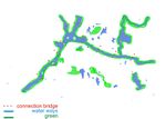
 landuse
 -
your visual
-
your visual

Analytical drawings
- Please use analytical drawing for visualising the conflicts/potentials of your site
- Analytical Drawings
-
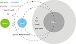 concept diagram
 -
 Distant Past
 -
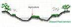 Distant Past Winter
 -
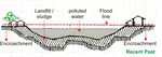 Recent Past
 -
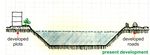 present
 -
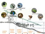 Wetland habitat (birds)
 -
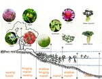 Wetland habitat (Floras)


Green Infrastructure benefits for this site
Environmental Benefits
Preservation of local habitat
Green Infrastructure can attempt to restore the original ecological cycle at the site by regenerating living processes and integrating it with man-made structures.
Retaining storm-water
It can reduce storm-water runoff volumes by utilizing the natural retention and absorption capabilities of vegetation and soils.
Enhanced Groundwater Recharge
The natural infiltration capabilities of green infrastructure technologies can improve the rate at which groundwater aquifers are recharged. Enhanced groundwater recharge can also boost the supply of drinking water.
Improved Water Quality
Green Infrastructure techniques infiltrate runoff close to its source and help prevent pollutants from being transported to nearby surface waters.
Improved Air Quality
Green infrastructure facilitates the incorporation of trees and vegetation in urban landscape, which can contribute to improved air quality.
Increased Carbon Sequestration
The plants and soils that are part of the green infrastructure will serve as sources of sequesting carbon.
Urban Heat Island Mitigation and Reduced Energy Demands
By providing increased amounts of urban green space and vegetation, green infrastructure can help mitigate the effects of urban heat islands and reduce energy demands.
Social Benefits
Creating Recreational Space
Green Infrastructure can improve the life and living of the inhabitants by providing recreational spaces in the form of greenways, parks, urban forests, wetlands etc. This is more true for this site as it was being treated as a dumping back-yard; and also because there is an acute shortage of land in this densely populated city of Dhaka.
Improved sense of community
By increasing access to places for gathering and interacting, Green Infrastructure can boost the sense of belongingness, sense of community among the people. This can be improved to a better extent if the people can participate in the management and maintenance.
Improved Aesthetic Quality
Green Infrastructure can greatly improve the aesthetic quality of the site.
Improved Public Health
With improved environmental and aesthetic quality, reduced pollution, places for exercising activities; Green Infrastructure can imrove the physical, mental and spiritual health of the people.
Economic Benefits
Cost Effective
Green Infrastructure is cost effective as it requires less capital investment and maintenance cost. It can also lessen the associated wastewater pumping and treatment cost.
Reduced Transport cost
Waterways can be an economically efficient and energy-saving mode of transport.
Income Generating Potentials
Income can be generated from various recreation facilities; like boating, fishing etc. Yields from local agriculture can generate income too.
Other economic benefits
Reduced energy consumption and health care cost can be considered as economic benefits.
Potential for multifunctionality
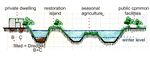
Waterway (Aquatic Zone)
Apart from heavily improving the water retention capacity and flood control an well maintained waterway can also contribute as recreational space. It can augment the city transportation by promoting waterway transportation which can be cheaper, more energy efficient and convenient. It could really take a huge traffic load off the city roads, if the diminished connections between different water bodies of the city were restored.
Edge (Riperian Zone)
Apart from playing a major role in restoring and preserving the ecological cycle of the site by providing habitat for different flora and fauna, the soft edge can help to reduce water pollution by filtration. It can even be used for planned agriculture.
Greenway (Upland Zone)
The green surfaces and vegetation sequesters carbon, and fights against the impacts of climate change. Apart from reducing pollution and enhancing groundwater table recharge, the greenery can create pleasant spaces for social gathering and recreation. The land area that only remains above the water level in dry season can also be used for seasonal agriculture.
All of them can contribute, in their own way, to:
• Improving the aesthetic quality of the site
• Improving the public health of the inhabitants
• Reducing demands and consumption of energy
• Mitigating climate change & heat-island effect
• Generating income in various ways
Projective drawings
- How would you like this case to change in the near future? (in 1-2 years)
- you may add a short explanation here
- And how could it look like in 10-15 years?
- you may add a short explanation here
- Projective Drawings
-
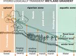 soft edge gradient
 -
 Short-term projection
 -
 Long-term projection
 -
 vision


Summary and conclusion
- 100 words approx.
Image Gallery
Please add further images/photos here
- Image Gallery
-
your image text
-
your image text
-
your image text
-
your image text
-
your image text
-
your image text
-
your image text
-
your image text
References
- please add your references here
About categories: You can add more categories with this tag: "", add your categories