Green Infrastructure 2014 Group C - Case Study 2
---> back to group page working group C
Shahar chay,(Urmia/Iran) , Challenges, Actions and suggestions
| Name | Shahar chay,(Urmia/Iran) | |||||||||||
| Country | Iran | |||||||||||
| City | Urmia | |||||||||||
| Authors | Bahman Nahri | |||||||||||

| ||||||||||||
| {{#widget:GoogleMaps | width=300 | height=240 | lat=37.535321 | lng=45.076984 | zoom=14 | centermarker=yes | maptypecontrol=yes | overviewmapcontrol=yes | largemapcontrol=yes | scalecontrol=yes
}} | ||
Rationale: Why is this case interesting?
The river Shahar chay(Figure 3) is one of the most important 13 rivers that ends up in Urmia lake and flows from south-west to east of the city and passes through the city, and gives a wonderful view to the city and of course one of the determinant elements to landscape-architecture. Fortunately, most of the river coast was built by government and has a nice view but some parts are still untouched (figure 7) and can be designed to increase green/blue places all along the city, while the population of Urmia is increasing every day and we need more green place to play and recreation, but most important thing is the irrigation problem and the drainage problem of river and consequently dying of the Urmia Lake. Lake Urmia (LU) is a vast lake in NW Iran, shared between the provinces of East and West Azerbaijan. The Urmia lake is a National Park, the largest inland lake in Iran and the largest lake in middle east. The Lake is surrounded by a number of important fresh-brackish water satellite wetlands, several of which are also of global significance for their biodiversity. Also the Lake includes several islands that provide important habitats for birds and mammals. But in just 14 years it has almost vanished. Once covering 5000 square kilometers, by October last year it covered just 20 percent of that. It's volume has shrunk nearly 95 percent from it's original 32 cubic kilometers.
The southern half of the lake has been left largely dry, and wildlife has suffered. Flamingos largely abandoned islands in the lake where they bred, and numbers of migratory ducks, shorebirds and gulls declined.
The problem is that Lake Urmia is highly vulnerable to water loss. Like the shrunken Aral Sea in central Asia, it is shallow and sits in a closed, semi-arid basin. Every year about 3 billion cubic metres of water evaporates from the lake.
It looks like that situation could now change.
There is 13 rivers that flow to Lake Urmia.
| Num. | Name | Length | Dam | Origin |
|---|---|---|---|---|
| 1 | Aji Chay | 265 | yes | east azarbayjan |
| 2 | Alamlou River | -- | -- | -- |
| 3 | Barandouz River | 76 km | yes | west azarbayjan |
| 4 | Gadar River | 100 km | yes | Iranian Zagros Mountains |
| 5 | Ghaie River | -- | -- | -- |
| 6 | Leylan River | -- | No | Kurdistan |
| 7 | Mahabad River | -- | yes | kurdistan |
| 8 | Nazlou River | -- | yes | Turkey |
| 9 | Rozeh River | -- | -- | -- |
| 10 | Shahar River | 180 km | yes | Turkey |
| 11 | Simineh River | 200 km | yes | kurdistan Iraq |
| 12 | Zarrineh River | 302 km | yes | kurdistan |
| 13 | Zola River | 230 | yes | west azarbayjan |

Debi of riiver flow
Author's perspective
Urmia is the capital of West Azerbaijan Province, and located along the shahar chay river ( city river ) on the city plain. the river plays important role in aesthetic aspect of the city but because of the Shahar chay dam (Figure 1&2), it does drains some seasons of the year. Lake Urmia lies to the east of the city with the mountainous Turkish border to the west and the lake suffers the same problem of drainage. The most important thing that I like about this site is: The water and green elements are together and can be well utilized and organized to propose the city a good look, and as far as the population and traffic is increasing day to day so we need more green place to reduce pollution and create a place for people to spend their leisure time there.
Landscape and/or urban context of your case
- History
Urmia is one of the historic ancient cities in Iran with Assyrian roots.[citation needed] The excavations of the ancient ruins near Urmia led to the discovery of utensils that date back to 2000 years B.C.. According to Vladimir Minorsky, there have been villages in the Urmia plain some 2000 years B.C., with their civilization under the influence of Van nation. In the ancient times, the west bank of Urmia lake was called Gilzan, and in the ninth century B.C. an independent government ruled there which later joined the Urartu or Mana empire; in the eighth century B.C., the area was a vassal of the Asuzh government until it joined the Median Empire after its formation. All and all, according to historical documents, the western part of the Urmia Lake has been a center of attention of the prehistoric nations, the evidence of which are the numerous ancient hills in the area, such as Gouy Tapeh, 6 km (3.7 mi) southeast of the lake which competes with the oldest hills of Mesopotamia, Asia the Minor, and the Iranian Plateau. The claim that the area was the birthplace of Zoroaster (also called Zarahustra) is disputed because most experts agree Zoroaster was most likely born in the eastern part of Greater Iran, or even the burial site of one or two of the Zoroastrian priests who allegedly traveled to Bethlehem for Christ’s birth indicate that the city has been one of the largest religious and scientific centers of the ancient times.
The Columbia Encyclopedia mentions that Urmia was an important town in the region during the 9th century.
The Ottoman Turks made several incursions into the city, but the Safavids were soon able to regain control over the area. The first monarch of Iran's Qajar dynasty, Agha Muhammad Khan, was crowned in Urmia in 1795. Due to the presence of substantial Christian minority at the end of the 19th century, Urmia was also chosen as a site of the first American Christian mission in Iran in 1835. Another mission soon became operational in nearby Tabriz as well. During World War I the population was estimated as 30,000 by Dr. Caujole, a quarter were Assyrians and 1,000 were Jews. During the 19th century, the region became the center of a short lived Assyrian renaissance with many books and newspapers being published in Syriac. Urmia was also the seat of a Chaldean diocese.
At the beginning of the First World War tens of thousands of Assyrians and Armenians from Anatolia found refuge in Urmia. The city changed hands several times between Russians and Kurds the following two years.The influx of Christian refugees and their alliance with the Russians angered the Muslims who attacked the Christian quarter in February 1918, The better armed Assyrians managed however to capture the whole city following a brief battle.The region descended into chaos again after the assassination of the Assyrian patriarch Shimun XXI Benyamin at the hands of Simko Shikak one month later. Turkish armies and Samko managed to finally take and plunder the city in June/July 1918.Thousands of Assyrians were massacred, others found refuge under British protection in Iraq.
Urmia city history Urmia is one of the historic ancient cities in Iran with Assyrian roots.[citation needed] The excavations of the ancient ruins near Urmia led to the discovery of utensils that date back to 2000 years B.C.. According to Vladimir Minorsky, there have been villages in the Urmia plain some 2000 years B.C., with their civilization under the influence of Van nation. In the ancient times, the west bank of Urmia lake was called Gilzan, and in the ninth century B.C. an independent government ruled there which later joined the Urartu or Mana empire; in the eighth century B.C., the area was a vassal of the Asuzh government until it joined the Median Empire after its formation. All and all, according to historical documents, the western part of the Urmia Lake has been a center of attention of the prehistoric nations, the evidence of which are the numerous ancient hills in the area, such as Gouy Tapeh, 6 km (3.7 mi) southeast of the lake which competes with the oldest hills of Mesopotamia, Asia the Minor, and the Iranian Plateau. The claim that the area was the birthplace of Zoroaster (also called Zarahustra) is disputed because most experts agree Zoroaster was most likely born in the eastern part of Greater Iran, or even the burial site of one or two of the Zoroastrian priests who allegedly traveled to Bethlehem for Christ’s birth indicate that the city has been one of the largest religious and scientific centers of the ancient times.
The Columbia Encyclopedia mentions that Urmia was an important town in the region during the 9th century.
The Ottoman Turks made several incursions into the city, but the Safavids were soon able to regain control over the area. The first monarch of Iran's Qajar dynasty, Agha Muhammad Khan, was crowned in Urmia in 1795. Due to the presence of substantial Christian minority at the end of the 19th century, Urmia was also chosen as a site of the first American Christian mission in Iran in 1835. Another mission soon became operational in nearby Tabriz as well. During World War I the population was estimated as 30,000 by Dr. Caujole, a quarter were Assyrians and 1,000 were Jews. During the 19th century, the region became the center of a short lived Assyrian renaissance with many books and newspapers being published in Syriac. Urmia was also the seat of a Chaldean diocese.
At the beginning of the First World War tens of thousands of Assyrians and Armenians from Anatolia found refuge in Urmia. The city changed hands several times between Russians and Kurds the following two years.The influx of Christian refugees and their alliance with the Russians angered the Muslims who attacked the Christian quarter in February 1918, The better armed Assyrians managed however to capture the whole city following a brief battle.The region descended into chaos again after the assassination of the Assyrian patriarch Shimun XXI Benyamin at the hands of Simko Shikak one month later. Turkish armies and Samko managed to finally take and plunder the city in June/July 1918.Thousands of Assyrians were massacred, others found refuge under British protection in Iraq.
- Geography and Climate
The climate of the province is largely influenced by the rainy winds of the Atlantic Ocean and Mediterranean. Cold northern winds affect the province during winter and cause heavy snow. According to existing meteorological data, local temperatures vary within the province. Average temperature differs from 9.4 °C in Piranshahr to 11.6 °C in Mahabad, while it is 9.8 °C in Urmia, 10.8 °C in Khoy, 9.4 °C in Piranshahr, and in Mahabad 11.6 °C. According to same data, the highest temperature in the province reaches 34 °C in July, and the lowest temperature is –16 °C in January. Maximum change of temperature in summer is 4 °C, and in winter 15 °C. West- Azarbayjan province, encompassing vast and fertile plains, high mountains, enjoying moderate and healthy weather, rivers with high volume of water, vineyards, orchards, luxuriant forest and rangelands, mountain outskirt with wonderful flora, magnificent wildlife and beautiful shores around the lake with different recreational facilities, which all together form one of the most beautiful and spectacular region in Iran. A land with wonderful flora during the spring and the summer covered with tulip, poppy, narcissus and hyacinth extending from Arass rivers banks in the north to Zab Kouchak valley in the south. Urmia's climate is semi-arid (Koppen BSk) with moderately cold winters, mild springs, hot, dry summers (though mild for Iran) and crisp autumns. Precipitation is heavily concentrated in late autumn, winter, and especially spring, while summer precipitation is very scarce.
As I mentioned in the beginning of the essay, there are 13 rivers that flow to Urmia lake and all of them are barriered with dams, the most important reason of the Lake drainage is building dams without any scientific study, and the Lake drainage has a lot of Impacts:
As lake levels decline, the exposed lake bed is left with a covering of salts, primarily sodium chloride, making a great salty desert on much of the 400 km² of lost surface area. These salt flats will not support agriculture and inhibit growth of most natural vegetation. The salts are also susceptible to blowing and will likely create "salt-storms" like the ones that have resulted from the drying of the Aral Sea, located 1200 km to the northeast of Lake Urmia. Blowing salts from the Aral Sea have been linked to vegetation-mortality in some cases or, more frequently, reduced vegetation growth, reduced crop yields, ill effects on wild and domestic animals, respiratory illness, eye problems, and throat and esophageal cancer. Based on the experience of the Aral Sea salt storms, it is likely that many of the tens of millions of people who live within a few hundred kilometers of the lake will be close enough to experience the impact of these salt storms.(Figure 5)
- Biogeography, cultural features, overall character, history and dynamics
- Illustrations: maps; sketches; short descriptive analyses
- Illustrations
-
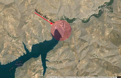 shahar chay dam satelite map (Figure 1)
 -
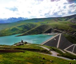 shahar chay dam (Figure 2)
 -
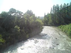
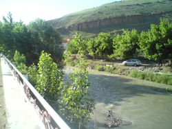 shahar chay river (Figure 3)
 -
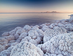 Salt covered stones (Figure 4)
 -
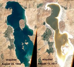 Urmia Lake during 13 years (Figure 5)
 -
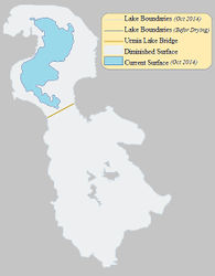 Lake drainage level (Figure 6)
 -
 untouched places band village(Figure 7)


Analytical drawings
- Please use analytical drawing for visualising the conflicts/potentials of your site
- Analytical Drawings
-
 The site neighborhood
 -
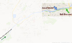 The area of interest
 -
your drawing
-
your drawing


Green Infrastructure benefits for this site
- Environmental Benefits
1- People would prefer to walk or bike through the river, rather than using their cars, so that there would be less air pollution.
2- Also It can derogate air pollution by reducing fossil fuel emissions from vehicles, lessening energy consumption by buildings and sequestering and storing carbon. It can improve the environment quality by removing harmful pollutants from the air and water.
3- Green Infrastructure can restore or even preserve natural ecosystems not only for the river, but also for Urmia Lake.
- Economic Benefits
1- Green structure in this area can create job and business opportunities in fields such as landscape management, recreation.
2- It can reduce energy, healthcare, and grey infrastructure cost, making more funds available for other purposes.
- Social Benefits
1- Green Infrastructure promotes healthy society by providing outdoor sport and recreation opportunities and enabls people to walk or bike as part of their daily routines. Since I lived in this city for 28 years, I consider this aspect particularly important. The possibility to use the bike is today an essential city living goal. Unfortunately there is no bike road in Urmia. The Shahar chay river side creates a perfect place where develop a bicycle route.
2- creates places for people to gather and communicate socialize.
3- Improves the aesthetic of urban structure.
4- People can sell their agricultural products there, and it can be a good opportunity to have a local trade.
5- It can improve environmental conditions (air quality) and consequently effects public health.
Potential for multifunctionality
We can reach different aims, like recreational spaces proposing different possibilities such as jogging or playing in the park, walking along the river, family picnics,( swimming, fishing, boat riding before dam), Playing Football, Tennis, badminton. There are plenty of cafes and restaurants in and across the park. That can be a revival for the people to escape the noise and the pollution of the city and relax .
Projective drawings
- How would you like this case to change in the near future? (in 1-2 years)
- you may add a short explanation here
- And how could it look like in 10-15 years?
- you may add a short explanation here
- Projective Drawings
-
projective drawing
-
projective drawing
-
projective drawing
-
projective drawing
Summary and conclusion
- 100 words approx.
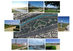
Image Gallery
Please add further images/photos here
- Image Gallery
-
your image text
-
your image text
-
your image text
-
your image text
-
your image text
-
your image text
-
your image text
-
your image text
References
- please add your references here
About categories: You can add more categories with this tag: "", add your categories