Underground Landscapes
---> back to overview of Case Study List
add long title of your theme
| Name | Underground Landscapes, Karlsplatz Station, Munich | |
| Location | Munich | |
| Country | Germany | |
| Authors | Milkana Mladenova, Natalia Vergara | |

| ||
| <googlemap version="0.9" lat="48.140432" lon="11.556244" type="terrain" zoom="11" width="300" height="250">
48.140089, 11.566404, Karlsplatz (Stachus) Karlsplatz (Stachus), Munich, Germany </googlemap> | ||
Short Introduction to the Area of Study
Karlsplatz is one of the busiest stations in Munich as in 2009, 351 million passengers rode the U-Bahn. This is why it is one of the most important landmarks in Munich and therefore an everyday landscape both for locals and tourists. Since its construction in the early 1970s it developed as a “city within the city “. It houses a shopping center, bank, food courts and ticket counters in 5 levels underground, differentiated by color and texture in order to make the experience of the travelers an easier and better one, as well as in above ground it connects to the main tourist’s attractions and the shopping district. Its importance is emphasized by the fact that all public transport lines intersect in this point, making it a very known place by the people that pass through it every single day and somehow do not consider it as “their everyday landscape”.
Exercise 1: Sketching the Landscape
Time frame: October 25 - November 15, 2011
Student activities:
- Creation of analytical drawings and sketches
- Presentation of results
Please upload a selection of your drawings/sketches/mental maps and add them to the image gallery
-
 A waiting place
 -
 Underground Textures
 -
 Everyday paths
 -
 Perception + Everyday Paths + Activities
 -
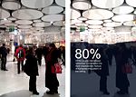
 The first floor's plain white space is made visually interesting through the forms in the ceiling.
 -
 A stop of the S-Bahn after the train passes through- an empty space, even if thousands of people use this stop.
 -
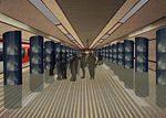
 Karlsplatz underground level 1
 -
 All public transport lines pass through or near Karlsplatz station.
 -
 SBahn
SBahn


Exercise 2: Landscape Layers
Time frame: November 15 - 29, 2011
- time based changes and 'landscape biography', and/or:
- topography, open spaces, built, green, traffic and water structures on different layers. *Definition of zones with coherent character
- Description of this character.
-
 Transport connectivity of Munich
 -
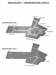 Underground levels at Karlsplatz
 -
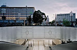
 The renewed in 2007 underground passage at Stachus(Karlsplatz)
 -
 Aerial view and underground mapping of stops for U4 and U5
 -
 Ground Layers "What Meet the eye"
 -
 Layers "Public transportation System"
 -
 Surrounding
 -
Activities, movement patterns, stores and levels inside Karlsplatz Station.
-
 Time Line Karlsplatz


Please publish your findings here
Exercise 3: Behaviour Patterns
Time frame: December 6 - 20, 2011
- How do people behave in this area? How do they use the space? What is important for them?
- Observation of study area, interviews with local people and mapping of use patterns.
- Preparation of short presentation
Please publish your findings here
-
 Ground Level Patterns (How people move)
 -
 Level 1 Inside Patterns
 -
 Level 2 Underground Sbahn Pattern
 -
 Level 2 Underground Ubahn Pattern
 -
 What people remember. (Interviews)
 -
 Examples of Behavior Patterns. (Interviews)
 -
 Most visited places according to people in the area. As preferred way of transportation between the levels most people chose the elevators or escalators. As a reason they point out the busy everyday life. The least used are the stairs.
 -
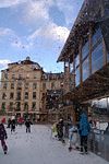
 One of the main attractions for visitors during the winter - the Christmas market and ice-skating ground. Image as seen on : http://v2.cache5.c.bigcache.googleapis.com/static.panoramio.com/photos/original/17893151.jpg?ir=1&redirect_counter=1
 -
 Visitors' behavior defined by the main points of interest around Karlsplatz.
 -
 Mapping Social Activity


Exercise 4: Communication Concepts
Time frame: December 19, 2011 - January 17, 2012
- Based on the different landscape assessment approaches students will develop a communication concept for their area of study
- Which measures would be necessary for enhancing the awareness for the area?
- Students are free to choose their method.
-
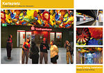
 Underground Landscapes - Karlsplatz
 -
 Designs by H. Barragan - VIDEO http://www.youtube.com/watch?v=VRh8feHS0pM&feature=results_main&playnext=1&list=PLFA275C0ED69EC4F0
 -
 Designs by D. Chihuly - http://www.chihuly.com/hotshop-under-the-persian-ceiling_detail.aspx
 -
your image text
-
your image text


Hernando Barragán interactive art, Video <videoflash>VRh8feHS0pM&feature=youtu.be</videoflash>
Please publish your findings here
Image Gallery
-
 Underground Level 1. Inside Picture.
 -
 Ground Level Karlsplatz
 -
 Ground Level Karlsplatz - Ice Skating Area
 -
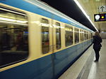
 Level 2. S Bahn Inside Picture.
 -
 Level 2. S Bahn Inside Picture.
 -
 Underground Level 3. U Bahn Inside Picture.
 -
 Underground Level 3. U Bahn
 -
 Stop decoration
 -
 Stachus Passage


References
Images used: http://v2.cache5.c.bigcache.googleapis.com/static.panoramio.com/photos/original/17893151.jpg?ir=1&redirect_counter=1 http://www.panoramio.com/photo/45906610 http://www.panoramio.com/photo/18742915 http://www.panoramio.com/photo/53075831 http://www.panoramio.com/photo/37937746 http://www.panoramio.com/photo/45208972 http://www.panoramio.com/photo/63211270
About categories: You can add more categories with this tag: "", add your categories