Group M - Collaborative Climate Adaption Project
| Area | Torres Strait Islands | |||||||||||
| Place | Iama Island | |||||||||||
| Country | Australia | |||||||||||
| Topic | Sea level rise | |||||||||||
| Author(s) | James Nash, Aura Istrate, Janice Thien | |||||||||||

| ||||||||||||
| {{#widget:GoogleMaps | width=300 | height=200 | lat=-10.47 | lng=142.25 | zoom=11 | centermarker=yes | maptypecontrol=yes | overviewmapcontrol=yes | largemapcontrol=yes | scalecontrol=yes
}} | ||
Rationale: Why have you selected this case study area?
- Please summarise:- e.g. previous experience, is it your everyday environment?, specific vulnerability, previous research being done etc.
We have selected this area out of our concern for those who will feel the affects of climate change first, and are representative of those who may endure the most significant impacts of climate change and sea level rise. For our project focus, we have selected an island known as Iama or Yam island. It is a part of the Torres Strait, an archipelago of islands between the Northern tip of Australia and Papua New Guinea. Politically, the islands are a part of Australia, however they are culturally distinct being a traditional Pacific Islander culture, with strong links to the traditional cultures of northern Australia and Papua New Guinea. The islanders have a specific vulnerability to climate change being a strongly sea based culture and living very much between the sea and the land. Subtle changes in sea levels and oceanic conditions (such as acidification) will have large and far reaching impacts into the islanders life, cultural orientation and livelihoods that will only become more pronounced as these changes become more drastic. Climate change may also bring more severe storm conditions via larger cyclonic tropical depressions. The communities of the Torres Strait, as indigenous people of these islands, face a host of issues concerning sovereignty and ownership rights of land due to Australian Government Policy. In addition Torres Strait Community members are significantly affected by conditions of Diabeties and Heart Disease attributed to the uptake of Western dietary choices over Traditional foods. We are particularly interested in this area as a program of adaption to climate change could have a "No Regrets" approach of also improving the preexisting health and land rights policy conditions faced by islanders. There has been some significant research into the impacts of climate change on the Torres Strait, including our project focus area of Iama Island. This research is ongoing however much of the work is predominantly taken from the perspective of setting minimum building floor levels and providing engineered infrastructure such as Sea Walls. Whilst these are significant foundations, we believe an approach from Landscape Architecture that considers settlement patterns, cultural and physical wellbeing will provide a more thorough approach towards a continuing, resilient Torres Strait Island Culture. Members of our group have had experience in strategising for Sea level rise and local experience of working in the Torres Strait.
Authors' perspectives
- What theoretical or professional perspective do you bring to the case study?
We will bring the perspective of cultural inclusiveness. We believe that the best way to work with cultures older than our own is to ask, listen, observe, learn- be guided by cultural knowledge, and then propose ideas. We will seek to understand existing regionally specific research into the effects of climate change in the Torres Strait, both widely, and on our specific project location. We will also seek to gain as much traditional knowledge about food production and harvesting technologies, transport patterns and navigation, settlement patterns and building technologies, and traditional systems of organising and local governance. We understand that much harm and damage has occured in Australian Indigenous communities through well intentioned, yet misguided development projects and we aim to take a different approach- allowing community cultural based patterns take precedence over proposals from architectural, engineering or policy based development. We believe Proposals through Landscape Architectural based practice may meet the challenge of collaborating between the adaption imperatives of new climate science and the traditional ways and context of islander culture.
Landscape and/or urban context
- Biogeography, land use patterns, cultural features, overall character, history and dynamics
- ratio of green/blue and sealed/built-up areas
The Torres Strait islands (TSI) were formed through mostly volcanic activity that formed the original landscapes of Northern Australia and Papua New Guinea (PNG). The Islands were originally a land bridge between PNG and Australia and over time, from erosive pressures of oceanic tidal currents, and previous changes in Sea levels, what was land, became sea and reef. Interestingly, Torres Strait Islands has been formed most noticeably through changes in sea level rise following the last ice age. The Island communities are closely related to Melanesia and Papua New Guinean Cultures, with some influence from Northern Australian Aboriginal Culture. They are predominantly a seafaring people, with food, transport, cultural stories, trade and family groups and settlement patterns defined by relationships with the sea. The Tribal cultures of Papua New Guinea and Melanesia appear to have a dominant historical influence on cultural paradigms, however these have evolved into a distinctly regional culture based on the islands. The Torres Strait Islanders have land use patterns both in common with PNG, Pacific Islander Culture and Australian Aboriginal cultures. Food production is both agricultural and hunted or wild harvested, however much food is imported from Australia and now forms a significant part of TSI diets. Settlement patterns are based on village structures by the sea, yet temporary seasonal camps serve food harvesting purposes on either other islands or on more remote parts of settled islands. Settlement patterns now have been heavily influenced by western style housing and suburban settlement patterns, however traditional style improvised shelters for gathering and recreation continue to be constructed and decorated from both traditional and modern reused construction materials. Islands are predominantly bushland with small areas set aside amongst housing for subsistance gardening, which is now practiced less and less. Small urban clusters now occupy small village sites, with larger blocks of housing surrounding the central village areas. Social hubs tend to be around sea ports and wharfs where people launch to the sea, arrive home to meet family or spend time fishing.
Illustration: http://torresstraitclimatedotorg.files.wordpress.com/2011/05/annika_torres-strait-map11.png Map Source: Torres Strait Climate webpage. The Map shows the regional island groups, which islands are occupied and the group of island (including our project location) where islands are predominantly mangrove or coral cays close to sea level.
The Photos above are Sketches made of the islands showing the nature of the landscape and lifestyle of people. They show that the landscape is in the Dry tropics and characterised by rocky volcanic islands , and dry tropic vegetation. Rainforests are found only in small valleys, That inland areas of the islands form seasonal tidal flats with the huge seasonal variation in tides, That traditional seafaring and sea harvesting lifestyles continue and that the perceptions of 'sea and the land' are not as divided as in other cultures.
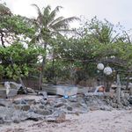
The photos above show photographs of characteristic sea side social spaces made from improvised materials by the islanders.
Cultural/social/political context
- Brief explanation of culture, political economy, legal framework
Illustration: Bullet points, image, background notes
Local Climate
- What are the climatic conditions at present? Have there been extreme weather events in the near past?
- Which changes are expected? Is there any evidence?
Illustration: Table or time line
Analysis of vulnerability
- If you consider these potential changes - which aspects/functions of your case study would be affected?
Illustration: Map/diagram/sketches/photos/background notes
Proposals for Climate Change Adaption
- How could your case study area become more resilient to climate change?
- Which measures would need to be taken to adapt to the new situation?
- How could you assure sustainability of these measures?
- Please describe 2-3 measures
Proposals for Climate Change Mitigation
- Which measures would need to be taken to reduce greenhouse gas emissions and other drivers of climate change within your case study area?
- How could you assure sustainability of these measures?
- Please describe 2-3 measures
Your scenario
- How will this area look like in 2060?
- Please forecast one potential future development taking climate change into account
Illustration: Map/diagram/sketches photos and background notes
What can be generalized from this case study?
- Are there any important theoretical insights?
- Which research questions does it generate?
- Short statement plus background notes
Image Gallery
-
your image text
-
your image text
-
your image text
-
your image text
-
your image text
-
 your image text
 -
your image text
-
your image text

References
Please add literature, documentations and weblinks
About categories: You can add more categories with this tag: "", add your categories