Collaborative Design Planting Design Working Group 18
---> back to group page working group 18
| Name | Gaías hill. Cidade da Cultura Park | |||||||||||
| Location | Santiago de Compostela | |||||||||||
| Country | Galicia - Spain | |||||||||||
| Authors | Aurora | |||||||||||

| ||||||||||||
| {{#widget:GoogleMaps | width=300 | height=200 | lat=42.880485 | lng=-8.54567 | zoom=8 | centermarker=yes | maptypecontrol=yes | overviewmapcontrol=yes | largemapcontrol=yes | scalecontrol=yes
}} | ||
Urban landscape context of your case
URBAN SETTING
Monte Gaiás is one of the hills that shape Santiago de Compostela´s landscape.
Santiago de Compostela is European medium size city, known for being the final destination of the Saint Jacques pilgrimage route. Its historic center was declared Unesco World Heritage in 1985. The urban structure of the city has allowed "nature" and the rural scape to be present in the life of the center of the city.
TOPOGRAPHY AND LAND COVER
The walled historic center was built on a high point surrounded by other hills and two rivers the River Sar and the Sarela. Outside it the city grew from medieval times a long the paths that join the city with other near by towns and rural areas. This allowed the agricultural fields to stay in between the rows of houses till the gates of the town.
Traditional management of land technics still informs the built elements and vegetation of many of the green spaces of the city like this hill. It is an integral part of the city landscape image.
The variety of habitats or association of species allow citizens of this city can enjoy is and integral part of the quality of life of the city.
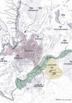
Most of the Monte Gaiás hill is public land with a macro cultural center on its top. It is limited by a Motorway on the East, the Calzada do Sar a historic path that is use by the pilgrims from the South of Spain on the South and West, O Viso village or neighborhood and the Sar riverside urban park on the North.
- Urban contex
-
 Santiago the Compostela as a city with many hills and two rivers
 -
 Monte Gaiás


What are the objectives of your design?
DIVERSITY -Restoring the heathland on Monte Gaiás. Heathlands are dynamic plant communities with a strong cultural and natural value. This type of habitat is uncommon on cities and will help increase cultural, visual and bio diversity in the city.
SUSTANABILITY -Reinterpret the traditional water management of the land reducing the amount of rainwater in the city´s sewage system and bringing water&nutrients back to valley land.
ACCESS -To allow for pedestrian access to the hills side and the Cidade da Cultura.
USE -Introduce new management and new walkways to allow for public access, recreational and educational uses both on the hillside and the Cidade da Cultura open spaces.
Analytical drawings
Please add four analytical sketches/drawings (or montages/schemes) of your case. Every group member needs to contribute at least one drawing.
- Analytical Drawings
-
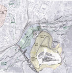
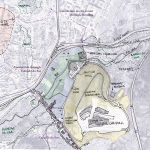 plan showing access from the city center and Monte Gaiás limits
 -
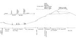 Section explaining the ecological relationships from Monte Gaiás to River Sar


Projective drawings
Please add four projective sketches/drawings (or montages/schemes), of course with an emphasis on planting design/vegetation aspects. Every group member needs to contribute at least one drawing representing his/her individual ideas.
- Projective Drawings
-
projective drawing 1
-
projective drawing 2
-
projective drawing 3
-
projective drawing 4
Design Synthesis
Please analyse the individual approaches presented so far and evaluate their strengths and weaknesses (you may use the SWOTanalysis model). Try to create a synthesis and represent it with a plan and some sketches. You can still use drawings/sketches.
- Design Synthesis Drawings
-
synthesis drawing 1
-
synthesis drawing 2
-
synthesis drawing 3
-
synthesis drawing 4
Summary of the collaborative process
Please reflect on your collaborative design process. Which potentials have you encountered? What was most difficult? What does collaborative design mean for you? (approx 150 words).
Image Gallery
You may add a series of images/photos in addition to the sketches/drawings
- Image Gallery
-
image 1
-
image 2
-
image 3
-
image 4
References
* Please make sure that you give proper references of all external resources used.
* Do not use images of which you do not hold the copyright.
* Please add internet links to other resources if necessary.
About categories: You can add more categories with this tag: "", add your categories