Collaborative Green Infrastructure Design Group C: Difference between revisions
| Line 337: | Line 337: | ||
== Summary of the collaborative process == | == Summary of the collaborative process == | ||
| Line 349: | Line 348: | ||
SHARING: During the working process we get closed and learned about each other. Different levels and working experiences of the members caused an intensive communication how to deal with it. We think for all of us it was a good experience to share how to work, design, think about it in different ways and learn from each other. | SHARING: During the working process we get closed and learned about each other. Different levels and working experiences of the members caused an intensive communication how to deal with it. We think for all of us it was a good experience to share how to work, design, think about it in different ways and learn from each other. | ||
== References == | == References == | ||
Latest revision as of 21:39, 26 January 2015
---> back to group page working group C
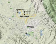
Green/Blue Infrastructure of the urban area of the river of Tirana, ALBANIA
| Name | Green/blue infrastructure in north of Tirana | |||||||||||
| Country | Albania | |||||||||||
| City | Tirana | |||||||||||
| Authors | Mirsa Gishti, Bahman Nahri, Nataly Montoya, Paulina Nickl | |||||||||||

| ||||||||||||
| {{#widget:GoogleMaps | width=400 | height=200 | lat=41.35058978679405 | lng=19.803779075305215 | zoom=13 | centermarker=yes | maptypecontrol=yes | overviewmapcontrol=yes | largemapcontrol=yes | scalecontrol=yes
}} | ||
Rationale: Blue/green infrstructure-connecting the historic centre with the national park
The river of Tirana is located between the historic centre and the National Park of the Paskuqani in northern part of the city. It is one of the 5 developing poles of the multicentric masterplan of the city approved in 2012. The population is expeted to increase during the next years, according to the demographic data and this fact makes the river`s zone a potential area of high density and multifunctionality in the future. The landscape is shaped mostly by natural and seminatural features like hills, the river and the park. Currently informal buildings, waste pollution and low mantainance of ecologic environment has become a very big problem to solve. It is an emergency to approach the future development of the area based on a well integrated green/blue infrastructure project since nothing has been done in this aspect and planning is always a better choice than improving when is too late.
Landscape and/or urban context of your case
- Biogeography, cultural features, overall character, history and dynamics
Overview of the city
Tirana, the capital of Albania, is situated 40 kilometers from Durres, the largest port in the country and 26 km from Mother Theresa International Airport. It is the largest city, with an increasing population, with an average annual growth rate of 3.77% from 2001–2009 (INSTAT, 2009). The faster urbanization influences the city's development, the living environment and the socioeconomic situation.Tirana has the opportunity to be regenerated itself after a long term of isolation. Exists a lot of informality in the northpart of the city, but this informality is supposed to be the shelter for those persons who live there.

Biogeography of the area
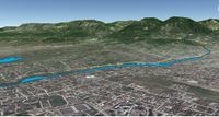
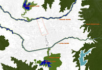
Tirana‟s contact with water is concretized in two lakes (one in north and the other in south) and two rivers (Tirana River and Lana River) that run parallel to each other, between the two lakes. The actual condition of the Tirana River waterfront is weak and the regeneration of it is an important issue for the development of the city.
Its north-south axis, which eventually corresponds to the main boulevard of the city, serves as a connector between the lakes and the rivers. Existing general land use of the area under study and identification of the water surfaces of Tirana city. (Source: GrimShaw analysis and Dar analysis for Tirana Masterplan 2012) “Tirana in the XVI century was defined by a building mosque, a hammam and a bakery,” (Aliaj, Myftiu & Lulo, 2003). So, water was not the most important factor in the foundation of the city, but it was one of the natural resources affecting the growth of its early settlements and melding its future. In the actual situation, there do exist a close relationship between the water and the city. Like other natural elements (Dajti Mountain, hills, agriculture etc.) water influences the urban development and the stratum of the urban fabric.
The urbanization process happens on both sides of the Lana and Tirana River, around lakes. Tirana‟s green regions are strengthened by the topography besieging the urban superficies, the streets, the habitation areas etc. The source of Tirana River is in the mountains to the east. It flows to west through the northern area of the city. In the mountains, it flows through the protected area of Dajti Mountain, providing an ecological corridor, through which wildlife can extend and survive. Its estuary is 30-40 km to the north-west at Rodon Bay, on the Adriatic coast. The topography of Tirana from east to west is nearly 1% slope. The existing natural movement results fast during periods of rainfall, which combined with coarse sand and cobbles by the mountains located close, becomes a destructive force.
After the centralized society dropped to the market
economy in the ‟90s, Tirana, as many other postsocialist
cities of Europe, experienced an extensive
growth by the congestion of the new population that
settled in the periphery of it, which was not well
incorporated into the urban life of the city.
This decentralized action induced spontaneous
settlement by the citizens, with their own resources,
the same as it did in different places of the world,
including Bogota, Bombay, Caracas etc., which
suffer from a high percentage of informality. In
Tirana, the social and spatial pattern viewpoint of
the phenomena is little investigated.
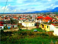
The informal settlements (Kamza, Bathore and Paskuqan, the three major informal housing settlements around Tirana, with over 90% of the dwellings constructed illegally), grew mainly in the early 2000, in suspicious and poor conditions. This gave birth to an “informal city”, which was not acknowledged by the authorities, a self-made structure by rural immigrants which saw Tirana as a better opportunity for their familiar and future life. This city grew without planning control, creating a spatial and cultural disconnection with the existing urban situation. The consolidation of the “selfadding- process” raises the problems of social injury which needs to be resolved. The sustainable development of these areas, the integration and consolidation need a better understanding of these problems, to go to the final solutions. “The segregation involves spatial separation of population groups and spatial separation reduces interaction among groups over space” (Newby, 1982).
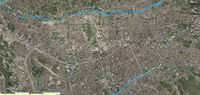
The existing condition of the Tirana river waterfront One of these informal areas is that of the North Tirana (Tirana River area near Paskuqan). The current ecological situation of the urban Tirana River demonstrates waterways and aquifers, poor waste management, contaminated land, deforestation and sporadic urbanization. Ecologically it is poor. As the European and world's experience shows, many of the nowadays healthy river waterfronts, were polluted in the past, so the chances for reversing the natural state are high. “The peculiarity of Tirana stands in the fact that post-socialist socio-spatial transformations are better defined by Balkanization (implying individuality and hostility) rather than segregation (which implies clustering)” (Nase, Ocakçi. 2010). The public space is missing, as it is made property of the individuals which are settled in the area, property of each one alone, not along with the others. These individuals are interested in what evolves inside the fence of their houses and feel like lose character outside these borders. This kind of mentality makes citizens of this area distinguish by a special lifestyle, but not necessarily by good life quality. The rejection of sharing space with others leads to lack of social life, parks, recreational areas etc.. Currently, users of the Paskuqan Park (what is left from the public space) are relatively passive. Furthermore, squares and roads do not seem to provoke social cohesion, because of their structure, their main function of mobility and accessibility between different parts, their narrow or missing sidewalks, the unsafety they offer etc. The area speaks of a bad management of wastes and potentials (resources) too. For example; the natural lake of Paskuqan or the river of Tirana suffers from waste and lack of maintenance, although they have the opportunity to be a clear and real public space. Primary activities are missing, so the functions that take place are residential and rarely commercial
- Illustrations: maps; sketches; short descriptive analyses
- Illustrations
-
 Biogeograpy of the site
 -
 Stellite Map
 -
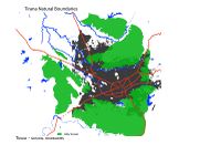 Tirana's Natural Boundaries
 -
 Paskuqani lake aerial
 -
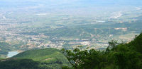
 Study case area
 -
 Main river and lakes of the city
 -
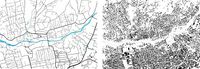 Street snd urban sprawl patterns
 -
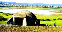
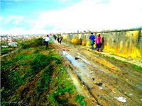
 Informal dwellings on the riverside
 -
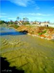
 Paskuqani's lake north Tiana
 -
 Paskuqani's lake surroundings
 -
 River of Tirana, bridge view 2
 -
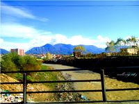 River of Tirana, central bridge view 3
 -
 Strom-water inefficence
 -
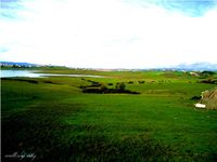
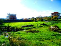 Not functional grasslands near the river


Analytical drawings
- Analytical Drawings
-
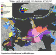 Tirana landuse and informal settlements
 -
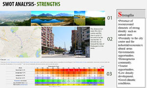 SWOT analysis Strengths
 -
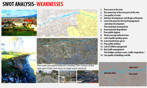 SWOT weaknesses
 -
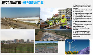 SWOT opportunities
 -
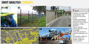 SWOT threats
 -
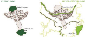 Potential parks of Tirana


Potential for multifunctionality
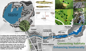
Connectivity benefits:
- 1. Connection of people with the river /pedestrian paths
- 2. Connetion of the two sides of the rivers
- 3. With the future boulevard extension the north part of Tirana will become even more close to the centre and will connect it with the north park of
- 4. Good possibility for developing alternative transport system like tram and bicycle.
Social benefits:
- 1. Multi-functional public facilites
- 2. Improved air quality and life quality
- 3. Increased recreational spaces
- 4. Public education
- 5. Community cohesion
Environmental benefits:
- 1. Increased biodiversity
- 2. Habitat improvement
- 3. Green technologies in the water management
Economic benefits:
- 1. Increased property value
- 2. More job opportunities in planning and executing the project
- 3. Reduced grey infrastructure cost ( almost 50 %)
- 4. Solar energy development because of sunny weather
- 5. Making agriculture fields a means of economic benefit
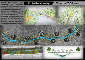
Projective drawings
- Projective Drawings
-
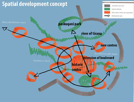 Spatial concept in 10-15 years_Mirsa Gishti
 -
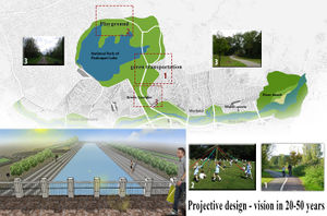
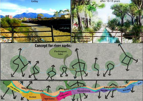 Projective Vision, , Mirsa Gishti
 -
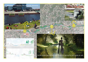 Projective Vision, Paulina Nickl
 -
 Projective Vision, Nataly Montoya
 -
 Projective Vision, Bahman Nahri
 -
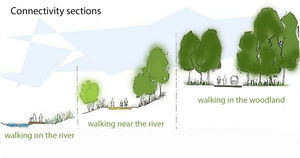 Connectivity sections, Mirsa Gishti


What are the overall objectives of your design? What are the specific objectives for enhancing green infrastrucutre?
The general objectives of our design are:
- 1. Enhance biodiversity
- 2. Improve connectivity
- 3. Create multifunctional green spaces
- 4. Managing stormwater
Specific objectives to enhance green infrastructure:
-To enhance biodiversity we decided to:
- a. Restore the river to its natural condition. Remove beton banks and add riparian vegetations on the river shores.
- b. Connect the existing habitat network and propose new habitats like the wetlandand the creek connecting the wetland and the lake.This will improve living species life conditins and also their mobility through green crridors.
-To Improve connectivity we decided to:
- a. To design new bicycle and pedestrians green paths in order to add more options to public transport system which seems to fail reaaching parks, or nature recreation areas. These paths not only will be functional but will also bring people more near nature, river, lake and woodlands.
- b. Add bicycle routes to existing bus routes and increase bicycle parking points in order to make the switching between different means of transport easier for people.
-To create multifunctional green spaces we decided to:
- a. Use green spaces not only for their aesthetic effect, or improving air quality, but also for cleaning the water, and improving climate changes. (Like the riparian vegetation used near the river and wetland shores.
- b. Create new habitats not only for relaxation but also for enhancing biodiversiity, and creating spaces where children and adults can learn more for the environment.
-To managestormwater through green infratstructure we decided to:
- a. Use permeable pavements in paths, car parkings
- b. Create bioretention cells to the depressed areas of green spaces, helping the drainage of rainfall water.
- c. Design bioswales along the roads green spaces
Design Synthesis
- Design Synthesis Drawings
-
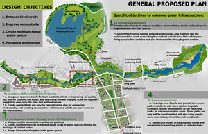 General Proposed Plan_Mirsa Gishti
 -
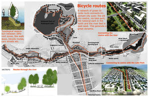 Bicycle paths_Mirsa Gishti
 -
 Biodiersity and habitats connectivity_Mirsa Gishti
 -
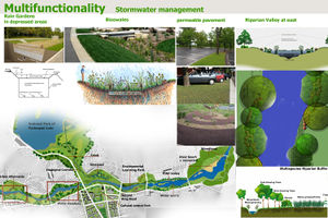 Stormwater management_Mirsa Gishti
 -
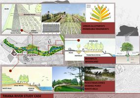 Urban allotments_Nataly Montoya
 -
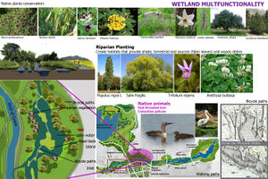 Multifunctionality and Wetland_Mirsa Gishti
 -
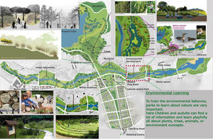 Environmental leraning park _ Paulina Nickl
 -
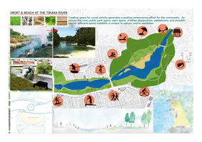 Recreation, Beach and sport_ Paulina Nickl


Summary of the collaborative process
Reflecting our collaborative design process, this points mark clear what it means for us, and how we tried to handle it:
COMMUNICATION: As a team from all over the world, sometimes it was difficult for us to communicate. We managed it via Email and Skype. It was important to talk and not only chat by texting. Special in problem solving situations it was really helpful.
STRUCTURE: To manage the task, we decided to have a leader (Mirsa) who had the commando. We divided the project into different detail topics for each member to work on. So we had the possibility to get for the master plan four intensive worked out themes. Maybe for the next time we could add a more intensive project research, before working on the small topic. But all in all we worked effective and happy with our strategy.
MOTIVATION: The topic was new for three of us, but after talking and reading some research studies about Tirana River or Tirana Master Plan, we got into the project, too. Special because each of us was responsible for one topic, it was a good challenge to get motivated. Also combining the details in one master plan united us as a team.
SHARING: During the working process we get closed and learned about each other. Different levels and working experiences of the members caused an intensive communication how to deal with it. We think for all of us it was a good experience to share how to work, design, think about it in different ways and learn from each other.
References
INTERNET PAGES
- General data of the city
- Extention of Tirana's Boulevard
- Regulatory Plan
- Tirana-GIS database
- Terrain and existing roads map
- Natural boundaries of Tirana
- Aerial view
- Evironmental Policies
- Municipality Project approach-Presentations
- Pollution and waste degradation
- Pollution statistics
- INSTAT,(2009):Albanian Institute Of Statistics, 2009 http://www.instat.gov.al/
- Living species in Tirana lakes and Rivers
- Riparian vegetation in Mediterranean rivers
- Albanian native plants
- [*http://en.wikipedia.org/wiki/List_of_birds_of_Albania/ Albanian native animals]
- http://upload.wikimedia.org/wikipedia/commons/5/54/Populus_nigra-bekes.jpg
- Google Earth Maps
- Existing Conditions [1]
- Existing Conditions [2]
- Existing Conditions [3]
- Existing Conditions [4]
- Existing Conditions [5]
- http://www.epa.gov/oaintrnt/stormwater/best_practices.htm#bioretentioncells
- http://water.epa.gov/infrastructure/greeninfrastructure/index.cfm
![[1]](http://1.bp.blogspot.com/-GMrG8X6-uRg/TZDcB8uDXFI/AAAAAAAABLk/x3pyMRkyN18/s1600/DSC02224.jpg)
![[2]](http://1.bp.blogspot.com/-JXnML0UZ8wQ/TY-SjICM2eI/AAAAAAAABBw/sErrGJYlFqI/s1600/51.jpg)
![[3]](http://3.bp.blogspot.com/-k7cJn09dhFc/TY-S4ONgDbI/AAAAAAAABB4/rbtaILKA9ic/s1600/56.jpg)
![[4]](http://2.bp.blogspot.com/-s5euh64zxUs/TY-fg77dX5I/AAAAAAAABCw/3O6GGbtXEyI/s1600/68.jpg)
![[5]](http://2.bp.blogspot.com/-bIbiV7ISCoU/TY-s2IHEWTI/AAAAAAAABFU/GxYa99tWBjs/s1600/115.jpg)
OTHER
- Aliaj, B., Myftiu, G., Lulo, K. (2003): “Tirana, The Challenge of Urban Development”;Tirana: Cetis
- DAR AL-HANDASAH (shair and partners) (2012): “Tirana delivery report”;to the municipality of Tirana for the master-plan of Tirana
- GRIMSHAW(2012): “Building Tirana's Green Future Competition, Design Report”;to the municipality of Tirana for the master-plan of Tirana
PICTURES AND DETAILS SOURCES
About categories: You can add more categories with this tag: "", add your categories