Group U - Collaborative Climate Adaption Project: Difference between revisions
Jump to navigation
Jump to search
Evelinakny (talk | contribs) |
Evelinakny (talk | contribs) |
||
| Line 45: | Line 45: | ||
*The study area is set in Argentina, in Buenos Aires City (the capital City of the country). This city is the largest city of Argentina, and the second-largest metropolitan area in South America, after São Paulo It is located on the western shore of the estuary of the Río de la Plata, on the southeastern coast of the South American continent. | *The study area is set in Argentina, in Buenos Aires City (the capital City of the country). This city is the largest city of Argentina, and the second-largest metropolitan area in South America, after São Paulo It is located on the western shore of the estuary of the Río de la Plata, on the southeastern coast of the South American continent. | ||
*Around the capital city, grows a conurbation called Greater Buenos Aires, which also includes several Buenos Aires Province districts and constitutes the third-largest conurbation in Latin America, with a population of around thirteen million. | *Around the capital city, grows a conurbation called Greater Buenos Aires, which also includes several Buenos Aires Province districts and constitutes the third-largest conurbation in Latin America, with a population of around thirteen million. | ||
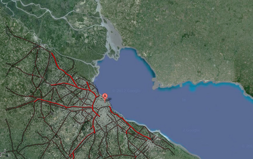
[[File:Transport system.jpg]] | [[File:Transport system.jpg]] | ||
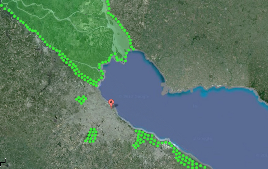
[[File:Green carcass.jpg]] | [[File:Green carcass.jpg]] | ||
Revision as of 00:28, 8 January 2013
| Area | Basin vega stream | |
| Place | Belgrano (CABA -Buenos Aires City) | |
| Country | Argentina | |
| Topic | Climate adaptation plan to the city, dealing with the high level of floods | |
| Author(s) | Evelina Knyzelyte, Teodora Morar, Graciela Spelzini | |
|
| ||
Rationale: Why have you selected this case study area?
- Buenos Aires is a vulnerable area that has developed on the basins of streams that has been piped underground. The city grew without an adequate infrastructure and with climate change,it has serious problems to face strong summer rains.
Authors' perspectives
- From the perspective that gives us our professions, our role is to think and design holistic and interdisciplinary strategies that help facing the challenges posed by climate change.
- Our starting point is the second biggest city of South America, built on flood basins (which pipeline infrastructure is antiquated groundwater). Our proposal elaborates ways of mitigation and adaptation sustainable in time and space.
Landscape and/or urban context
- The study area is set in Argentina, in Buenos Aires City (the capital City of the country). This city is the largest city of Argentina, and the second-largest metropolitan area in South America, after São Paulo It is located on the western shore of the estuary of the Río de la Plata, on the southeastern coast of the South American continent.
- Around the capital city, grows a conurbation called Greater Buenos Aires, which also includes several Buenos Aires Province districts and constitutes the third-largest conurbation in Latin America, with a population of around thirteen million.
Cultural/social/political context
Cultural context:
- Buenos Aires from 1880 to 1930 became a multicultural city, ranked with the major European capitals.
- Sometimes the city is called the ‘Paris of South America’, with the highest concentration of theatres, radio, television and cinema.
- The inhabitants of Buenos Aires tend to consider themselves as different from the people of inland Argentina, more European in character rather than Latin American.
- Since the end of the 19th century, Porteños has come to be the name of the people from Buenos Aires. Porteños are generally extroverted, sophisticated, animated, and on the forefront of the latest trends and fashions, yet their attitudes are tinged with pessimism or fatalism about the direction of their country or the latest economic problems. Some Latin Americans have come to view porteñosas slightly arrogant or snobbish.
- Buenos Aires has a long tradition in visual arts, and it hosts many the most important art galleries. It is also very active in the street art and known for ‚The Night of Museums‘.
- The city sometimes is called ‘the city of books‘, as hundreds of bookstores, public libraries and cultural associations are placed here. Every April in the city, the ‚Buenos Aires International Book Fair‘ is celebrated.
- The city has a world-famous zoo and botanical gardens, a large number of landscaped parks and squares, as well as churches and modern architecture buildings.
Social context:
- Population (in 2010): 2 891 082 people.
- Density: 14,000/km2 (37,000/sq mi), in suburbs – 2,400/km2
- Buenos Aires – is the destination for immigrants from Europe, particularly Italy and Spain.
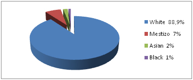
- Racial diversity:
- Mestizos - people of mixed Indian and European ancestry, mainly live in the poorer sections of the city, in the shantytowns, and in the suburbs.
- Belgrano: the 3rd-most populous area in Buenos Aires
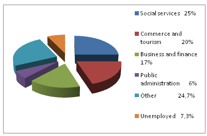
- Employment:
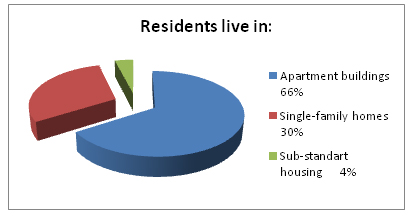
- Accommodation tendencies:
Political context:
- The regional Gross Domestic Product (GDP) of Buenos Aires is US$ 84.7 billion and it comprises about 23% of Argentina’s GDP.
- GDP per capita of 34,200$, when the average of Argentina GDP is about 6.500$.
- Buenos Aires constitutes the 13th largest economy among the world's cities.
- To the west of Buenos Aires is the Pampa Humeda, the most productive agricultural region of Argentina produces wheat, soybeans and corn.
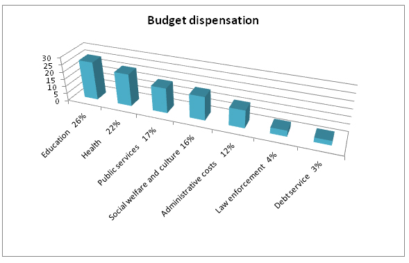
- The city's budget will include US$5.9 billion in revenues and US$6.3 billion in expenditures.
- The city’s budget:
- The Executive is held by the Chief of Government with a Deputy Chief of Government, who presides over the 60-members of Buenos Aires City Legislature.
- By law, the president is responsible for governing the municipality of Buenos Aires, and the National Congress is responsible for legislation pertaining to it.
- The city is divided into administrative units, or communes, each governed by a seven-person citizens’ committee.
Local Climate
Present Climate Conditions:
- Buenos Aires has a humid subtropical climate, with humid summers and mild winters.
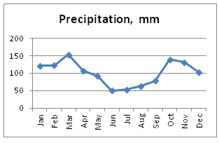
- The city receives 1,242.6 mm of rainfall per year. Rain can be expected at any time of year and hailstorms are not unusual.
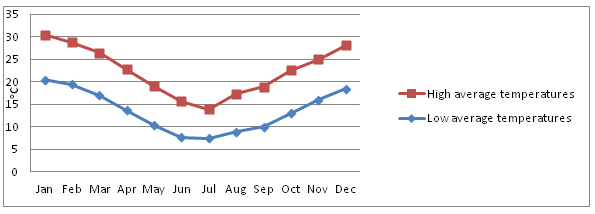
- Annual average temperature - 18 ºC.
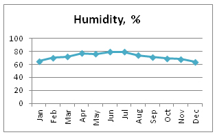
- In the summer, the weather is hot and humid. The peaks of temperature could exceed 35ºC. The warmest month is January, with a daily average of 25.1 °C. Humidity is 64–70%.
- Autumn and spring are rainy seasons with frequent thunderstorms (from March to June and September to December). Humidity averages is higher than 70%, which brings heavy fogs.
- The coldest month is July. The winter average temperature is 11 ºC, it rarely goes below 0ºC. Cold comes from Antarctica, combined with the high wintertime humidity. Winds influence temperature differences from 10 ºC to 20 ºC.
- Two types of regional winds: the ‘Pampero’ and the Southeast. The Southeast mainly occurs in the autumn and spring. It consists of a strong Southeasterly wind, cool and very wet, which lasts for several days and is often accompanied by constant, light rain. It is expected after a sweltering heat in day.
- The continuous wind makes the flood of the Rio de la Plata rise, while it blocks the water coming from the river into the ocean.
- Annual temperatures changes
- Humidity
- Precipitation
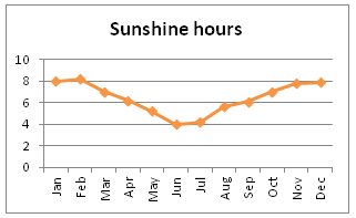
- Sunshine hours
Extreme weather events:
- In 2007 July, Buenos Aires experienced its first major snowfall since 1918 and marked the coldest winter in Argentina in almost thirty years, severe snowfalls and blizzards hit the country.
- In 2010 July, Frigid polar air brought another cold winter with the minimum temperature of -1.5oC. This invasion of cold air covered half of the region with snow, where snow is rare.
- In 2001 August-October Buenos Aires reported almost 250mm of rainfall in October, more than twice the normal amount.
- 2008’s February was the warmest in 50 years. The presence of a dry air mass covering most of central and northern South America inhabited the formation of rain and produced above-normal maximum temperatures.
- Around June 24, in the middle of the winter, the temperatures can reach 24 degrees Celsius. This period is called ‘Veranito de San Juan’.
- ‘Tormenta de Santa Rosa' period on the 30th of August, brings the cycle of rains and thunderstorms that breaks out with the arrival of the spring, at the end of the cold season.
Climate change projections:
- Temperature is intended to increase up to 2.5oC, precipitation 10- 20%
- There has been a general increase in spring and winter temperatures as a result of human influence on climate, making the occurrence of warm seasonal temperatures less frequent.
- In one global-scale study, Argentina was ranked the 5th vulnerable area out of 84 developing countries.
- A sub-national-scale study marked that Buenos Aires could be affected significantly by Sea Level Rise, which will mainly affect areas less than five meters above sea level.
- Climate change will create more flood situations. In 100 years time, the Rio de la Plata is expected to have average water levels that are between 60cm and 1meter higher than today, and stronger winds and storm surges.
- Buenos Aires has also had a significant increase in annual rainfall over recent decades and increasing numbers of intense rainfall events (with over 100mm in 24 hours).
- There is some confidence that there has been a small increase in annual total precipitation between 1960 and 2003 over the central and northern region of the country.
Analysis of vulnerability
- Floods are common occurrences in Buenos Aires. With its close proximity to the Rio de la Plata, it is highly vulnerable area to sea-level rise, storm surges and intense rainfall, because of the inadequacies in provision for storm and surface drainage.
- Most at risk areas are the coastal zone, low-lying lands and areas less than five meters above sea level.
- An ambitious plan to address flooding in Buenos Aires is underway, with support from the World Bank. However, this has not taken into account climate change variables, as it is claims that there is not enough information to allow this.
- One long-term worry is the threat to the Parana Delta, which is an important part of Buenos Aires’s economy and also important as a natural flood-control mechanism, the growth of the delta has slowed, and erosion and floods may destroy it.
- Indicators values for vulnerability components:
- Sea-level rise in a year - 2,1 mm/year
- Storm surge – the rapid rise in the water level surface produced by inshore falling barometric pressure – 4,5m
- Number of cyclones in the last 10 years: 2
- Maximum river discharge in the last 10 years – 80 000 m2/s
- Average foreshore slope – 0,08%
- Soil subsidence – 8 mm/year
- Coastal line along the city – 46 km
- Number of cultural objects in danger when coastal flood occurs – 1300
- Population close to coastal line – 900 000
- Growing coastal population in the last 10 years – 1.2%
- Number of shelters per km2 – 0.7
- Population with any kind of disabilities – 0.36%
- People awareness of floods and preparedness – 5 (from 10 points)
- Recovery time after coastal floods events – 50 days
- Km of drainage – 80 km
- Flood hazard mapping and planning in flood-prone areas – 4.5 (from 10 points)
- Institutional organizations involved in the flood management process – 7
- Uncontrolled planning zone – 0.3%
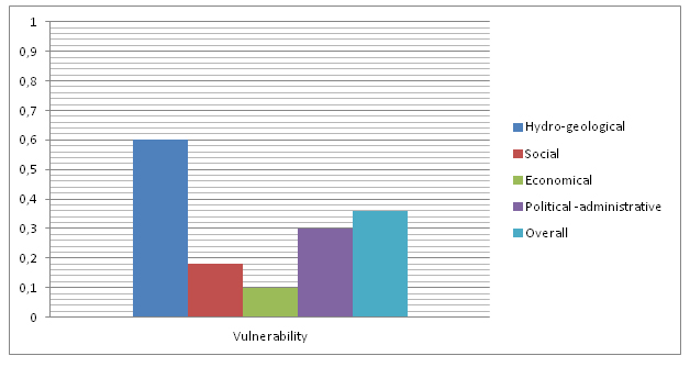
- Overall vulnerability index:
- The graphic describes the vulnerability of different ranges, evaluated by the indexes from 0 to 1.
- Buenos Aires has a very high river discharge value, but very narrow coastline, rare cyclones and very low amount of storm surge. It’s population, cultural heritage, shelters, flood cultural behavior and awareness of floods reflects a relative little value of social vulnerability. Economically, Buenos Aires is not very vulnerable, as the coastal population is slightly growing, recovery time after floods is relative not long, 30 days, and the drainage system is 80 km, insufficient in a case of flood. Political-administrative vulnerability is quite high, as it has the involvement of institutional organizations in the flood management process is very low, just 7, but uncontrolled planning zone indicator is relative small – 0.3%.
- Belgrano map of vulnerability
Proposals for Climate Change Adaption
Proposals:
- Buenos Aires adaptation plan for climate change has to start with environmental education: creating more awareness among citizens, both children and adults. For example we propose panels with information about species, state of the environment etc. in every green area.
- Example of panel with information about species, Jardin du Luxembourg, Paris, 2011
- Source: original
- Example of panel with information about invasive species, Jardin des Plantes, Paris, 2012
- Source: original
- Another important measure for the city to adapt to climate change is to increase the total amount of green spaces per inhabitant, since this can help the city of Buenos Aires to reduce the heat island effect and decrease the impact of floods (EEA report, 2012), while also protecting nature, biodiversity and human health. We propose the implementation of innovative green areas that will increase the total amount of green spaces without depriving people of ground floor, which in this urbanized area are not available for green spaces: Green roofs, Green walls, Brownfields, Grass lined tramways, Permeable pavement, Vegetation corridors.
- Vertical garden in Paris, 2011
- Source: original
- The Belgrano area could become more resilient if several actions for adapting to climate change effects would be implemented. We propose a group of measures to prevent flooding since our study area is still affected by recent heavy floods; therefore we created a system of bridges that will increase mobility during flood periods. Bridges have to be built with sustainable materials. We imagine these bridges as hanging gardens passing through buildings with green roofs. They will increase the resilience to flooding through vegetation while also creating a good aesthetical image and increasing the amount of green spaces in the area. Another measure is to build channels in the street adapted to the increased amount of water during heavy rains, so we propose the rehabilitation of the water drainage system in order to make it more resilient to future changes in the climate. There is another problem in the area that increases the risks of flooding: the “Sudestada” is a wind effect that blows from Rio de la Plata River toward the city, and raises the level of the underground piped streams impeding them from evacuating into the river. To decrease its impact we suggest green walls, strategically implemented in places where the wind affects more, and creating more dense green areas.
- Since there is a lot of water because of the heavy rains we propose rain water storage tanks. The water thus obtained can be used for irrigation and for household consumption. This can assure water in dry periods and can decrease the consumption of drinkable water improperly used for irrigation and some household tasks.
Proposals for Climate Change Mitigation
- We propose a mitigation plan for the city of Buenos Aires, which can begin from the Belgrano area. In order to reduce GHG emissions, we propose reducing emissions from transport, obtaining energy from renewable sources and renovating buildings for efficient energy consumption.
From our research we found out that one of the main sources of GHG emissions is transportation, so we decided to promote a clean transportation program. This plan includes promoting public transportation, bikes, car sharing and walking, therefore reducing the usage of personal car.
- Source: Brochure for “Capital Cultural de Latin America”, in the section Ciudad Verde, under the name Energy Plan for the city
- A rental bike system with pick up points in all the strategic parts of the city and available to everyone should be developed. We propose the building of secure parking spaces for bicycles and bicycle lines that connect the entire city.
- For car sharing, an electrical fleet of cars should be installed in all strategic parts of the city, also near peoples’ homes in order to connect them with their work place.
- For public transportation we propose a fleet of clean buses working on clean energy. We suggest to replace some bus routes with tramways (each tramway could replace 3 buses, found in O’Neill and Rudden, 2012), where it is possible, and we can plant grass to have green ways, thus increasing the amount of green spaces.
- Traffic regulation can help a city become quieter, cleaner and more efficient, as well reduce the impact on inhabitants’ health.
- Road conversion in the city centre is needed to accommodate public transportation with green transport methods in order to exclude individual cars. We suggest high performance public transport links to all areas of the city, thus ensuring mobility and access, whilst reducing the need for individual vehicles.
- Buenos Aires already has a plan to increase efficiency of its energy consumption, mainly for self sustained buildings, which can be found in their brochure for “Capital Cultural de Latin America”, in the section Ciudad Verde, under the name Energy Plan for the city
Your scenario
- How will this area look like in 2060?
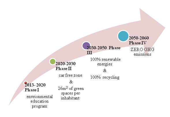
- We propose for the city of Buenos Aires to become a ZERO Green House Gas emission area by 2060. We used the backcasting method, to construct the most suitable scenario for achieving our vision for Buenos Aires 2060. This method is the most appropriate since it entails setting the desired future and going backwards to achieve it step by step, by developing strategies, agendas and pathways that help the city get there. From this standpoint the backcasting method for scenarios is a concept that fits well for sustainability developments (Vergragt and Quist, 2011).
- The backcasting for Buenos Aires helped us establish 4 phases for achieving our goal. We propose that in the first phase (2013-2020) they start with environmental education to prepare the population and to create specialists in the field of sustainable development. In this phase, resilient projects for clean transportation, for increasing the amount of green spaces, for energy efficiency and for recycling should be initiated. In the second phase (2020-2030) the city has to become a car free zone and has to increase its total amount of green spaces from the current value of 1,9m2 per inhabitant to 26m2 per inhabitant. By the end of the third phase (2030-2050) Buenos Aires should use 100% renewable energies and recycle 100% of its waste. For achieving the ZERO Green House Gas emission area, in the last phase (2050-2060) the city needs to control all its sustainable accomplishments and to assure their further development.
What can be generalized from this case study?
- From our research about Buenos Aires, especially Belgrano area we found out that historical development, mainly the inadequate infrastructure is not capable to cope with future challenges in the context of climate change. Therefore we need to make a change in human behaviour regarding climate change. We also need to make a change in our way of thinking about the future, we need sustainable developments in every part of the society.
- Projects for sustainable development for high risk areas generate lots of uncertainties, from the fact that there is little information about the actual state of the environment and the best practices that will help to improve it. People may also be frightened by, and thus not accept, drastic changes. Therefore we need to develop social acceptability programs, beginning with understanding the needs of the population and their current position regarding climate change. We then need to learn how to ease the transition from the present state to a sustainable state without disturbing the population. A key for this can be promoting incentives for citizens and companies to change their way of living and working into a more resilient one. One of the most important aspects for successfully achieving this transition is finance. Governments should work together with other governments and also with private companies to give subsidies for the development of: renewable energies, clean transportation, house rehabilitation and for increasing the amount of green spaces.
- In our proposals concerning poor resilience to climate change of Buenos Aires city and the Belgrano area, we tried to develop a more resistant area for the challenges of the future. Our proposals should be seen as a showcase for other areas in the world facing the same issues due to climate change.
Presentation Slides
- Addnewimagename.jpg
Slide One
- Addnewimagename.jpg
Slide Two
- Addnewimagename.jpg
Slide Three
Image Gallery
- Yourimage.jpg
your image text
- Yourimage.jpg
your image text
- Yourimage.jpg
your image text
- Yourimage.jpg
your image text
- Yourimage.jpg
your image text
- Yourimage.jpg
your image text
- Yourimage.jpg
your image text
- Yourimage.jpg
your image text
References
Please add literature, documentations and weblinks
About categories: You can add more categories with this tag: "", add your categories
