Group V - Collaborative Climate Adaption Project: Difference between revisions
No edit summary |
|||
| Line 14: | Line 14: | ||
| '''Author(s)''' || style="background:Lavender"|''Ana Cecilia Martinez Marletta; Negar Mehryar; Sandra Streipert; Tina Vetter'' | | '''Author(s)''' || style="background:Lavender"|''Ana Cecilia Martinez Marletta; Negar Mehryar; Sandra Streipert; Tina Vetter'' | ||
|- | |- | ||
| colspan="3" align="center" style="background:silver"| [[File: | | colspan="3" align="center" style="background:silver"| [[File:BSC 3058.jpg|270px]] | ||
|- | |- | ||
| ||style="background:Lavender"| | | ||style="background:Lavender"| | ||
Revision as of 16:19, 11 December 2012
| Area | Tehran Province | |
| Place | Tehran | |
| Country | Iran | |
| Topic | please enter the topic here | |
| Author(s) | Ana Cecilia Martinez Marletta; Negar Mehryar; Sandra Streipert; Tina Vetter | |

| ||
|
| ||
Rationale: Why have you selected this case study area?
- Please summarise:- e.g. previous experience, is it your everyday environment?, specific vulnerability, previous research being done etc.
Tehran is the hometown of one of the group members and it is her everyday environment. Tehran is the mega city in the north of Iran and has a good climate which is suffering most from air pollution and crowded population. Other issues that become relevant in this city and regional level are related With The climate as dust storms and floods. Precipitation tend to increase in the wettest areas while in the drier areas decrease. This fact influence the agronomy. Other changes in the weather is snowy winter which starts earlier than expected
Authors' perspectives
- What theoretical or professional perspective do you bring to the case study?
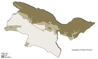
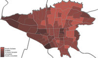
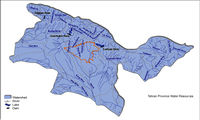
Tehran is situated on a plain at the foot of the Alborz Mountains Presents diversity of climate and terrain. In the relief find a fault beneath the Alborz chain and several smaller faults located in the plains of the south of the city. For this reason the city is exposed to earthquakes. The city does not have major water resources. It is located at an equal distance from two major river basins that collect water coming from the mountains located upstream. Suffers the problems of the big cities of the world: air pollution and hearing, traffic congestion, social class difference. The northern suburbs of the city, located in height on the slopes of Alborz, are the suburbs of the population of the upper middle class of the capital. To the south, toward the desert, are the most popular neighborhoods and industrial. Currently air pollution and rapid population growth are major issue and vulnerability. The environmental capacity for the proper development of quality of life, is insufficient.
Landscape and/or urban context
- Biogeography, land use patterns, cultural features, overall character, history and dynamics
Tehran province is located in the north of the central plateau of Iran. It has common borders from north with Mazandaran, from east with Semnan, from west with Qazvin and from south with Qom. the area of this province is about 18,909 square kilometers and includes Tehran, Damavand, Ray , Shemiranat, Shahriyar, Varamin and Islam Shahr; Savoj Bolaq and Karaj were also 2 parts of this province which has been seperated since 2 years ago and now have become independent provinces. The highest point of the province is Damavand peak, 5,678 m. and the lower parts are the plains of Varamin, 790 m. above sea level. Mountain ranges such as the Alborz in the north; the Savad Kooh and Firooz Kooh are located in the north east; Lavasanat, Qarah Daq, Shemiranat, Hassan Abad and Namak Mountains are in the southern territory; Bibi Shahr Banoo and Alqadr are situated in the south east and the heights of Qasr-e-Firoozeh being located to the east of the province. There are many ancient areas dating back to 6000 years ago have been found in the surrounding regions of Tehran such as Cheshme-Ali, Gheytariyeh, Darrous and Chizer. According to historical documents, until the Moghul Invasion, Tehran was a small village and one of the four parts of Ray. It was selected as the Capital of Iran in 1200 AH. and since then has been the political, cultural, economical part of the country.
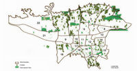
- ratio of green/blue and sealed/built-up areas
- urban green space 79154757 m2
- public parks 17422904 m2
- urban green belt 37000 hectares
- per capita urban green space 6.5 m2
Illustration:
Map; sketches; short descriptive analyses


Cultural/social/political context
- Brief explanation of culture, political economy, legal framework
Illustration: Bullet points, image, background notes
Local Climate
- What are the climatic conditions at present? Have there been extreme weather events in the near past?
- Which changes are expected? Is there any evidence?
Illustration: Table or time line
Analysis of vulnerability
- If you consider these potential changes - which aspects/functions of your case study would be affected?
Illustration: Map/diagram/sketches/photos/background notes
Proposals for Climate Change Adaption
- How could your case study area become more resilient to climate change?
- Which measures would need to be taken to adapt to the new situation?
- How could you assure sustainability of these measures?
- Please describe 2-3 measures
Proposals for Climate Change Mitigation
- Which measures would need to be taken to reduce greenhouse gas emissions and other drivers of climate change within your case study area?
- How could you assure sustainability of these measures?
- Please describe 2-3 measures
Your scenario
- How will this area look like in 2060?
- Please forecast one potential future development taking climate change into account
Illustration: Map/diagram/sketches photos and background notes
What can be generalized from this case study?
- Are there any important theoretical insights?
- Which research questions does it generate?
- Short statement plus background notes
Image Gallery
- Yourimage.jpg
your image text
- Yourimage.jpg
your image text
- Yourimage.jpg
your image text
- Yourimage.jpg
your image text
- Yourimage.jpg
your image text
- Yourimage.jpg
your image text
- Yourimage.jpg
your image text
- Yourimage.jpg
your image text
References
Please add literature, documentations and weblinks
www.atlas.tehran.ir; www.tebyan.net; www.ictcsociety.org
About categories: You can add more categories with this tag: "", add your categories