Addiriyah: Difference between revisions
No edit summary |
No edit summary |
||
| Line 46: | Line 46: | ||
Image:Almreehplan1.jpg|your image text | Image:Almreehplan1.jpg|your image text | ||
Image:Almreeh plan 3.jpg|your image text | Image:Almreeh plan 3.jpg|your image text | ||
Image: | Image:Almreeh plan 7.jpg|your image text | ||
Image:yourimagename.jpg|your image text | Image:yourimagename.jpg|your image text | ||
Image:Almreeh plan 2.jpg|your image text | Image:Almreeh plan 2.jpg|your image text | ||
Revision as of 16:16, 15 November 2011
---> back to overview of Case Study List
Addiriyah Traditional Residential Area, Mraiy'h, Riyadh, Kingdom Of Saudi Arabia
| Name | Addiriyah Traditional residential area | |
| Location | Mraiy'h, Riyadh | |
| Country | Kingdom Of Saudi Arabia | |
| Authors | Dammam 1st group | |
| Editor | Yousef AlBuhairi | |

| ||
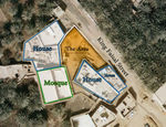
| <googlemap version="0.9" lat="24.734800" lon="46.578100" type="satellite" zoom="19" width="300" height="250">
</googlemap> | ||
Short Introduction to the Area of Study
The important of this area that it was the starting of Saudi Arabia and AD DIRIYAH was the old capital, so this area can be explained as a traditional historical area, also a proud for each Saudi citizen. We choose this area because it can be more active, so people who live there can enjoy this area in different times of the day, also stimulation to perform more social activities. we can use the minaret as an element that attract people (adults and kids) to this area. Finally, the government is really planning to develop this area the coming years.
Exercise 1: Sketching the Landscape
Time frame: October 25 - November 15, 2011
Student activities:
- Creation of analytical drawings and sketches
- Presentation of results
Please upload a selection of your drawings/sketches/mental maps and add them to the image gallery
Sketches and Drawings
-
 your image text
 -
 your image text
 -
 your image text
 -
your image text
-
 your image text


Exercise 2: Landscape Layers
Time frame: November 15 - 29, 2011
- Classical analysis: topography, open spaces, built, green, traffic and water structures on different layers. *Definition of zones with coherent character
- Description of this character.
Please publish your findings here
Exercise 3: Behaviour Patterns
Time frame: December 6 - 20, 2011
- How do people behave in this area? How do they use the space? What is important for them?
- Observation of study area, interviews with local people and mapping of use patterns.
- Preparation of short presentation
Please publish your findings here
Exercise 4: Communication Concepts
Time frame: December 19, 2011 - January 17, 2012
- Based on the different landscape assessment approaches students will develop a communication concept for their area of study
- Which measures would be necessary for enhancing the awareness for the area?
- Students are free to choose their method.
Please publish your findings here
Image Gallery
-
 Simple Traditional House.
 -
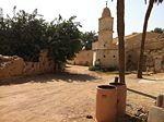
 Part of the area with the mosque in the background.
 -
 Two tall palms in the front of this house.
 -
 View to the mosque corridor and farm.


References
* Please make sure that you give proper references of all external resources used.
* Do not use images of which you do not hold the copyright.
* Please add internet links to other resources if necessary.
About categories: You can add more categories with this tag: "", add your categories