Case Study Clemson 1: Difference between revisions
| Line 52: | Line 52: | ||
=== Analysis of program/function === | === Analysis of program/function === | ||
* What are the main functional characteristics? | * What are the main functional characteristics? | ||
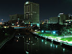
Bike paths, canoe trips and lighting are key elements of the design. Particularly the lighting of the highway overpasses is a unique part of the park, providing an expansion of the program into the night. | |||
* How have they been expressed or incorporated? | * How have they been expressed or incorporated? | ||
Illustration: Map/diagram/sketches photos and background notes | Illustration: Map/diagram/sketches photos and background notes | ||
Revision as of 00:51, 23 November 2010
---> back to overview of Future Landscapes Group 1
Buffalo Bayou by Hanna, Kosnitchzki, McLaughlin, Ogletree, Yonce
| Name | Buffalo Bayout | |
| Location | Houston, Texas | |
| Country | USA | |
| Office | office or planner/designer | |
| Client | Buffalo Bayou Partnership | |
| Completion | in process | |

| ||
| <googlemap version="0.9" lat="29.765718" lon="-95.363903" type="satellite" zoom="15" width="300" height="250">
</googlemap> | ||
Core Question 1: In how far does this project reveal your concept of future landscapes?
Landscape and/or urban context
- Buffalo Bayou is located in Houston, Texas
- It is a major part of the city’s natural landscape that has played an important role in shipping and commerce.
- The Bayou has been transformed from a resource for business to public amenity.
- Buffalo Bayou was restored as public park.
http://upload.wikimedia.org/wikipedia/commons/1/1a/Buffalo_Bayou_map_1869.jpg
Cultural/social/political context
- The project was initiated by the mayor of Houston but then a non-profit organization was formed to manage planning and implementation.
- The non-profit is made up of civic, environmental, governmental and business groups and has a director appointed by the mayor.
Spatial analysis of area/project/plan
- What are the main structural features?
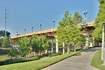
Park is made up of bike/pedestrian paths and boating trails. Many park units make up the green space.
- How has it been shaped? Were there any critical decisions?
Buffalo Bayou has been the source of commerce for Houston. It has been shaped by shipping in the form of dredging. Also it has been managed for flood and insect control.
Illustration: Map/diagram/sketches photos and background notes
Analysis of program/function
- What are the main functional characteristics?
Bike paths, canoe trips and lighting are key elements of the design. Particularly the lighting of the highway overpasses is a unique part of the park, providing an expansion of the program into the night.
- How have they been expressed or incorporated?
Illustration: Map/diagram/sketches photos and background notes
Analysis of design/planning process
- How was the area/project/plan formulated and implemented?
- Were there any important consultations/collaborations?
Illustration: Map/diagram/sketches photos and background notes
Analysis of use/users
- How is the area/project/plan used and by whom?
- Is the use changing? Are there any issues?
Illustration: Map/diagram/sketches photos and background notes
Core Question 2: What is the role of landscape architecture in this project?
You may add 1-2 more core questions as discussed in your group
Image Gallery
-
 your image text
 -
 your image text
 -
your image text
-
your image text
-
your image text


References
- http://openarchitecturenetwork.org/projects/dlygad2_nominee-underspaces1-houston?ob_fs=1
- http://www.buffalobayou.org/guidetobb.html
Image - http://www.flickr.com/photos/jfre81/5130755307/ Image - http://www.flickr.com/photos/euthman/4938197309/ Image - http://www.flickr.com/photos/hellamike81/4550117126/
About categories: You can add more categories with this tag: "", add your categories