Case Study Clemson 3: Difference between revisions
| Line 78: | Line 78: | ||
=== Analysis of design/planning process === | === Analysis of design/planning process === | ||
* How was the area/project/plan formulated and implemented? | * How was the area/project/plan formulated and implemented? | ||
*Were there any important consultations/collaborations? | |||
The | The High Line was originally constructed in the 1930s, to lift dangerous freight trains off Manhattan's streets and has since been converted to be a mile-and-a-half-long elevated park, running through the West Side neighborhoods of the Meatpacking District, West Chelsea and Clinton/Hell's Kitchen. It features an integrated landscape, designed by landscape, combining meandering concrete pathways with naturalistic plantings. Fixed and movable seating, lighting, and special features are also included in the park. Access points from street level will be located every two to three blocks. Many of these access points will include elevators, and all will include stairs. | ||
of | |||
The construction process of the highline was broken into 3 phases. The first phase is to remove all existing surface material on the structure, including gravel ballast, soil, debris and a layer of concrete, down to the steel and concrete structure. After removals, repairs to the steel and concrete are made, new drainage and waterproofing installed, and all steel surfaces of the High Line structure are sandblasted to remove the original lead paint. The final phase in the High Line's transition to a public park was the construction of the park landscape. | |||
Illustration: Map/diagram/sketches photos and background notes | Illustration: Map/diagram/sketches photos and background notes | ||
=== Analysis of use/users === | === Analysis of use/users === | ||
Revision as of 18:53, 22 November 2010
---> back to overview of Future Landscapes Group 3
add your case study title by add authors
Core Question 1: In how far does this project reveal your concept of future landscapes?
This project reveals the future of urban landscapes. The mixture of adaptive reuse of and urban jungle of concrete and highways.
This project combines both function and the over use of highways and concrete and creates a harmonious environment that would normally be chaotic.
Landscape and/or urban context
- Biogeography, cultural features, overall character, history and dynamics
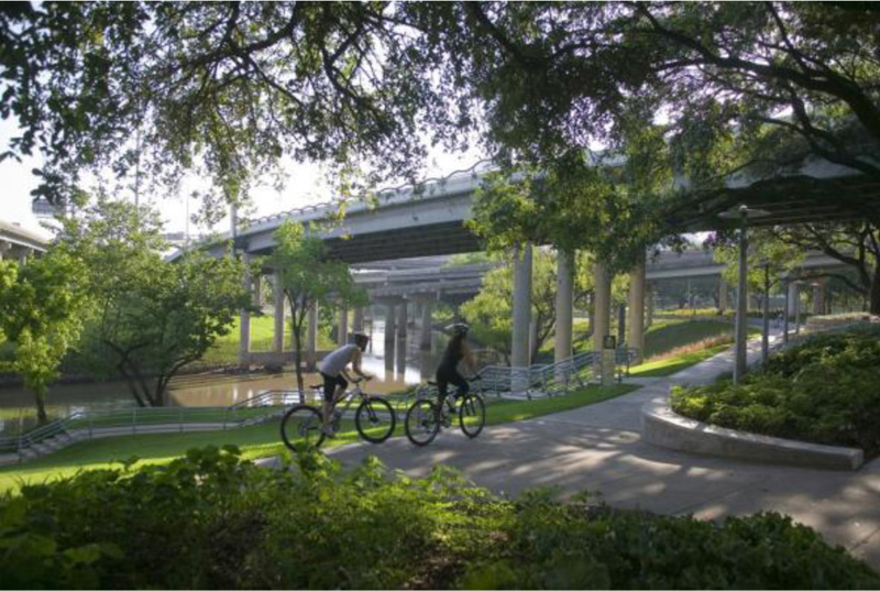
This projects culture is found within the urban chaos of traveling along highways and the dense population of Houston. The design aims to create a park that provides biking and paths but in a more aesthetically appealing way combining park functions with the urban structure of concrete and roads. Creating something that was unusable into a treasure part of Houston. The project plays with connections and linking people.
Illustration: Map; sketches; short descriptive analyses
Cultural/social/political context
- Brief explanation of culture, political economy, legal framework
Illustration: Bullet points, image, background notes
Spatial analysis of area/project/plan
- What are the main structural features?
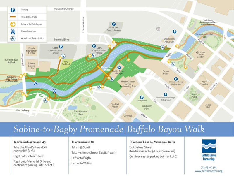
Buffalo Bayou Promenade – highways, stone gabions, Galvanized steel
- How has it been shaped? Were there any critical decisions?
This project has been shaped within the urban fabric of Houston. Using land that was seen as useless is now a thriving park.
The park has been interwoven with other parks nearby among the busy traffic of highways above.
Illustration: Map/diagram/sketches photos and background notes

Analysis of program/function
- What are the main functional characteristics?
Mainly a recreational park this project provides active recreation using bike trails, hiking, playgrounds, boat launch for
canoes, disc golf and a dog park. This project has many other features.
- How have they been expressed or incorporated?
They have been incorporated throughout the rivers edge. Creating an attractive waterfront exercise area while providing
plenty of public parking and entry points from all locations.
Illustration: Map/diagram/sketches photos and background notes
Analysis of design/planning process
- How was the area/project/plan formulated and implemented?
- Were there any important consultations/collaborations?
The High Line was originally constructed in the 1930s, to lift dangerous freight trains off Manhattan's streets and has since been converted to be a mile-and-a-half-long elevated park, running through the West Side neighborhoods of the Meatpacking District, West Chelsea and Clinton/Hell's Kitchen. It features an integrated landscape, designed by landscape, combining meandering concrete pathways with naturalistic plantings. Fixed and movable seating, lighting, and special features are also included in the park. Access points from street level will be located every two to three blocks. Many of these access points will include elevators, and all will include stairs.
The construction process of the highline was broken into 3 phases. The first phase is to remove all existing surface material on the structure, including gravel ballast, soil, debris and a layer of concrete, down to the steel and concrete structure. After removals, repairs to the steel and concrete are made, new drainage and waterproofing installed, and all steel surfaces of the High Line structure are sandblasted to remove the original lead paint. The final phase in the High Line's transition to a public park was the construction of the park landscape.
Illustration: Map/diagram/sketches photos and background notes
Analysis of use/users
- How is the area/project/plan used and by whom?
- Is the use changing? Are there any issues?
The highline has created an alternative space for people to gather and socialize and serve the many functions of a park most importantly as a main transportation transect across the city. This style and approach to restoring and reviving abandoned urban infrastructure allows for a new solution for cities and urban spaces that are declining. It is a new approach for the future of cities and is an example that brings green to cities.
Illustration: Map/diagram/sketches photos and background notes
Core Question 2: What is the role of landscape architecture in this project?
The highline is a really a significant project that represents the landscape urbanism movement done by James Corner that is trying to achieve a mix both architecture and landscape architecture. It is culturally trying to give the people and visitors of New York an attractive, usable and practical green space and environmental project that restores brown field and unused and outdated infrastructure. It is an innovative use of adding green to a city which is an exemplary example of a future landscape because it supports the positive reclaiming of abandoned urban environments and succeeds in promoting a new habitable space that is overwhelmingly needed in many urban areas. The Highline is a new landscape typology, making it not purely architecture and not purely landscape which is critical in allowing for re-engineering of the old use in the urban framework of a city. The site is not only aesthetically powerful but it is ecologically sound, and is preserving the cultural history of the highline of NYC.
You may add 1-2 more core questions as discussed in your group
Image Gallery
- Yourimage.jpg
your image text
- Yourimage.jpg
your image text
- Yourimage.jpg
your image text
- Yourimage.jpg
your image text
- Yourimage.jpg
your image text
References
Please add literature, documentations and weblinks
About categories: You can add more categories with this tag: "", add your categories

