Greenbelt "Fecility": Difference between revisions
| Line 53: | Line 53: | ||
=== Landscape and/or urban context=== | === Landscape and/or urban context=== | ||
*Biogeography, cultural features, overall character, history and dynamics | *Biogeography, cultural features, overall character, history and dynamics | ||
*''Location'' | *''Location and biogeography'' | ||
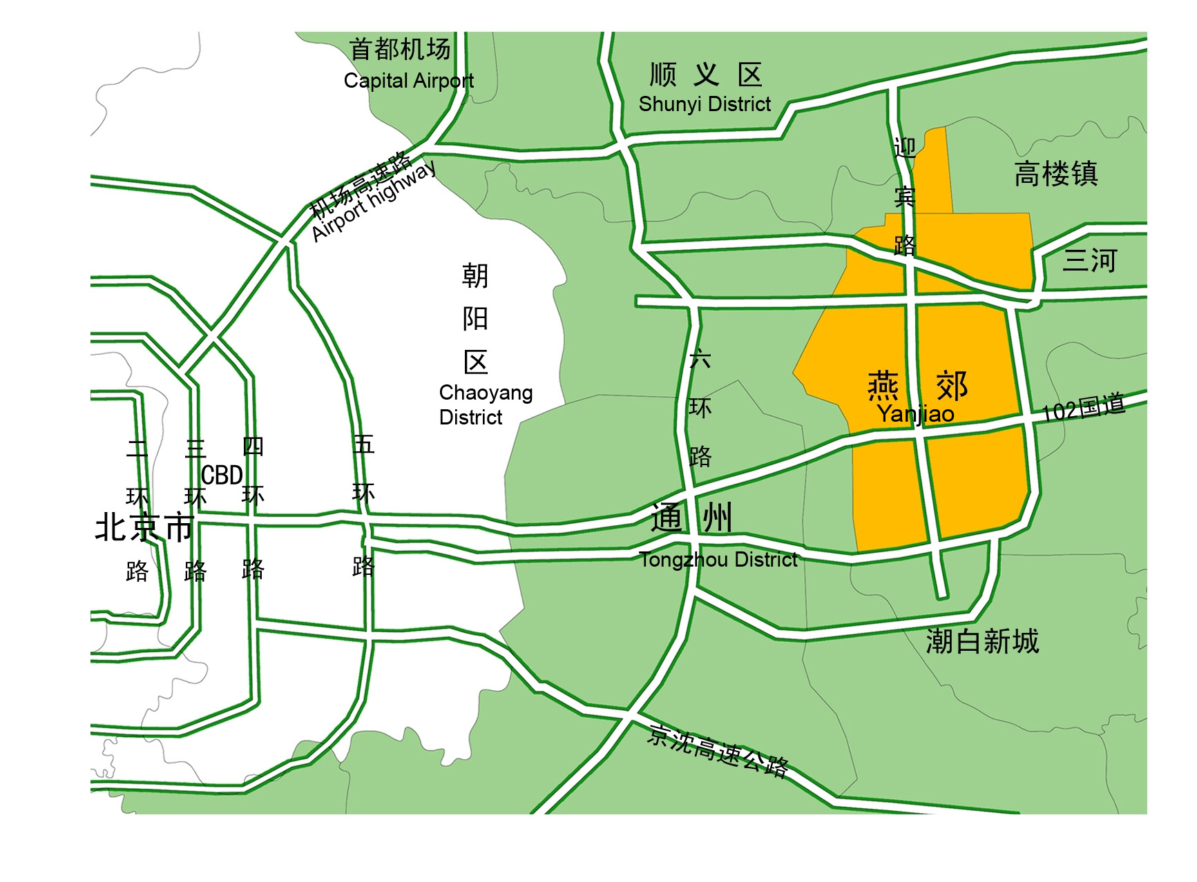
Yanjiao, literally the surburb of the Kingdom Yan(Peking), is 30km away from Tian'anmen Square. | Yanjiao, literally the surburb of the Kingdom Yan(Peking), is 30km away from Tian'anmen Square, 25Km away from Capital airport. | ||
Located in Yanshan Plain, which is originated from the alluvial deposition from ChaoBai river,JiYun river, the average level of Yanjiao is 5.9-31.9 meter above Huanghai. | |||
[[Image:Location Yanjiao.jpg|380px x 320px|left]] | |||
Illustration: | Illustration: | ||
Revision as of 18:18, 17 May 2009
Revitalization development of Greenbelt "Fecility" in Yanjiao, China by Chinyi Gu/Ran Tao
--> Back to Rural Landscapes Seminar Case Study List
Rationale: Why is this case study interesting?
The initial question raised naturally is that
- The development of the greenbelt is actually a defence to prevent the city sprawling or
- it would be forged to serve as a green lung for new city center?
On the political aspect, due to the very location of Yanjiao, which belongs to the big Peking economic circle, local government is intended to maximize the scope of the whole town. The viewpoint of landscape architect is on the contrary.Regarding the severe fragmentation of the landuse in peri-urban area close to Peking, the crucial issue is that if the build up of greenbelt could virtually work as a barrier to isolate the building up of the city from the farming land.
Author's perspective
This case study is firstly applied as the main topic of bachelor thesis by Ran Tao,Beijing Forestry University[1].In the very beginning,the purpose of the project, as the very pioneer work central park in new York city has established, is to spare a recreational area in advance. As a matter of fact,the development of Yanjiao is a mirror reflecting the urbanization of rural area in China. With the re construction of economics, with the redundancy of farming population surging to the city to seek to work chance, the urbanization trends seems to be irreversible.However, how to deal with the change in a sustainable way is the key issue of landscape architecture profession in the next several years. Here we extract this whole story, to formulate two possible consequence of the ending.
Landscape and/or urban context
- Biogeography, cultural features, overall character, history and dynamics
- Location and biogeography
Yanjiao, literally the surburb of the Kingdom Yan(Peking), is 30km away from Tian'anmen Square, 25Km away from Capital airport. Located in Yanshan Plain, which is originated from the alluvial deposition from ChaoBai river,JiYun river, the average level of Yanjiao is 5.9-31.9 meter above Huanghai.
Illustration: Map; sketches; short descriptive analyses
Cultural/social/political context
- Brief explanation of culture, political economy, legal framework
Illustration: Bullet points, image, background notes
History
- How did the area/project/plan at the focus of the case study evolve?
Illustration: Table or time line
Spatial analysis of area/project/plan
- What are the main structural features?
- How has it been shaped? Were there any critical decisions?
Illustration: Map/diagram/sketches photos and background notes
Analysis of program/function
- What are the main functional characteristics?
- How have they been expressed or incorporated?
Illustration: Map/diagram/sketches photos and background notes
Analysis of design/planning process
- How was the area/project/plan formulated and implemented?
- Were there any important consultations/collaborations?
Illustration: Map/diagram/sketches photos and background notes
Analysis of use/users
- How is the area/project/plan used and by whom?
- Is the use changing? Are there any issues?
Illustration: Map/diagram/sketches photos and background notes
Future development directions
- How is the area/project/plan evolving?
- Are there any future goals?
Illustration: Map/diagram/sketches photos and background notes
Peer reviews or critique
- Has the area/ project/plan been reviewed by academic or professional reviewers?
- What were their main evaluations?
Pleas add references, quotes...
Points of success and limitations
- What do you see as the main points of success and limitations of the area/project/plan?
Illustration: Summary table
What can be generalized from this case study?
- Are there any important theoretical insights?
Short statement plus background notes
Which research questions does it generate?
Short statement plus background notes
Image Gallery
- Yourimage.jpg
your image text
- Yourimage.jpg
your image text
- Yourimage.jpg
your image text
- Yourimage.jpg
your image text
- Yourimage.jpg
your image text
- Yourimage.jpg
your image text
- Yourimage.jpg
your image text
- Yourimage.jpg
your image text
- Yourimage.jpg
your image text
- Yourimage.jpg
your image text
References
Please add literature, documentations and weblinks
About categories: You can add more categories with this tag: "", add your categories

