Collaborative Green Infrastructure Design Group E: Difference between revisions
Created page with "---> back to group page working group E '''''Please add the title of your case study here, adjust the map coordinates and repl..." |
|||
| Line 33: | Line 33: | ||
== Landscape and/or urban context of your case == | == Landscape and/or urban context of your case == | ||
*''Biogeography, | |||
* | '''Biography''' | ||
* | ''Khoramshahr is a border and potential city at the border of Iran. A big part of its importance is straightly related to the dozens of oil resources nearby and the other part flashes back to the history when it was a war between Iran and Iraq. This nostalgic city is located adjacent to '''Arvand River''' which defines a part of the border of Iran-Iraq and also provides a livable land for landscape residents. | ||
Unfortunately, at 30 years ago, Khoramshahr was completely destroyed in the war and The city was a ghost town in the 1986 census, but now it is a fairly big city again, as it was before the war. In previous three decades lots of developments has been accomplished but not by a very deep consideration. Arvand River is providing a considerable possibility for having better quality of everything. By good understanding of Green Infrastructure and a wise plan, we can get its benefits to the work and converse the land from mostly gray to green. Along with, re-providing the bed for biodiversity life and also try to make some perfect facilities for public recreation. Although the climate in this landscape is very warm and it would be a big challenge to bring Green Infrastructure theories to the reality, it is worth trying to develop new ideas for environmental and social benefits.'' | |||
'''History''' | |||
In ancient times, the area where the city exists today was under the waters of the Persian Gulf, before becoming a part of the vast marshlands and the tidal flats at the mouth of the Karun River. The small town known as Piyan, and later Bayan appeared in the area no sooner than the late Parthian time in the 1st. Century AD. Whether or not this was located at the where Khoramshahr is today, is highly debatable. | |||
During the Islamic centuries, the Daylamite Buwayhid king, Panah Khusraw Adud ad-Dawlah ordered the digging of a canal to join Karun River (which at the time emptied independently into the Persian Gulf through the Bahmanshir channel, to the Shatt al-Arab (the joint estuary of the Tigris and Euphrates rivers, known in Iran as Arvand Rood). The extra water made the joint estuary more reliably navigable. The channel thus created was known as the Haffar, which exactly described what the channel was. The Haffar soon became the main channel of the Karun, as it is in the present day. Establishment of a port town at the confluence of the Haffar and the Arvand River is natural and may be expected. However, there is absolutely no mention of such a place in the geographical records, while there are an ample mentions of the port of Abadan nearby. | |||
'''Area of interest during the past decade''' | |||
[[File:HistoryLine.jpg|1200px]] | |||
*'''Iran–Iraq War''' | |||
During the Iran–Iraq War it was extensively ravaged by Iraqi forces as a result of Saddam Hussein's scorched earth policy. Prior to the war, Khorramshahr had grown extensively to become Iran's primary non-oil port city, and home to some of the most sprawling neighborhoods in Iran. The population was predominantly wealthy and upper class, and along with Abadan, the prevalent culture was that of modern Iranian cosmopolitanism. | |||
By the end of the war, Khorramshahr had been completely devastated by Saddam Hussein's forces, with very few buildings left intact. Other major urban centres such as Abadan and Ahvaz were also left in ruins, though nowhere nearly as bad as Khorramshahr. The city of Khorramshahr was one of the primary and most important frontlines of the war and has thus achieved mythic status amongst the Iranian population. Because of the war, the population of Khorramshahr dropped from 146,706 in the 1976 census to 0 in the 1986 census. The population reached 34,750 in the 1991 census and by the 2006 census it reached 123,866, and according to World Gazetteer its population as of 2012 is 138,398, making the population close to what it was before the war. | |||
[[File:History-2.jpg|400px]] | |||
[[File:History-1.JPG|270px]] | |||
'''Economy''' | |||
The economy of Khorramshahr is still largely affected by the destruction and depopulation of the city's residents in the 1980s during the first years of the Iran–Iraq War. The main activities are, however, essentially the same as before the war, petroleum production and exports and imports through the city port, though on a much smaller scale as restoration is not yet totally complete, even though three decades have passed since the end of the war. Residents originally from Khorramshahr have also slowly been returning to the city, rebuilding their houses and businesses. | |||
'''Biogeography''' | |||
*'''Climate''' | |||
Khoramshahr city has located in south-west of Khuzestan province, alongside of Karoon River and has 5 meters height of free seas. Although annual raining rate is very low, this city is one of the most verdant cities in Khuzestan province. In general, hot weather, relatively high moisture, drastic sunlight and dusty winds are important meteorology factors, and palm trees, low lattitude, low height and nearness to river are significant climatic factors. | |||
Khorramshahr has long, hot summers and mild, short winters. The mean temperature in summer is 35 degrees celsius, maximum temperature in summer could soar up to 48 degrees Celsius while in winters the minimum temperature could fall around 1 degrees Celsius. The annual rainfall is about 140 mm. Khorramshahr experiences many sandstorms. | |||
[[File:Climate-Khoramshahr.jpg|1075px]] | |||
According to Olgyay divisions, Khuzestan has been placed on climatic group titled “very hot summer and moist summer and without winter “. By transferring summer and winter circumstances of Khoramshahr city on bioclimatic table, it has been resulted that in 6 months of the year (May to September) final limits of weather thermal circumstances is out of comfort area and has a long distance with upper limit (bright shadow area), and sometimes it could not make cold the weather of city by natural methods in limits of human comfort and we have to use mechanic cryogenic instruments, but in winter situations it may make weather hot by sun thermal energy. | |||
*'''Ecosystem Diversity''' | |||
'''Culture Features''' | |||
*'''Overview''' | |||
*'''Festivals and Events''' | |||
*'''Architecture''' | |||
'''Overall Character''' | |||
*'''Role in Local Area''' | |||
*'''Main Landmarks''' | |||
*'''Districts''' | |||
*'''City Breathing Spaces''' | |||
A breathing space in the context of a city can be described as an undeveloped piece of land which provides a perceptual and psychological distance and space between developed areas, and between city users and residents. In a regional sense, the middle area between Karun River and Bahmanshir Canal provides a major breathing space not far from adjacent urban settlement areas. | |||
Breathing spaces need area and space in order to function: they are not merely edges, but require visual depth and extent. They are visual districts rather than visual edges (Lynch, 1960). | |||
The role of breathing spaces in the city is to diffuse the intensity of urban living and to provide opportunities for relief from noise, urban settlement and other people. Therefor the area of interest between the river and the canal can also respond to need for breathing spaces. | |||
[[File:Breathing Spaces.jpg|580px]] | |||
'''Dynamics''' | |||
*'''Rivers''' (Arvand, Karun and Bahmanshir) | |||
Arvand River is a river in southwest Iran of some 200 km (120 mi) in length, formed by the confluence of the Euphrates and the Tigris in the town of al-Qurnah in the Basra Governorate of southern Iraq. The southern end of the river constitutes the border between Iran and Iraq down to the mouth of the river in Iran as it discharges into the Persian Gulf. It varies in width from about 232 metres (761 ft) to 800 metres (2,600 ft) at its mouth. It is thought that the waterway formed relatively recently in geologic time, with the Tigris and Euphrates originally emptying into the Persian Gulf via a channel further to the west. | |||
The area is judged to hold the largest date palm forest in the world. In the mid-1970s, the region included 17 to 18 million date palms, an estimated one-fifth of the world's 90 million palm trees. But by 2002, war, salt, and pests had wiped out more than 14 million of the palms, including around 5 million in Iran and 9 million in Iraq. Many of the remaining 3 to 4 million trees are in poor condition. | |||
{| border="1" class="wikitable" | |||
|+ Rivers | |||
! Ranking | |||
! Name | |||
! River | |||
! Canal | |||
! Multi Nationality | |||
! Silt Depositing | |||
! Navigability | |||
! Number of Bridges | |||
! Swimming Facilities | |||
! Swimming Potentiality | |||
|- | |||
! 1 | |||
| Arvand||Yes||No||Yes||No||Yes||0||No||No | |||
|- | |||
! 2 | |||
| Karun||Yes||No||No||Yes||Yes||3||No||Yes | |||
|- | |||
! 3 | |||
| Bahmanshir||No||Yes||No||No||No||1||No||Yes | |||
|} | |||
[[File:Rivers.jpg|580px]] | |||
[[File:Areas.jpg|580px]] | |||
* Pollution: | |||
The pollution of Arvand River and along with, Karun River and Bahmanshir River is straightly related to Persian Gulf. The Persian Gulf is a 600 – mile body of water. Persian Gulf is the most strategic waterways in the world due to its importance in the global oil transportation. | |||
Due to the war and high rate of water evaporation, extended drilling and oil extraction, pollution of the water has increased alarmingly. The Persian Gulf is now one of the sensitive marine ecosystems. | |||
The Persian Gulf is the presence of coral colonies and plant species and need clear protection because of its crucial role in the earth’s life supporting phenomena. | |||
The effects of industrial pollution, oil spills on the marine environment is forcing us to focus on the problem and the need for coastal conservation. | |||
{| border="1" class="wikitable" | |||
|+ The Major sources of pollutions in Persian Gulf | |||
! Number | |||
! Source | |||
|- | |||
! 1 | |||
| Pollution from ships | |||
|- | |||
! 2 | |||
| Pollution from Land-based sources | |||
|- | |||
! 3 | |||
| Pollution caused by dumping from ships and aircraft | |||
|- | |||
! 4 | |||
| Pollution resulting from exploration and exploitation of the bed of the territorial sea, the continental shelf and the sub-soil thereof | |||
|- | |||
! 5 | |||
| Pollution from other human activities | |||
|} | |||
Besides, the Karun river, a tributary which joins the waterway, deposits large amounts of silt into the river; this necessitates continuous dredging to keep it navigable. | |||
* Role of the Rivers in People's Lives: | |||
* Periodic Droughts: | |||
Drought is a natural phenomenon that can occur in any region and cause economic, social, and environmental losses. It has greater effects in dry and water-deficient regions and is a global threat, but it has not been studied in detail in many countries. During recent decades, drought has exceeded any other natural disaster in number and frequency. | |||
Drought is the result of an abnormally dry period that lasts long enough to cause an imbalance in hydrologic processes (storage and consumption). Reduced precipitation or increased temperature, either alone or together, can cause drought. | |||
Iran has experienced a severe drought during the last three years (1999-2001), the worst drought period in the last 40 years. On the basis of reports by Iran Meteorological Organization, precipitation during 1999, 2000, and 2001 was 24.2, 40, and 28.5 percent less than normal, respectively. Twenty provinces of the country were faced with the crisis, and 62,500 billion Rials (BR) (U.S. $1 = 8,000 Rials) worth of damage occurred. This damage occurred mainly in the agriculture sector and mainly affected poor people. Drought was more severe in the south, center, southeast, and east which also consists Khuzestan province (Khoramshahr is located in this province). | |||
* Predicted Future: | |||
* View Corridor: | |||
*''Illustrations: maps; sketches; short descriptive analyses'' | |||
<gallery caption= "Illustrations" widths="250px" heights="150px" perrow="3"> | |||
Image:Khoramshar in the Rigion.jpg|Khoramshar in the Rigion | |||
Image:Google Map-Whole Landscape.jpg|Khoramshahr City | |||
Image:Area of Interest.jpg|Area of Interest | |||
</gallery> | |||
== What are the overall objectives of your design? What are the specific objectives for enhancing green infrastrucutre? == | == What are the overall objectives of your design? What are the specific objectives for enhancing green infrastrucutre? == | ||
Revision as of 16:28, 13 January 2015
---> back to group page working group E
Please add the title of your case study here, adjust the map coordinates and replace the moa image with a characteristic image of your site
| Name | add name | |||||||||||
| Location | add location | |||||||||||
| Country | add country | |||||||||||
| Authors | add author | |||||||||||

| ||||||||||||
| {{#widget:GoogleMaps | width=300 | height=200 | lat=71.295556 | lng=-156.766389 | zoom=8 | centermarker=yes | maptypecontrol=yes | overviewmapcontrol=yes | largemapcontrol=yes | scalecontrol=yes
}} | ||
Landscape and/or urban context of your case
Biography
Khoramshahr is a border and potential city at the border of Iran. A big part of its importance is straightly related to the dozens of oil resources nearby and the other part flashes back to the history when it was a war between Iran and Iraq. This nostalgic city is located adjacent to Arvand River which defines a part of the border of Iran-Iraq and also provides a livable land for landscape residents.
Unfortunately, at 30 years ago, Khoramshahr was completely destroyed in the war and The city was a ghost town in the 1986 census, but now it is a fairly big city again, as it was before the war. In previous three decades lots of developments has been accomplished but not by a very deep consideration. Arvand River is providing a considerable possibility for having better quality of everything. By good understanding of Green Infrastructure and a wise plan, we can get its benefits to the work and converse the land from mostly gray to green. Along with, re-providing the bed for biodiversity life and also try to make some perfect facilities for public recreation. Although the climate in this landscape is very warm and it would be a big challenge to bring Green Infrastructure theories to the reality, it is worth trying to develop new ideas for environmental and social benefits.
History
In ancient times, the area where the city exists today was under the waters of the Persian Gulf, before becoming a part of the vast marshlands and the tidal flats at the mouth of the Karun River. The small town known as Piyan, and later Bayan appeared in the area no sooner than the late Parthian time in the 1st. Century AD. Whether or not this was located at the where Khoramshahr is today, is highly debatable.
During the Islamic centuries, the Daylamite Buwayhid king, Panah Khusraw Adud ad-Dawlah ordered the digging of a canal to join Karun River (which at the time emptied independently into the Persian Gulf through the Bahmanshir channel, to the Shatt al-Arab (the joint estuary of the Tigris and Euphrates rivers, known in Iran as Arvand Rood). The extra water made the joint estuary more reliably navigable. The channel thus created was known as the Haffar, which exactly described what the channel was. The Haffar soon became the main channel of the Karun, as it is in the present day. Establishment of a port town at the confluence of the Haffar and the Arvand River is natural and may be expected. However, there is absolutely no mention of such a place in the geographical records, while there are an ample mentions of the port of Abadan nearby.
Area of interest during the past decade

- Iran–Iraq War
During the Iran–Iraq War it was extensively ravaged by Iraqi forces as a result of Saddam Hussein's scorched earth policy. Prior to the war, Khorramshahr had grown extensively to become Iran's primary non-oil port city, and home to some of the most sprawling neighborhoods in Iran. The population was predominantly wealthy and upper class, and along with Abadan, the prevalent culture was that of modern Iranian cosmopolitanism.
By the end of the war, Khorramshahr had been completely devastated by Saddam Hussein's forces, with very few buildings left intact. Other major urban centres such as Abadan and Ahvaz were also left in ruins, though nowhere nearly as bad as Khorramshahr. The city of Khorramshahr was one of the primary and most important frontlines of the war and has thus achieved mythic status amongst the Iranian population. Because of the war, the population of Khorramshahr dropped from 146,706 in the 1976 census to 0 in the 1986 census. The population reached 34,750 in the 1991 census and by the 2006 census it reached 123,866, and according to World Gazetteer its population as of 2012 is 138,398, making the population close to what it was before the war.


Economy
The economy of Khorramshahr is still largely affected by the destruction and depopulation of the city's residents in the 1980s during the first years of the Iran–Iraq War. The main activities are, however, essentially the same as before the war, petroleum production and exports and imports through the city port, though on a much smaller scale as restoration is not yet totally complete, even though three decades have passed since the end of the war. Residents originally from Khorramshahr have also slowly been returning to the city, rebuilding their houses and businesses.
Biogeography
- Climate
Khoramshahr city has located in south-west of Khuzestan province, alongside of Karoon River and has 5 meters height of free seas. Although annual raining rate is very low, this city is one of the most verdant cities in Khuzestan province. In general, hot weather, relatively high moisture, drastic sunlight and dusty winds are important meteorology factors, and palm trees, low lattitude, low height and nearness to river are significant climatic factors.
Khorramshahr has long, hot summers and mild, short winters. The mean temperature in summer is 35 degrees celsius, maximum temperature in summer could soar up to 48 degrees Celsius while in winters the minimum temperature could fall around 1 degrees Celsius. The annual rainfall is about 140 mm. Khorramshahr experiences many sandstorms.

According to Olgyay divisions, Khuzestan has been placed on climatic group titled “very hot summer and moist summer and without winter “. By transferring summer and winter circumstances of Khoramshahr city on bioclimatic table, it has been resulted that in 6 months of the year (May to September) final limits of weather thermal circumstances is out of comfort area and has a long distance with upper limit (bright shadow area), and sometimes it could not make cold the weather of city by natural methods in limits of human comfort and we have to use mechanic cryogenic instruments, but in winter situations it may make weather hot by sun thermal energy.
- Ecosystem Diversity
Culture Features
- Overview
- Festivals and Events
- Architecture
Overall Character
- Role in Local Area
- Main Landmarks
- Districts
- City Breathing Spaces
A breathing space in the context of a city can be described as an undeveloped piece of land which provides a perceptual and psychological distance and space between developed areas, and between city users and residents. In a regional sense, the middle area between Karun River and Bahmanshir Canal provides a major breathing space not far from adjacent urban settlement areas.
Breathing spaces need area and space in order to function: they are not merely edges, but require visual depth and extent. They are visual districts rather than visual edges (Lynch, 1960).
The role of breathing spaces in the city is to diffuse the intensity of urban living and to provide opportunities for relief from noise, urban settlement and other people. Therefor the area of interest between the river and the canal can also respond to need for breathing spaces.

Dynamics
- Rivers (Arvand, Karun and Bahmanshir)
Arvand River is a river in southwest Iran of some 200 km (120 mi) in length, formed by the confluence of the Euphrates and the Tigris in the town of al-Qurnah in the Basra Governorate of southern Iraq. The southern end of the river constitutes the border between Iran and Iraq down to the mouth of the river in Iran as it discharges into the Persian Gulf. It varies in width from about 232 metres (761 ft) to 800 metres (2,600 ft) at its mouth. It is thought that the waterway formed relatively recently in geologic time, with the Tigris and Euphrates originally emptying into the Persian Gulf via a channel further to the west.
The area is judged to hold the largest date palm forest in the world. In the mid-1970s, the region included 17 to 18 million date palms, an estimated one-fifth of the world's 90 million palm trees. But by 2002, war, salt, and pests had wiped out more than 14 million of the palms, including around 5 million in Iran and 9 million in Iraq. Many of the remaining 3 to 4 million trees are in poor condition.
| Ranking | Name | River | Canal | Multi Nationality | Silt Depositing | Navigability | Number of Bridges | Swimming Facilities | Swimming Potentiality |
|---|---|---|---|---|---|---|---|---|---|
| 1 | Arvand | Yes | No | Yes | No | Yes | 0 | No | No |
| 2 | Karun | Yes | No | No | Yes | Yes | 3 | No | Yes |
| 3 | Bahmanshir | No | Yes | No | No | No | 1 | No | Yes |


- Pollution:
The pollution of Arvand River and along with, Karun River and Bahmanshir River is straightly related to Persian Gulf. The Persian Gulf is a 600 – mile body of water. Persian Gulf is the most strategic waterways in the world due to its importance in the global oil transportation. Due to the war and high rate of water evaporation, extended drilling and oil extraction, pollution of the water has increased alarmingly. The Persian Gulf is now one of the sensitive marine ecosystems.
The Persian Gulf is the presence of coral colonies and plant species and need clear protection because of its crucial role in the earth’s life supporting phenomena. The effects of industrial pollution, oil spills on the marine environment is forcing us to focus on the problem and the need for coastal conservation.
| Number | Source |
|---|---|
| 1 | Pollution from ships |
| 2 | Pollution from Land-based sources |
| 3 | Pollution caused by dumping from ships and aircraft |
| 4 | Pollution resulting from exploration and exploitation of the bed of the territorial sea, the continental shelf and the sub-soil thereof |
| 5 | Pollution from other human activities |
Besides, the Karun river, a tributary which joins the waterway, deposits large amounts of silt into the river; this necessitates continuous dredging to keep it navigable.
- Role of the Rivers in People's Lives:
- Periodic Droughts:
Drought is a natural phenomenon that can occur in any region and cause economic, social, and environmental losses. It has greater effects in dry and water-deficient regions and is a global threat, but it has not been studied in detail in many countries. During recent decades, drought has exceeded any other natural disaster in number and frequency.
Drought is the result of an abnormally dry period that lasts long enough to cause an imbalance in hydrologic processes (storage and consumption). Reduced precipitation or increased temperature, either alone or together, can cause drought. Iran has experienced a severe drought during the last three years (1999-2001), the worst drought period in the last 40 years. On the basis of reports by Iran Meteorological Organization, precipitation during 1999, 2000, and 2001 was 24.2, 40, and 28.5 percent less than normal, respectively. Twenty provinces of the country were faced with the crisis, and 62,500 billion Rials (BR) (U.S. $1 = 8,000 Rials) worth of damage occurred. This damage occurred mainly in the agriculture sector and mainly affected poor people. Drought was more severe in the south, center, southeast, and east which also consists Khuzestan province (Khoramshahr is located in this province).
- Predicted Future:
- View Corridor:
- Illustrations: maps; sketches; short descriptive analyses
- Illustrations
-
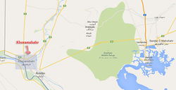 Khoramshar in the Rigion
 -
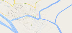 Khoramshahr City
 -
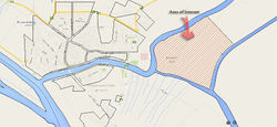 Area of Interest


What are the overall objectives of your design? What are the specific objectives for enhancing green infrastrucutre?
Please give a short written argumentation (not more than 150 words). It is ok if you have different or even contradicting objectives within your group. Just make it explicit at the beginning of your process
Analytical drawings
Please add four analytical sketches/drawings (or montages/schemes) of your case. Every group member needs to contribute at least one drawing.
- Analytical Drawings
-
analytical drawing 1
-
analytical drawing 2
-
analytical drawing 3
-
analytical drawing 4
Projective drawings
Please add four projective sketches/drawings (or montages/schemes), of course with an emphasis on green infrastructure aspects. Every group member needs to contribute at least one drawing representing his/her individual ideas.
- Projective Drawings
-
projective drawing 1
-
projective drawing 2
-
projective drawing 3
-
projective drawing 4
Design Synthesis
Please analyse the individual approaches presented so far and evaluate their strengths and weaknesses (you may use the SWOTanalysis model). Try to create a synthesis and represent it with a plan and some sketches. You can still use drawings/sketches.
- Design Synthesis Drawings
-
synthesis drawing 1
-
synthesis drawing 2
-
synthesis drawing 3
-
synthesis drawing 4
Summary of the collaborative process
Please reflect on your collaborative design process. Which potentials have you encountered? What was most difficult? What does collaborative design mean for you? (approx 150 words).
Image Gallery
You may add a series of images/photos in addition to the sketches/drawings
- Image Gallery
-
image 1
-
image 2
-
image 3
-
image 4
References
* Please make sure that you give proper references of all external resources used.
* Do not use images of which you do not hold the copyright.
* Please add internet links to other resources if necessary.
About categories: You can add more categories with this tag: "", add your categories