Juramento Street: Difference between revisions
| Line 51: | Line 51: | ||
<gallery caption=" " widths="150px" heights="150px" perrow="5"> | <gallery caption=" " widths="150px" heights="150px" perrow="5"> | ||
Image: | Image:Foto_areas_1965.jpg|your image text | ||
Image: | Image:Foto_areas_1965.jpg|Belgrano in 1965 | ||
Image:proceso de urbanizacion buenos aires 1809.jpg|your image text | Image:proceso de urbanizacion buenos aires 1809.jpg|your image text | ||
Image:yourimagename.jpg|your image text | Image:yourimagename.jpg|your image text | ||
Revision as of 03:15, 29 November 2011
---> back to overview of Case Study List
Juramento street and surronding
| Name | Juramento street | |
| Location | Buenos Aires | |
| Country | Argentina | |
| Authors | Ana Martinez Marletta, Malena Giusti, Alexia Anastassiadis | |

| ||
| <googlemap version="0.9" lat="-34.559552" lon="-58.448596" zoom="15" width="300" height="250">
</googlemap> | ||
Short Introduction to the Area of Study
please give a short summary why you have chosen this area, its main features and context (circa 150 words)
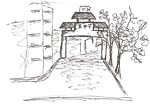
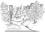
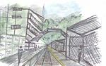
The area we chose to work with, “Juramento Street”, is a great avenue located in the city of Buenos Aires. This street is very popular. There take place different activities at the same time: the street is well known by the facilities that offers for public transport; a train station and an underground station are near this avenue, and many buses travel through it. Near the train station there is a great slope transformed into a park that separates the buildings from the streets and rail ways. Besides, the street crosses the neighborhood of Belgrano, which is very residential, and has a considerable population in the city. The Juramento Street itself and the surrounds are very commercial. It is easy to find any kind of shops, but most of them are clothing and coffee’s stores. Also, very close to Juramento Street is located a Chinese town that attracts the visits of hundreds of people.
Exercise 1: Sketching the Landscape
Time frame: October 25 - November 15, 2011
Student activities:
- Creation of analytical drawings and sketches
- Presentation of results
Please upload a selection of your drawings/sketches/mental maps and add them to the image gallery
-
 your image text
 -
 your image text
 -
your image text
-
 your image text
.jpg)
.jpg)

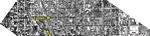
Exercise 2: Landscape Layers
Time frame: November 15 - 29, 2011
- time based changes and 'landscape biography', and/or:
- topography, open spaces, built, green, traffic and water structures on different layers. *Definition of zones with coherent character
- Description of this character.
-
 your image text
 -
Belgrano in 1965
-
your image text
-
your image text
-
your image text
Please publish your findings here
Exercise 3: Behaviour Patterns
Time frame: December 6 - 20, 2011
- How do people behave in this area? How do they use the space? What is important for them?
- Observation of study area, interviews with local people and mapping of use patterns.
- Preparation of short presentation
Please publish your findings here
Exercise 4: Communication Concepts
Time frame: December 19, 2011 - January 17, 2012
- Based on the different landscape assessment approaches students will develop a communication concept for their area of study
- Which measures would be necessary for enhancing the awareness for the area?
- Students are free to choose their method.
Please publish your findings here
Image Gallery
-
your image text
-
your image text
-
your image text
-
your image text
-
your image text
References
* Please make sure that you give proper references of all external resources used.
* Do not use images of which you do not hold the copyright.
* Please add internet links to other resources if necessary.
About categories: You can add more categories with this tag: "", add your categories